Lighthouses of Indonesia: Southern Riau, Sumatra

Indonesia is a huge country of Southeast Asia, stretching along both sides of the Equator for more than 46 degrees of longitude (roughly 5100 km or 3200 miles). It occupies 17,504 islands, by official count, including more than 6000 inhabited islands. It is the world's fourth most populous nation with a population currently estinated at about 280 million. More than half of the population lives on the island of Java. Other major islands include Sumatra in the west, Borneo (shared with Malaysia and Brunei) in the northwest, Sulawesi in the northeast, and the eastern half of New Guinea in the far east. Other well known islands include Bali, Lombok, Sumbawa, Flores, and Timor (shared with independent East Timor) along the south side of the country.

The unification of the country was accomplished over many years of struggle by Dutch colonial authorities. The Dutch East India Company was founded in 1602 to establish and extend Dutch administration, and after the company folded in 1800 the Netherlands established the Dutch East Indies colony and gradually extended its boundaries to include the present territory of Indonesia. During World War II Japan occupied the islands from March 1942 to the end of the war in 1945. The Republic of Indonesia proclaimed its independence immediately after the war ended and following some conflict the Netherlands accepted the country's independence in 1949.

Sumatra (Sumatera in Indonesian) is the world's sixth largest island and the westernmost of the major islands of Indonesia. It is separated from Malaysia to the north by the Malacca Strait, from Kalimantan (Borneo) to the northeast by the broad Karimata Strait, and from Java to the southeast by the Sunda Strait. Its south coast faces the open Indian Ocean.

Indonesia is divided into 38 provinces (provinsi) and the provinces are subdivided into county units called regencies (kabupaten). Sumatra includes eight of the provinces. This page includes lighthouses of the central eastern coast of Sumatra in the southern section of Riau Province, which faces northeast on the Malacca Strait and southeast on the Riau Islands opposite Singapore. This area includes the large Bengkalis Island and the Meranti Islands..

More than 700 languages are spoken in Indonesia. The official national language, Indonesian (Bahasa Indonesia), was standardized from a form of Malay that served as a lingua franca across the archipelago. In Indonesian a lighthouse is a mercusuar or a menara suar. Tanjung is a cape, ujung is a headland or point of land, bukit is a hill, sungai is a river, kuala or muara is an estuary or river mouth, pulau is an island, karang is a reef, batu is a rock, laut is a sea, selat is a strait, teluk is a bay, pelabuhan is a harbor, and labuhan is a port.

Aids to navigation in Indonesia are operated and maintained by the Directorate of Marine Navigation within the Directorate General of Sea Transportation.

ARLHS numbers are from the ARLHS World List of Lights. Admiralty numbers are from volumes F and Q of the Admiralty List of Lights & Fog Signals. (Volume F includes lights north of the Equator and Volume Q includes lights south of the Equator.) U.S. NGA List numbers are from Publication 112.

General Sources
Lighthouses in Indonesia
Photos by various photographers available from Wikimedia; most of the photos are historic.
World of Lighthouses - Indonesia
Photos by various photographers available from Lightphotos.net.
Online List of Lights - Indonesia - Volume F and Volume Q
Photos by various photographers posted by Alexander Trabas. Volume F includes lights north of the Equator, Volume Q lights south of the Equator.
GPSNavigationCharts
Nautical charts for the Malacca Strait area.

Bengkalis Light, Pulau Bengkalis, July 2019
Google Maps street view
Bengkalis Regency: Bengkalis Strait Entrance Lighthouses
Bengkalis Island is a large island, about 100 km (62 mi) long and up to 20 km (13 mi) wide. The Bengkalis Strait separates the west end of the island from the mainland to the southwest and the very narrow Padang Strait separates it from Padang Island to the south. The north and east sides of the island face the open Malacca Strait.

Tanjung Bakau C (Range Rear)
Date unknown. Active; focal plane 29 m (95 ft); white light, 2 s on, 2 s off. 28 m (92 ft) skeletal tower, painted white. No photo available but Google has a satellite view and a distant street view. This is an outbound range for vessels leaving Bengkalis; it shares a front light tower with the Range Rear B light. Located on the south side of the strait leading to Bengkalis. Site status unknown. ARLHS IDO-293; Admiralty F1404.1; NGA 22536.
Tanjung Bakau A (Common Front) (1 and 2)
Date unknown. Active; focal plane 15 m (49 ft); quick-flashing white light. Two towers: approx. 18 m (59 ft) and 15 m (49 ft) square white skeletal towers mounted on platforms supported by piles. The towers are at the right edge of a 2022 photo, a distant view from shore is available, and Google has a satellite view. The light was presumably moved to the taller tower recently. Located just offshore, 1 km (0.6 mi) east of Light C and 760 m (0.5 mi) north of Light B. Accessible only by boat but there is a good view from the nearby Tenggayun Beach. Site open, tower closed. Admiralty F1404; NGA 22528.
Tanjung Bakau B (Range Rear)
Date unknown. Active; focal plane 29 m (95 ft); white light, 2 s on, 2 s off. 28 m (92 ft) skeletal tower, painted white. The lighthouse is near the right edge of Rudi Haryanto's drone view and Google has a satellite view. This is an inbound range for vessels approaching Bengkalis; it shares a front light tower with the Range Rear C light (previous entry). Located on the south side of the strait leading to Bengkalis. Site status unknown. ARLHS IDO-292; Admiralty F1403.9; NGA 22532.

Bengkalis Regency and City: Pulau Bengkalis Lighthouses
The regency capital of Bengkalis is a city of about 85,000 residents on the south side of the island of Bengkalis, just off the mainland of Sumatra.

* Bengkalis
Date unknown. Active; focal plane 32 m (105 ft); white flash every 10 s. 30 m (98 ft) square skeletal tower with gallery. Google has a 2023 street view (the 2019 version is at the top of this page) and an indistinct satellite view. Located two blocks behind the ferry terminal in Bengkalis, south of the intersection of Sudirman and Syahbandar streets. Site status unknown but the tower is easy to see from nearby streets. Admiralty F1407; NGA 22544.
Tanjung Jati (2?)
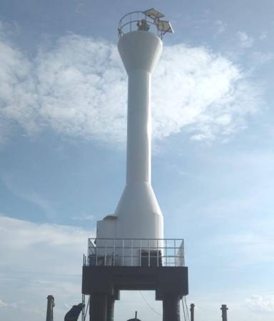
Date unknown. Active; focal plane 16 m (52 ft); white light, 2 s on, 6 s off. Approx. 15 m (49 ft) white barbell-shaped fiberglass tower. A closeup 2022 photo is at right and the light is visible in Google's satellite view of the area. Located at the western tip of Pulau Benkalis and on the north side of the entrance to the Bengkalis Strait. Site status unknown. Admiralty F1406; NGA 22542.
Tanjung Parit (1 and 2)
Date unknown. Active; focal plane 42 m (138 ft); white flash every 5 s. 40 m (131 ft) skeletal tower, painted white. Several coast guard buildings. No photo available but Google has a satellite view of the station. The present lighthouse appears to have replaced a tower about 20 m (66 ft) tall. Located on a swampy cape at the northeastern corner of Bengkalis Island. Site status unknown. ARLHS IDO-320; Admiralty F1413.5; NGA 22580.
Gosong Clark (Clark Bank)
Date unknown. Active; focal plane 14 m (46 ft); white flash every 3 s. 14 m (46 ft) tower painted white. No photo available and the light is not shown in Google's satellite view. Located on a shoal on the south side of the main channel in the Strait of Malacca, about 25 km (15 mi) north of Pulau Bengkalis. Accessible only by boat. Site status unknown. Admiralty F1398; NGA 22578.
Tanjung Sekodi (2)
Around 2010. Active; focal plane 31 m (102 ft); white flash every 7.5 s. Approx. 28 m (92 ft) robust white post with gallery. A 2020 photo and Muhammad Asri's video show the tower and concrete foundation blocks that supported the previous skeletal tower. Google has a distant satellite view. Located on a platform just off a swampy cape at the southeastern corner of Bengkalis Island. Site status unknown. Admiralty F1413.7; NGA 22580.7.

Bengkalis Regency: Mainland Lighthouse
#Sungai Siak Range Rear
Date unknown. Apparently removed; listed with focal plane 14 m (46 ft); white flash every 3 s. Approx. 13 m (43 ft) white skeletal tower. No photo available. Recent images do not show the tower and the light is not seen in Google's satellite view. The Siak River flows into the Bengkalis Strait south of the city. Located on the west bank of the river. Site status unknown. Admiralty F1413.1; NGA 22560.

Tanjung Jati Light, Pulau Bengkalis, September 2022
Google Maps photo by FX Michael

Kepulauan Meranti (Meranti Islands) Regency Lighthouse
The Meranti Islands stretch southeastward from Bengkalis Island (which would be one of them, geographically). The four largest islands are Padang, Rangsang, Merbau, and Tebing Tinggi. The islands are separated from one another and from the mainland by narrow straits. Rangsang Island is outermost, facing the south end of the Malacca Strait.

Bandul
Date unknown. Active; focal plane 12 m (39 ft); red flash every 10 s. 12 m (39 ft) red skeletal tower on a platform supported by piles. No photo available but Google has a satellite view. Located opposite the Tanjung Sekodi Light (see above) on the south side of the entrance to the Padang Strait separating Pulau Padang from Pulau Bengkalis. Accessible only by boat. Site open, tower closed. Admitalty F1413.75.
Tanjung Mayung
Date unknown. Active; focal plane about 12 m (39 ft); white light, pattern unknown. Approx. 12 m (39 ft) white skeletal tower on a platform supported by piles. No photo available but Google has a satellite view. Located just off the southern tip of Pulau Padang. Accessible only by boat. Site open, tower closed. Admitalty F1413.8.
Tanjung Ringgit
Date unknown. Active; focal plane about 12 m (39 ft); red light, pattern unknown. Approx. 12 m (39 ft) red skeletal tower on a platform supported by piles. No photo available but Google has a satellite view. Located just off the southern tip of Pulau Merbau marking the junction of the straits separating Merbau, Padang, and Tebing Tinggi. Accessible only by boat. Site open, tower closed. Admitalty F1414.
Tanjung Bohmat
Date unknown. Active; focal plane 12 m (39 ft); red flash every 10 s. 12 m (39 ft) red skeletal tower on a platform supported by piles. No photo available but Bing has a fuzzy satellite view. Located on the east side of the northern entrance to the Asam Strait separating Pulau Padang from Pulau Merbau. Accessible only by boat. Site open, tower closed. Admitalty F1413.77.
Tanjung Kungkung (2?)
Date unknown. Active; focal plane 14 m (46 ft); one long green flash every 7 s. 14 m (46 ft) green fiberglass tower. No photo available but Google has a fuzzy satellite view. A nearby platform probably held a previous skeletal tower. Located on the west side of the northern entrance to the Kungkung Strait separating Pulau Merbau from Pulau Rangsang. Accessible only by boat. Site open, tower closed. Admitalty F1414.6.
* Selat Panjang
Date unknown. Active; focal plane about 18 m (59 ft); white light, pattern unknown. Approx. 16 m (52 ft) square white skeletal tower. Della Adelia's 2023 photo is at right, Poernawan Zuhri has a 2019 view, Barbermen Budimen has a distant view from the water, and Bing has a satellite view. Selat Panjang, a city of about 80,000 residents on Pulau Tebing Tinggi, is the capital of the Meranti Islands Regency. Located a short distance west of the ferry terminal at Selat Panjang. Site probably open, tower closed. Admiralty F1416.
Tanjung Menggung
Date unknown. Active; focal plane 16 m (52 ft); white flash every 5 s. 16 m (52 ft) square white skeletal tower mounted on a platform supported by piles. No photo available and Google has only a fuzzy satellite view of the area. Located off the southern tip of Pulau Rangsang. Accessible only by boat. Site open, tower closed. Admiralty F1417; NGA 22590.

Selat Panjang Light, Selat Panjang, August 2023
Google Maps photo by Della Adelia

Siak Regency Lighthouse
Siak Regency occupies the mainland of Sumatra facing the Meranti Islands.

Futong
Date unknown. Active; focal plane at least 25 m (82 ft); light characteristics unknown. Square white skeletal tower at least 25 m (82 ft) tall. A portion of Selfi Andriani's photo is at right and Google has a satellite view. Located at Futong, a mainland seaport opposite the west end of Pulau Tebing Tinggi. Site status unknown. Admiralty F1413.94.

Indragiri Hilir (Lower Indragiri) Regency (Northern Berhala Strait) Lighthouses
The Berhala Strait separates the Indragiri Hilir Regency from the southern Riau Islands, southwest of Singapore. The strait is generally 25-40 km (15-25 mi) wide.

Tanjung Ungo
Date unknown. Active; focal plane 12 m (39 ft); white flash every 5 s. 12 m (39 ft) square white skeletal tower on a platform supported by piles. No photo available but Google has a satellite view. Located just off Tanjung Ungo marking the entrance to a strait separating the mainland from Pulau Mendol, the southernmost of the Meranti Islands. Accessible only by boat. Site open, tower closed. Admiralty F1428.4.
Pulau Burung
Date unknown. Active; focal plane 12 m (39 ft); red flash every 5 s. 12 m (39 ft) square red skeletal tower on a platform supported by piles. No photo available and but Bing has a satellite view. Located on a shoal northwest of Pulau Burung and about 25 km (15 mi) southeast of Tanjung Ungo. Accessible only by boat. Site open, tower closed. Admiralty F1428.44.
Tanjung Datuk (Tanjung Dato)
Date unknown. Active; focal plane 25 m (82 ft); white flash every 5 s. 25 m (82 ft) square white skeletal tower on a square platform supported by piles. No photo available but Google has a satellite view. A short distance southwest a monument marks the Equator. Located just off a swampy point on the west side of the Berhala Strait. Accessible only by boat. Site status unknown. ARLHS IDO-300; Admiralty F1429; NGA 22616.

Futong Light, Futong, October 2016
Google Maps photo by Selfi Andriani
Pulau Busang
Date unknown. Active; focal plane 13 m (43 ft); white flash every 3 s. 13 m (43 ft) square white skeletal tower on a platform supported by piles. No photo available but Google has a satellite view. Located off the east end of Pulau Busang marking the entrance to Kualacenaku Bay, the inlet between Tanjung Dato and Tanjung Bakau. Accessible only by boat. Site open, tower closed. Admiralty Q0981.75.
Teluk Kualacenaku
Date unknown. Active; focal plane about 13 m (43 ft); white light, pattern unknown. Approx. 13 m (43 ft) round barbell-shaped white fiberglass tower on a platform supported by piles. No photo available but Bing has a satellite view. Located in Kualacenaku Bay at the entrance to the Batangtuaka River. Accessible only by boat. Site open, tower closed. Admiralty Q0981.73.
Sungai Batangtuaka
Date unknown. Active; focal plane about 13 m (43 ft); green light, pattern unknown. Approx. 13 m (43 ft) round barbell-shaped green fiberglass tower on a platform supported by piles. No photo available but Google has a satellite view. Located off a swampy point on the north side of the Batangtuaka River. Accessible only by boat. Site open, tower closed. Admiralty Q0981.72.
Tanjung Bakau
Date unknown. Active; focal plane 15 m (49 ft); two white flashes every 10 s. 15 m (49 ft) square white skeletal tower on a platform supported by piles. No photo available but Bing has a satellite view. Located off a swampy point about 30 km (19 mi) south of Tanjung Datuk. Accessible only by boat. Site status unknown. Admiralty Q0981; NGA 22720.
Gosong Pentekuk Tembilahan
Date unknown. Active; focal plane about 13 m (43 ft); green light, pattern unknown. Approx. 13 m (43 ft) square skeletal tower on a platform supported by piles. No photo available but Bing has a satellite view. Located on the north side of the Indragiri River about 12 km (7.5 mi) east of Tembilahan. Accessible only by boat. Site open, tower closed. Admiralty Q0981.7.
* Tembilahan (2?)
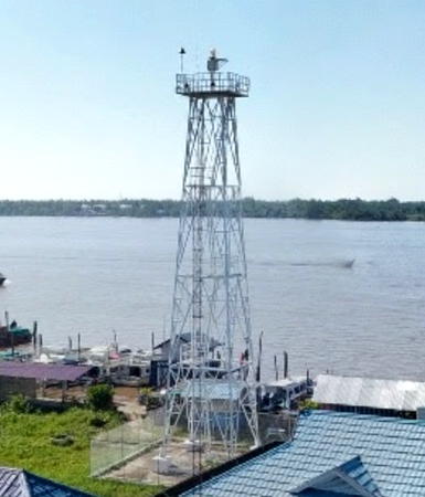
Date unknown. Active; focal plane about 20 m (66 ft); white flash every 5 s. Approx. 17 m (56 ft) square white skeletal tower. NGA has 10 m (33 ft) for the tower height but the light is clearly much taller. Ade Arshavin's 2021 street view is at right, Rony Gusman has a 2021 photo, the lighthouse is at the right edge of photo by Fazlur Rahman Lubis, Cipto Alfatih has an evening drone view, and Google has an indistinct satellite view. Tembilahan, the capital of Indragiri Hilir Regency, is a city of about 70,000 residents on the north side of the Indragiri River. Located in the port area at Tembilahan. Site open, tower closed. Admiralty Q0981.5; NGA 22716.
Kuala Enok North
Date unknown. Active; focal plane 13 m (43 ft); green flash every 6 s. 13 m (43 ft) square green skeletal tower on a platform supported by piles. A distant view is available and Bing has a satellite view. NGA calls this the "West beacon," which seems inaccurate. Located on the north side of the entrance to the Enok River. Accessible only by boat. Site open, tower closed. Admiralty Q0980.5; NGA 22722.2.
Kuala Enok No. 5
Date unknown. Active; focal plane about 12 m (39 ft); green light, pattern unknown. Approx. 12 m (39 ft) tower on a platform supported by piles. No photo available but Bing has a satellite view. Located on the north side of the entrance to the Enok River about 8 km (5 mi) west of the Kuala Enok North light. Accessible only by boat. Site open, tower closed. Admiralty Q0980.8.
Kuala Enok South
Date unknown. Active; focal plane 13 m (43 ft); red flash every 5 s. 13 m (43 ft) square red skeletal tower on a platform supported by piles. No photo available but Google has a satellite view. Located on the south side of the entrance to the Enok River. Accessible only by boat. Site open, tower closed. Admiralty Q0980.4; NGA 22722.

Tembilahan Light, Tembilahan, April 2021
Google Maps street view by Ade Arshavin

Information available on lost lighthouses:

Notable faux lighthouses:

Adjoining pages: North: Northern Riau | Northeast: Malaysia: Malaya South Coast | East: Karimun and Batam | South: Southeastern Sumatra

Return to the Lighthouse Directory index | Ratings key

Posted April 13, 2006. Checked and revised March 19, 2025. Lighthouses: 29. Site copyright 2025 Russ Rowlett and the University of North Carolina at Chapel Hill.