Lighthouses of Indonesia: Southwestern Sumatra

Indonesia is a huge country of Southeast Asia, stretching along both sides of the Equator for more than 46 degrees of longitude (roughly 5100 km or 3200 miles). It occupies 17,504 islands, by official count, including more than 6000 inhabited islands. It is the world's fourth most populous nation with a population currently estinated at about 280 million. More than half of the population lives on the island of Java. Other major islands include Sumatra in the west, Borneo (shared with Malaysia and Brunei) in the northwest, Sulawesi in the northeast, and the eastern half of New Guinea in the far east. Other well known islands include Bali, Lombok, Sumbawa, Flores, and Timor (shared with independent East Timor) along the south side of the country.

The unification of the country was accomplished over many years of struggle by Dutch colonial authorities. The Dutch East India Company was founded in 1602 to establish and extend Dutch administration, and after the company folded in 1800 the Netherlands established the Dutch East Indies colony and gradually extended its boundaries to include the present territory of Indonesia. During World War II Japan occupied the islands from March 1942 to the end of the war in 1945. The Republic of Indonesia proclaimed its independence immediately after the war ended and following some conflict the Netherlands accepted the country's independence in 1949.

Sumatra (Sumatera in Indonesian) is the world's sixth largest island and the westernmost of the major islands of Indonesia. It is separated from Malaysia to the north by the Malacca Strait, from Kalimantan (Borneo) to the northeast by the broad Karimata Strait, and from Java to the southeast by the Sunda Strait. Its south coast faces the open Indian Ocean.

Indonesia is divided into 38 provinces (provinsi) and the provinces are subdivided into county units called regencies (kabupaten). Sumatra includes eight of the provinces. This page includes lighthouses in Bengkulu Province. Long and narrow, Bengkulu extends along the southwestern coast of Sumatra for about 525 km (330 mi). The province has a population of about 2.1 million.

More than 700 languages are spoken in Indonesia. The official national language, Indonesian (Bahasa Indonesia), was standardized from a form of Malay that served as a lingua franca across the archipelago. In Indonesian a lighthouse is a mercusuar or a menara suar. Tanjung is a cape, ujung is a headland or point of land, bukit is a hill, sungai is a river, kuala or muara is an estuary or river mouth, pulau is an island, karang is a reef, batu is a rock, laut is a sea, selat is a strait, teluk is a bay, pelabuhan is a harbor, and labuhan is a port.

Aids to navigation in Indonesia are operated and maintained by the Directorate of Marine Navigation within the Directorate General of Sea Transportation.

ARLHS numbers are from the ARLHS World List of Lights. Admiralty numbers are from volume Q of the Admiralty List of Lights & Fog Signals. U.S. NGA List numbers are from Publication 112.

General Sources
Lighthouses in Indonesia
Photos by various photographers available from Wikimedia; most of the photos are historic.
World of Lighthouses - Indonesia
Photos by various photographers available from Lightphotos.net.
Online List of Lights - Indonesia - Sumatra
Photos by various photographers posted by Alexander Trabas.
GPS Nautical Charts
Navigational chart information for southeastern Sumatra.

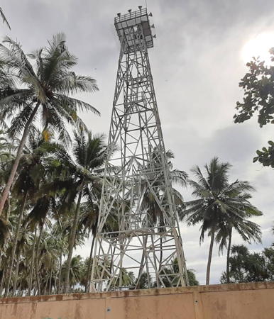
Tanjung Bandar Light, Bintuhan, SFebruary 2021
Google Maps photo by DISNAV_TPK Seksie
Enggano Island Lighthouse
Enggano is a substantial island in the Indian Ocean, measuring roughly 30 km by 15 km (19 mi by 9 mi), about 100 km (60 mi) west of Krui. The southernmost territory of the province, it has a population of about 4100 but is rarely visited. Administratively it is a district of the North Bengkulu Regency although it is quite remote from the rest of that jurisdiction.

Pulau Enggano (Malakoni)
Date unknown. Active; focal plane 60 m (197 ft); four white flashes every 20 s. 40 m (131 ft) square white skeletal tower. No photo available but Google has a satellite view. Located on the southeast side of Malakoni, a small ferry port on the east coast of Enggano. Site probably open, tower closed. ARLHS IDO-197; Admiralty Q0895; NGA 23101.
[Pelabuhan Malakoni]
Date unknown. Active; focal plane 12 m (39 ft); white flash every 5 s. 12 m (39 ft) mast on a square platform supported by piles. Aldi Rahmayadi has a photo, Muhammad Ishaq has a distant view, the light is also seen in a short video by Agus Zuldi Hermawan, and Bing has a satellite view. Located about 200 m (220 yd) north of the pier at Malakoni. Accessible only by boat. Site open, tower closed. Admiralty Q0895.4; NGA 23101.5.

Kaur Regency Lighthouses
Tanjung Linau
Date unknown. Active; focal plane 30 m (98 ft); three white flashes every 15 s. Approx. 23 m (75 ft) square pyramidal skeletal tower, probably with lantern and gallery, painted white. No photo available but Google has a satellite view. Located on a promontory in southernmost Bengkulu province about 1 km (0.6 mi) south of the village of Linau. Site status unknown. Admiralty Q0900; NGA 23098.
Tanjung Bandar (Bintuhan)
Date unknown. Active; focal plane 18 m (59 ft); white flash every 3 s. 16 m (52 ft) square pyramidal skeletal tower painted white. The regional Navigation District has the 2021 photo at the top of this page, taken during an inspection visit in February 2021.A 2016 photo is available, Zoni Heriantoni has a photo, Ipung Ajo has a photo of the stairway inside the tower, and Google has a very fuzzy satellite view. Apparently this is a relatively new light since it is not seen in a 2015 street view. Located on a promontory about 1 km (0.6 mi) south of Bintuhan. Site status unknown. ARLHS IDO-294; Admiralty Q0898; NGA 23099.

South Bengkulu Regency Lighthouse
Mana (Tanjung Manna)
Date unknown. Active; focal plane 30 m (98 ft); three white flashes every 15 s. Approx. 23 m (75 ft) skeletal tower with gallery, painted white. Google has a street view and Google has a satellite view. Located beside a street at the south end of Mana, the capital of the South Bengkulu Regency. Site open, tower closed. Admiralty Q0897; NGA 23100.

Bengkulu City Lighthouse
* Pulaubaai West Breakwater (Lentera Hijau)
Date unknown. Active; focal plane 14 m (46 ft); green flash every 3 s. 9 m (30 ft) round barbell-shaped green tower. Arahim bin Amin Jaya has a photo (also seen at right), Hari Wibawa has a 2019 photo, Muhammad Sabri has a 2022 closeup, and Google has an indistinct satellite view. Pulaubaai is a lagoon converted into a harbor about 15 km (9 mi) south of central Bengkulu. Located on the east breakwater of the dredged entrance to the harbor. Accessible by walking the pier. Site open, tower closed. Admiralty Q0885; NGA 23102.4.
* Pulaubaai Range Front
Date unknown. Active; focal plane 8 m (26 ft); quick-flashing white light. 8 m (26 ft) round white concrete tower with gallery. Google has a street view and a satellite view. Located on the south shore of the Pulaubaai harbor. Site open, tower closed. Admiralty Q0885.5; NGA 23102.
* Pulaubaai Range Rear
Date unknown. Active; focal plane 12 m (39 ft); white flash every 3 s. 12 m (39 ft) round white concrete tower with double gallery. Edhi Sucahyo has a photo and Google has a street view and a satellite view. Located 270 m (885 ft) southeast of the front light. Site open, tower closed. Admiralty Q0885.51; NGA 23102.2.
* Pulaubaai East Breakwater (Lentera Merah)
Date unknown. Active; focal plane 14 m (46 ft); red flash every 2 s. 9 m (30 ft) round barbell-shaped red tower. Kukuh Ribudiyanto has a photo, Rendi Febriyanto has a photo, and Google has an indistinct satellite view. Located on the west breakwater of the dredged entrance to the harbor. Accessible by walking the pier. Site open, tower closed. Admiralty Q0885.2; NGA 23102.6.

West Breakwater Light, Pulaubaai, August 2015
ex-Google Plus photo by Arahim bin Amin Jaya
* Pulau Tikus (3?)
Date unknown (station established 1883). Active; focal plane 33 m (108 ft); white light, 5 s on, 5 s off. 30 m (98 ft) tapered square skeletal tower with gallery, painted white, centered on a square 1-story keeper's house. Edy Prayekno's 2017 aerial photo is at right, Bayu Plundu has a 2018 photo, a page for the island has several photos, and Google has a satellite view. Forand has a distant postcard view of what is believed to be the second tower. The light station is reported to be staffed. Note: There is another Pulau Tikus lighthouse in West Malaysia. Located on a tiny island about 10 km (6 mi) southwest of Bengkulu; boat transportation to the island can be hired in Bengkulu. Accessible only by boat. Site open, apparently it is possible to climb the tower. ARLHS IDO-254; Admiralty Q0884; NGA 23104.

North Bengkulu Regency Lighthouse
Serengai
Date unknown. Active; focal plane 21 m (69 ft); white flash every 5 s. Approx. 12 m (39 ft) square white skeletal tower. No photo available but Google has an indistinct satellite view. The focal plane appears to be higher than listed. Located on a hillside above the village of Serengai. Site status unknown. Admiralty Q0883.8; NGA 23112.
Pulau Mega (Pulau Mego)
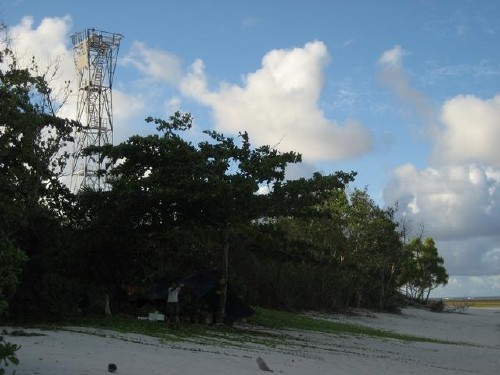
Date unknown (clearly recent). Active; focal plane 33 m (108 ft); white flash every 10 s. 30 m (98 ft) skeletal tower with gallery, painted white. The island is the site of a tectonic monitoring station installed in 2008 by Caltech University in a project aimed at measuring tectonic strains in this earthquake-prone area. Caltech posted a photo but the tower is hidden by trees in Google's satellite view of the station. This light warns vessels away from the south end of reefs extending southeastward from the Mentawai Islands. Located on a small island about 160 km (100 mi) west southwest of Bengkulu. Accessible only by boat. Site status unknown. Admiralty Q0883.95; NGA 23101.7.

Pulau Tikus Light, Bengkulu, April 2017
Google Maps photo by Edy Prayekno

Mukomuko Regency Lighthouse
* Mukomuko (Muko-Muko)
Date unknown. Active; focal plane 25 m (82 ft); white flash every 5 s. Approx. 23 m (75 ft) skeletal tower, painted white. Google has a satellite view and a very distant street view. Located near the Mukomuko airport, at the northern end of Bengkulu province. Site status unknown. Admiralty Q0884.7; NGA 23128.

Information available on lost lighthouses:

Notable faux lighthouses:

Adjoining pages: Southeast: Southern Sumatra | Northwest: Western Sumatra

Return to the Lighthouse Directory index | Ratings keyEdy Prayekno

Posted April 13, 2006. Checked and revised April 3, 2025. Lighthouses: 12. Site copyright 2025 Russ Rowlett and the University of North Carolina at Chapel Hill.