Lighthouses of India: West Bengal

The Republic of India (Bhārat in Hindi) is the seventh largest country and most populous country in the world. It occupies a subcontinent of Asia that projects southward into the North Indian Ocean, separating the Bay of Bengal on the east from the Arabian Sea on the west. Before 1947 it was a patchwork of regions governed as British colonies and semi-independent princely states under British supervision. In 1947 this British Raj was partitioned into the independent states of India and Pakistan. Several French and Portuguese colonies embedded in the territory of India were absorbed in 1950 and 1961, respectively.

India is a federal union comprising 28 states and 8 union territories. This page lists lighthouses of the state of West Bengal on India's northeast coast This coastline faces the head of the Bay of Bengal and is almost everywhere low and sandy, with numerous offshore shoals. The major port is Kolkata (Calcutta) on the Hooghly River, the major western distributary of the Ganges Delta at the head of the Bay.

India's lighthouse heritage is British. However, only a fraction of the original British lighthouses remain in use; new towers have been built at most of the stations. India has also built many lighthouses at new locations in recent years. Nearly all of the larger Indian lighthouses are staffed and by long tradition the staff will receive visitors at a specific time, usually late in the afternoon. Several lighthouses have been developed as tourist attractions and have longer hours.

Hindi and English are official languages in India, with English serving as a lingua franca for the entire nation. The Indian Constitution recognizes another 21 languages, called scheduled languages, and each of the coastal states has its own scheduled language in official use. In Bengali, the official language of West Bengal, the word for a lighthouse is bātighara (বাতিঘর); dbīpa or dwip is an island, nadī is a river, and bandara is a port or harbor. In Odia, the official language of Odisha, the English word "lighthouse" is transliterated as linhathausē (ଲିଂହଥୌସେ).

Lighthouses and aids to navigation in India are administered by the Directorate General of Lighthouses and Lightships (DGLL), an agency of the Ministry of Shipping. Lighthouses of West Bengal and Odisha are maintained by the Kolkata Directorate of DGLL.

ARLHS numbers are from the ARLHS World List of Lights. Admiralty numbers are from volume F of the Admiralty List of Lights & Fog Signals. U.S. NGA List numbers are from Publication 112.

General Sources
Aids to Navigation - Kolkata Region
Lighthouse information from DGLL, including photos for most of the lighthouses.
World of Lighthouses - India
Photos by various photographers available from Lightphotos.net.
Lighthouses in India - West Bengal
Photos by various photographers available from Wikimedia.
Online List of Lights - India - Bay of Bengal
Photos by various photographers posted by Alexander Trabas.
World Lights - India
Historic postcard images posted by Michel Forand.
Leuchttürme Asiens auf historischen Postkarten
Historic postcard images posted by Klaus Huelse.
Google Maps
Satellite view of the West Bengal coast.


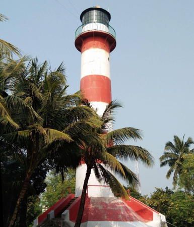
Dariapur Light, Contai, West Bengal, December 2023
Google Maps photo by Dr. Sayan Pradhan
Lighthouses of West Bengal

South 24 Pardenas District (East Side Hooghly Estuary) Lighthouse
* Sagar Island (Saugor, Middleton Point) (3)
1909 (station established 1821). Active; focal plane 26 m (85 ft); white flash every 3 s. 23 m (79 ft) round cast iron tower, painted with horizontal red and white bands. The base of the lighthouse is surrounded by a square pyramidal observation platform of recent construction. A 2019 photo by Sandip Kumar Jana is at right, Nishant Kumar has a 2021 photo, Dipak Das has a 2017 photo, Santanu Sen has a 2023 photo, Partho Sarothi Mitra has a 2021 drone view, Huelse has a historic postcard view, and Google has a satellite view. The second lighthouse (1852) was also a cast iron tower. Ownership was transferred to DGLL from the Kolkata Port Trust in 2011. The present lighthouse has a very attractive setting in the center of a square reservation, surrounded by a moat and buildings now used for offices. In 2015 the lighthouse was identified for future tourist development. Located at Middleton Point on Sagar Island, marking the east side of the entrance to the Hooghly estuary and Kolkata (Calcutta). The island is accessible by ferry; it is a pilgrimage site, being the place where the Ganges meets the sea. Site open, tower closed but visitors can climb the observation platform. ARLHS IND-060; Admiralty F1028; NGA 26860.
Diamond Harbour (?)
Date unknown (station established 1898). Active; focal plane unknown; quick-flashing white light. The light lists do not describe this light. The listed location, also charted by C-Map, is at or near the Diamond Harbor passenger ferry terminal. Pradipta Jana's photo of the ferry wharf shows a tall mast rising from a square base about 6 m (20 ft) tall; this is a possible location for the light. Google has an indistinct satellite view. Diamond Harbour is on the east side of the Hooghly on the southern edge of the Kolkata metropolitan area. It has no port facilities but it was a protected anchorage for ships waiting to proceed to the city's docks. In 1904 the light was listed with a focal plane of 14 m (46 ft). A note is in order here concerning persistent reports of a historic Diamond Harbour lighthouse. Numerous Indian web sites repeat the claim that there is an "old lighthouse" close to a ruined Portuguese fort in Diamond Harbour. The fort ruins are real but they have washed into the river in recent years. A frequently posted historic engraving of a "Diamond Point" lighthouse is almost certainly an image of the lost Cowcolly (Kaukhali) lighthouse on the other side of the estuary. As best one can determine there was never a European-style light station at Diamond Harbour (nor would there have been a need for one). Assuming the light is at the ferry terminal: site open, tower closed. Admiralty F1035; NGA 26892.

Sagar Island Light, Sagar Island, July 2019
Google Maps photo by Sandip Kumar Jana

Purba Medinipur (East Midnapore) District (West Side Hooghly Estuary) Lighthouses
Navigation on the Hooghly is traditionally guided by a series of tall stone beacons. The Admiralty formerly listed some of them as lighted, but many of those listings have been deleted. Of those still listed, most cannot be found in satellite views. The Directory is listing only these three towers that are charted as active and for which photos are available. There are several other lighted aids charted along the shores of the river but no photos or decriptions of them are available.

Panchpara Range Rear (1 and 2)
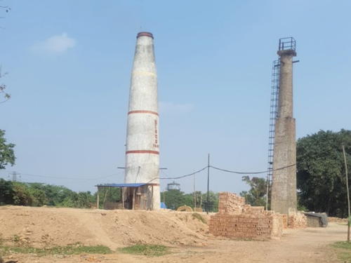
Date unknown. Active; focal plane about 25 m (82 ft); white flash every 1.5 s. Approx. 20 m (66 ft) tower, lower half square and upper half round. Timir Baran Saha has the 2023 photo at right, Manoj Parui also has a 2023 photo, and Google has a satellite view. The original tower does not appear to be lighted but the new tower may be. This is a leading light guiding ships in both directions on the river. Located in the Bisco Bricks Field, a brick manufacturing yard in the Hatgatccha neighborhood on the west side of the Hooghly. Site status unknown. Admiralty F1043.61.
* Uluberiya Reach Range Rear
Date unknown. Active (?); focal plane about 25 m (82 ft); white flash every 10 s. Approx. 22 m (72 ft) 2-stage tower, lower half square and upper half round. Subhrajit Chatterjee has a 2022 photo and Google has a satellite view. This is a downstream (southbound) range. Located on the west bank of the Hooghly south of Uluberiya. Site status unknown. Admiralty F1035.91.
* Sandia Column
Date unknown. Inactive but charted and listed with 17 m (56 ft); white flash every 10 s. Approx. 14 m (43 ft) round column originally painted with black and white horizontal bands, Google has a street view and a satellite view. Located on the west side of the Hooghly opposite Nayachar Island. Site open, tower closed. Admiralty F1031.45; NGA 26862.

New (left) and old Panchpara Range Rear Lights, Kolkata, March 2023
Google Maps photo by Timir Baran Saha
** Dariapur (2)
1968 (station established 1943). Active; focal plane 30 m (98 ft); two long (1.4 s) white flashes every 20 s. 26 m (85 ft) round cylindrical concrete tower with lantern and gallery, painted with horizontal black and white bands. Sayan Pradhan's 2023 photo is at the top of this page, Wikimdia has Biswarup Ganguly's 2016 photo and several other photos, a 2012 photo is available, and Google has a 2023 street view and a satellite view. The original light was on a 20 m (66 ft) steel mast located 1 km (0.6 mi) to the east. The original optics for the current lighthouse were transferred from the 1881 Dwarka lighthouse, deactivated in 1964. Modern LED optics are now in use. Since 1995 the lighthouse has also carried a racon (radar receiver-transmitter). Listed as a tourist attraction, this lighthouse is open for climbing. In 2015 it was identified for future tourist development. About 8 km (5 mi) northeast of this station is the location of the Cowcolly Light, built in 1810 and active until the 1920s. Located near Contai (Kanthi) on the west side of the entrance to the Hooghly estuary and Kolkata (Calcutta), about 8 km (5 mi) northeast of Janput. Site open, tower open late afternoons daily except Sunday. ARLHS IND-030; Admiralty F1029; NGA 26861.
** Tajpur
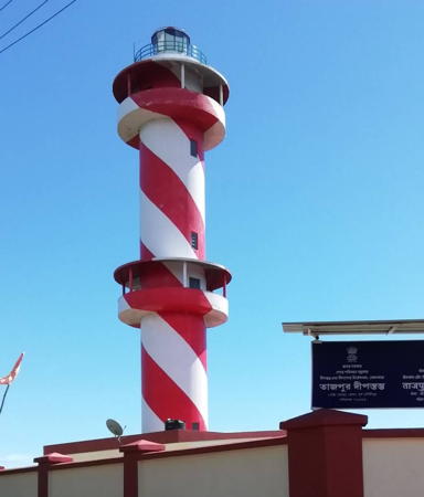
2019. Active; focal plane 30 m (98 ft); three white flashes every 15 s. Approx. 27 m (89 ft) round cylindrical concrete tower with lantern and two large observation galleries. A 2020 photo is at right, Suvajit Manna has a good photo, T. Suman has a closeup and a street view, and Google has a satellite view. Located in Tajpur, about 30 km (19 mi) southwest of Contai. Site open, tower open late afternoons daily. . Admiralty F1028.5.

Information available on lost lighthouses:

  • Cowcolly (Kaukhali) (1810-1940s?), Purba Medinipur District, West Bengal. This was a round brick tower, 27 m (88 ft) tall. It was the first British-built lighthouse in India. The lighthouse was deactivated in the 1920s but is still mentioned in U.S. sailing directions as late as 1941. Oddly, despite its long life extending into the 20th century no photos of it have been found. However, Wikimedia's engraving of a lighthouse identified as "Diamond Point" is almost certainly an image of the Cowcolly lighthouse. The original of this well-known engraving is captioned "Diamond Point, the entrance to the port of Calcutta." This has led many to believe that the lighthouse must have been near Diamond Harbour, but there was never a large lighthouse in that area during the 19th century and Diamond Harbour is many miles above the entrance to the Hooghly. The Cowcolly lighthouse was on the west side of the Hooghly, northwest of Sagar Island, where it did indeed mark the the entrance to the port of Calcutta. Google has a satellite view of the area. The fate of the historic lighthouse is not known but apparently nothing remains of it. ARLHS IND-028.

Notable faux lighthouses:


Tajpur Light, Tajpur, October 2020
Google Maps photo by ripon sk

Adjoining pages: East: Bangladesh | Southeast: Odisha

Return to the Lighthouse Directory index | Ratings key

Posted January 20, 2006. Checked and revised August 10, 2025. Lighthouses: 7. Site copyright 2025 Russ Rowlett and the University of North Carolina at Chapel Hil