Lighthouses of South Korea: Yeosu

For most of its history Korea was an independent kingdom, or at least an autonomous kingdom under Chinese influence. This came to an end in 1910 when Japan annexed all of Korea. At the end of World War II in 1945 the 38° parallel was established as the dividing line between U.S. and Soviet zones of occupation, and in 1948 separate civil administrations were established in the two halves of the country. The Korean War (1950-53) ended in a draw with the armistice line falling close to the prewar 38° line. The Republic of Korea (ROK; 대한민국, Daehan Minguk in Korean), commonly called South Korea, occupies the Korean peninsula south of the armistice line.

The name Korea, used internationally, is a Western version of Goryeo or Koryŏ (고려), the name of a kingdom that unified the country in the tenth century. From 1392 to 1897 the kingdom was known instead as Joseon or Chosŏn (조선). Today South Koreans usually call their country Hanguk (한국, literally "one country") and the official name of the Republic of Korea is Daehan Minguk (대한민국).

South Korea is divided into eight provinces and nine province-level cities. This page is one of three pages covering lighthouses of the municipal city of Yeosu, a major port in southeastern Jeollanam (South Jeolla) province. Yeosu is located in the central part of Korea's south coast. The city occupies the Yeosu peninsula and includes several hundred islands of all sizes, 49 of them inhabited. The population of the city proper is only about 275,000 but the port has developed rapidly as an alternative to Busan.

This page includes lighthouses of Yeosu City (the urbanized area) and the Town of Dolsan, which occupies the island of Dolsando just to the south. The Yeosu South page includes lighthouses of South Township and Hwayang Township, which occupy islands farther south. Yeosu also administers the islands of Samsan Township, located in the Korea Strait southwest of the Yeosu Peninsula. Lighthouses of these islands are described on the Samsan Islands page.

Navigational aids in the ROK are regulated by the Ministry of Oceans and Fisheries (MOF). The lights on this page are maintained by the Yeosu Regional Oceans and Fisheries Administration.

In 2000 South Korea adopted a Revised Romanization System to replace systems formerly used in the West. In the Revised System, the word for a lighthouse is deungdae (등대); dan (formerly tan) is a cape, seom (som) or do (to) is an island, am or amseog is a rock, man is a bay, and hang is a harbor. Some place names may be more familiar to Westerners in the spellings of older systems.

ARLHS numbers are from the ARLHS World List of Lights. KR numbers, where available, are from the Korean light list. Admiralty numbers are from volume M of the Admiralty List of Lights & Fog Signals. U.S. NGA

General Sources
World of Lighthouses - South Korea
Photos by various photographers available from Lightphotos.net.
Online List of Lights - Korea
Photos by various photographers posted by Alexander Trabas.
Navionics Charts
Navigation chart for the Yeosu area.


Odongdo Light, Yeosu
Yeosu Port Office photo
Yeosu City Lighthouses

Gwangyang Harbor Lighthouses
Gwangyang (Kwangyang) Passage
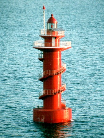
1999. Active; focal plane 18 m (59 ft); two white flashes every 5 s. 24 m (79 ft) round cylindrical concrete tower with lantern and double gallery, painted with red and black horizontal bands. Access to the galleries is by an external stairway the spirals around the tower. Jürgen Klinksiek's photo at right shows the earlier appearance of the lighthouse in all red. Bing has a satellite view. Located in the entrance to the industrial harbor of Gwangyang, off the eastern end of the island of Myodo, about 20 km (13 mi) north of Yeosu. Accessible only by boat. Site status unknown. KR-2405; Admiralty M4310.82; NGA 17200.8.
Dunpyeongtan (Tunpyeongtan)
2005. Active; focal plane 13 m (43 ft); two white flashes every 5 s. 10 m (33 ft) octagonal concrete tower, painted black with one red horizontal band, mounted on a round concrete pier. Google and a very distant street view from shore and Bing has a satellite view. Located on a small island about 1200 m (3/4 mi) off the east coast of the Yeosu Peninsula, halfway between Gwangyang and Yeosu harbors. Accessible only by boat. Site status unknown. KR-2450; Admiralty M4310.63; NGA 17123.

Main Harbor Lighthouses
* Yeosu New Port West Breakwater
Around 2018. Active; focal plane about 15 m (49 ft); red light, pattern unknown. Approx. 12 m (39 ft) round red tower. Giho Ong has a closeup 2020 photo, Dave Shin has a 2023 photo, Hayul Hai has a distant street view from the East Beakwater, and Google has a satellite view. This is a new breakwater built about 2018. Located at the end of the west breakwater of the harbor. Accessible by walking the pier. Site open, tower closed. KR-2436.7; Admiralty M4310.4.
* Yeosu New Port North Breakwater (2)
2010 (station established 1992). Active; focal plane 12 m (39 ft); red flash every 4 s. 10 m (33 ft) round concrete tower, shaped like a torch, mounted on a concrete base. Entire lighthouse is red. Hayul Hai has a 2018 closeup photo, Lightphotos/net has another photo, and Google has a satellite view. The decorative north and east breakwater lighthouses were built as part of the upgrades to the waterfront prior to the 2012 World's Fair in Yeosu. The original lighthouse was a plain red cylindrical tower. Located at the end of the north breakwater of the harbor, off the waterfront of the Expo 2012 world's fair site. Accessible by walking the pier. Site open; visitors can climb to an observation platform near the base of the tower. KR-2436; Admiralty M4310.3; NGA 17126.
* Yeosu New Port East Breakwater (2) (?)
2010. Active; focal plane 13 m (43 ft); green flash every 4 s. Entire lighthouse is white. K.T. Park has a 2023 photo, a black and white 2012 view from the harbor is available, Kim Cheol Bong also has a view from the harbor, Hayul Hai has a closeup street view, and Google has a satellite view. Located at the end of the breakwater extending northward from Odongdo. Accessible by walking the pier. Site open, tower closed. KR-2453.5; Admiralty M4310.1 (ex-M4310.4); ex-NGA 17128.
Kwangyang Passage Light
Gwangyang Passage Light, Yeosu, January 2000
photo copyright Jürgen Klinksiek; used by permission
*** Odongdo (Yeosu) (3)
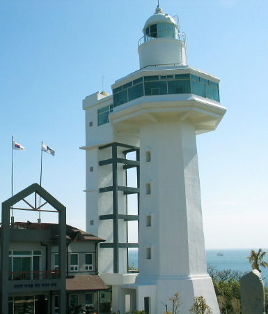
2002 (station established 1913). Active; focal plane 61 m (200 ft); white flash every 10 s. 27 m (82 ft) octagonal concrete tower with lantern, gallery, and a large octagonal observation deck about 3/4 of the way up the tower. A square cylindrical secondary tower, connected by a bridge to the observation deck, has an elevator providing visitor access to the deck. Entire structure painted white. A 2-story building connected to the lighthouse was the public information center for the 2012 World's Fair in Yeosu. A photo is at the top of this page, Park Min-hyuk has a 2020 photo, a 2008 photo and another closeup are available, Jinwoo Kim has a 2022 photo, Wikimedia has a distant view from the sea, Chang Hyun-wook has a closeup street view, and Google has a satellite view. This modern lighthouse replaced a 10.5 m (34 ft) tower built in 1952 during the Korean War. The lantern and lens of that lighthouse are displayed outside the current lighthouse. We need information on the 1913 lighthouse, which was listed in early light lists as "Reisu Gulf" with a focal plane of 45.5 m (149 ft). Odongdo is an island about 500 m (0.4 mi) in diameter that partly shelters the harbor of Yeosu. The island is connected to the mainland by a broad breakwater and causeway about 800m (0.5 mi) long. Located on the highest point of the island, commanding a sweeping view of the bay and islands in the vicinity. Site open; observation deck open daily. ARLHS SKR-018; KR-2451; Admiralty M4310; NGA 17116.
Yangam (Yang-Am)
1986. Active; focal plane 13 m (43 ft); two white flashes every 10 s. 17 m (56 ft) round cylindrical concrete tower with double gallery, mounted on a round concrete pier. Lighthouse painted black with one broad red horizontal band. Google has a satellite view. Located on a shoal about 800 m (1/2 mi) east of the Odongdo lighthouse. Accessible only by boat, but there must be a good view from Odongdo. Site open, tower closed. KR-2452; Admiralty M4309.8; NGA 17120.
* Yeosu Old Port Hamel Breakwater (Hamel Lighthouse)
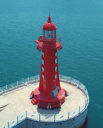
2005. Active; focal plane 14 m (46 ft); red flash every 5 s. 10 m (33 ft) round cylindrical concrete tower with lantern, gallery, and four ribs. Lighthouse painted red. A 2017 drone view is at right, Lucie Zidkova has a photo, a 2022 photo, a 2017 photo are available, and Google has a satellite view. The lighthouse recognizes Hendrick Hamel, a Dutch sailor shipwrecked near Yeosu in 1653 with 35 crewmates; he lived in Korea for 13 years and later wrote a book about his adventures. Located at the end of a short breakwater on the north side of Yeosu harbor. Readily accessible by walking the pier. Site open, tower closed. KR-2462; Admiralty M4310.52; NGA 17135.
* Yeosu Gu Hang (Yeosu Old Port) (2)
2018 (station established 1981). Active; focal plane 10 m (33 ft); green flash every 4 s. 7 m (23 ft) round white fiberglass tower attachjed to a round 1-story equipment shelter. Peter Lee has a photo and Google has a distant satellite view. Located at the end of a short pier on the north side of Yeosu harbor. Site status unknown, but the light is easily seen from the quay. KR-2464; Admiralty M4310.54; NGA 17140.
Janggundo (Changgundo)
1986. Inactive since 2018. 10 m (33 ft) octagonal white concrete tower. Kim Won-dong has a night time photo, a view from the harbor is available, and Google has a distant and fuzzy satellite view. Located at the northwestern corner of Janggungdo, an island in the center of Yeosu's harbor. Accessible only by boat. Site open, tower closed. ex-KR-2465; ex-Admiralty M4310.57; NGA 17136.
Gukdong Hang Detached Breakwater East End
Date unknown. Active; focal plane 12 m (39 ft); yellow flash every 6 s. 9 m (30 ft) square concrete tower. Entire lighthouse is yellow. drone view (lighthouse at the extreme left edge) is available and Google has an indistinct satellite view. Located at the east end of a breakwater at Gukdong Hang, the traditional western port of Yeosu. Accessible only by boat but easily seen from shore. KR-2482.6; Admiralty M4308.66.
Gukdong Hang Detached Breakwater West End
Date unknown. Active; focal plane about 12 m (39 ft); red light, pattern unknown. Approx. 10 m (33 ft) concrete tower. Entire lighthouse is red. Deokchan Yoon has a photo, a more distant view and a drone view (lighthouse on the left) are available, and Google has an indistinct satellite view. Located at the west end of a breakwater at Gukdong Hang, the traditional western port of Yeosu. Accessible only by boat but easily seen from shore. KR-2482.7; Admiralty M4308.67.

Hamel Light, Yeosu, July 2017
Google Maps photo by 쿠키파파
Yado (2)
2009 (station established 1979). Active; focal plane 11 m (36 ft); red flash every 4 s. 10 m (33 ft) octagonal cylindrical concrete tower, painted red. Seo Mi-kyung has a distant street view, a drone view is available (lighthouse on the right), and Google has a satellite view. Yado is a small island opposite Gukdong Hang, the traditional western port of Yeosu. Located on the north side of the island. Accessible only by boat. Site status unknown. KR-2482; Admiralty M4308.72; NGA 17148.

Gawang Bay Lighthouses
Pungnakdo
Date unknown. Active; focal plane 11 m (36 ft); white flash every 6 s. 10 m (33 ft) octagonal white concrete tower. The light is barely visible left of center in a distant view and Google has a satellite view. Located at the west end of a small island about 800 m (1/2 mi) south of Gukdong Hang. Accessible only by boat. Site status unknown. KR-2477.1; Admiralty M4308.735.
Ammokdo (Ammogdo)
Date unknown. Active; focal plane 24 m (79 ft); white flash every 5 s. 7.5 m (25 ft) octagonal white concrete tower. The light is barely visible atop the island at the right edge in a very distant view and Google has a satellite view. Located on a small island at the entrance to Yeosu harbor from the southwest. Accessible only by boat. Site open, tower closed. KR-2477; Admiralty M4308.74; NGA 17152.
Mamuram
2005. Active; focal plane 13 m (43 ft); two white flashes every 10 s. 13 m (43 ft) concrete tower, painted black with one red horizontal band. A small photo is available and Bing has a fuzzy satellite view. Located on a reef on the north side of the entrance to Yeosu harbor from the southwest. Accessible only by boat. Site open, tower closed. KR-2474.9; Admiralty M4308.75; NGA 17211.
Hamji
Date unknown. Active; focal plane 10 m (33 ft); two white flashes every 5 s. 10 m (33 ft) round concrete tower painted black with a red horizontal band. Google has a fuzzy satellite view and a distant 2020 street view. A Korean Notice to Mariners in November 2020 lists the light as green, and it is indeed green in the August 2020 street view, but another Notice to Mariners in July 2021 announced the change to black and red. Located off a small boat harbor in the Songjeon neighborhhod in northwestern Yeosu. Accessible only by boat. Site open, tower closed. KR-2474.13; Admiralty M4308.76.
Yeocho (2)
Date unknown (station established 1967). Active; focal plane 15 m (49 ft); two white flashes every 5 s. 13 m (43 ft) round cylindrical concrete tower, painted black with a red horizontal band and mounted on a round concrete pier. No photo available but Google has a satellite view. Located on a reef about 5 km (3 mi) southwest of Yeosu harbor's west entrance and a similar distance northwest of Dolsando. Accessible only by boat. Site open, tower closed. KR-2475; Admiralty M4308.6; NGA 17212.

Dolsan Town Lighthouses

Dolsando is an island about 15 km (9 mi) long and 10 km (6 mi) wide, located southeast of the Yeosu peninsula. The Dolsan Bridge connects the island to downtown Yeosu. Dolsan Town includes Dolsando and some smaller nearby islands.

East Coast Lighthouses
Uam
Date unknown. Active; focal plane 13 m (43 ft: two white flashes every 5 s. 7 m (23 ft) round concrete tower painted black with one red horizontal band. No photo available but Google has an indistinct satellite view. Located on a shoal about 1.6 km (1 mi) off the northeast coast of Dolsando. Accessible only by boat. Site open, tower closed. KR-2318; Admiralty M4309.4; NGA 17108.
Dolsan (Dolsando, Tolsan, Yeosu Hang)
Date unknown (station established 1944). Active; focal plane 115 m (377 ft); white flash every 5 s. 9 m (30 ft) octagonal white concrete tower with gallery. A photo and a second photo are available and Google has a satellite view. Located on a high hill on the southeast side of the Yeosu harbor entrance. Site status unknown. KR-2467; Admiralty M4309; NGA 17104.
Daedan (Taedan, "Big End Lighthouse")
2001. Active; focal plane 33 m (108 ft); white flash every 4 s. 13 m (43 ft) octagonal cylindrical white concrete tower with gallery. Lee Kwang-ho's photo is at right, Hyokwan Ahn has a lovely closeup, a 2023 photo is available, and Google has an indistinct satellite view. Located on a promontory on the northeast coast of Dolsando, about 4 km (2.5 mi) southeast of the Dolsan lighthouse. Site status unknown. . KR-2467.5; Admiralty M4308.98; NGA 17101.
Bamseom (Pam-som)
Date unknown. Active; focal plane 15 m (49 ft); three quick white flashes every 10 s. 17 m (56 ft) round steel tower painted black with one yellow horizontal band. N. Pham has a 2023 photo, another photo is available (lighthouse on the right), and Google has a satellite view. Located on a shoal off the southeast coast of Dolsando. Accessible only by boat. Site open, tower closed. KR-2467.6; Admiralty M4308.97; NGA 17100.5.
 

Daedan Light, Dolsan, August 2021
Google Maps photo by Lee Kwang-ho
 

South Coast Lighthouses
* Jakgeum Hang
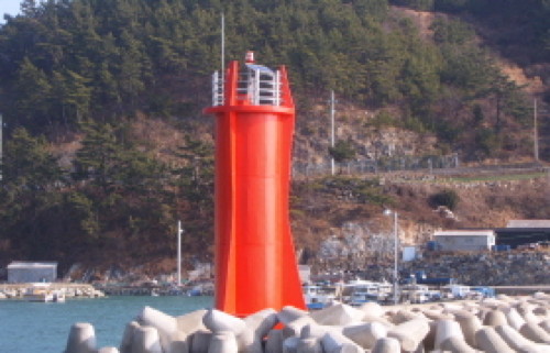
2002. Active; focal plane 14 m (46 ft); red flash every 5 s. 10 m (33 ft) round concrete tower with three decorative ribs, painted red. A photo is at right, another photo and a third photo are available, and Google has a street view and a satellite view. Located on the east breakwater sheltering small boat harbors at the southern end of Dolsando. Accessible by walking the pier. Site open, tower closed. KR-2470.2; Admiralty M4308.45; NGA 17161.
Geumseong (Kumsong)
1986. Active; focal plane 9 m (30 ft); red flash every 6 s. 10 m (33 ft) octagonal concrete tower, painted red. A photo (first photo on the page) and a sunset photo are available and Google has a satellite view. Located on a reef just off the south coast of Dolsando. Accessible only by boat. Site open, tower closed. KR-2470; Admiralty M4308.5; NGA 17160.
Gunnae
2018. Active; focal plane 10 m (33 ft); red flash every 4 s. 10 m (33 ft) round concrete tower, painted red. Google has a satellite view. Located in the approach to Dolsan Hang from Geomodo. Accessible only by boat. Site open, tower closed. KR-2469.12; Admiralty M4308.54.
Dolson Hang West Breakwater
Date unknown. Active; focal plane 14 m (46 ft); green flash every 5 s. 10 m (33 ft) round steel tower with lantern and gallery painted white. Chandler Lee has a 2021 photo and Google has a satellite view. Located on a short breakwater recently built at Dolson Hang. Site status unknown but it should be easy to see the light from the shore. KR-2469.11; Admiralty M4308.57.
Hajeungdo (Hajungdo)
Date unknown. Active; focal plane 10 m (33 ft); red flash every 4 s. 10 m (33 ft) round concrete tower, painted red. Dongsik Kim has a distant view and Google has a satellite view. Located off the southwestern tip of Dolsando. Accessible only by boat. Site open, tower closed. KR-2471; Admiralty M4308.55; NGA 17165.
Jakgeum Hang Light
Jakgeum Hang Light, Dolsan
Yeosu Port Office photo

Information available on lost lighthouses:

Notable faux lighthouses:

Adjoining pages: East: Namhae | South: Yeosu South | West: Goheung Area

Return to the Lighthouse Directory index | Ratings key

Posted January 9, 2008. Checked and revised February 12, 2024. Lighthouses: 27. Site copyright 2024 Russ Rowlett and the University of North Carolina at Chapel Hill.