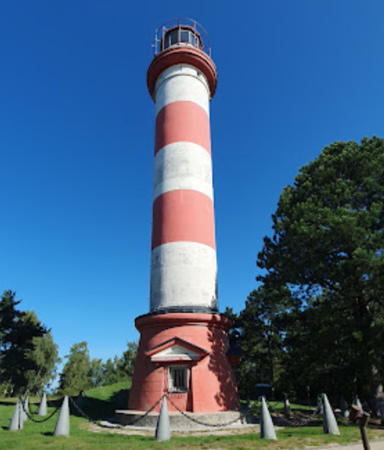
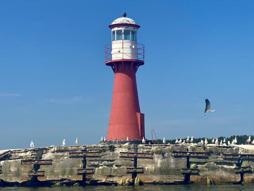
Lighthouses of Lithuania

The Republic of Lithuania (Lietuva in Lithuanian) is located on the southeast side of the Baltic Sea, south of Latvia and north of the Russian exclave of Kaliningrad. The coast of Lithuania is relatively short, extending south to north about 185 km (115 mi). The southern half of the coast features the northern part of the Curonian Spit (Kuršių Nerija) and behind the spit is the broad and shallow lagoon known as the Curonian Sound (Kuršių Marios). The sound empties into the Baltic through a narrow channel at its north end. The country's major port, Klaipėda, is located on this channel.

From the late 18th Century until World War I most of Lithuania was part of the Russian Empire and the coastal regions were part of Prussia and later Germany. Under German rule Klaipėda was known as Memel. Following the war Lithuania asserted its independence in 1918 and occupied Memel and the coastal region in 1923. In World War II the Soviet Union occupied Lithuania and annexed it as one of the socialist republics within the Union. As the collapse of the Soviet Union approached in 1990 Lithuania became the first of the Soviet republics to resume its independence.

Lithuania is divided into ten counties but the entire coastal region is in Klaipėda County. The county is subdivided into seven municipalities.

The Lithuanian word for a lighthouse is švyturys. In Lithuanian sala is an island, ragas is a cape, rifas is a reef, jlanka is a bay, ankštas is a strait, upė is a river, and uostas is a port or harbor. The Baltic Sea is called the Baltijos Jūra in Lithuania.

In the listing the historical German names of the light stations are placed in curly brackets {}.

Coastal and Klaipėda harbor aids to navigation are regulated by the Lithuanian Transport Safety Administration (Lietuvos Transporto Saugos Administracija or LTSA) but since 2001 the actual operation of the lights has been assigned to the Lighthouse and Hydrography Service of the Klaipėda State Seaport (Klaipėdos Uostas). Aids to navigation on the Curonian Sound and Nemunas River system are managed by the Inland Waters Navigation Inspectorate (Valstybinė Vidaus Vandenų Laivybos Inspekcija, or VVVLI).

ARLHS numbers are from the ARLHS World List of Lights. LT numbers are from the Lithuanian light list. Light List numbers are from volume C of the Admiralty List of Lights & Fog Signals. U.S. NGA List numbers are from Publication 116.

General Sources
Lighthouses of Lithuania
Special thanks to Bronius Sriubas for contributing photos of all seven historic Lithuanian lighthouses.
Online List of Lights - Lithuania
Photos of navigational aids, many of them by the Maritime Safety Administration, posted by Alexander Trabas.
Lighthouses in Lithuania
Photos by various photographers available from Wikimedia.
World of Lighthouses - Lithuania
Photos by various photographers available from Lightphotos.net.
Leuchttürme an der litauischen Küste
Photos of Lithuanian lighthouses by Bernd Claußen.
List of Lights
The official Lithuanian light list is available in pdf format.
Leuchttürme der ehemaligen deutschen Ostgebiete
Postcard views of historical German lighthouses of the Baltic posted by Klaus Huelse.
Navionics Charts
Navigational chart for Lithuania.


Nida Light, Curonian Spit, September 2023
Google Maps photo by Hei “Heidiho”
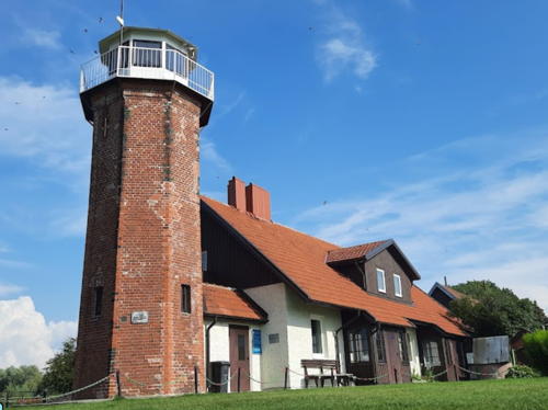
Šilutė District Municipality: Curonian Sound East Shore Lighthouses
** Uostadvaris {Kuwertshof}
1876. Inactive since 1986. 12 m (39 ft) octagonal cylindrical brick tower with lantern and gallery, attached by a covered passageway to a 1-1/2 story brick keeper's house. The buildings are unpainted red brick; lantern and gallery painted white. Indre Snarskyte's 2021 photo is at right, Sriubas has contributed a good photo, Lithuanian Wikipedia has a page with a photo, Wikimedia has additional photos, a photo taken in the lantern room is available, and Google has a street view and a satellite view. Located on the south side of the Atmata River, one of the mouths of the Nemunas (Neman) River, about 12 km (7.5 mi) north of Rusne. Site open, tower open at times but no schedule is available. Owner: unknown. Site manager: Nemunas Delta Regional Park (?). . ARLHS LIT-007.
** Ventės Ragas (Cape Vente) {Windenburger Eck, Windsburg} (2)
1860 (station established 1837). Active; focal plane 13 m (43 ft); continuous white light. 11 m (36 ft) octagonal brick tower with lantern and gallery, attached by a covered passageway to a 1-1/2 story brick keeper's house. The buildings are unpainted red brick; lantern and gallery painted white. Wikimedia has photos, another photo is available, Claußen has a page with several photos, Lithuanian Wikipedia has a page with a photo, Huelse has a historic photo, and Google has a street view and a satellite view. The keeper's house is part of an ornithogical field station and museum, founded in 1929 and well known among birders. The light no longer has any navigational importance, but it is maintained as a historical symbol. Located about 15 km (9 mi) southwest of Kintai at the end of the Sturmai peninsula, which projects into the Curonian Sound. Site open, museum open, tower open to visitors but the schedule is not known. Operator: Inland Waters Navigation Inspectorate. Site manager: Nemunas Delta Regional Park. .ARLHS LIT-008.


Uostadvaris Light, Šilutė District, August 2021
Google Maps photo by Indre Snarskyte


Neringa Municipality: Curonian Spit (Kuršių Nerija) Lighthouses
Recognized as a UNESCO World Heritage Site, the Curonian Spit is 98 km (61 mi) long; the northern 52 km (32 mi) are in Lithuania and the southern 46 km (29 mi) are in Russian Kaliningrad. The Lithuanian section of the spit is organized as the Neringa municipality. The permanent population of Neringa is about 4000.

**
Nida {Nidden} (2)
1953 (station established 1874). Active; focal plane 76 m (249 ft); two white flashes every 5.8 s. 29 m (95 ft) round cylindrical concrete and steel tower with lantern and gallery, painted with red and white horizontal stripes. The original Fresnel lens (transferred from the 1874 tower) is displayed in a museum as part of the station. A 2023 photo is at the top of this page, Trabas has LTSA's excellent photo, Lithuanian Wikipedia has a page with a current photo and a historic photo, a 2021 photo is available, and Google has a street view and a satellite view. Huelse has a postcard view of the original lighthouse, which was heavily damaged during World War II. Although it was patched up after the war, it was decided to replace it with a taller tower. Nida, a popular seaside resort, is on the east side of the Curonian Spit not far north of the Russian border. The lighthouse is located on a hill called Urbo Kalnas west of town, in the center of the peninsula. Accessible by car. Site open; tower reported to be open at times but information is needed on the schedule. Operator: Klaipėda State Seaport. Site manager: Kuršių Nerija National Park. . ARLHS LIT-004; LT-0050; Admiralty C3318; NGA 11984.
* Nida Marina South Breakwater
Date unknown. Active (privately maintained); focal plane about 10 m (33 ft); red light, pattern unknown. Approx. 7 m (23 ft) round concrete tower painted with red and white horizontal bands. A photo and a photo of both breakwater lights are available and Google has a street view and a distant satellite view. Located on the main breakwater of the marina at Nida. Accessible by walking the pier. Site open, tower closed.
* Nida Marina North Breakwater
Date unknown. Active (privately maintained); focal plane about 10 m (33 ft); green light, pattern unknown. Approx. 7 m (23 ft) round concrete tower painted with green and white horizontal bands. Mantas Brazdžionis has a photo also showing the south breakwater light and Google has a street view and a distant satellite view. Located on the main breakwater of the marina at Nida. Accessible by walking the pier. Site open, tower closed.
Pervalka {Pferdehaken, Perwelk} (2)
1948 (station established 1900). Inactive but maintained as a daybeacon. 14 m (46 ft) round cast iron tower, painted red; lantern painted white. A 2020 photo by Mindaugas Buciunas is at right, Sriubas has contributed a good photo, Lithuanian Wikipedia has a page for the lighthouse, Wikimedia has a 2009 photo by Rimantas Lazdynas, Lightphotos.net has a winter photo, Andrius Maciukevičius has a 2021 photo, and Google has a satellite view and a street view from shore. Lighthouse Digest has Michel Forand's postcard view of the original lighthouse, which was very similar to the present light. Pervalka is a town on the east side of the Curonian Spit facing the Curonian Sound. The light marks the convergence of three channels leading respectively north to Klaipėda, southwest to Nida, and southeast to Ventės Ragas on the mainland side of the sound. The lighthouse was restored in 2006. Located on a small artificial island just off the cape Zirgu Ragas on the north side of town. Accessible only by boat but there should be excellent views from the mainland. Site and tower closed. Operator: Inland Waters Navigation Inspectorate. Operator: Inland Waters Navigation Inspectorate. Site manager: Kuršių Nerija National Park. . ARLHS LIT-005.

Pervalka Light, Curonian Sound, June 2020
Google Maps photo by Mindaugas Buciunas
* Juodkrantė (Yuodkrante) {Schwartzort}
1950. Active; focal plane 68 m (223 ft); white light, 3 s on, 5 s off. 20 m (66 ft) square pyramidal skeletal tower with gallery but no lantern. Tower painted black, gallery red. The upper third of the tower is covered on all four sides with a white slatted daymark, making it appear like an enclosed lighthouse from a distance. A photo is at right, Sriubas has contributed a good photo, Trabas has LTSA's closeup photo, and Giedrius Makunas has a 2020 photo, but the tower is nearly hidden by the forest in Google's satellite view. The Admiralty changed the number of this light in December 2023. The resort town of Juodkrantė is about midway in the length of Lithuania's portion of the Curonian Spit, about 35 km (22 mi) south of Klaipėda. Site open, tower closed. Operator: Klaipėda State Seaport. Site manager: Kuršių Nerija National Park. . ARLHS LIT-001; LT-0049; Admiralty C3328 (ex-C3334); NGA 11996.

Klaipėda City Municipality Lighthouses
Klaipėda is important as the northernmost reliably ice-free port on the Baltic. The port facilities are crowded along the east (mainland) side of the narrow passage that is the only outlet from the Curonian Lagoon. The city's population is about 175,000. The Admiralty renumbered many of the lights in Klaipėda in 2023.

[Klaipėda Pietinis Molas {Memel Sudmole} (4?)]
Date unknown (station established 1884). Active; focal plane 16 m (52 ft); green flash every 3 s. 12 m (39 ft) post with a square platform. Post painted black. Trabas has LTSA's photo and Google has a street view and a satellite view. A historic photo is available of the original lighthouse, a short skeletal tower with lantern and gallery. Located on the south mole at the entrance to Klaipėda. Site and tower closed (the moles are not walkable). LT-0012; Admiralty C3330 (ex-C3350); NGA 12020.
[Klaipėda Šiaurinus Molas {Memel Nordmole} (4?)]
Date unknown (station established 1884). Active; focal plane 16 m (52 ft); red flash every 3 s. 12 m (39 ft) post with a square platform. Post painted black. Trabas has a photo by Klaus Kern and Google has a street view and a satellite view. The red skeletal tower seen in Kern's photo is not a light; it has since been removed. Lighthouse Digest has Michel Forand's historic postcard view of the original cast iron lighthouse; it was destroyed during World War II. Huelse also has a postcard view. Located on a spur off the north mole at the entrance to Klaipėda. Site and tower closed (the moles are not walkable). ARLHS LIT-003; LT-0011; Admiralty C3331 (ex-C3348); NGA 12016.

Juodkrantė Light, Curonian Spit, August 2021
Instagram photo by evelinavit
* Klaipėda {Memel} Range Front
Date unknown. Inactive since 2023. 29 m (95 ft) square skeletal tower. The tower has a diamond-shaped slatted daymark, painted white; below that is a long rectangular slatted daymark, painted white with a black vertical stripe. Trabas has Klaus Kern's photo, Larry Myhre has a good photo of both range lights, Andrius Narvydas has a distant sea view, and Google has a satellite view. Located on the north bank of the entrance, 260 m (285 yd) in front of the rear lighthouse. Site status unknown. ex-LT-0009; ex-Admiralty C3345.9; NGA 12000.
** Klaipėda {Memel} Range Rear (2)
1953 (station established 1796). Active; focal plane 44 m (144 ft); white light, 3 s on, 3 s off. 40 m (131 ft) round cylindrical tower with lantern and gallery, mounted on a 2-story octagonal concrete base. Lighthouse painted with black and white horizontal bands; base painted black; lantern and gallery painted red. A 2021 closeup is at right, Trabas has LTSA's photo, Sriubas has contributed a good photo, Wikimedia has a photo, a 2006 photo shows the lighthouse freshly repainted, Andrius Narvydas has a distant sea view, and Google has a street view and a satellite view. This lighthouse was built as the rear light of a range guiding ships through the narrow entrance between the end of the Curonian Spit and the mainland. Huelse has a postcard view of the original lighthouse, one of the oldest on the German Baltic; it was destroyed late in World War II. Another postcard view shows the old tower with the red and white checkerboard daymark it carried between the two World Wars. Located on the north (mainland) side of the entrance, at the northwestern edge of Klaipėda, a neighborhood called Švyturios because it has the lighthouse (švyturys). Operator: Klaipėda State Seaport. Site open, tower may be open as well but details are not available. . ARLHS LIT-002; LT-0010; Admiralty C3333 (ex-C3346); NGA 12004.
Pagrindinis Šiaurinis (Main Northern Leading Light)
Date unknown. Active; focal plane 65 m (213 ft); white, red or green light, depending on direction, 2 s on, 1 s off. 61 m (200 ft) triangular skeletal tower, painted with red and white horizontal bands. Trabas has LTSA's photo, Renardas Butkus has a street view, and Google has a satellite view. This leading light guides vessels departing the harbor. Located in an industrial area about 600 m (0.4 mi) southeast of the Klaipėda Range Rear lighthouse. Site and tower closed, although the tower is easy to see from nearby. LT-0014; Admiralty C3336 (ex-C3340); NGA 12022.
Klaipėda Winter Harbor North Mole
Date unknown. Active; focal plane 15 m (49 ft); red flash every 1.5 s. 28 m (92 ft) square cylindrical skeletal tower with gallery, painted with white, yellow, light green and dark green bands. Trabas has Rainer Arndt's photo, and Google has a satellite view. The navigational light is halfway up the tower, in the yellow band. Located on the north mole of a harbor basin about 2.5 km (1.5 mi) southeast of the Klaipėda Range Rear lighthouse. Site and tower closed, although the tower is easy to see from nearby. LT-0018; Admiralty C3340 (ex-C3359.2); NGA 12041.
Klaipėda Winter Harbor South Mole
Date unknown. Active; focal plane 19 m (62 ft); green flash every 4 s. 17 m (56 ft) square pyramidal skeletal tower with gallery, painted green. Trabas has LTSA's photo, Lightphotos.net has a photo, and Google has a satellite view. Located on the south mole of a harbor basin about 2.5 km (1.5 mi) southeast of the Klaipėda Range Rear lighthouse. Site and tower closed, although the tower is easy to see from nearby. LT-0019; Admiralty C3340.2 (ex-C3359); NGA 12040.

Klaipėda Light, Klaipėda, June 2021
Google Maps photo by janina m
Pagrindinis Pietinis (Southern Basin) Range Front
Date unknown. Active; focal plane 68 m (223 ft); red light, 1.5 s on, 1.5 s off. 47 m (154 ft) square skeletal tower, painted red. Trabas has LTSA's photo and Google has a street view and a satellite view. This range guides vessels inbound for the southern section of the harbor. Located about 500 m (0.3 mi) north of the entrance to the basin, a dredged harbor about 8 km (5 mi) south southeast of the historic waterfront. Site and tower closed, although the tower is easy to see from nearby. LT-0031; Admiralty C3366.
Pagrindinis Pietinis (Southern Basin) Range Rear
Date unknown. Active; focal plane 73 m (240 ft); red light occulting every 4 s. 68 m (223 ft) square skeletal tower, painted black. Trabas has LTSA's photo and Google has a street view and a satellite view. Located on the west side of the entrance to the basin. Site and tower closed, although the tower is easy to see from nearby. LT-0032; Admiralty C3366.1.
Malkų Įlankos (Timber Harbor) Range Front
Date unknown. Inactive. 51 m (167 ft) triangular skeletal tower, painted with red and white horizontal bands. The tower also carries a diamond-shaped slatted daymark. Trabas has LTSA's photo and Google has a satellite view. The range guides vessels entering the southernmost harbor basin. Located about 1.5 km (1 mi) south of the South Basin entrance. Site and tower closed, although the tower is easy to see from nearby. ex-LT-0041.1; ex-Admiralty C3369.
Malkų Įlankos (Timber Harbor) Range Rear
Date unknown. Inactive. 75 m (246 ft) triangular skeletal tower, painted with red and white horizontal bands. The tower also carries a diamond-shaped slatted daymark. Trabas has LTSA's photo and Google has a satellite view and a distant street view. Located about 1.5 km (1 mi) south of the South Basin entrance. Site and tower closed, although the tower is easy to see from nearby. ex-LT-0041.2; ex-Admiralty C3369.1.

Palanga City Municipality Lighthouse
* Šventoji (Palanga)
1957. Active; focal plane 42 m (138 ft); three long (1.5 s) white flashes every 15 s. 39 m (128 ft) square cylindrical skeletal tower with lantern and gallery; the tower also has slatted daymarks enclosing all four sides of its upper third. Lantern painted red, daymarks black (formerly red) with a white horizontal band. Gediminas Usavičius has the 2021 photo seen at right, Sriubas has contributed a good photo, Trabas has LTSA's excellent photo, another good photo is available, and Google has a street view and a satellite view. The tower was rebuilt in 2000 and the former wood slats were replaced by metal ones. Located in Šventoji, the northernmost town on the Lithuanian coast, about 8 km (5 mi) south of the Latvian border. Site open, tower closed. Operator: Klaipėda State Seaport. . ARLHS LIT-006; LT-0001; Admiralty C3382; NGA 12044.

Information available on lost lighthouses:

Notable faux lighthouses:

  •  

Sventoji Light, Palanga, May 2021
Google Maps photo by Gediminas Usavičius

Adjoining pages: North: Western Latvia | South: Kaliningrad

Return to the Lighthouse Directory index | Ratings key

Posted April 21, 2005. Checked and revised July 10, 2024. Lighthouses: 17. Site copyright 2024 Russ Rowlett and the University of North Carolina at Chapel Hill.