Lighthouses of Canada: New Brunswick East Coast

The nation of Canada was created by the British North America Act in 1867 with New Brunswick as one of the four original provinces. The area had been part of New France, the French empire in North America, which fell to Britain during the Seven Years War (1756-63). After the war New Brunswick was part of Nova Scotia until separated from that colony in 1784.

New Brunswick has three coastlines. The north coast faces Chaleur Bay; theeast coast faces the Gulf of St. Lawrence and Northumberland Strait; and the south coast faces the Bay of Fundy. The east and south coasts are separated by the narrow Isthmus of Chignecto that joins New Brunswick to Nova Scotia. This page describes the lighthouses of the northern coast and there is a separate page for Southern New Brunswick.

New Brunswick once had well over 100 lighthouses but modern deactivations have left it with fewer than 50 working towers. A number of the decommissioned lights survive, some of them relocated to new homes. One, the Woody Point Light, was relocated to Nova Scotia. Sadly, the province's lighthouse preservation society has disbanded. Local preservation efforts are strong in many communities but there are a number of lighthouses much in need of restoration.

New Brunswick is divided into 15 counties. Although the counties lost their governmental functions in 1966 they continue to define local communities.

New Brunswick is officially bilingual and about one third of its residents are French speakers. French is spoken commonly in the north of the province.

Aids to navigation in Canada are maintained by the Canadian Coast Guard. In 2008 Parliament passed the Heritage Lighthouse Protection Act to designate and protect historic lighthouses.

ARLHS numbers are from the ARLHS World List of Lights. CCG numbers are from the Atlantic Coast volume of the List of Lights, Buoys, and Fog Signals of Fisheries and Oceans Canada. Admiralty numbers are from Volume H of the Admiralty List of Lights & Fog Signals. U.S. NGA numbers are from Publication 110.

General Sources
New Brunswick Canada Lighthouses
Excellent photos with historical and visitor information, from Kraig Anderson's LighthouseFriends.com web site.
Online List of Lights - New Brunswick - Gulf of St' Lawrence
Photos by various photographers posted by Alexander Trabas; photos for this area are by Michael Boucher and C.W. Bash.
New Brunswick
Photos taken in 2008 by C.W. Bash.
Lighthouses in New Brunswick
Photos by various photographers available from Wikimedia.
World of Lighthouses - Atlantic Coast of Canada
Photos by various photographers available from Lightphotos.net.
New Brunswick, Canada Lighthouses
Aerial photos posted by Marinas.com.
Leuchttürme Kanadas auf historischen Postkarten
Historic postcard views posted by Klaus Huelse.
List of Lights, Buoys, and Fog Signals
Official Canadian light lists.
GPSNauticalCharts
Navigation chart for the Gulf of St. Lawrence.
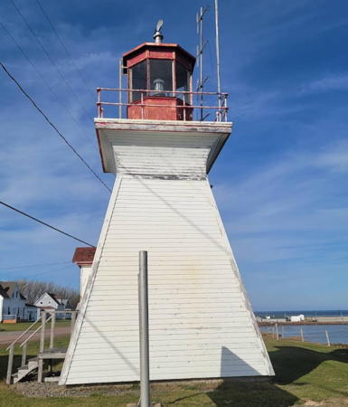
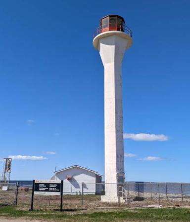
Richibucto Head Light, Cap Lumière, November 2022
Google Maps photo by Don Whittemore
Northumberland County (Miramichi Bay) Lighthouses
Miramichi Bay is a shallow, funnel-shaped estuary separated from the Gulf of St. Lawrence by barrier islands.

*
Lower Neguac Wharf Range Rear (2)
1892 (station established 1873). Inactive since 2003. 8 m (28 ft) square pyramidal wood tower with lantern and gallery, painted white with red trim and a red vertical stripe on the range line; lantern is red. Marinas.com has aerial photos and Google has a satellite view. The lighthouse was decommissioned at the end of the 2003 season. The front light, a small skeletal tower on the wharf, remained in service for several years, but it has been deactivated now as well. Located off NB 11 in Lower Neguac, near the northern entrance to Miramichi Bay. Site and tower closed (private property).Owner: Canadian Coast Guard (?). Site manager: private. ARLHS CAN-289; ex-Admiralty H1518.1.
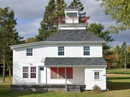
* Grand Dune Flats Range Front (relocated to Burnt Church)
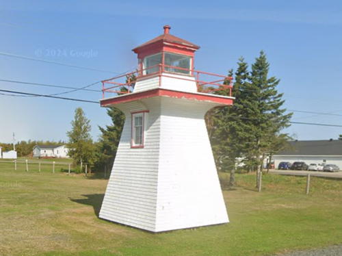
1916. Inactive since the 1950s. 12 m (39 ft) square wood lantern and gallery centered on the roof of a 2-story wood keeper's house. Kelly Anne Loughery contributed a 2009 photo snd Google has a 2024 street view (seen at right) and a satellite view. After deactivation the lighthouse was saved by Murray Anderson, who towed the lighthouse across the ice to its current location in Burnt Church, where it continues as a private residence. It has been altered by a modern addition. In the Lighthouse Digest issue for January 2003 Loughery reports how she and other members of the former New Brunswick Lighthouse Society rediscovered this forgotten lighthouse in August 2002; it is the only example of this design surviving in the province. Located on Bayview Drive a short distance east of Church River Road in Burnt Church. Site and tower closed (private property). Owner/site manager: private. ARLHS CAN-726.
Grand Dune Flats Range Rear (2?)
Date unknown (station established 1916). Active; focal plane 26.5 m (87 ft); continuous white light. 21 m (69 ft) triangular skeletal tower carrying a red daymark with a black vertical stripe. Trabas has a 2022 photo and Google has a satellite view. The range guides vessels in a channel dredged across the bay. The front light is on a similar tower 14 m (46 ft) tall. Located in a forest 1.2 km (3/4 mi) west of the front light, which is at the Grand Dune beach. Site status unknown. Owner: Canadian Coast Guard. Site manager: unknown. CCG A-1197; Admiralty H1472.1; NGA 7504.

Grand Dune Flats Range Front Light, Burnt Church, October 2024
Google Map street view
Grants Beach Range Rear (2) (relocated to Oak Point)
1903 (station established 1869). Inactive since 1972 at least. 12 m (37 ft) square pyramidal wood tower with lantern and gallery, painted white with red trim. Lighthouse Digest has Michel Forand's photo of the lighthouse, Google has a distant street view from NB highway 11, and Google has a satellite view. Around 2007 the lighthouse was sold and relocated 8 km (5 mi) to the east to Oak Point. The present owners repainted and refurbished their acquisition in 2009. Site and tower closed (private property). ARLHS CAN-728.
* Moody Point Range Rear
Date unknown. Active; focal plane 18.5 m (61 ft); yellow light, 2 s on, 2 s off. 14 m (46 ft) triangular skeletal tower carrying a trapezoidal daymark colored red with a black vertical stripe. Trabas has a 2022 photo and Google has a 2024 street view through a forest and a satellite view. This an inbound range for the Miramichi River. The front light is on a 9 m (30 ft) skeletal tower at the water's edge. Located beside Bartibog Church Road south of NB 11 on the east side of the Bartibog River. Site open, tower closed. CCG A-1198.9; Admiralty H1477.1; NGA 7512.
Grants Beach Range Rear (3?)
Date unknown. Active; focal plane 41 m (135 ft); red light, 2 s on, 2 s off. 24 m (79 ft) triangular skeletal tower carrying a trapezoidal daymark colored red with a black vertical stripe. Trabas has a photo and Google has a satellite view and a distant street view (along the line of the range) from NB highway 11, The modern front light is on a similar tower 13 m (43 ft) tall and 875 m (0.54 mi) to the east. Located on a hilltop north of highway 11 about 800 m (1/2 mi) east of Russellville Road. Site status unknown. Owner/site manager: Canadian Coast Guard. CCG A-1208; Admiralty H1491.1; NGA 7536.
Grants Beach Range Front (2) (relocated)
1903 (station established 1869). Inactive since 1972 at least. 12 m (37 ft) square pyramidal wood tower with lantern and gallery, painted white with red trim. Mark Hatcher has a 2015 photo (also seen at right), Marinas.com has aerial photos, and Google has a street view and a satellite view. In 1986 the lighthouse was sold and relocated a short distance to its present location. Located near #360 NB 11 at Lower Newcastle. Site and tower closed (private property); the lighthouse can be seen from a distance (more easily when there are no leaves on trees). Owner/site manager: private. ARLHS CAN-727.
Oak Point Range Front (2) (relocated to Miramichi)
1904 (station established 1869). Inactive since the mid 1960s. 10 m (33 ft) square pyramidal wood tower with lantern and gallery, attached to a modern dwelling. Lighthouse painted white with red trim. Originally located at Oak Point on the north shore of Miramichi Bay, this lighthouse has been relocated about 20 km (13 mi) southwest to Millbank, on the northeast side of Miramichi. The original lantern has been replaced by a square observation room. The dwelling was added in 2014. Mark Hatcher has a 2015 photo, Lighthouse Digest has a photo by Michel Forand, Wikimedia has a photo, Marinas.com has aerial photos, and Google has a street view and a satellite view. Trabas has Boucher's closeup photo of the modern Oak Point Front Light. Located on the north side of the Miramichi estuary about 2.5 km (1.5 mi) northeast of the Centennial Bridge. Site and tower closed (private property), but the lighthouse can be seen from NB 11. ARLHS CAN-732; ex-Admiralty H1479.

Grants Beach Range Front Light, Lower Newcastle, May 2015
Flickr Creative Commons photo by Mark Hatcher
* Oak Channel Range Rear
Date unknown. Active; focal plane 21 m (69 ft); yellow flash every 3 s. 17 m (56 ft) triangular skeletal tower carrying a trapezoidal daymark colored red with a black vertical stripe. Trabas has a 2022 photo and Google has a 2024 street view and a satellite view. This an inbound range for the Miramichi River. Trabas hsa a photo and Google has street view of the front light on a 6 m (20 ft) skeletal tower. Located on Schooner Road on the south side of the Miramichi estuary. Site open, tower closed. CCG A-1201; Admiralty H1478.1; NGA 7520.
#Portage Island Range Rear (3)
1986. Removed at least since 2019. This was a 20 m (66 ft) square skeleton tower with enclosed upper portion, carrying a daymark colored white with a red vertical stripe. Google has a satellite view of the former location. This was an approach range for Miramichi Bay. Located at the northern end of Fox Island, one of the barrier islands enclosing the bay. Accessible only by boat. Site status unknown. Owner/site manager: Canadian Coast Guard. ex-CCG A-1176.1; ex-Admiralty H1446.1; NGA 7484.
Grand Dune Outer Range Rear
Date unknown. Active; focal plane 32.5 m (107 ft); white light, 2 s on, 2 s off. 30 m (98 ft) triangular skeletal tower carrying a trapezoidal daymark colored red with a black vertical stripe. Trabas has a photo and Google has a satellite view. This is a range guiding vessels outbound across Miramachi Bay. The front light is on a caisson in the bay. Located near the center of Fox Island. Accessible only by boat. Site status unknown. Owner/site manager: Canadian Coast Guard. CCG A-1187.1; Admiralty H1452.1; NGA 7499.
* Point Escuminac (2)
1966 (station established 1841). Active; focal plane 20.5 m (68 ft); three white flashes every 20 s. 18 m (60 ft) "apple-core" hexagonal cylindrical concrete tower with flared top supporting the gallery and lantern. Tower is white, lantern and gallery red. Fog horn (two 3 s blasts every 60 s). 1-story fog signal building. Brenda Gelean's 2023 photo is at right, Trabas has a closeup 2022 photo, Philippe de Cockere has a 2018 photo, Marc Guitard has a 2008 photo, Steve P. Mackin has a 2021 closeup, Marinas.com has aerial photos, Guillaume Roy-Girard has a 2021 street view from the beach, and Bing has a satellite view. This is the oldest light station on the northern coast of the province, marking the entrances to Miramachi Bay to the north and Northumberland Strait to the south. The original lighthouse was an 18 m (59 ft) octagonal wood tower; it survived until it was demolished in 1966. Located beyond the end of NB 117 at the end of a dirt road; accessible by auto in good weather. Site open, tower closed. Owner/site manager: Canadian Coast Guard. . ARLHS CAN-389; CCG A-1163; Admiralty H1424; NGA 7580.

Point Escuminac Light, Escuminac, May 2023
Google Maps photo by Brenda Gelean

Kent County (Western Northumberland Strait) Lighthouses
Northumberland Strait is a narrow passage separating Prince Edward Island from the mainland provinces of New Brunswick and Nova Scotia. The strait is 15-30 km (9-19 mi) wide for much of its length. Since 1997 the Confederation Bridge has crossed the strait, linking Prince Edward Island and New Brunswick.

* Pointe Sapin Range Rear (2)
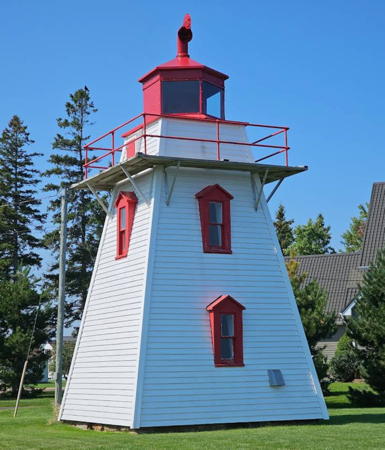
1910 (station established 1903). Inactive since 2016. 7.5 m (25 ft) square pyramidal wood tower with lantern and gallery, painted white with red trim and formerly a red vertical stripe on the range line. Wikimedia has David Broad's closeup photo, John MacKenzie has a 2022 closeup, Dennis Jarvis has a 2021 photo, Lighthouse Digest has a photo by Michel Forand, Marinas.com has aerial photos, and Google has a 2024 street view (seen at right) and a satellite view. The front light was on a short skeletal tower. The December 2016 edition of the Canadian light list deletes this range; it was replaced by a sector light (CCG A-1159.6; Admiralty H1418.2, NGA 7592) located across the street. Located beside NB 117 in Pointe Sapin. Site open, tower closed. Owner/site manager: Canadian Coast Guard. ARLHS CAN-401; ex-CCG A-1161; ex-Admiralty H1418.1; ex-NGA 7596.
* Richibucto Town Range Rear
Date unknown. Active; focal plane 23 m (75 ft); continuous yellow light. 19 m (62 ft) square cylindrical skeletal tower carrying a daymark colored white with a red vertical stripe. Trabas has a 2022 photo and Google has a street view and an indistinct satellite view. This range guides vessels in the Richibucto River approaching the town's waterfront. Trabas has a photo and Google has a street view of the front light, located beside Main Street on a 13 m (43 ft) skeletal tower. Located north of Légion Street in Richibucto. Site and tower closed (private property) but the tower can be seen from the street. Owner/site manager: Canadian Coast Guard. ARLHS CAN-1313; CCG A-1152; Admiralty H1402.1; NGA 7652.
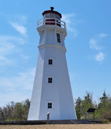
* Richibucto Head (Cap Lumière) (2)
Date unknown (station established 1865). Active; focal plane 18 m (59 ft); white flash every 5 s. 9 m (30 ft) square pyramidal wood tower with lantern and gallery, painted white with red trim; lantern is red. The keeper's house, formerly attached, was removed in the 1960s. Don Whittemore has the 2022 closeup at the top of this page, Wikimedia has François Maillet's photo, Lighthouse Digest has a photo by Michel Forand, C.W. Bash has a 2008 photo, Trabas also has Bash's photo, Marinas.com has aerial photos, and Google has a street view and a satellite view. Located on Cap Lumière Road off NB 505 in Cap Lumière. Site open, tower closed. Owner/site manager: Canadian Coast Guard. ARLHS CAN-430; CCG A-1128; Admiralty H1376; NGA 7660.

Pointe Sapin Range Rear Light, Pointe Sapin, October 2024
Google Maps street view
* Pointe à Jérôme Range Front (2)
About 1916 (station established 1883). Inactive since 2014. 4 m (14 ft) square pyramidal wood tower, painted white with a broad red vertical stripe on the range line. No lantern; the light was shown through a window at the top of the tower. Céline Go has a 2022 photo and Google has a street view and a satellite view. The lighthouse received Heritage designation in 2022. Located off NB 475 about 2.5 km (1.5 mi) north of Bouctouche. Site open, tower closed. Owner/site manager: Canadian Coast Guard. ARLHS CAN-729; ex-CCG A-1124; ex-Admiralty H1368; ex-NGA 7692.
#Pointe à Jérôme Range Rear (2)
About 1916 (station established 1883). Inactive since 2014 and removed in 2022. This was a 13 m (44 ft) square pyramidal wood tower with gallery, lantern and enclosed watch room, painted white with a broad red vertical stripe on the range line. The stripe was continued across a slatted white daymark covering the lower portion of the front of the tower. Mark Hatcher has a 2015 photo, Google has a distant 2013 street view. Google has a satellite view of the former location. The lighthouse, abandoned in the forest, appeared to be in poor condition, and the Coast Guard removed it by helicopter in 2022. Located off NB 475 about 2.5 km (1.5 mi) north of Bouctouche. Site and tower closed (private property) but the light is easily seen from the road. Owner: Canadian Coast Guard. Site manager: private. ARLHS CAN-730; ex-CCG A-1125; ex-Admiralty H1368.1; ex-NGA 7696.
Bouctouche Bar (Bouctouche Dune) (2)
2020 replica of 1902 lighthouse. Active; focal plane 11 m (36 ft); white flash every 4 s. 8 m (27 ft) square pyramidal tower, painted white with red trim. Tracy Miersch has a 2024 photo, Vince Allover has a closeup 2023 photo, Trabas has a 2022 photo, Marc-André Corriveau has a more distant view, Dennis Jarvis has a distant 2021 view, and Google has a satellite view. The Coast Guard demolished the 1902 lighthouse in December 2019 and replaced it in January 2020 with a copy prefabricated from composite materials. Anderson has a photo of a Coast Guard helicopter lowering the lower section of the new lighthouse. Marinas.com has aerial photos of the earlier lighthouse. Bouctouche Bar is a long barrier sand spit, now protected as a nature park, sheltering the bay of Bouctouche. Located at the end of the spit; accessible by boat or by a long hike, about 10 miles round trip. Owner: Canadian Coast Guard. Site manager: Irving Eco-Centre (Dune de Bouctouche) . ARLHS CAN-055; CCG A-1122; Admiralty H1362; NGA 7680.
* Dixon Point Range Rear (2) (relocated)
1919 (station established 1881). Inactive. Approx. 9 m (30 ft) square pyramidal wood tower with lantern and gallery, painted white with red trim; lantern is red. David Broad has a photo and Google has a street view and a satellite view. The abandoned lighthouse fell into poor condition and was deteriorating quickly by 2005, when the building was sold for $1 to André and Yvette Maille, the adjoining landowners. The Mailles relocated the tower onto their waterfront property and restored it in 2010. Dennis Jarvis has a closeup photo of the restored lighthouse. Located on NB 535 at Saint Thomas. Site open, tower closed. Owner/site manager: private. ARLHS CAN-161; ex-Admiralty H1369.1.
* Dixon Point (Range Front) (2)
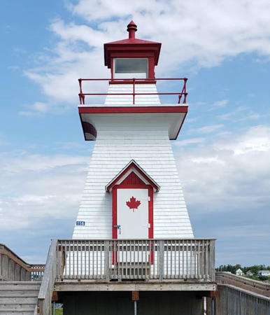
1919 (station established 1881). Inactive since 2014. 7.5 m (25 ft) square pyramidal wood tower with lantern and gallery, painted white with red trim; lantern is red. A 2023 photo is at right, Lighthouse Digest has a photo by John Jacquemain, and Google has a street view and a satellite view. After the range was discontinued the front light remained in service for many years.We need information on the current status of this lighthouse. Located on NB 535 at Saint Thomas, about 175 m (600 ft) southeast of the front light. Site open, tower closed. Owner/site manager: Canadian Coast Guard. ARLHS CAN-708; ex-CCG A-1120; ex-Admiralty H1369; ex-NGA 7686.

Dixon Point Light, St. Thomas, September 2023
Google Maps photo by Joseph S (Lestaticon)
* Cocagne Range Front (relocated)
1907. Inactive since 2018. 7.5 m (25 ft) square pyramidal wood tower with lantern and gallery, painted white with red trim and a broad vertical red stripe on the range line; lantern is red. This lighthouse was formerly located at the south end of the bridge over the Cocagne River on NB 134 in Cocagne. After being deactivated in 2018 it was relocated across the river entrance to the Cocagne Marina, where it was restored. Gilles Janvier's 2022 photo is at right, Lucia Cordeiro has a 2021 photo, and Google has a satellite view and a distant street view across the river. Trabas has Bash's photo of the lighthouse in service, Lighthouse Digest has a photo by Michel Forand, and Marinas.com has aerial photos.The rear light, originally on a pole, was recently on a 13 m (43 ft) skeletal tower. Located at the marina on the west side of the entrance to the Cocagne River. Site open, tower closed Owner/site manager: Cocagne Marina. ARLHS CAN-141; ex-CCG A-1116; ex-Admiralty H1354; ex-NGA 7708.
* Caissie Point (Cap des Caissie)
1872. Inactive since 2021. 12 m (39 ft) square pyramidal wood tower with lantern and gallery, painted white with red trim; lantern is red. Christopher Fraracci has a 2019 photo, Trabas has Bash's photo, Marinas.com has aerial photos, and Google has a street view and a satellite view. The lighthouse received Heritage designation in 2022. Located at the end of a side road off NB 530 north of Shediac. Site and tower closed (private property) but the light is easily seen from nearby. Owner: Canadian Coast Guard. Site manager: private. ARLHS CAN-743; ex-CCG A-1113; ex-Admiralty H1350; NGA 7724.
* Grande Digue
1912. Inactive since the 1950s. 6 m (20 ft) wood mast attached to the rear of 1-story shingle-covered wood equipment shelter. Google has a street view Google has a satellite view. This little light was built on the village wharf in Grande Digue. The light was lit and raised, like a flag on a flagpole, every evening. There were many similar lights in Canadian fishing villages, but this is the only known survivor. After deactivation it was moved to Hervé Richard, where it was used for storage of fishing gear. In 2006 it was recognized as a historic structure and donated to the Musée des Pionniers in Grande Digue. Located at the museum, on highway 530 in Grand Digue. Site open; museum and lighthouse open daily in July and August. Owner/site manager: Musée des Pionniers.

Cocagne Range Front Light, Cocagne, July 2022
ex-Google Maps photo by Gilles Janvier

Westmorland County (Shediac and Cape Tormentine Area) Lighthouses
* Shediac Wharf (Shediac Harbour) Range Rear (3?)
Date unknown (station established 1914). Inactive since 2017. 12.5 m (41 ft) square 2-story wood-building topped by an octagonal lantern room and gallery. Lighthouse painted white with red trim and a pyramidal red roof; there is also a red vertical stripe marking the range line. Linda Goodhue has a 2010 photo, Marinas.com has aerial photos (identified as Pointe du Chêne Light), and Google has a street view and a satellite view. The building includes public restrooms for the Pointe du Chêne Wharf, a popular attraction. The original range was discontinued in 1952. Anderson has a photo of a pyramidal wood tower believed to be the original rear range light. Located at the elbow of the wharf. Accessible by walking the pier. ARLHS CAN-940; ex-CCG A-1111; ex-Admiralty H1332.1; ex-NGA 7748.
* Pointe du Chêne Range Front (2)
1898 (station established 1895). Inactive since 2020. 7.5 m (25 ft) square pyramidal wood tower with lantern and gallery, painted white with red trim and a broad vertical red stripe on the range line; lantern is red. Hasnat Tareq has a photo, Negar Rahele Safe has a 2021 photo, Marinas.com has aerial photos, and Google has a street view and a satellite view. The lighthouse appeared abandoned in Mark Hatcher's 2015 photo. Anderson writes, "In 2017, both the front and rear Pointe du Chêne Range Lights appeared to be undergoing restoration and were missing their lantern rooms." The lighthouses were restored later in 2017. A closeup photo of the freshly restored tower is available. The history of these range lights is obscure; they may have been rebuilt in 1960. The lighthouse was relocated farther from the beach in 1990. Located in front of the restaurant in Parlee Beach Provincial Park, off exit 37 of NB 15 east of Shediac. Site open, tower closed. Owner: Canadian Coast Guard. Site manager: Parlee Beach Provincial Park. ARLHS CAN-397; ex-CCG A-1107; ex-Admiralty H1328; ex-NGA 7736.
* Pointe du Chêne Range Rear (2)
1898 (station established 1895). Inactive since 2020. 12 m (39 ft) square pyramidal wood tower with lantern and gallery, raised on pilings, painted white with red trim and a broad vertical red stripe on the range line; lantern is red. Mark Hatcher has a 2015 photo, Jordan Gillespie has a 2023 closeup, Audrey Boulanger has a photo, Marinas.com has aerial photos, Huelse has a historic postcard view, and Google has a 2012 street view and an indistinct satellite view. Anderson writes, "In 2017, both the front and rear Pointe du Chêne Range Lights appeared to be undergoing restoration and were missing their lantern rooms." The lighthouses were restored later in 2017. Located in Parlee Beach Provincial Park, off exit 37 of NB 15 east of Shediac. Site open, tower closed. Owner: Canadian Coast Guard. Site manager: Parlee Beach Provincial Park. ARLHS CAN-713; ex-CCG A-1108; ex-Admiralty H1328.1; ex-NGA 7740.
** Cape Jourimain
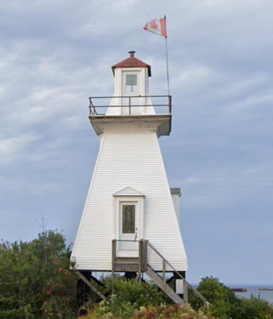
1870. Inactive since 1997. 16 m (53 ft) octagonal wood tower with lantern and gallery, painted white; lantern is red. Bruno Tosato's 2023 photo is at right, Bry Simms has a 2021 photo, Marinas.com has aerial photos, and Google has a 2019 photo and a satellite view. This historic lighthouse was deactivated in 1997 when the Confederation Bridge was completed to link New Brunswick to Prince Edward Island. After being abandoned by the Coast Guard the lighthouse began to deteriorate. The nearby Cape Jourimain Nature Centre launched a drive for funds needed to repair and repaint the tower and began negotiating with Fisheries and Oceans to obtain ownership. The transfer of ownership finally took place in 2015, after the lighthouse was recognized as a Heritage Lighthouse. The lighthouse was threatened by erosion, so in August 2016 Mervil Rushton Building Movers relocated the tower 60 m (200 ft) back from the cliff. The lighthouse was restored in 2017-18 and in July 2019 it opened to the public for the first time. The Centre also has historical exhibits and visitor facilities. Located at the last exit in New Brunswick before the bridge. Accessible by a 1.8 km (1.1 mi) trail (entry fee); in season a jitney provides transportation from the museum to the lighthouse. Site open, tower open on Saturdays in July and August. Owner: Canadian Coast Guard. Owner/site manager: Cape Jourimain Nature Centre (Cape Jourimain Lighthouse). . ARLHS CAN-706; ex-Admiralty H1318.

Cape Jourimain Light, May 2023
Google Maps photo by Brunno Tosato
* Cape Tormentine Outer Wharf (Range Front) (3)
1940s (station established 1901). Inactive 1997-98 and since 2022; still listed with focal plane 12 m (39 ft); red light, 1 s on, 1 s off. 11 m (33 ft) square tower with lantern and gallery and with an unusual and attractive pepperpot shape, cylindrical at the base and strongly tapered above. Lighthouse originally painted white with red trim. but no paint remains. Dennis Jarvis has a 2010 photo, Lighthouse Digest has Dana Rushton's photo, Alan Culley has a 2007 photo, Trabas has Boucher's photo, Shane MacClure has 1997 photo, Wikipedia has a winter photo by Gordon Robertson, and Google has a satellite view. In poor shape recently the lighthouse was heavily damaged by Hurrican Fiona in late September 2022 and is now out of service and gravely endangered: Dominique Boisseau's 2024 photo shows the lighthouse severely deteriorated. The range was discontinued when the Confederation Bridge was opened in 1997, but the front light was reactivated the following year at the request of local fishermen. In 2004 a peatmoss company leased the wharf and fenced it so that there was no longer public access to the lighthouse; it's reported that access has been restored more recently. The Cape Tormentine Community Development Corporation is seeking ownership of the lighthouse. Located at the end of the former Cape Tormentine ferry wharf, which was made obsolete by the bridge. Accessible by walking the pier. Site open, tower closed. Owner: Canadian Coast Guard. Site manager: unknown. . ARLHS CAN-112; CCG A-1090; Admiralty H1308; NGA 7824.
* Cape Tormentine Outer Wharf Range Rear (Ferry Road) (2)
1907 (station established 1901). Inactive since 1997. 12.5 m (40 ft) square pyramidal wood tower with lantern and gallery, raised on pilings, painted white with red trim and a broad vertical red stripe on the range line; lantern is red. Sibling of Pointe du Chêne Range Rear. Annik Paquette has a 2021 photo, a 2008 photo is available, Marinas.com has aerial photos, and Google has the 2024 street view seen at right and a satellite view. Abandoned with the end of the ferry service in 1997, this lighthouse deteriorated rapidly, to the point where the lantern collapsed. In 2016 ownership of the lighthouse was transferred to the Cape Tormentine Community Development Corporation. Restoration began in 2017 and continued in 2018. Located on Old Ferry Road near the base of the former ferry pier. Site open, tower closed. Owner/site manager: Cape Tormentine Community Development Corporation. ARLHS CAN-112; ex-Admiralty H1308.1.
#Indian Point (Cape Tormentine Entrance) Range Front
1955. Inactive since 1998 and destroyed in 2022. 6 m (20 ft) square pyramidal wood tower, painted white with a broad vertical red stripe on the range line. No lantern; the light was shown through a square window. Lighthouse Digest has Dana Rushton's photo, Marinas.com has aerial photos, and Bing has a satellite view of its former location. In June 2022 the lighthouse was to be moved to the entrance to the Cape Tormentine Campground; it was actually loaded on a trailer for the move when it caught fire and was burned beyond repair. A new foundation had been prepared for it, so a replica is was to be built at that location. Work on the replica began in September 2022. Google has a 2024 street view and a satellite view of the replica, but it does not much resemble the original. Formerly located at the end of a dirt road off NB 960 about a mile south of Cape Tormentine. ARLHS CAN-249; ex-Admiralty H1306.
#Indian Point (Cape Tormentine Entrance) Range Rear
1955. Inactive since 1998 and disappeared by 2022. 12 m (38 ft) square pyramidal wood tower with lantern and gallery, painted white with red trim and a broad vertical red stripe on the range line. Lighthouse Digest has Dana Rushton's photo, Marinas.com has aerial photos, Huelse has a historic photo, and Google has a distant 2013 street view. Abandoned and in very poor condition, this lighthouse somehow disappeared over the winter of 2021-22. Google has a satellite view of its former location. Formerly located off NB 960 near Vista Drive about a mile south of Cape Tormentine. Site open, tower closed. Owner: Canadian Coast Guard. Site manager: private. ARLHS CAN-250; ex-Admiralty H1306.1.

Cape Tormentine Outer Wharf Range Rear Light, September 2024
Google Maps street view
#[Fort Monckton (Fort Monckton Point, Gaspareaux Point, Old Fort Point) (2?)]
1972 (station established 1908). Inactive since 2014 and demolished in 2016. This was a 7 m (23 ft) round cylindrical tower, painted red with one white horizontal band, mounted on a square concrete platform supported by concrete piles. ARLHS has Steve Prosser's 2012 photo, Wikimedia has a 2006 photo, and Google has a 2013 street view, but the light is no longer seen in Google's satellite view. Huelse has a historic postcard view of the original lighthouse, a square wood tower that stood on the same platform. The light was built on the site of Fort Gaspareaux, built by the French in 1751; it was renamed Fort Monckton after being captured by British forces in 1755. The original lighthouse burned sometime in the late 1950s and there was no light until 1972. The 1972 light was deactivated in December 2014 and demolished in January 2016. Located on a low headland at the head of Baie Verte, an inlet of Northumberland Strait, near the village of Port Elgin. Site open, tower closed. Owner: Canadian Coast Guard. Site manager: Parks Canada (Fort Gaspareaux National Historic Site). ARLHS CAN-183; ex-CCG A-1086; ex-Admiralty H1304; ex-NGA 7844.

Information available on lost lighthouses:

Notable faux lighthouses:

Adjoining pages: North: New Brunswick North Coast | Northeast: Western Prince Edward Island | East: Northwestern Nova Scotia | South: Southern New Brunswick

Return to the Lighthouse Directory index | Ratings key

Posted September 8, 2003; checked and revised April 1, 2025. Lighthouses: 31. Site copyright 2025 Russ Rowlett and the University of North Carolina at Chapel Hill.