The Republic of Nicaragua is a country of Central America located south of Honduras and north of Costa Rica. Spanning the isthmus, Nicaragua has coasts facing southwest on the Pacific Ocean and east on the Caribbean Sea. This page describes the lighthouses of the Caribbean coast; there is a separate page for the Pacific coast.
The east coast of Nicaragua is low and sparsely populated. Known historically as the Mosquito or Miskito Coast, it was a British colony for much of the 18th century. Britain did not transfer sovereignty officially to Nicaragua until 1860. In the Bluefields area English is still spoken along with Spanish and the indigenous Miskito language.
Nicaragua is divided into 15 departments (departamentos) and two self-governing autonomous communities; all but the southernmost section of the Caribbean coast lies within the autonomous communities.
In Spanish the word for a lighthouse is faro, baliza is a beacon, isla is an island, cabo is a cape, punta is a promontory or point of land, péñon is a rock, arrecife is a reef, bahía is a bay, ría is an estuary or inlet, estrecho is a strait, río is a river, and puerto is a port or harbor.
Aids to navigation in Nicaragua are managed by the Aquatic Transport Directorate of the Ministry of Transportation and Infrastructure.
ARLHS numbers are from the ARLHS World List of Lights. Admiralty numbers are from volume J of the Admiralty List of Lights & Fog Signals. NGA numbers are from NGA Publication 110.
- General Sources
- World of Lighthouses - Nicaragua
- Photos by various photographers available from Lightphotos.net.
- Online List of Lights - Nicaragua
- Photos by various photographers posted by Alexander Trabas.
- World Lights - Other Regions of the World
- Historic postcard views posted by Michel Forand.
- Google Maps
- Satellite view of Caribbean Nicaragua.
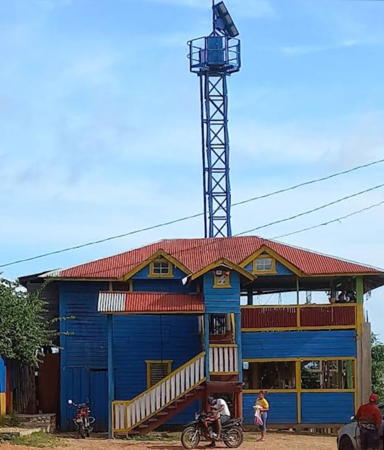
Bragmans Bluff Light, November 2023
Google Maps photo by Roland Angerer