Lighthouses of Norway: Oslo

The Kingdom of Norway (Norge in Norwegian) is one of the world's most maritime nations. The country is long and narrow with drowned valleys called fjords that bring the sea far inland in most regions. The mainland coast is estimated to be 2650 km (1650 mi) long and when all the islands and minor indentations are counted the total coastline approaches an astonishing 60,000 km (37,500 mi), long enough the go around the world one and a half times. With such a lengthy and rocky shore it's not surprising that Norway has a large number of lighthouses.

Norway is divided into 15 counties (fylker) and the counties are divided into townships (kommuner). This page lists lighthouses of the national capital, the City and County of Oslo. Located at the head of the Oslofjord, this is Norway's largest city, with a population of about 750,000, and a major port.

Although it has always been considered a separate realm, Norway has only been independent since 1905; it was ruled by the Danish king until 1814 and then by the Swedish king until the Norwegian parliament arranged a peaceful separation of the two kingdoms.

In Norwegian a lighthouse is a fyrtårn (fire tower) or simply a fyr; a fyrlykt is a beacon and a lyktehus is a lantern. Øy is an island, holmen is an islet, skjær is a skerry (a tiny island or rocky reef), sund is a strait (often between an island and the mainland), bukt is a bay, nes is a headland, and havn is a harbor.

Aids to navigation in Norway are maintained by the Kystverket (Coast Directorate), an agency of the Ministry of Transport and Communications.

ARLHS numbers are from the ARLHS World List of Lights. NF numbers are from the Norsk Fyrliste, the official Norwegian light list. Admiralty numbers are from volume B of the Admiralty List of Lights & Fog Signals. U.S. NGA List numbers are from Publication 115.

General Sources
Online List of Lights - Norway - Skaggerak
Photos by various photographers posted by Alexander Trabas; many of these photos were taken by Michael Boucher, Rainer Arndt, Ronald Wöhrn, or Capt. Peter Mosselberger.
Norwegian Lighthouse Association
News and photos from the Association.
Leuchttuerme.net - Oslo Fjord
Photos posted by Malte Werning.
Lighthouse Pages from Anke and Jens - Norway
Good photos and and brief accounts for some of the Oslofjord lighthouses, in English.
World Lighthouses - Norway
Photos taken in 2008 by James Christie.
Norway Lighthouses
Photos by Larry Myhre, also in 2008.
Leuchttürme in Norwegen
Photos by Andreas Köhler.
Lighthouses in Norway
Photos by various photographers available from Wikimedia.
World of Lighthouses - Norway
Photos by various photographers available from Lightphotos.net.
Norwegische Leuchttürme
Photos by Klaus Huelse.
Norsk Fyrliste
Current edition of the Norwegian light list.
Norwegische Leuchttürme auf historischen Postkarten
Historic postcard images, also posted by Klaus Huelse.
Liste over Norske Fyr
From Norwegian Wikipedia, a handy list of Norwegian light stations with their dates of establishment.
GPSNauticalCharts
Navigational chart for Oslo harbor.
Google Maps
Satellite view of Oslo.


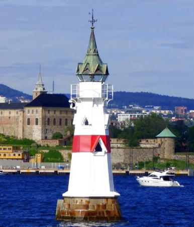
Kavringen Light, Oslo, June 2021
Google Maps photo by Gopi Nathan

Oslo's harbor contains a group of about a dozen islands of varying sizes. The main channel for large vessels paases around the north side of the islands. There is also an approach around the south side of the islands and a central approach that passes through the island group, north of Heggholmen and south of Lingøy.

Central Approach Lighthouses (listed inbound)
#Rambergskårflu
Date unknown. Replaced. This was a 7.5 m (25 ft) lantern, painted white with a red roof, mounted on a round stone pier. It has been replaced by a light on a mast (focal plane 7 m (23 ft); red flash every 3 s); Trabas has Arndt's 2018 photo and Google has a satellite view. Located southwest of Heggholmen, one of several islands off the Oslo waterfront. Accessible only by boat. Site open, tower closed. Active light: NF-022600; Admiralty B2407; NGA 0474.
Rausekkene (2)
Date unknown. Active; focal plane 8.5 m (28 ft); white light, 3 s on, 3 s off. 8.5 m (28 ft) hexagonal fiberglass tower mounted on a concrete pile. Lighthouse colored white with two narrow black horizontal bands and a red top. Trabas has a 2023 photo and Bing has a satellite view. NGA describes an earlier light, a short post. Located on the north side of the channel off the southern tip of Nokkholmen. Accessible only by boat. Site open, tower closed. Active light: NF-022900; Admiralty B2408; NGA 0484.
Stangskjærrabben (3)
Date unknown (station established 1892). Active; focal plane 7 m (23 ft); red light occulting three times every 10 s. 7 m (23 ft) hexagonal fiberglass tower mounted on a concrete pile. Lighthouse colored white with two narrow black horizontal bands and a red top. Trabas has Arndt's closeup 2018 photo and Google has a satellite view. This light replaced a hexagonal stone tower with lantern and gallery; a closeup and a distant view are available. Located on the south side of the channel about 600 m (3/8 mi) west of the Heggholmen lighthouse (next entry). Accessible only by boat. Site open, tower closed. NF-023000; Admiralty B2410; NGA 0480.
* Heggholmen (Gressholmen)
1826 (house built in the late 1700s). Active; focal plane 6 m (20 ft); green light, 1 s on, 1 s off. 15 m (49 ft) 1-1/2 story "Swiss-chalet" wood keeper's house topped by a belfry-like fog bell tower; bell removed. The 6th order Fresnel lens is mounted in a small lantern on a ledge low on a front corner of the building. Lighthouse painted white. A 2023 photo is at right, another 2023 photo is available,Trabas has Boucher's 2011 photo, Huelse has a good photo, a photo from the east shows the original Stangskjærrabben light in the background, Yveline Kadiski has a street view, and Google has a satellite view. The steeple was removed temporarily in 2022 while the building was repaired and repainted. This remarkable old lighthouse is preserved as a historic monument; the interior is restored to its appearance in the 1920s. The port authority uses the building as a meeting site. It was the first Norwegian lighthouse to be connected to electric power (1928). Six generations of the Iversen family supplied keepers for this lighthouse for 126 years. Located on a short jetty on the north point of Heggholmen, an island in the inner Oslofjord, marking a secondary channel approaching the city. There is a village on the island, and ferry transportation from the city is available. Site open, tower closed. Operator: Oslo Havn (port authority). . ARLHS NOR-112; NF-023100; Admiralty B2412; NGA 0488.
#Daggerskjærgrunnen (1)
Date unknown. Replaced. This was a 6 m (20 ft) lantern mounted on a round stone pier. The light has been replaced by a light on a mast (focal plane 8 m (26 ft); green light, 2 s on, 2 s off); Trabas has Köhler's 2019 photo and Google has a satellite view. Located of the western tip of Bleikøy. Accessible only by boat. Site open, tower closed. ARLHS NOR-378. Active light: NF-023303; Admiralty B2415; NGA 0493.
Blindskjærbåen (Blindeskjær) (2)
Date unknown. Active; focal plane 8 m (26 ft); red light, 1 s on, 1 s off. 12 m (39 ft) mast mounted on a platform supported by a round white tower. Eli Svardal has a 2025 photo, Trabas has a 2023 photo and and Google has a fuzzy satellite view. This light replaced a 5 m (16 ft) lantern and gallery mounted on four straight piles. Located on a rock off the southeast side of Bleikøy, a forested island only a few hundred meters off the waterfront of downtown Oslo. Accessible only by boat. Site open, tower closed. ARLHS NOR-377; NF-023802; Admiralty B2417.1; NGA 0502.

Heggholmen Light, Oslo, August 2023
Google Maps photo by Fahad M
Bleikøy (2)
Date unknown. Active; focal plane 9 m (30 ft); white, red or green light depending on direction; occulting once every 4 s. 8 m (26 ft) hexagonal fiberglass tower. Lighthouse colored white with two narrow black horizontal bands and a red top. Lantern painted white with a red roof. Trabas has a 2023 photo and Google has a satellite view. The original light was a 4 m (13 ft) lantern mounted on a stone base; a distant photo is available. Located at the northeastern point of the island, which is accessible by ferry. Site status unknown. ARLHS NOR-376; NF-023400; Admiralty B2416; NGA 0504.
#Sandtangen (1)
Date unknown. Replaced. This was a 7.5 m (25 ft) lantern mounted on a square concrete pier. The light has been replaced by a light on a mast (focal plane 8 m (26 ft); red flash every 2 s). Trabas has a 2023 photo and Bing has a satellite view. Located of the eastern tip of Hovedøya, an island just off the Oslo waterfront. Accessible only by boat. Site open, tower closed. Active light: NF-024106; Admiralty B2418; NGA 0508.

Main Approach Lighthouses (listed outbound)
* Aker Brygge
Date unknown. Active (privately maintained); focal plane about 12 m (39 ft); red light, pattern unknown. 8 m (26 ft) round tower with lantern and gallery painted with black and white horizontal bands. Oksana Repik's 2023 photo is at right, Köhler has a closeup 2019 photo is at right, a 2022 photo is available, Michael Grande has a closeup photo of the light in action, and Google has a 2024 street view and a satellite view. Located on the Aker Dock (brygge) in downtown Oslo. Site open, tower closed. Not listed by the Norsk Fyrliste or by the Admiralty.
#Kavringsanden (1)
Date unknown. Replaced. This was a 6.5 m (21 ft) lantern mounted on a round concrete pier. The light was replaced by a light on a mast (focal plane 12 m (39 ft); green light, 1 s on, 1 s off); Trabas has Arndt's 2018 photo and Google has a satellite view. Located just off the Oslo waterfront, north of the Kavringen lighthouse. Accessible only by boat. Site open, tower closed. NF-024849; Admiralty B2429.
#Nordre Kavringdynga (1)
Date unknown. Replaced. This was a 6 m (20 ft) lantern mounted on a round concrete pier. The light was replaced by a light on a mast (focal plane 11.5 m (38 ft); quick-flashing white light); Trabas has Erich Hartmann's 2025 photo and Google has a satellite view. Located about 200 m (650 ft) southeast of the Kavringsanden light and 300 m (1000 ft) northeast of the Kavringen lighthouse. Accessible only by boat. Site open, tower closed. NF-024910; Admiralty B2428.2; NGA 0522.

Aker Brygge Light, Oslo, June 2023
Google Maps photo by Oksana Repik
Kavringen
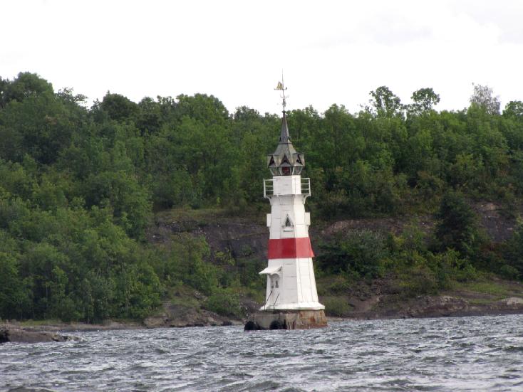
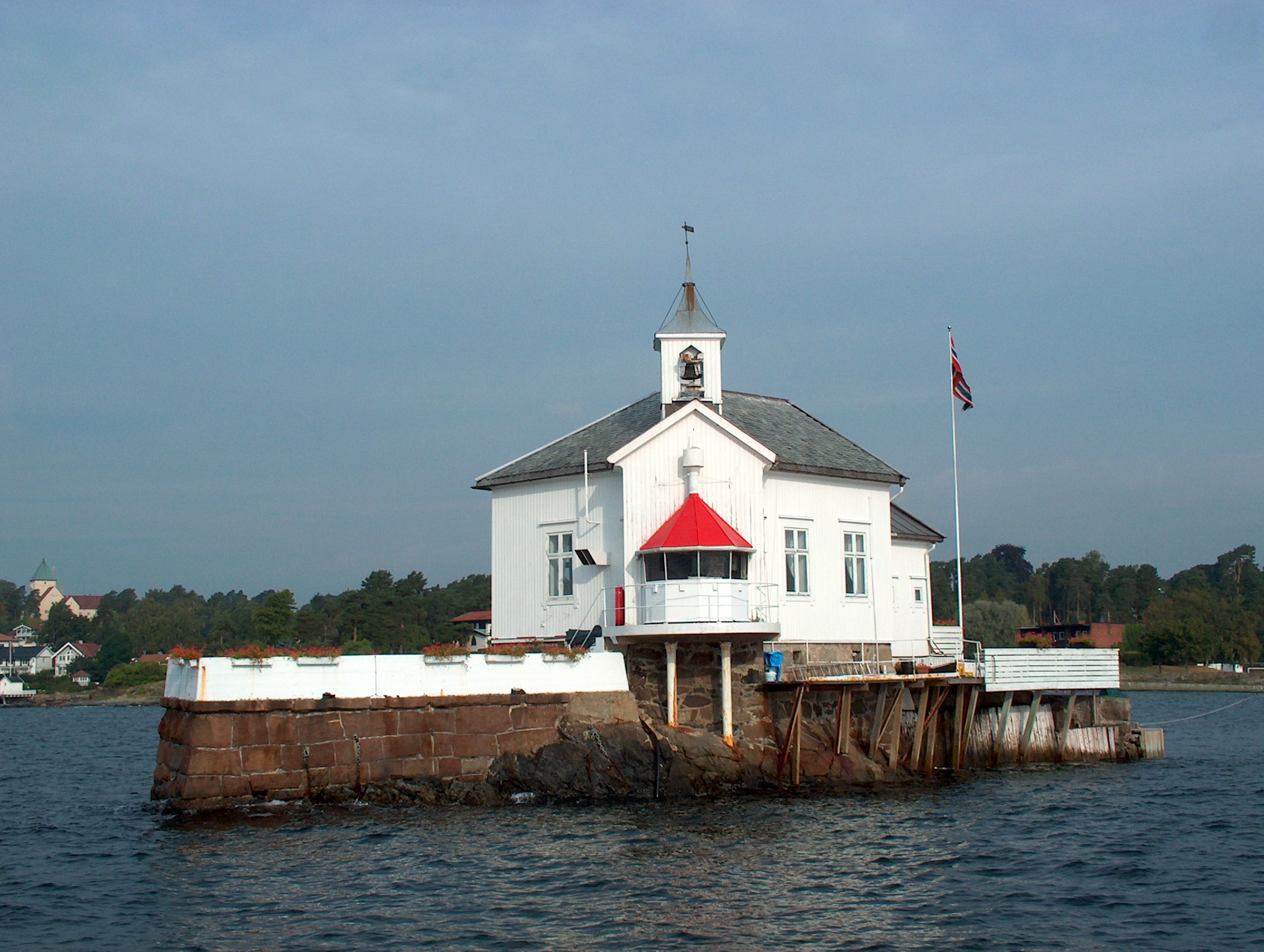
1892. Active; Two directional lights, one shining northeast at focal plane 12 m (39 ft); white, red or green light, depending on direction, occulting once every 6 s, and the other shining southwest at focal plane 28 m (92 ft) (?); white, red or green light, depending on direction, occulting once every 6 s. 20 m (66 ft) octagonal wood tower with an unusual wood lantern topped by a spire. Tower painted white with one narrow red horizontal band; lantern is brown. Gopi Nathan's 2021 photo is at the top of this page, Trabas has Erich Hartmann's 2025 photo, Erik Blom Erlandsen has a 2022 photo, Anke and Jens have a page for the lighthouse, Werning has a photo, Huelse has a photo, and Google has a satellite view. This lighthouse was built after the steamship Norway wrecked on the Kavringen reef in 1890. The lighthouse guides boith inbound and outbound ships. In 2006 the lighthouse was carefully restored; one of the photos on the Anke/Jens page shows this work in progress. Located in the inner harbor of Oslo, between Hovedøya and the Filipstad container terminal. Accessible only by boat. Site and tower closed. . ARLHS NOR-069; NF-024800; Admiralty B2428; NGA 0524.
* Bygdøynes
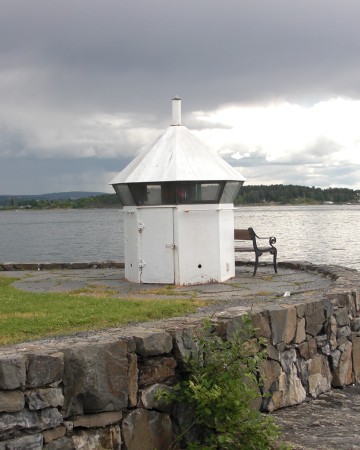
Date unknown. Active? 4 m (13 ft) octagonal cast iron lantern, painted white. has a closeup 2025 photo, Andreas Köhler contributed a 2009 photo, Mike Parsons has a 2015 street view, and Google has a satellite view. Located at the eastern tip of the Bygdøy peninsula near the Norwegian Maritime Museum. Site open, tower closed. Site manager: Norsk Maritimt Museum.
Dyna
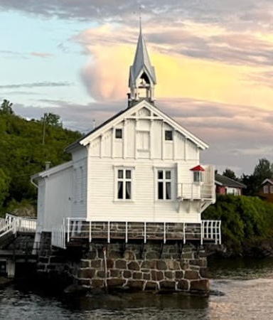
1875. Active; focal plane 6 m (20 ft); white, red or green light depending on direction, occulting twice every 8 s. 12.5 m (41 ft) wood keeper's house with a lantern in one corner and a fog bell in a steeple overhead. Lighthouse painted white, lantern roof red. Trabas has Erich Hartmann's 2025 photo, Marcel Masanz's 2023 photo is at right, Wikimedia has Erlend Bjørtvedt's photo, Anke and Jens have a page for the lighthouse, Tim Ove has a nice photo, the Lighthouse Stamp Society has a wonderful closeup, Werning also has a photo, and Google has a satellite view. Surrounded by a stone wall with an icebreaking prow, this remarkable little lighthouse looks like a ship sailing down the Oslofjord. The keeper was also responsible for nearby lighthouses, including Koppernaglen and Kavringen. In 1992 the light station was renovated as a private banqueting facility, available for parties of 20-40 persons. Located on a rock about 200 m (220 yd) off the coast of Bygdøy about 3 km (2 mi) west of downtown Oslo. Accessible only by boat. Site open to guests with banquet reservations. Site manager: Dyna Fyr . ARLHS NOR-308; NF-024200; Admiralty B2422; NGA 0512.
#Koppernaglen (1)
Date unknown (station established 1898). Replaced. This was a 7 m (23 ft) lantern and gallery mounted on a concrete pier. Werning has a good photo, Pepe Vilero has a 2011 photo, Huelse has a photo, another photo shows the location of this light directly across the channel from the Dyna lighthouse, and Google has a satellite view. The light was replaced by a light on a mast (focal plane 8 m (26 ft); green light, 2 s on, 2 s off). Trabas has a 2025 closeup. Accessible only by boat. Site and tower closed. ARLHS NOR-382. Active light: NF-024241; Admiralty B2424; NGA 0516.

Dyna Light, Oslo, May 2023
Google Maps photo by Marcel Masanz
#Nakkholmsteinen (1)
Date unknown. Replaced. This was a 6 m (20 ft) lantern mounted on a round stone pier. The light has been replaced by a light on a mast (focal plane 14 m (46 ft); green light, 1 s on, 1 s off); Trabas has Erich Hartmann's 2025 photo and Google has a satellite view. Located on a shoal about 400 m (1/4 mi) west of the island of Nakkholmen. Accessible only by boat. Site open, tower closed. ex-NF-022800. Active light: NF-024239; Admiralty B2416.5; NGA 0475.1.

Information available on lost lighthouses:

Notable faux lighthouses:

Adjoining page: North: Lake Mjøsa | South and West: Akershus

Return to the Lighthouse Directory index | Ratings key

Posted April 10, 2006. Checked and revised July 20, 2026. Lighthouses: 16. Site copyright 2026 Russ Rowlett and the University of North Carolina at Chapel Hill.