Lighthouses of the Philippines: Southwest Luzon

The Republic of the Philippines (Republika ng Pilipinas in Filipino) includes more than 7600 islands stretching over 1750 km (1100 mi) of the western Pacific and separating the Philippine Sea on the east from the South China Sea on the west. The largest islands are Luzon at the northern end of the country and Mindanao at the southern end. As of 2024 the population of the country was about 114 million.

The archipelago was a Spanish colony until the Spanish-American War of 1898 brought the islands under U.S. administration. Japan occupied the islands during World War II (1942-45) and the country became independent shortly thereafter (1946).

The country is divided into 17 regions and subdivided into 81 provinces. Luzon, site of the capital city of Manila, dominates the northern half of the Philippines and includes seven of the regions. This page describes lighthouses of the southwestern side of the island, including the greater Manila area and the southwestern coasts of the Calabarzon and Central Luzon Regions.

Filipino and English are official languages in the Philippines. In Filipino a lighthouse is called a parola; an island is an isla or pulo. Many English maritime terms have been adopted into Filipino, including cape, bay, and port, and the names of historic lighthouses are often retained in their Spanish forms.

Lighthouses in the Philippines are maintained by the Marine Safety Services Command of the Philippine Coast Guard (PCG). Notices to Mariners are posted by the National Mapping and Resource Information Agency (NAMRIA).

ARLHS numbers are from the ARLHS World List of Lights. PCG numbers are the Philippines Light List numbers, where known. Admiralty numbers are from volume F of the Admiralty List of Lights & Fog Signals. U.S. NGA List numbers are from Publication 112.

General Sources
Lighthouses in the Philippines
Photos and observations in blog entries by Loyd Martinez.
Lighthouses in the Philippines
Wikipedia article, with links to articles on several of the individual lighthouses.
Spanish Lighthouses of the Philippines
The Directory's own list of the Spanish light stations, with notes on their current status.
Lighthouses in the Philippines
Photos by various photographers available from Wikimedia.
World of Lighthouses - Philippines
Photos by various photographers available from Lightphotos.net.
Online List of Lights - Philippines
Photos by various photographers posted by Alexander Trabas. Photos for Luzon are by Rainer Arndt.
NAMRIA- Notices to Mariners
Monthly notices archived since 2013.
Leuchttürme Asiens auf historischen Postkarten
Historic postcard images posted by Klaus Huelse.
GPSNavigationCharts
Navigational chart information for the Philippines.
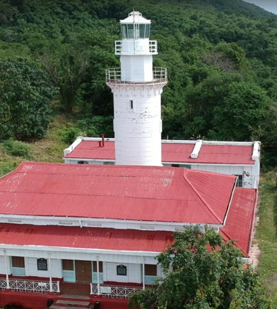

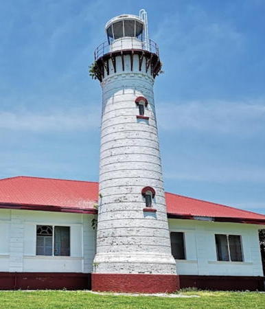
Malabrigo Point Light, Batangas Province, January 2018
Google Maps drone view by T. Pedrosa

Calabarzon Region Southwest Coast Lighthouses

Quezon Province: South Coast Lighthouses
Quezon Province spans the narrow waist of the southeastern peninsula of Luzon. Lighthouses on the northern coast are listed on the Northeast Luzon and Batanes page.

 
Sibalun (Sibalon) Island (Guinayangan (2))
Rebuilt in 2021. Active; focal plane about 12 m (39 ft); white flash every 3 s. Approx. 10 m (33 ft) white concrete pillar rising from a pyramidal base and centered on an octagonal pier. Geia Lopez has a closeup photo, another photo is available, and Google has a satellite view. NGA lists a fiberglass tower for this light. Located on a sandy reef at the head of the Ragay Gulf about 6 km (4 mi) east of Guinayangan. Accessible only by boat. Site open, tower closed. PCG-0088; Admiralty F2505.25 (ex-F2505.3); NGA 14135.3.
Bondoc Point
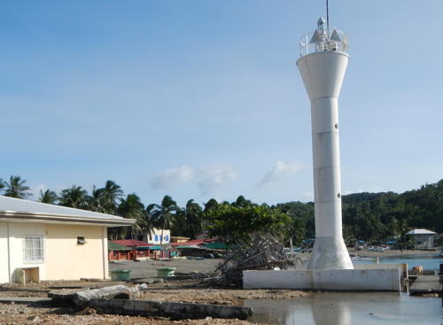
Date unknown. Active; focal plane at least 60 m (197 ft); two white flashes every 15 s. Approx. 15 m (49 ft) round barbell-shaped white fiberglass tower. VisitQuezon has a closeup photo on its Facebook page, Jeriel Arendain has a photo, Patrick Gavino has a view from the sea, Richard Maglinte also has a view from the sea, and Google has a satellite view. Located at the tip of the Bondoc Peninsula, which borders the west side of the Ragay Gulf. Site status unknown. Admiralty F2503.7; NGA 14135.5.
* San Francisco
Date unknown. Active; focal plane unknown; white flash every 5 s. Approx. 9 m (30 ft) white tower. No photo available and the light has not been found in Google's satellite view. San Francisco is a fishing port on the west side of Bondoc Peninsula. The listed location is at the south end of the San Francisco waterfront. Site status unknown. PCG-0595; Admiralty F2503.75.
* Catanauan
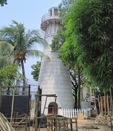
Date unknown. Active; focal plane 11 m (36 ft); red flash every 5 s. 10 m (33 ft) square concrete pillar with a buttressed base, painted white. Google has a 2019 street view (a 2016 version is seen at right) and a satellite view. Located at the foot of Nabatasan Street on the waterfront of Catanauan, a fishing port facing the Sibuyan Sea. Site open, tower closed. PCG-0080; Admiralty F2594; NGA 14208.

Catanauan Light, Catanauan, June 2016
Google Maps street view
* General Luna (2)
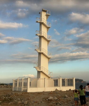
Date unknown. Active; focal plane 15 m (49 ft); white flash every 5 s. Approx.10 m (33 ft) round white concrete post with a stairway that spirals around the tower. Elmer Revuelta has a closeup 2021 photo and the tower is centered in an indistinct Google satellite view. This light apparently replaced a triangular skeletal tower seen in Monds Alsado's 2010 photo and Cesar C. Cambay's distant 2014 photo. Located on the waterfront at General Luna. Site open, tower closed. PCG-0079; Admiralty F2596; NGA 14210.
* Macalelon River
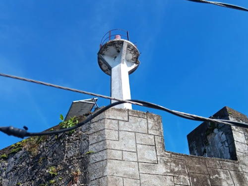
Date unknown. Active; focal plane 15 m (49 ft); two red flashes every 5 s. 9 m (30 ft) square concrete pillar with a buttressed base mounted on a sqaure stone tower (perhaps the stump of a historic watchtower). A 2024 photo by Fredie Chavez is at right, Giày Hiệp Thư has a photo, and Google has an indistinct satellite view. Located at the foot of the waterfront street of Macalelon. Site open, tower closed. PCG-0078; Admiralty F2598; NGA 14212.
* Pitogo (2?)
Date unknown (station established 1903). Active; focal plane 24 m (79 ft); red flash every 5 s. 10.5 m (34 ft) slender white concrete tower with a buttressed or pyramidal base. Photos (halfway down the page) and a closeup (also halfway down the page) are available but the light is hard to find in Google's satellite view. Located near the historic Saint Paul's Church in downtown Pitogo. Site open, tower closed. ARLHS PHI-041; PCG-0077; Admiralty F2600; NGA 14216.
Tayabas River (Pisngi)
Date unknown. Active; focal plane about 12 m (39 ft); white flash every 5 s. 9 m (30 ft) white concrete tower. No photo available and the light has not been located in Google's satellite view. The river leads to Pisngi and the city of Lucena. Located on the west side of the river entrance. Site status unknown. PCG-0076; Admiralty F2602; NGA 14196.

Macalelon River Light, Macalelon, August 2024
Google Maps photo by Fredie Chavez

Batangas Province: South Coast Lighthouses
Locoloco Point
Date unknown. Active; focal plane unknown; white flash every 3 s. Approx. 12 m (39 ft) round barbell-shaped white fiberglass tower. Google has a closeup 2021 street view and an indistinct satellite view. Located about 800 m (1/2 mi) northeast of the point in southeastern Batangas Province. Site status unknown. PCG-0462; Admiralty F2603; NGA 14218.
* Malabrigo Point
1896 (Spanish). Active; focal plane 56 m (184 ft); three white flashes every 15 s. 17 m (56 ft) cylindrical brick tower with modern aluminum lantern and double gallery, rising from 1-story keeper's quarters. Buildings painted white; keeper's house roof is red. T. Pedrosa has a 2018 drone view seen at the top of this page, a 2016 closeup is available, Martin Santos has a 2022 photo, Wikimedia has a photo by Peter Ang, Mike Ongchua has a street view, Remerico Cruz has a 360° street view inside the light station compound, and Google has a satellite view. Wikimedia has a 1903 historic photo. This is one of the best-preserved Spanish Philippine lighthouses; it marks the eastern entrance to the Verde Island Passage, the strait separating Luzon from Mindoro. The tower has been refurbished and solarized by the Coast Guard. In February 2004 the Olympic swimmer Akiko Thomson, who has a vacation home adjoining the light station property, organized the Friends of Malabrigo and signed an agreement with the Coast Guard allowing them to develop the station as a site for youth swimming and sailing competitions. These plans came to naught. In 2006 a crew filming a movie without authorization did some damage to the light station. When Jazz Ramiro visited in 2007 nothing had been done to improve the facility but the house appeared to be in fairly sound condition. In 2014 the municipality of Lobo signed a agreement to adopt the lighthouse. Ongchua's 2016 street view shows considerable improvement with the light station freshly refurbished and repainted. In Spanish, mal abrigo means "bad shelter." Located on the southernmost point of Batangas province in southern Luzon, about 5 km (3 mi) from Lobo. Site open, tower closed. . ARLHS PHI-046; PCG-0075; Admiralty F2604; NGA 14220.
* Verde Island
Date unknown. Active; focal plane unknown but at least 20 m (66 ft); white flash every 3 s. 9 m (30 ft) white concrete tower with four buttresses at the base. Ian Salacup's 2018 closeup photo is at right, Charisse Macalalag contributed a 2016 photo, Daryll Evan Mancao has a 2022 photo, Marilyn Villanueva has a drone view (light in lower center), and Google has an indistinct satellite view. In 2015 the stairway that formerly circled the tower was removed and replaced by an external ladder. Verde Island is an island about 6 km (3.5 mi) in diameter in the center of the Verde Island Passage. Westbound ships pass to the north of the island and eastbound ships pass to the south. Located on the northeastern point of Verde Island. Site open; it appears that one can climb the tower. PCG-0074; Admiralty F2604.2; NGA 1422
* Arenas Point
2011(?). Active; focal plane unknown; white flash every 5 s. Approx. 10 m (33 ft) square white concrete tower with a stairway spiraling around the tower. A photo is available and Google has a 2019 street view but in Google's 2023 street view sshows heavy construction in the area. Google's satellite view shows the light surrounded by the new buildings. The light is adjacent to the grounds of a large power plant. Located on a point of land on the mainland directly opposite the Verde Island Light. Accessible by road. Site open, tower closed. PCG-0073; Admiralty F2604.6; NGA 14222.

Verde Island Light, Batangas, May 2018
Google Maps photo by Ian Salacup
Matoco (Matoca, Matuko) Point
Date unknown. Active; focal plane unknown; white flash every 8 s. Approx. 10 m (33 ft) hexagonal cylindrical white aluminum tower with gallery. Arnold Gutierrez has a distant view and Google has a distant satellite view. Located on a steep promontory at the eastern entrance to Batangas Bay. Site status unknown; there's a good view from ferries between Batangas and Mindoro. PCG-0072; Admiralty F2604.8; NGA 14226.
* Batangas Customs House
Date unknown. Active (?); focal plane 12 m (39 ft); three white flashes every 5 s. Lantern centered on the roof of the 3-story Bureau of Customs building. Franz Lorenz Nicolz has a view of the building. Mercia Gesmundo's ground-level photo of the building and Google's street view do not show the lantern, but it is seen in a Google satellite view. This light is no longer listed by the Admiralty but it is shownas active on C-Map. Located on the waterfront of Batangas City. Site open, tower closed. ex-Admiralty F2604.9.
* Batangas PPA Building
Around 2019. Active; focal plane about 25 m (82 ft); three white flashes every 5 s. The light is mounted atop the Philippines Port Authority Building. Archie Dimaculangan has a 2023 photo and Google has a street view and a satellite view. Located on the waterfront at Batangas Port. Site open, tower closed. PCG-0478; Admiralty F2604.9; NGA 14229.
Mainaga Cove
Date unknown. Active; focal plane 25 m (82 ft); green flash every 5 s. 3 m (10 ft) concrete tower. A street view is available and the light is barely visible in Google's fuzzy satellite view. Located on a steep bluff at Mainaga, on the northwest side of Batangas Bay. Site status unknown. PCG-0067; Admiralty F2606.6; NGA 14232.
Malajibomanoc Islet (Culebra Island)
Date unknown. Active; focal plane unknown; three white flashes every 15 s. 10 m (33 ft) concrete tower with gallery. Vicente Libo-on has a view from the sea and Google has a satellite view. Located on a small island on the west side of the entrance to Batangas Bay. Accessible only by boat. Site open, tower closed. PCG-0071; Admiralty F2607; NGA 14224.
* Mabini (Anilao)
Date unknown. Active; focal plane about 14 m (46 ft); white flash every 5 s. Approx. 12 m (39 ft) round barbell-shaped white fiberglass tower. Wikimedia has numerous photos including the one at right, Leandro Rafael Bayonito has a 2024 photo, and Google has a satellite view. Mabini is a tourist-oriented town, known for diving and snorkeling, on the east side of Balayan Bay. Located on the quay of Mabini, in front of the visitor center. Site open, tower closed. Admiralty F2607.5; NGA 14234.

Mabini Light, Mabini, November 2013
Wikimedia Creative Commons photo by Ramon F. Velasquez
* [Lemery (2?)]
Date unknown. Active; focal plane 9 m (30 ft); red flash every 5 s. Approx. 8 m (26 ft) mast. Google has a street view and the tiny light is centered in Google's satellite view. NGA descibes a "white concrete column." Lemery is a city of nearly 100,000 residents at the foot of the active Taal volcano on the northeast shore of Balayan Bay. Located on the west side of Doña Conchita Street south of Padre Burgos Street in Lemery. Site probably open, tower closed. Admiralty F2608; NGA 14236.
* [Balayan]
Date unknown. Active; focal plane about 7 m (23 ft); continuous red light. 3 m (10 ft) mast. Google has a street view but the tiny light is not visible in the center of Google's satellite view of the location. NGA lists a 10 m (33 ft) wood skeletal tower. Located on a short pier at Balayan, a city of nearly 100,00 residents on the northwest shore of Balayan Bay. Admiralty F2610; NGA 14240.

Batangas Province: West Coast Lighthouses
* Cape Santiago (Punta de Santiago)
1890 (Spanish). Active; focal plane 27 m (89 ft); two white flashes every 10 s. 15.5 m (51 ft) brick tower with lantern and gallery. Lighthouse painted white; the modern Japanese aluminum lantern is white. 1-story keeper's house painted white with a red roof. A 2022 photo is at right, Harry Aman also has a 2022 photo, Lighthouse Digest has a feature article on the lighthouse by Clarita Amora Gultiano, and Google has a satellite view. This historic lighthouse was long endangered by deferred maintenance. The station was renovated by the Coast Guard in the 1990s but ignored for the next quarter century. In October 2007 the region's Philippine Coast Guard Auxiliary proposed to adopt and restore the lighthouse as its headquarters. This did not happen and Ellen Grande has a 2019 photo showing the buildings deteriorating badly. Finally in 2019-20 the Coast Guard carried out a restoration and the lighthouse appears to be in good shape. The municipality of Calatagan has restored the keeper's house as a museum. Located on the cape, at the southwestern corner of Batangas province. A small sign marks the entrance. Site open, tower closed. Site manager: Municipality of Calatagan. . ARLHS PHI-078; PCG-0065; Admiralty F2614; NGA 14244.
* [Balumbato]
Date unknown. Active; focal plane 7 m (23 ft); white flash every 5 s. Approx. 6 m (20 ft) mast. Google has a street view and a satellite view of the location. Located on the pier at the port of Calatagan. PCG-0780; Admiralty F2614.5.
Balatoc
Date unknown. Active; focal plane about 12 m (39 ft); white flash every 5 s. Approx. 12 m (39 ft) white concrete tower. No photo available but Google has a satellite view. Located on a reef off the west coast of Calatagan. Accessible only by boat. Site open, tower closed. PCG-0487; Admiralty F2615; NGA 14261.
Fortune Island
Date unknown. Active; focal plane 126.5 m (415 ft); white flash every 10 s. 9 m (30 ft) white aluminum tower with gallery. R. Romero has a closeup 2018 photo, J. Sarahina has a 2018 drone view, and Google has a satellite view. Fortune Island is a small island 14 km (9 mi) west of Nasugbu in northern Batangas. A notorious hazard for ships northbound to Manila, the island has been the site of countless shipwrecks. Located at the highest point of the island. Site status unknown; the island is a privately owned resort. PCG-0064; Admiralty F2624; NGA 14260.


Cape Santiago Light, Batangas, September 2022
Google Maps photo by Joven

* Nasugbu (Port Wawa) (2)
2021-22. Active; focal plane about 20 m (66 ft); white flash every 5 s. Approx. 16 m (52 ft) round tower with an external concrete stairway winding around the tower. A photo is at right and Alvin Cruz Laygo also has a photo of the new tower. The earlier light was on an approx. 10 m (33 ft) slender square concrete tower, also with an external concrete stairway winding around the tower. Paola Ruth Zapanta has a 2019 photo of that light, Jayzl Villafania Nebre has a closeup, Erwin Gabia has a 2016 street view, and Google has a satellite view. Nasugbu is a fishing port and beach resort at the southern edge of the Manila metropolitan area, south of Cavite. Located on the pier on the east side of the port entrance. Accessible by walking the pier. Site open, tower closed. . PCG-0063; Admiralty F2626; NGA 14262.
Hamilo Point
Date unknown. Active (privately maintained); focal plane about 90 m (295 ft); three white flashes every 10 s. Approx. 15 m (49 ft) octagonal concrete tower with lantern and gallery, painted with red and white horizontal bands (unusual for the Philippines). Iam Myand has a view from the sea and Google has a satellite view. The Hamilo Coast is the rugged coast south of the entrance to Manila Bay. It features a series of sharp westward-pointing peninsulas. Located at the end of the longest of these peninsulas. Site status unknown (may be on private property). PCG-0838; Admiralty F2628.

Cavite Province (Manila Bay Southside) Lighthouses
Cavite is a city of about 100,000 residents on the southern shore of Manila Bay, about 35 km (22 mi) by road from downtown Manila. The city was the site of a major U.S. Navy base during the American administration and that base is now operated by the Philippines military.

Nasugbu (Wawa) Light, Nasugbu, March 2022
Instagram photo by _kuyakim_
La Monja (2?)
Date unknown (station established about 1908). Active; focal plane 39 m (128 ft); white flash every 5 s. Approx. 8 m (26 ft) white concrete tower with gallery and a buttressed base. Richard Liloc has a 2019 view from the sea and a second distant view, another distant view is available, and Google has a satellite view. La Monja (The Nun) is a steep-sided islet about 5 km (3 mi) west of Corregidor. Located at the highest point of the islet. Accessible only by boat (landing would be difficult). Site status unknown; the island is a nature reserve. Admiralty F2632; NGA 14264.
**** Corregidor (2)
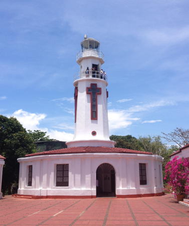
1950 (station established 1835). Active; focal plane 193 m (633 ft); three white flashes every 20 s. 14.5 m (48 ft) octagonal cylindrical stone tower with lantern and double gallery, rising from the center of 1-story stone keeper's house. Windows on the four sides of the tower are arranged in the shape of crosses, and light shines through them at night. Buildings painted white. Raywollesen Fortes's photo is at right, Martinez has a page for his visit, Laz'andre Cawagas has a good closeup, Wikimedia has numerous photos, and Google has a street view and a satellite view. Wikimedia also has an 1893 historic photo. Corregidor, a rocky island in the entrance to Manila Bay, is famous for the heavily armed fortress where American troops resisted Japanese invaders for five months until forced to surrender in May 1942. The lighthouse was heavily damaged during the war; Lighthouse Digest has a 1945 photo showing the damage. In recent years this historic light station was restored with funds from the Spanish government and the lantern was replaced with modern equipment by the Japanese government. The Pacific War Memorial is nearby. Located at the highest point of the island, known as Topside. Site and tower open. . ARLHS PHI-021; PCG-0045; Admiralty F2634; NGA 14272.
Calungpang Point (Ternate)
Date unknown. Active; focal plane unknown; green flash every 5 s. White concrete tower (described only as a "concrete structure"). Arvie Hernandez has a very distant view (light atop the ridge at right) and Google has a satellite view. Located on a very sharp point on the south side of the entrance to Manila Bay, opposite Corregidor. Site status unknown. PCG-0062; Admiralty F2634.5; NGA 14274.
[El Fraile (Fort Drum)]
2001. Active; focal plane about 15 m (49 ft); white flash every 5 s. Approx. 6 m (20 ft) hexagonal white concrete post with gallery. Kymnerfe Balang has a photo, Patrick Villaflores has another view, an aerial photo (just over halfway down the page) is available, and Google has a satellite view. The tiny islet of El Fraile (The Friar) was covered in concrete before World War II and armed with guns from a ship so that it resembles a warship from the air. Located about 3 km (2 mi) off the south side of the entrance to Manila Bay, south of Corregidor. Accessible only by boat. Site open, tower closed. PCG-0046; Admiralty F2635; NGA 14276.
* [Puerto Azul (2)]
Date unknown. Active; focal plane unknown; green flash every 5 s. Approx. 5 m (16 ft) mast on a white tripod base. Jay Patron has a closeup street view and Google has a satellite view. This small light replaced a concrete tower still described by PCG. Located on a headland on the east side of a small protected harbor on the south coast of Manila Bay. Site open, tower closed. PCG-0061; Admiralty F2635.5; NGA 14280.

Corregidor Light, Manila Bay, May 2018
Wikimedia Creative Commons photo by Raywollesen Fortes
San Nicholas Shoal (4?)
1997 (station established 1880). Replaced by a buoy in 2022. 11 m (36 ft) red post mounted on a square concrete platform supported by piles. Trabas has Arndt's photo but the light is not seen in Bing's satellite view. This is a historic light station. The original prefabricated iron tower was overthrown by a typhoon in August 1881. The Spanish built a second tower on the shoal late in their administration; U.S. authorities put it in service in 1905 and replaced it with (probably) a sturdier tower in 1914. Located on a shoal on the south side of Manila Bay about halfway between Corregidor and Cavite. Accessible only by boat. Site open, tower closed. ARLHS PHI-055; PCG-0047; ex-Admiralty F2643; NGA 14284.
* Cavite (Naic)
2014. Active; focal plane 15 m (49 ft); two white flashes every 5 s. Approx. 13 m (43 ft) round cylindrical tower; a spiral stairway winds around the tower. Entire lighthouse is white. Raymund Bergantin has a 2024 photo, Janine Dioso has a photo, Jhay Adriano has a closeup photo, Israel Garcia has a distant street view, and Google has a satellite view. Located next to the Bancaan Fish Port on the Cavite waterfront. Site open, tower closed. PCG-0828; Admiralty F2644; NGA 14282.
Sangley Point
Date unknown. Active; focal plane 37 m (121 ft); white flash every 10 s. 40 m (131 ft) square skeletal tower painted with red and white horizontal bands. No photo available but Google has a satellite view. The peninsula of Sangley Point shelters the Cavite Naval Base and includes a airstrip. The Directory usually does not list aeronautical beacons, but this one functions also as a marine navigational beacon. Located near the tip of the peninsula. Site and tower closed (military reservation). PCG-0049; Admiralty F2647; NGA 14288.
San Antonio (2?)
Date unknown. Listed as active; focal plane 11 m (36 ft); two red flashes every 3 s. This was an 11 m (36 ft) concrete tower on a square platform located in Canacao Bay south of the Cavite naval base. No photo available and the light is no longer seen in Google's satellite view. In December 2023 the Admiralty announced the light with a new onshore location, seen in this satellite view. Perhaps the light was moved to an existing communications tower. Site status unknown. Admiralty F2645.8; NGA 14287.3.

Laguna and Rizal Provinces: Laguna de Bay Lighthouses
Laguna de Bay is a large freshwater lake on the southeast side of Manila. With an elevation of about 2 m (6.5 ft) above sea level, the lake drains to Manila Bay through the Pasig River. It is named for the town of Bay (or Bae) located on the south shore of the lake.

*
Calamba (Lingga)
2005. Active; focal plane about 12 m (39 ft); white flash every 5 s. Approx. 9 m (30 ft) round barbell-shaped white tower. Hgen Hara has a photo, Google has a street view and an indistinct satellite view. Located in Laguna Province adjacent to the Coast Guard station just south of the jetty at Calamba, on the southwest shore of the lake. Site open, tower closed. Admiralty F2651.
* Tanay (2)
2018. Active; focal plane about 12 m (39 ft); white flash every 5 s. Approx. 9 m (30 ft) slender square concrete tower with an external concrete stairway winding around the tower. Romeo Sto. Tomas II has the 2022 drone view seen at right, Ester Cahongcoy has a 2017 closeup photo, another 2017 photo is available, and Google has a satellite view and a distant street view. Located on a platform next to the pier at Tanay, in Rizal Province on the north shore of the lake. Site open, tower closed. . PCG-0060; Admiralty F2672.9.
Morong-Rizal
Date unknown. Active; focal plane about 25 m (82 ft); white flash every 5 s. Approx. 20 m (66 ft) white concrete tower with an external concrete stairway winding around the tower. A 2021 photo and a more distant view are available, Chris Bernardo also has a photo and Google has a satellite view. This light is official but its navigational value is slight. Located on the Morong River about 800 m (1/2 mi) north of Laguna de Bay. Site and tower probably open but no closeup photos were found. Admiralty F2672.95.

Tanay Light, Laguna de Bay, December 2022
Google Maps photo by Romeo Sto. Tomas II

National Capital Region (Metro Manila) Lighthouses

City of Taguig: Laguna de Bay Lighthouse
Napindan (Napindam)
2005. Active; focal plane 9 m (30 ft); red flash every 5 s. 9 m (30 ft) round concrete tower attached to an equipment shelter and mounted on a concrete pier. The Taguig Heritage Society has a 2020 photo, a closeup video is available, and Google has a satellite view. Located just off an island near the entrance to the Pasig River from the Laguna de Bay. Accessible only by boat. Site open, tower closed. PCG-0645; Admiralty F2650; NGA 14304.

City of Manila Lighthouses
Manila Yacht Basin (Jetty No. 4)
Date unknown. Active; focal plane 11 m (36 ft); red flash every 5 s. 8 m (26 ft) square cylindrical white concrete tower. Trabas has Arndt's photo, another photo is available, and Google has a satellite view. Located at the end of the curved breakwater of the yacht basin on the south side of downtown Manila. Site and tower closed. PCG-0051; Admiralty F2662; NGA 14296.
[Manila West Breakwater (2)]
Date unknown. Active; focal plane 12 m (39 ft); green flash every 5 s. 10.5 m (34 ft) steel post. Post painted green. Trabas has Arndt's photo and Google has a satellite view. Christian Lucas Sangoyo has a distant 2008 photo of the earlier light, which stood on a pyramidal concrete base. The breakwater was shortened by 90 m (295 ft) in 2022. Located at the end of the west breakwater of the harbor, just south of the mouth of the Pasig River. Accessible only by boat (the breakwater is not walkable). Site open, tower closed. PCG-0054; Admiralty F2654; NGA 14316.
HPCG Wharf (Philippines Coast Guard)
Date unknown. Active; focal plane 32 m (105 ft); white flash every 10 s. 30 m (98 ft) steel mast. Joey Lazarta has a street view from a nearby cruise ship and Google has a satellite view. This light stands in front of the national headquarters building of the Philippines Coast Guard. Site and tower closed. PCG-0797; Admiralty F2653.5; NGA 14321.
* Manila Customs House
Late 1930s? Inactive since 2020. Light mounted atop the central tower of the Customs House. A 2019 photo is available, Joey Lazarta has a distant street view from a cruise ship, and Google has a satellite view and a distant street view. According to the Philippine Star the Customs House is a Neoclassical building designed by the architect Antonio Toledo in the late 1930s. John Tewell has a historic photo from the late 1940s. Located on the Manila waterfront on the Muelle San Francisco about 800 m (1/2 mi) south of the Pasig River. Site open, tower status unknown. ARLHS PHI-117; ex-PCG-0055; ex-Admiralty F2653; NGA 14320.
* Pasig River (3)
1992 (station established 1642). Active; focal plane 13 m (43 ft); white flash every 5 s. 14 m (46 ft) round concrete block tower with lantern and gallery. The Philippines Coast Guard station for Manila is adjacent to the lighthouse. A 2023 photo by Joseph Emmanuel Magallanes is at right, Stephen Wong contributed a good 2010 photo, Martinez has a page with photos and comments from his 2014 visit, David Montasco has a photo, Trabas has Darlene Chisholm's closeup photo, and the lighthouse is centered in Google's satellite view. This is the oldest light station in the Philippines. The present tower replaced an elegant Spanish tower built in 1846; Klaus Huelse has posted a postcard view of that lighthouse, and Wikipedia's article has two historic photos. The historic lighthouse was demolished in 1992 (a great loss) but the new tower is built on the base of the old one, according to Manuel Noche. Located on the dike on the north side of the entrance to the river from Manila Bay. The location is downstream from downtown Manila but upstream from the main port area, next door to a shantytown neighborhood called Parola. Site open, tower closed. ARLHS PHI-095; Admiralty F2669; NGA 14324.

Pasig River Light, Manila, May 2023
Google Maps photo by Joseph Emmanuel Magallanes

Central Luzon Region Southwest Coast Lighthouses

Bulacan Province Lighthouses
Bulacan Province faces south on the north shore of Manila Bay.

*
Binuangan
2015. Active; focal plane 18 m (59 ft); two white flashes every 5 s. 16 m (52 ft) square solid concrete tower with a staircase spiralling around the tower. Entire lighthouse is white. A 2022 photo by Lenlen Gatus is at right, another photo and a third photo are available, Jesse Marcos has a 2024 closeup, and Google has a satellite view. Note: there is another Binuangan Light in Northern Mindanao. Located on the waterfront in Binuangan, a fishing village in the Obando municipality, 16 km (10 mi) north of Manila. PCG-0829; Admiralty F2642.5.
* Pamarawan
Date unknown Active; focal plane about 11 m (36 ft); two white flashes every 8 s. 10 m (33 ft) square tapered skeletal tower. Arjames Dailo has a street view but the spidery tower is hard to see in Google's satellite view. Located on the waterfront of Pamarawan, a village on the north shore of Manila Bay. Site open, tower closed. PCG-0537; Admiralty F2642.4; NGA 14335.
#Pugad River (1)
1930s(?). Reported inactive since about 2005 and replaced in 2020. This was an approx. 13 m (43 ft) round concrete tower. A 2012 photo is available and Google has a satellite view. Battered by waves, the lighthouse developed an obvious lean. After many years of requests by local officials the Coast Guard replaced the leaning tower with a light on a tall mast in September 2020 (focal plane about 12 m (39 ft); white flash every 5 s). Located off the mouth of the Pugad River in the northernmost section of Manila Bay. Accessible only by boat. Site open, tower closed. Active light: Admiralty F2642.2.

Binuangan) Light, Obando, July 2022
Google Maps photo by Lenlen Gatus

Bataan Province: Manila Bay Lighthouses
Bataan Province occupies the mountainous Bataan Peninsula, which projects southward separating Manila Bay from the West Philippine (South China) Sea.
* Lamao Point
2016. Active; focal plane about 20 m (66 ft); two white flashes every 6 s. 18 m (59 ft) square cylindrical tower with an external stairway winding around the tower. Entire lighthouse is white. Erwin Ali has a photo, Anthony Dizon has a 2021 photo, an aerial photo is available, and Google has an indistinct satellite view. Located on the ferry quay at Lamao on the east coast of the Bataan Peninsula. Site open, tower closed. Admiralty F2639.5.
* Sisiman Cove (Gorda Point, San Miguel) (2)
2015. Active; focal plane about 20 m (66 ft); white flash every 5 s. Approx. 14 m (46 ft) square concrete tower with an external stairway winding around the tower. Entire lighthouse is white. Jap Salem's December 2013 photo shows that the tower was completed by then but the light had not been installed. It was finally activated in August 2015. A photo by Joel Cortez is at right, Agnes Bofill has a 2019 photo, Myk Maspogi has a drone view, and Google has a satellite view. The original light, an 11 m (36 ft) concrete post light with an external stairway spiraling around the tower, collapsed in 2011 due to beach erosion. Keith Kennedy visited this site on 30 October 2011 and found only ruins of the light; it fell sometime after Apol Seban's photo of 29 August 2011. Built on the southern tip of the Bataan Peninsula, this light marks the east side of the entrance to the bay of Mariveles. The new light is about 80 m (260 ft) north of the original location. Site open, tower closed. . ARLHS PHI-119; PCG-0043; Admiralty F2631; NGA 14270.
Mariveles
Date unknown. Active (?); focal plane 12 m (40 ft); two green flashes every 10 s. 11 m (36 ft) white concrete tower. Google has a street view and the light is to the left of the tree in Google's satellite view. Located near the foot of the original pier on the historic waterfront of Mariveles. Site open, tower closed. ARLHS PHI-118; PCG-0042; Admiralty F2630; NGA 14268.

Bataan Province: Subic Bay Lighthouses (see also Northwest Luzon)
* [Mayagao Point (Morong)]
Date unknown. Active; focal plane unknown; white flash every 5 s. Approx. 9 m (30 ft) square white concrete post topped by a short skeletal mast. Google has a street view but the small light is not seen in Google's satellite view. The municipality of Morong occupies the northwestern base of the Bataan Peninsula and the southeastern side of Subic Bay. Located one block off the waterfront of Morong. Site open, tower closed. Admiralty F2672.98; NGA 14365.

Sisiman (Gorda Point) Light, Mariveles, April 2018
Google Maps photo by Joel Cortez
Grande Island (2?)
Date unknown (station established 1903). Active; focal plane about 25 m (82 ft); two white flashes every 10 s. Approx. 20 m (66 ft) square skeletal tower with gallery. No photo available but Google has a satellite view. Grande Island, about 1.5 km (1 mi) long, is located in the center of Subic Bay. The light is at the northwestern tip of the island. Accessible only by boat. Site status unknown. Admiralty F2675.8; NGA 14366.
Boton Wharf Range Front
 
Date unknown. Active; focal plane about 20 m (66 ft); continuous red light. Approx. 15 m (49 ft) square skeletal tower painted with red aand white horizontal bands and carrying a triangular daymark. Google has a 2024 street view and a satellite view of the range lights (the front light is on the right in the street view and toward the top of the satellite view). Located in the Subic Bay Terminal south of Olangapo. Site and tower closed. PCG-0793; Admiralty F2675.9.
Boton Wharf Range Rear
 
Date unknown. Active; focal plane about 30 m (98 ft); continuous red light. Approx. 25 m (82 ft) square skeletal tower painted with red aand white horizontal bands and carrying a triangular daymark. Google has a 2024 street view and a satellite view of the range lights. Located in the Subic Bay Terminal south of Olangapo. Site and tower closed. PCG-0794; Admiralty F2675.95.

Information available on lost lighthouses:

Notable faux lighthouses:

Adjoining pages: North: Northwest Luzon | Southeast: Southeast Luzon | South: Romblon and Marinduque | Southwest: Mindoro

Return to the Lighthouse Directory index | Ratings key

Created July 24, 2005. Checked and revised October 7, 2024. Lighthouses: 47. Site copyright 2024 Russ Rowlett and the University of North Carolina at Chapel Hill.