Lighthouses of Australia: Northern and Central Queensland

The independent Commonwealth of Australia occupies the entire Australian continent, the island of Tasmania, and numerous smaller islands. British exploration and settling of the continent began late in the 1700s, with the first colony established in the Sydney area in 1788. By the 1850s there were six British colonies, including New South Wales and Queensland in the east, Victoria and South Australia in the south, Western Australia in the west, and Tasmania off the south coast. The Commonwealth was formed on New Years Day 1901 as a federation of the six colonies.

Australia is both the smallest continent and the sixth-largest country in the world, with a population of about 26 million. It continues to be a federation of the six original states, plus the federally administered Northern Territory, Australian Capital Territory, and Jervis Bay Territory. It is a Commonwealth Realm recognizing the British monarch as head of state.

Queensland, the state occupying the northeastern quarter of Australia, has a long tropical coastline facing the Coral Sea (a basin of the Pacific Ocean) and fringed in large part by the famous Great Barrier Reef, the world's largest coral reef system. This coastline ends at Cape York, the northernmost point of the Australian continent. Beyond Cape York the Torres Strait separates Australia from New Guinea and provides a passage from the Coral Sea to the Arafura Sea (the easternmost arm of the Indian Ocean).

This page includes lighthouses of the Coral Sea coast from the Townsville region south through the Gladstone region. For the Cape York Peninsula lighthouses see the page for Queensland's Far North and for lighthouses south of the Gladstone region see the Southern Queensland page.

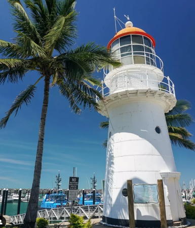
Most of the older lighthouses in Queensland are wood frame towers covered by iron sheets, like the Cape Cleveland Light at right. These towers were built in the late 1800s when there was a need to build a great many lighthouses on the Queensland coast as quickly as possible. Remarkably, at least 16 of these inexpensive lighthouses have survived to the present and 9 remain active.

Coastal lighthouses in Australia are operated by the Australian Maritime Safety Authority (AMSA) but after automation AMSA transferred many of the station properties to the control of local or state authorities or organizations.

ARLHS numbers are from the ARLHS World List of Lights. Admiralty numbers are from volume K of the Admiralty List of Lights & Fog Signals. U.S. NGA numbers are from Publication 111.

General Sources
Lighthouses of Queensland
The section of the Lighthouses of Australia site devoted to Queensland lights.
AMSA Heritage Lighthouses
An interactive map links to information and photos for the major AMSA lighthouses.
Lighthouses and Lightvessels in Australia - Queensland
Index to Wikipedia articles; most include photos.
World of Lighthouses - Queensland
Photos by various photographers available from Lightphotos.net.
Leuchttürme in Australien
Photos posted by Andreas Köhler.
Online List of Lights - Australia - East Coast
Photos by various photographers posted by Alexander Trabas. Many of the photos for Queensland are by Michael Boucher.
Queensland State Map
From the Encyclopædia Britannica.
GPSNauticalCharts
Navigation chart information for the Queensland coast.


Cape Cleveland Light, Townsville, June 2022
Instagram photo by I Grew Up In Townsville
Palm Passage Lighthouses
Pith Reef
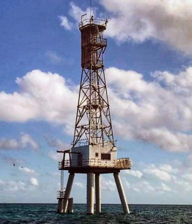
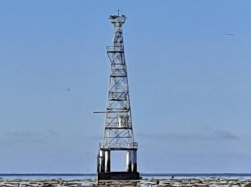
1979. Active; focal plane 28 m (92 ft); three white flashes every 15 s. 28 m (92 ft) square skeletal tower mounted on a square platform supported by piles. Trevor Aston's 2020 photo is at right, Steve Swayne has a 1984 photo, and Bing has a satellite view. The reef is a popular destination for scuba divers. This light and the next one guide vessels through the Palm Passage, a narrow break in the Great Barrier Reef that allows ships to reach Lucinda and Townsville. Located on the Great Barrier Reef about 80 km (50 mi) east of Lucinda. Accessible only by boat. Site open, tower closed. Operator/site manager: AMSA. Admiralty K3120.5; NGA 10004.
Rib Reef
Date unknown. Active; focal plane 9 m (30 ft); two white flashes every 8 s. 9 m (30 ft) white fiberglass lantern structure atop a concrete "column." No photo available but Google has a satellite view. Located about 30 km (19 mi) southwest of the Pith Reef Light at the western entrance to the Palm Passage. Accessible only by boat. Site open, tower closed. Operator/site manager: AMSA. Admiralty K3120.7; NGA 10008.

Shire of Hinchinbrook Lighthouses
#Lucinda Point Range Rear
Date unknown (station established 1897). Removed. This was a 21 m (69 ft) square pyramidal skeletal tower carrying a large triangular daymark. Google has a 2007 street view but Google's satellite view confirms that the tower was removed after the front light was converted to a directional light. The tower was near the base of Lucinda's famous 5.7 km (3.6 mi) long jetty, the world's largest bulk sugar loading facility.The front light is a small tower on the jetty. Located in Lucinda, a small town 115 km (72 mi) northwest of Townsville. Site open. ex-Admiralty K3124.1; NGA 10016.

Pith Reef Light, Great Barrier Reef, August 2020
Google Maps photo by Trevor Aston
* Forrest Beach (Allingham)
Date unknown. Active; focal plane about 35 m (115 ft); white flash every 2.5 s. 33 m (108 ft) round water tower painted white. Google has a street view and a satellite view. Located at Leichhardt and Wattle Streets in Forrest Beach, a beach town about 85 km (53 mi) northwest of Townsville. Site open, tower closed. Operator/site manager: unknown. Admiralty K3119; NGA 10026.
Albino Rock
Date unknown. Active; focal plane 26 m (85 ft); three white flashes every 20 s. 5 m (16 ft) square white concrete tower. Google has a satellite view. Located on a rocky islet at the extreme southeast end of the Palm Islands, southeast of Lucinda and about 50 km (30 mi) north of Townsville. Accessible only by boat. Site open, tower closed. Admiralty K3120; NGA 10028.

City of Townsville Lighthouses
Townsville is the largest city of northern Queensland with a population of more than 200,000.

Sea Channel Range Front
Date unknown. Active; focal plane about 15 m (49 ft); quick-flashing white light; also a passing light (red flash every 4 s). Approx. 15 m (49 ft) square skeletal tower mounted on a platform supported by a single robust concrete pile. Trabas has Boucher's distant view but the light is not shown in Google's satellite view. This is the initial approach range for Townsville; ships follow this range and then the Platypus Channel Range (see below). Located about 3 km (2 mi) southeast of the southern tip of Magnetic Island, northeast of Townsville. Accessible only by boat. Site open, tower closed. Admiralty K3097; NGA 10056.
Sea Channel Range Rear
Date unknown. Active; focal plane about 30 m (98 ft); white light, 1 s on, 1 s off; also a passing light (two white flashes every 6 s). Approx. 30 m (98 ft) square skeletal tower mounted on a platform supported by a single robust concrete pile. Trabas has Boucher's distant view but the light is not shown in Google's satellite view. This is the initial approach range for Townsville. Located about 3 km (2 mi) southeast of the southern tip of Magnetic Island, northeast of Townsville. Accessible only by boat. Site open, tower closed. Admiralty K3097.01; NGA 10060.
* Bay Rock (1) (relocated to Townsville)
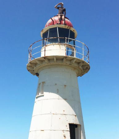
1886. Inactive since 1990. 8 m (26 ft) wood frame tower covered by galvanized iron sheets, with lantern and gallery. Lighthouse painted white; lantern dome is red. Tony Gordon's 2019 photo is at right, Wikipedia has an article including a historic photo and Mark McIntosh's closeup photo, Köhler has a photo, a 2021 photo is available, and Google has a closeup street view and a satellite view. This lighthouse was originally located atop a rocky islet on the northwest side of Magnetic Island about 20 km (13 mi) north of Townsville (a Google satellite view shows the location); it was replaced there by a small fiberglass beacon. In 1992 it was relocated to the Townsville Maritime Museum, where it was restored by Queensland Transport. The museum was expanded and refurbished in 2001; it exhibits a collection of Fresnel lenses from the former Penrith Island, Albino Rock, Heath Reef, and Duyfken Point lighthouses. Located on the south side of Ross Creek near downtown Townsville. Site open; museum open daily. Owner/site manager: Townsville Maritime Museum. . ARLHS AUS-266; ex-Admiralty K3117.

Bay Rock Light, Townsville, September 2019
Google Maps photo by Tony Gordon
* Platypus Channel Range Rear (Max Hooper) (2)
Date unknown. Active; focal plane 20 m (66 ft); continuous blue light; also a red light, 1 s on, 1 s off, and in the daytime a continuous white light. Approx. 18 m (56 ft) steel tower painted white. Trabas has Boucher's photo, a 2020 photo is available, and Google has a street view and a satellite view. This is the entrance range for Townsville. The Townsville Maritime Museum also has a collection of two former range light towers; a street view shows them standing near the present light. The modern light is a sibling of the Bribie Island Rear Light at Caloundra (see the Southern Queensland page). Trabas has Boucher's photo and Uwe Mertens has a street view of the front light, which is on a post beside the entrance channel to the harbor. Located about 100 m (110 yd) east of the historic Bay Rock Light (previous entry). Site open, tower closed. Admiralty K3100.1; NGA 10062.1.
* Wharton Reef (1) (relocated to Townsville)
1915. Inactive since 1990. Approx. 9 m (30 ft) square steel skeletal tower with lantern and gallery, painted bright red. Wikipedia has an article on the lighthouse, Shantelle Hardman has a closeup photo, Köhler has a photo, and Google has the 2019 street view at right and a satellite view. The lighthouse was originally 15 m (50 ft) high and mounted on concrete piers on Wharton Reef in Princess Charlotte Bay off the Cape York Peninsula (Bing has a satellite view of the location). It is the only survivor of a series of 20 acetylene-burning automatic lights built along the northern inside passage (inside the Great Barrier Reef) between 1915 and 1920. After it was replaced with a modern fiberglass light it was donated to the Townsville Maritime Museum and located since 1996 in the middle of a traffic roundabout at Palmer and Plume Streets, near the museum. Site open, tower closed. Owner: Townsville Maritime Museum. Site manager: Townsville City Council. ARLHS AUS-265; ex-Admiralty K3226.
 

Wharton Reef Light, Townsville, October 2019
Google Maps street view
 
Cape Cleveland
1879. Active; focal plane 64 m (210 ft); white flash every 7.5 s; a red flash is shown in a sector over Four Foot Rock. 11 m (36 ft) wood frame tower covered by galvanized iron sheets, with lantern and gallery. Lighthouse painted white; lantern dome is red. Two 1-story keeper's houses and other light station buildings. A 2022 photo is at the top of this page, James Steed has a 2019 photo, a 2008 photo is available, Kevin Mulcahy has a photo, John Lorime has a closeup 2017 street view, and Google has a satellite view. Not be confused with the Point Cleveland Light in Redland (see the Southern Queensland page). This was formerly the rear light of a range, but the range has been discontinued. Cape Cleveland is a long, narrow promontory projecting northward into the Coral Sea about 40 km (25 mi) east of Townsville. Located on the point of the cape. Accessible only by boat or helicopter. Site and tower closed. Operator/site manager: AMSA. . ARLHS AUS-027; Admiralty K3092.1; NGA 10096.
* [Cape Ferguson (Chunda Bay)]
Date unknown. Active; focal plane 7 m (23 ft); white flash every 4 s. 4 m (3 ft) square skeletal tower. No photo available but Google has a satellite view. Located on a breakwater sheltering a bay on the east side of Cape Cleveland. Accessible by walking the pier. Site open, tower closed. Admiralty K3091; NGA 10104.

Shire of Burdekin Lighthouse
Cape Bowling Green (3)
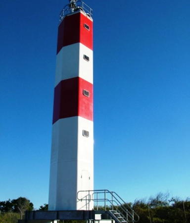
2008 (station established 1874). Active; focal plane 20 m (66 ft); four white flashes every 20 s. 13 m (43 ft) hexagonal cylindrical fiberglass tower colored with red and white horizontal bands. CivilPlus Constructions, the contractor that installed the new Cape Bowling Green lighthouse, has two photos including the one at right, another photo is available (a little over halfway down the page) and Google has a satellite view. Sibling of the 2006 Clerke Island lighthouse off Cape Grenville in the Far North. The original lighthouse, a 16 m (52 ft) iron tower, was replaced in 1987 by a 32 m (105 ft) square cylindrical steel skeletal tower with a square lantern structure and gallery. The historic lighthouse was dismantled and relocated to the Australian National Maritime Museum at Darling Harbour in Sydney (see Southern New South Wales). Cape Bowling Green is a lengthy promonotory, ending in a long, trailing sand spit, about 30 km (19 mi) north of Ayr. Located at the end of the higher portion of the promontory, near the base of the spit. Site open, tower closed. Site manager: Queensland National Parks (Bowling Green Bay National Park). ARLHS AUS-023; Admiralty K3090; NGA 10108.

Cape Bowling Green Light, Townsville, 2008
photo copyright CivilPlus Constructions

Whitsunday Region (Bowen Area) Lighthouses
Bowen is a town of about 11,000 residents halfway between Townsville and Mackay.

Abbot Point East Approach Range Rear
1984 (?). Active; focal plane 55 m (180 ft); white flash every 4 s. Hayden Smedley has a 2024 photo and Bing has a satellite view. The light is mounted on a water tower. Tower painted white. Abbot Point is a large coal shipping port completed in 1984. Located on a bluff above the port, about 25 km (15 mi) north of Bowen. Site and tower closed. Owner/site manager: North Queensland Bulk Ports Corp. Admiralty K3082.9; NGA 10125.4.
North Head Island (Bowen, Port Denison)
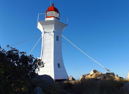
1867. Inactive since 1985. Approx. 11 m (35 ft) tapered hexagonal wood lighthouse with lantern and gallery, painted white; lantern dome is red. The original Fresnel lens is displayed at the Bowen Historical Society and Museum . A photo is at right, a 2020 photo and a 2009 photo are available, Bryan Martin has a 2010 photo, Chris Smith has a view from the sea, and Google has a satellite view. This is the original lighthouse, seen in an 1876 photo, although the gallery has been altered. This historic lighthouse has been rediscovered by the public after several decades of neglect. A committee was formed in Bowen to work for restoration of the lighthouse and an engineering study was launched in 2013. In April 2016 the Whitsunday Regional Council appropriated $100,000 to restore the lighthouse in time for its 150th anniversary; the project was completed on time in August 2017. It's possible to walk to the lighthouse at lowest tides and an annual Walk to the Lighthouse is held every August. Located on North Head Island, a rocky island about 5 km (3 mi) east of Bowen. The active light (next entry) is located on Stone Island, a larger island to the southeast, on the other side of the Port Denison entrance channel. Normally accessible only by boat. Site open, tower closed. Owner/site manager: Whitsunday Regional Council. . ARLHS AUS-242.
Stone Island (Sinclair Head)
1985. Active; focal plane 26.5 m (87 ft); white flash every 4 s. Approx. 5 m (16 ft) white fiberglass tower. No photo available but Google has a satellite view. Located at the eastern tip of Stone Island southeast of Bowen. Accessible only by boat. Site open, tower closed. Admiralty K3070, NGA 10133.
 

North Head Light, Bowen, 2018
Whitsunday Regional Council photo (no longer online)
 
Dent Island
1879. Active; focal plane 37 m (127 ft); white flash every 5 s. 10 m (33 ft) wood frame tower covered by galvanized iron sheets, with lantern and gallery. Lighthouse painted white; lantern dome is red. Several 1-story keeper's houses are now privately owned. David Christie's 2024 photo is at right, Trabas has Jim Smith's 2012 photo, Wikipedia has an article that includes J. Warnes's 2007 aerial photo, an AMSA photo is available, Judy Rossiter has a distant 2024 view, and Google has a satellite view. Dent Island is one of the smaller islands of the Whitsunday Islands east of Cannonvale. Neighboring Hamilton Island has a settlement and airstrip, but Dent Island is privately owned. Located on the west side of the island, marking the Dent Island Passage. Accessible only by boat. Site and tower closed (private). Operator/site manager: AMSA. . ARLHS AUS-188; Admiralty K3064; NGA 10204.

Hydrographer's Passage Lighthouses
The Hydrographer's Passage is a 100 km (60 mi) long passage through the heart of the Great Barrier Reef. The Passage was surveyed by the Royal Australian Navy in 1981 to provide a direct connection between Mackay and other north Queensland ports and the Coral Sea. The route was opened to navigation in 1984 but ships using it must be guided by licensed pilots.

White Tip Reef Range Front
1985. Active; focal plane 10 m (33 ft); white or red light depending on direction, 2.5 s on, 2.5 s off. 12 m (39 ft) lantern mounted on a square equipment shelter on a square platform supported by robust concrete piles. Equipment shelter painted red. No photo available but Bing has a satellite view. This is the inbound entrance range for the Hydrographer's Passage. Located near the outer edge of the barrier reef about 170 km (105 mi) northeast of Mackay. Accessible only by boat. Site and tower closed. Admiralty K3054; NGA 10231.

Dent Island Light, Whitsunday Islands, May 2024
Google Maps photo by David Christie
White Tip Reef Range Rear
1985. Active; focal plane 37 m (121 ft); white flash every 10 s. 37 m (121 ft) skeletal tower on a concrete pile structure. The tower also carries a large orange square daymark facing the range line. No photo available but Bing has a satellite view. Located about 2 km (1.25 mi) south southwest of the front light. Accessible only by boat. Site and tower closed. Admiralty K3054.1; NGA 10231.1.
Bond Reef
1980s. Active; focal plane 9 m (30 ft); nine quick white flashes every 15 s. No description available; tower painted yellow with one black horizontal band. No photo available but Bing has a satellite view. This light marks the east side of the Bond Entrance through the outer Great Barrier Reef. Located across the entrance from the White Tip Reef. Accessible only by boat. Site and tower closed. Admiralty K3053.5.
Little Bugatti Reef
1985. Active; focal plane 23 m (75 ft); flash every 5 s, white, red or green depending on direction. 22 m (72 ft) skeletal tower on a concrete pile structure. The tower also carries a large orange square daymark. No photo available but Bing has a satellite view. This leading light guides ships in the central section of the passage, through the most dangerous reefs. Located about 13 km (8 mi) south of the White Tip Reef Range Rear Light. Accessible only by boat. Site and tower closed. Admiralty K3053; NGA 10230.
Bugatti Reef
1980s. Active; focal plane 9 m (30 ft); two white flashes every 8 s. 10 m (33 ft) round cylindrical white concrete tower with gallery. Wikimedia has a photo by J. Warnes but the light is not seen in Google's fuzzy satellite view of the reef. This light marks a bend in the passage. Located about 10 km (6 mi) southeast of the Little Bugatti Reef Light. Accessible only by boat. Site and tower closed. Admiralty K3056; NGA 10229.5.
Creal Reef
1985. Active; focal plane 32 m (105 ft); white flash every 7.5 s. 31 m (102 ft) skeletal tower on a concrete pile structure. The tower also carries a large orange square daymark. A 2021 photo is at right and Wikimedia has a photo by J. Warnes but Google has only a fuzzy satellite view of the reef. This light guides both inbound and outbound ships in the Hydrographer's Passage. Located on a reef about 150 km (95 mi) east of Mackay. Accessible only by boat. Site and tower closed. Admiralty K3052; NGA 10229.

Creal Reef Light, Great Barrier Reef, February 2021
Google Maps photo by Cape Ships

Mackay Region Lighthouses
Mackay is a city of about 120,000 residents at the mouth of the Pioneer River.

Penrith Island
Date unknown. Active; focal plane 150 m (492 ft); three white flashes every 15 s. 4 m (13 ft) square masonry tower painted white. No photo available but Google has a satellite view of the station. A Fresnel lens from this lighthouse is on display at the Townsville Maritime Museum. Located on the summit of Penrith, a wilderness island located about 80 km (50 mi) east of Mackay. Site status unknown. Site manager: South Cumberland Islands National Park. ARLHS AUS-192; Admiralty K3049; NGA 10228.
Bailey Island (Bailey Islet) (2)
Date unknown (station established 1928). Active; focal plane 36 m (118 ft); white flash every 5 s. Approx. 7 m (23 ft) hexagonal cylindrical white tower. Bing has a satellite view. Located on a small island about 50 km (30 mi) northeast of Mackay. Accessible only by boat. Site status unknown. Admiralty K3048; NGA 10224.
** Pine Islet (1) (relocated to Mackay)
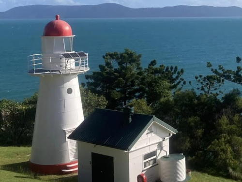
1885. Inactive since 1985. 10.5 m (35 ft) wood frame tower covered by galvanized iron sheets, with lantern and gallery. Lighthouse painted white; lantern dome is red. A 2024 photo is at right, a 2021 photo is available, Wikipedia has an article with a photo, and Google has a street view and a satellite view. This lighthouse was originally located on an island in the Percy Group about 130 km (80 mi) southeast of Mackay. After deactivation, the lighthouse was dismantled in 1986 and slated for relocation to the National Maritime Museum in Sydney. Mackay residents fought this idea and formed the Pine Islet Lighthouse Preservation Society to relocate the lighthouse to Mackay. After much public agitation the lighthouse was donated to the Society in 1989. Reassembled by volunteers, it has been on display since restoration was completed in 1995. The lighthouse has an operational kerosene-powered light. In 2004 the lighthouse was repainted by the Mackay Port Authority. In 2023 the Society was working to restore and relight the kerosene-powered optic. Located at Mackay Marina on the waterfront in Mackay Harbour. Site open; tours of the lighthouse available. Site manager: Pine Islet Lighthouse Preservation Society. . ARLHS AUS-127.
* Mackay Lee Breakwater (Forgan Smith Point)
1996. Active; focal plane 8 m (26 ft); green light, 1 s on, 1 s off. 5 m (16 ft) round conical concrete tower painted white with a green top. Trabas has Boucher's photo, Jess Bidstrup has a distant street view, and Bing has a satellite view. Located on the north (lee) breakwater of Mackay. Accessible by walking or driving the pier; there's parking available at the end. Site open, tower closed. Admiralty K3036; NGA 10260.

1885 Pine Islet Light, Mackay, July 2024
Instagram photo by Mantra Mackey
* Mackay Main Breakwater (Bagley Point)
1996. Active; focal plane 8 m (26 ft); red light, 1 s on, 1 s off. 5 m (16 ft) round conical concrete tower painted white with a red top. A photo is available, Trabas has Boucher's photo, Scott Burrage has a street view, and Bing has a satellite view. The light has a plaque in memory of Charles F. Bagley, longtime chairman of the Mackay Harbour Board. Located on the south (main) breakwater of Mackay. Accessible by walking or driving the pier; there's parking available at the end. Site open, tower closed. Admiralty K3035; NGA 10268.
Flat Top Island (2)
1879 (station established 1874). Inactive since 2007. 10 m (32 ft) wood frame tower covered by galvanized iron sheets, with lantern and gallery, painted white; lantern dome is red. Carl Telsa's 2017 photo is at right, a 2017 view from the sea is available, Wikipedia has an article with a historic photo, and Google has a satellite view. This light became unnecessary when the modern Mackay Harbour was developed about 4 km (2.5 mi) to the north. Clearly endangered; no plans to relocate or conserve this historic and deteriorated lighthouse have been announced. Apparently the island is rarely visited. Located on a rugged island off the entrance to the Pioneer River. Accessible only by boat. Site status unknown. Site manager: Yuwi Paree Toolkoon National Park. Operator: AMSA. . ARLHS AUS-190; ex-Admiralty K3028; ex-NGA 10232.
* Hay Point Lookout
Date unknown. Active; focal plane 78 m (256 ft); two white flashes every 10 s. Light mounted on the 2-story harbor control building of the Hay Point Coal Terminal. Helene St. Clair has a photo and Google has a street view and a satellite view. Hay Point, located about 40 km (25 mi) southeast of Mackay, is one of the world's largest coal terminals. The harbor control building includes exhibits and an observation deck; parking is provided. Located on a steep ridge overlooking the terminals. Site open, tower closed. Owner/site manager: North Queensland Bulk Ports Corp. Admiralty K3024; NGA 10282.

Isaac Region (Percy Isles) Lighthouses
[Pine Peak Island]
Date unknown. Active; focal plane 46 m (151 ft); two white flashes every 6 s. 3 m (10 ft) tripod on a concrete base resting on a large white rock; connected by a ladder to a small equipment cabinet beside the rock. Wikimedia has a photo by J. Warnes and Google has a satellite view. Located on a high, forested island about 100 km (60 mi) southeast of Mackay. Accessible only by boat. Site open, tower closed. Operator/site manager: AMSA. Admiralty K3022; NGA 10292.

Flat Top Island Light, Mackay, March 2017
Instagram photo by Carl Telsa
Pine Islet (2) (Percy Isles)
1985 (station established 1885). Apparently inactive. This is (or was) a 6 m (20 ft) round fiberglass tower; no lantern. The 1-story keeper's house, painted white with a green roof, survives at this historic light station. No photo available but Google has a distant satellite view. In 2015 AMSA announced that the light had been relocated about 20 m (66 ft) northwest, but no notice of its deactivation has been found. Located in the Percy Isles about 130 km (80 mi) southeast of Mackay. Accessible only by boat. Site and tower closed. Operator/site manager: AMSA. ex-Admiralty K3020; ex-NGA 10304.

Swain Reefs and North Reef Lighthouses
Swain Reefs (Hixson Cay)
Date unknown. Active; focal plane 17 m (56 ft); white flash every 10 s. 17 m (56 ft) round square fiberglass tower mounted on a square platform supported by piles. Paul Hogger has a photo (halfway down the page) and Google has a satellite view. The Swain Reefs lie at the extreme southeastern end of the outer Great Barrier Reef. Located on a reef near the southern tip of the reefs. Accessible only by boat. Site open, tower closed. Admiralty K3014.5; NGA 10311.
North Reef
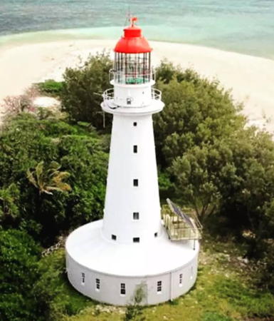
1878. Active; focal plane 23 m (75 ft); two white flashes, separated by 5 s, every 15 s. 24 m (78 ft) wood frame tower covered by galvanized iron sheets, with lantern and gallery; circular 1-story keeper's house, also wood frame covered by galvanized iron sheets, surrounds the base of the tower. Lighthouse painted white; lantern dome is red. A 2023 photo is at right, Wikipedia has an article with an aerial view by J. Warnes and another aerial view, and Bing has a distant satellite view. The reef was nearly awash when the lighthouse was built but it has since stabilized as a vegetated island. This light guides vessels around the south end of the Great Barrier Reef and also in the Capricorn Channel that parallels the coast inside the reefs. Located about 120 km (75 mi) northeast of Gladstone. Accessible only by boat. Site and tower closed. Operator/site manager: AMSA. . ARLHS AUS-122; Admiralty K3014; NGA 10312.

Rockhampton Region Lighthouses
Kazatch Point Range Rear (2)
Date unknown. Active; focal plane 13 m (43 ft); white light, 2 s on, 2 s off. 15 m (49 ft) square white skeletal tower carrying a white triangular daymark. No photo available but Google has a good satellite view. Ruins of the original tower lie next to the modern light. The range guides vessels approaching Port Alma, an Australian Navy ammunition depot on Casuarina Creek. The front range is on a similar 7 m (23 ft) tower. Located on the south side of Casuarina Creek east of Port Alma. Site status unknown. Admiralty K3010.1; NGA 10330.
Balaclava Island Range Front (2)
1932 (station established 1884). Active; focal plane 17 m (56 ft); quick-flashing white light. 17 m (56 ft) square pyramidal wood skeletal tower with gallery. Lighthouse painted white. The lighthouse also carries a triangular slatted daymark, point up, painted white with a black vertical stripe on the range line. No photo available but Google has a satellite view. The range guides vessels entering Keppel Bay and Fitzroy River. Located on the north shore of Balaclava Island and the south shore of Keppel Bay, about 60 km (36 mi) northwest of Gladstone, near Port Alma. Accessible only by boat. Site open, tower closed. Operator/site manager: unknown. ARLHS AUS-291; Admiralty K3002; NGA 10324.

North Reef Light, Great Barrier Reef, undated
Instagram photo posted by MV Cape Don/Moreton/Pillar
Balaclava Island Range Rear (2)
1932 (station established 1884). Active; focal plane 28 m (92 ft); white light, 1 s on, 1 s off. 27 m (89 ft) square pyramidal wood skeletal tower with gallery. Lighthouse painted white. The lighthouse also carries a rectangular slatted daymark, painted white, and a triangular slatted daymark, point down, painted white with a black vertical stripe on the range line. No photo available but Google has a satellite view. Located 1.6 km (1 mi) south southwest of the front light. Accessible only by boat. Site open, tower closed. Operator/site manager: unknown. ARLHS AUS-292; Admiralty K3002.1; NGA 10328.

Gladstone Region Lighthouses
Gladstone is a regional capital and seaport with a population of about 50,000.

Sea Hill (2) (Range Rear)
1895. Active; focal plane 33 m (108 ft); two white flashes every 6 s. Approx. 13 m (43 ft) round corrugated iron tower with lantern and gallery. Wikipedia has Peter Marquis Kyle's 2011 photo and Google has a satellite view. Endangered. The Internet has carried conflicting reports on the status and recent history of this lighthouse. There was a report that this lighthouse was deactivated in 2006 and another that it was demolished in 2009. Fortunately these reports were false. The lighthouse was granted State Heritage status in 2011. According to Wikipedia the lighthouse was standing but not active in 2014. Current and accurate information is needed! The lighthouse marked the east side of the entrance to Keppel Bay. It was accompanied by a pilot station, which closed in 1963. It supplemented an 1873 lighthouse now in the collection of the Gladstone Maritime Museum (see below). The two lighthouses functioned as a range until the 1920s; Wikipedia has a historic photo of the two towers in 1908. Located on a promontory at the northwestern point of Curtis Island. Site open. Site manager: Queensland National Parks (Curtis Island National Park). ARLHS AUS-196; Admiralty K3000; NGA 10320.
Cape Capricorn (3)
1964 (station established 1875). Active; focal plane 93 m (305 ft); flash every 5 s, white or red depending on direction. 7 m (23 ft) concrete block tower with gallery, painted white; lantern removed. The two 1-story keeper's houses were available for vacation rental, but it's not clear that this is still the case. Martin Devereaux has the 2018 photo at right, another photo shows the lighthouse after the removal of the lantern, Wikipedia has an article with a photo, and Google has a satellite view. The original corrugated iron tower was replaced by a concrete block lighthouse in 1938. Located on the northeast point of Curtis Island 24 km (15 mi) north of Gladstone. Accessible only by boat. Site and tower closed. Operator: AMSA. Owner/site manager: Queensland National Parks (Curtis Island National Park). ARLHS AUS-026; Admiralty K2992.1; NGA 10336.

Cape Capricorn Light, Curtis Island, February 2018
Google Maps photo by Martin Devereaux
Facing Island East Point
1980. Active; focal plane 47 m (154 ft); white flash every 10 s. 10 m (33 ft) square cylindrical skeletal tower with double gallery and a white fiberglass lantern structure. A photo is available and Google has a satellite view. Located atop a dune at the southeastern corner of Facing Island, which shelters the harbor of Gladstone. Site open, tower closed. Admiralty K2972; NGA 10352.
* Sea Hill (1) (Range Front) (relocated to Gladstone)
1873. Inactive since the 1960s. 6 m (20 ft) square corrugated iron tower with lantern and gallery. Lighthouse painted white, lantern dome red. One of Wayne Boyle's photos is at right, he also has a closeup, the Wikipedia article has Vicki Nunn's closeup photo, Daz Bambrick has a street view, and Google has a satellite view. This is apparently the oldest of Queensland's corrugated iron lighthouses. Originally located at the northwest point of Curtis Island, this small lighthouse was moved in the 1920s to Grassy Hill, at Station Point, about 6 km (3.5 mi) northeast. Deactivated in the 1960s, it was sold into private hands but later came into the possession of the Gladstone Maritime Museum. In 2014 the lighthouse was moved to a new display in the East Shore waterfront development project on Auckland Creek, a short distance west of the museum. Located on the quay next to the historic corvette HMAS Gladstone. Site open, tower closed. Owner/site manager: Gladstone Maritime Museum. .
Goldings Cutting Range Rear (2)
Date unknown. Active; focal plane unknown; continuous light, blue at night and white in the daytime. Approx. 18 m (59 ft) octagonal skeletal toiwer with enclosed upper section. No photo available but Google has a satellite view. This is the harbor entrance range for Gladstone. The front light is on a 7 m (23 ft) tower in the water 1.83 km (1.14 mi) southeast. The earlier light was a hexagonal metal tower mounted on a square platform supported by piles. Located in an industrial terminal on South Trees Island on the east side of Gladstone. Site and tower closed. Admiralty K2976.1; NGA 10384.
Boyne Island Cutting Range Front
Date unknown. Active; focal plane 20 m (66 ft); continuous light, blue at night and yellow in the daytime. 9 m (30 ft) square pyramidal skeletal tower carrying a white triangular daymark. Google has a street view and a satellite view. This is the second range for vessels approaching Gladstone. Located on Canoe Point in Tannum Sands on the southeast side of Gladstone. Site status unknown. Admiralty K2974; NGA 10372.

1873 Sea Hill Light, Gladstone, July 2018
ex-Google Plus photo by Wayne Boyle
Boyne Island Cutting Range Rear
Date unknown. Active; focal plane 37 m (121 ft); continuous light, blue at night and yellow in the daytime. Approx. 9 m (30 ft) square skeletal tower carrying a white triangular daymark. No photo available but Google has a satellite view. Located behind the houses of Caitlin Court, a cul-de-sac off Lighthouse Drive, 1.76 km (1.09 mi) west of the front light. Site status unknown. Admiralty K2974.1; NGA 10376.
Wild Cattle Island Range Front
Date unknown. Active; focal plane 19 m (62 ft); quick-flashing white light. Approx. 16 m (52 ft) square skeletal tower carrying a white triangular daymark. No photo available but Google has a satellite view. This is the outer approach range for Gladstone. Located just off the beach on Wild Cattle Island about 16 km (10 mi) southeast of Gladstone. Site open, tower closed. Admiralty K2973; NGA 10356.
Wild Cattle Island Range Rear (2)
2021. Active; focal plane 44 m (145 ft); white light, 1 s on, 1 s off. Approx. 10 m (33 ft) round cylindrical tower carrying a white triangular daymark. No photo available but Google has a satellite view. Located 4.3 km (2.67 mi) southwest of the front light. Site status unknown. Admiralty K2973.1; NGA 10360.
* Lady Musgrave Islet
1974. Active; focal plane 21 m (69 ft); white flash every 2 s. 17 m (56 ft) square skeletal tower with double gallery. A closeup photo (halfway down the page) is available, Wikipedia has an article on the island with a distant sunset photo of the light, and Google has a distant satellite view. Transportation is available from Seventeen Seventy to this very popular island of the Southern Great Barrier Reef, the southernmost islet of the Capricornia Cays. Located on the southernmost island of a reef about 80 km (50 mi) east of Seventeen Seventy. Accessible only by boat. Site open, tower closed. Site manager: Queensland National Parks (Capricornia Cays National Park). Admiralty K2963; NGA 10448.
*** Bustard Head
1869. Active; focal plane 102 m (336 ft); two white flashes, separated by 3 s, every 10 s. 17.5 m (58 ft) wood frame tower covered by cast iron panels, with lantern and gallery, painted white; lantern dome is red. Two 1-story keeper's houses (1920s) and other light station buildings. A 2024 photo is at right, Isabelle Henry has a good photo, Darren Bagley has a 2021 photo, Wikipedia has an article with several historic photos, Peter Ermel has an excellent closeup, and Google has a street view and a satellite view. The Bustard Head Lighthouse Association was formed to work for preservation of the light station after it was automated in 1986, and in 2001 the Association leased the station reserve from AMSA. The buildings are being restored through the efforts of volunteers. In March 2013 the station was opened to guided tours from Seventeen Seventy, and the 150th anniversary of its construction was celebrated in 2018. The light station is within the Eurimbula National Park. Located on a headland about 20 km (13 mi) northwest of the town of Seventeen Seventy (the name commemorating Captain Cook's landing here in that year). Accessible by 4WD vehicles; guided tours available daily. Site and tower open. Operator: AMSA. Site manager: Bustard Head Lighthouse Association . ARLHS AUS-017; Admiralty K2964; NGA 10452.

Bustard Head Light, Seventeen Seventy, June 2024
Instagram photo by arkeebolostravels

Information available on lost lighthouses:

Notable faux lighthouses:

Adjoining pages: North: Far North Queensland | East: Coral Sea Islands | South: Southern Queensland

Return to the Lighthouse Directory index | Ratings key

Posted July 6, 2004; checked and revised January 27, 2025. Lighthouses: 46. Site copyright 2025 Russ Rowlett and the University of North Carolina at Chapel Hill.