Lighthouses of Russia: Lake Onega

Russia (Россия, Rossiya in Russian) is by far the world's largest country, spanning a little over 150° in longitude. It is organized as the Russian Federation (Rossiyskaya Federatsiya) with members known as federal subjects (sub'yekty federatsii). Russia is primarily a continental nation but it has important coastlines on the Baltic, Black, and Caspian Seas and very long coastlines on the Arctic Ocean and North Pacific Oceans. To guard these coasts it operates hundreds of lighthouses, many of them historic.

Lake Onega, the second-largest lake in Europe, is located south of the White Sea and northeast of St. Petersburg and Lake Ladoga in northwestern Russia. The lake drains southwestward through the Svir River to Lake Ladoga and then to the Baltic Sea. The White Sea-Baltic Sea Canal (BBK) passes through the lake, allowing navigation at least six months of the year. In addition, the Volta-Baltic Waterway connects the southeastern end of Lake Onega to the upper Volga River, providing a connection southward all the way to the Black Sea and Caspian Sea.

The lake is mostly in the Republic of Karelia, although the southern shore of the lake is in the Leningrad and Vologda Oblasts. All three regions are members of the Russian Federation and all three are divided into districts (raions). Petrozavodsk, the capital of the Republic of Karelia, is on the western shore of the lake.

The local language in much of this area is Karelian, a language closely related to Finnish. The Finnish and Karelian word for a lighthouse is majakka, similar to the Russian word mayak (маяк). In Russian ostrov is an island, rif is a reef, mys is a cape, bukhta is a bay, zaliv is a larger bay or gulf, proliv is a strait, reka is a river, and gavan' is a harbor.

Aids to navigation on the lake are presumably maintained by Rosmorrechflot, the Federal Agency for Maritime and River Transport. Since aids to navigation on these inland waterways are not listed on international light lists, we have little information on which lighthouses are active or, if they are active, on their light patterns.

ARLHS numbers are from the ARLHS World List of Lights.

General Sources
World of Lighthouses - Russian Inland Waterways
Photos by various photographers available from Lightphotos.net.
Lighthouses in Russia
Photos by various photographers available from Wikimedia.
GPSNauticalCharts
Navigational chart information for the lake.
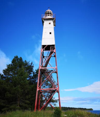
Samboy Light
Samboy (Mys Cheynavolok) Light, Podporozhsky District, 2010
ex-Panoramio photo copyright Sergey Gruzdev; used by permission

Leningrad Oblast Lighthouses

Podporozhsky District (Southwest Shore) Lighthouses
* Samboy (Sambo, Mys Cheynavolok)
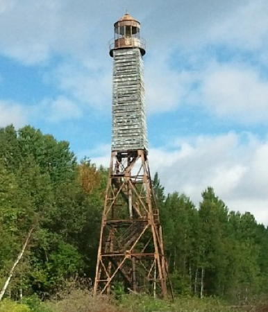
1926. Inactive. 23 m (75 ft) square steel skeletal tower, upper portion enclosed by a slatted daymark, with lantern and gallery. Skeletal tower painted red, lantern and daymark painted white. Sergey Gruzdev's photo is above, a 2019 photo is available,Alexey Yurikov has a 2017 photo, Aleks Hayell has a 2018 view, and Google has an indistinct satellite view. Endangered. Located on Cape Cheynavolok, a prominent cape on the southwest portion of the lake, about 16 km (10 mi) northeast of Vozhesenye. Site open, tower closed. ARLHS ERU-200.
Kulikovskiy
Date unknown. Inactive. 20 m (66 ft) tower. No photo available and trees hide the lighthouse in Google's satellite view. Located at the tip of a promontory on the north side of the exit from the lake to the Svir River and the White Sea-Baltic Sea Canal. Site status unknown. ARLHS ERU-188.
* Voznesenye Range Front
Date unknown. Active; focal plane about 11 m (36 ft); continuous red light. 10 m (33 ft) square skeletal tower carrying two slatted daymarks painted white with a red vertical stripe. No photo available but Google has a satellite view. The range guides vessels entering the Svir River from the lake. Located on the east side of the river entrance in Voznesenye. Site open, tower closed.
* Voznesenye Range Rear
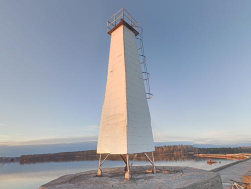
Date unknown. Active; focal plane about 15 m (49 ft); continuous green light. 14 m (46 ft) square skeletal tower carrying two slatted daymarks painted white with a red vertical stripe. Google has the street view seen at right and a satellite view. The range guides vessels entering the Svir River from the lake. Located on the east side of the river entrance in Voznesenye. Site open, tower closed.

Range Rear Light, Voznesenye, June 2013
Google Maps street view

Vologda Oblast Lighthouses

Vytegorsky District (South Shore) Lighthouses
Petropavlovskiy
Date unknown. Inactive. 16 m (52 ft) square skeletal tower with lantern and gallery. The lighthouse is covered with a dilapidated slatted wood daymark, originally painted white. Google has a satellite view. Sibling of the Andomskiy lighthouse seen at right. Endangered. Located on a prominent cape north of Golyashi, about halfway between the Vytegra and Svir River entrances. Site status unknown. ARLHS ERU-197.
Vytegra River Entrance
Date unknown. Active; focal plane about 17 m (56 ft); two white flashes every 4.4 s. Approx. 14 m (46 ft) round fiberglass (?) tower with gallery, raised on a tripod skeletal base. Lighthouse painted with black and white skeletal bands. Alexandra Levina has a distant view from the lake and Google has an indistinct satellite view. This lighthouse marks the entrance to the Volga-Baltic Sea Waterway at the mouth of the Vytegra River. Located near the base of the breakwater on the north side of the entrance to the Vytegra from the lake. Site status unknown.
Vytegra Entrance Range Front
Date unknown. Active; focal plane about 12 m (39 ft); continuous white light. Approx. 12 m (39 ft) skeletal tower. No photo available but Bing has an indistinct satellite view. Located on the south side of an island in the river entrance. Accessible only by boat. Site status unknown.
Vytegra Entrance Range Rear
Date unknown. Active; focal plane about 20 m (66 ft); flashing white light. Approx. 20 m (66 ft) skeletal tower. No photo available but Google has an indistinct satellite view. Located on the south side of the river about 600 m (3/8 mi) east southeast of the front light. Accessible only by boat. Site status unknown.
Andomskiy (?)
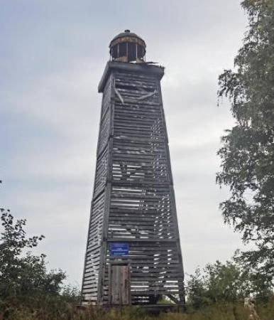
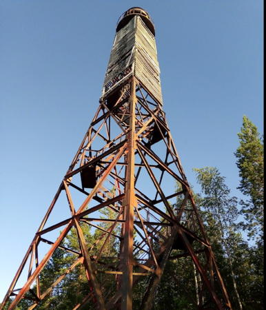
Date unknown. Inactive for many years and possibly collapsed; focal plane 45 m (148 ft). 16 m (52 ft) square skeletal tower with lantern and gallery. The lighthouse is covered with a dilapidated slatted wood daymark, originally painted white. The lantern fell in 2012. A photo is at right. Endangered. Abandoned and deteriorating rapidly in the Arctic climate, this lighthouse may have collapsed; it is not seen in Google's satellite view. Its purpose was probably to guide vessels toward the start of the Volga-Baltic Waterway, 20 km (13 mi) to the south. Located on a prominent cape at the southeast corner of the lake near Klimovskaya. Site open, tower open but unsafe. ARLHS ERU-178.
Andomskiy Light
Andomskiy Light, Vytegorsky District
unattributed photo from Geocaching.su

Republic of Karelia Lighthouses

Pudozhsky District (East Shore) Lighthouses
* Besov Nos
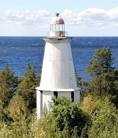
Date unknown. Inactive. 16 m (52 ft) round wood tower with lantern and gallery, mounted on a 2-story octagonal wood base. Lighthouse painted white with dark trim. Michael Skolsky's photo is at right, a closeup photo and another photo are available, and Bing has a satellite view. The lighthouse was previously endangered; Evgeny Shevaturin's 2017 photo showed it to be in very poor condition. Since then it has been at least partially repaired and repainted. The site is famous for its Stone Age petroglyphs. Besov Nos is "Devil's Nose" in Russian. Located on a prominent cape on the eastern shore of the lake about 40 km (25 mi) west of Pudozh. Site open, tower closed. Site manager: unknown. ARLHS ERU-181.
Mikhaylovets
Date unknown. Inactive; focal plane 28 m (92 ft). 19 m (62 ft) square skeletal tower with lantern and gallery. Petr Vorobyev has a distant view from the lake and Google has an indistinct satellite view. Endangered. Located on a small island about 4 km (2.5 mi) north northwest of Besov Nos. Accessible only by boat. Site status unknown. ARLHS ERU-193.
Vodla River Range Front
Date unknown. Active; focal plane about 14 m (46 ft); continuous red light. Approx. 11 m (36 ft) square skeletal tower carrying a slatted white daymark. Andrey Evstyunichev has a street view of the range lights and Google has a satellite view. Located on the east side of the river entrance. Site open, tower closed.
Vodla River Range Rear
Date unknown. Active; focal plane about 20 m (66 ft); continuous green light. Approx. 15 m (49 ft) square skeletal tower carrying a slatted white daymark. Andrey Evstyunichev has a street view of the range lights and Google has a satellite view. Located about 150 m (500 ft) northeast of the front light. Site open, tower closed.
Sosnovo Shalskiy
Date unknown. Inactive; focal plane 24 m (79 ft). 18 m (59 ft) square skeletal tower with lantern and gallery. No photo available but Google has an indistinct satellite view. Endangered. Located on a small island about 2.5 km (1.5 mi) west of the mouth of the Vodla River at Ust'e. Accessible only by boat. Site status unknown. ARLHS ERU-203.

Besov Nos Light, Pudozhsky District, July 2021
Google Maps photo by Michael Skolsky
Vasilisin
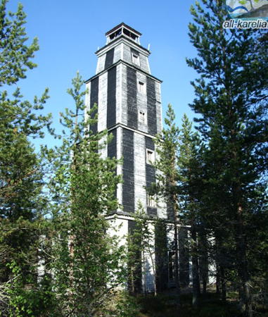
Date unknown. Inactive; focal plane 33 m (108 ft). 24 m (79 ft) four-stage square wood tower with lantern and gallery, painted with black and white vertical stripes. Victoria Butskikh's closeup photo is at right, and Bing' has a very distant satellite view. This impressively large and historic lighthouse is clearly endangered. Located on the island of Vasilisin, about 15 km (9 mi) west of Ust'e. Accessible only by boat. Site open, tower closed. ARLHS ERU-207.
Kuzovets
Date unknown. Inactive; focal plane 24 m (79 ft). 21 m (69 ft) square skeletal tower, lower portion pyramidal, with lantern and gallery. Tower and lantern painted red. A view from the lake is available and Bing has a satellite view. Endangered. This lighthouse marked the east side of the entrance to Zaonezhskiy Bay, the northern extension of Lake Onega. Located on an islet off the eastern lakeshore near Lukostrov. Accessible only by boat. Site status unknown. ARLHS ERU-189.

Segezhsky District (Lake Vygozero) Lighthouses
Lake Vygozero is located about halfway between Lake Onega and the White Sea. The White Sea-Baltic Sea Canal passes lengthwise through the lake, which is strewn with islands and shoals. The Canal follows the Vyg River from Vygozero northward to the White Sea. Note: the lake really should be called Lake Vyg in English, since ozero is the Russian word for "lake."

Ostrov Bom
Date unknown. Inactive. Approx. 23 m (75 ft) square skeletal tower, lower portion pyramidal, with lantern and gallery. Lighthouse painted black. Google has an indistinct satellite view. Endangered. Located on a small island in the center of the northern part of the lake. Accessible only by boat. Site open, tower closed.
Ostrov Godorovoy
Date unknown. Inactive. Approx. 23 m (75 ft) square skeletal tower, lower portion pyramidal, with lantern and gallery. A photo and a second photo are available and Bing has a satellite view. A twin of the Ostrov Bom lighthouse. Endangered. Located on a tiny island in the center of the lake, about 10 km (6 mi) south of Ostrov Bom. Accessible only by boat. Site open, tower closed.
Ostrov Kainskiy
Date unknown. Active; focal plane perhaps 20 m (66 ft); light flashing red in groups of two, period unknown. Skeletal tower, height unknown, carrying a triangular slatted daymark painted white with a red or black vertical stripe. No photo available but Bing has a satellite view. This appears to be a leading light for southbound vessels. Located at the northern tip of a narrow island on the east side of the shipping channel in the southern half of the lake. Accessible only by boat. Site open, tower closed.

Vasilisin Light, Pudozhsky District
all-Karelia.ru photo by Victoria Butskikh

Medvezhyegorsky District: Povenetskiy Bay and Zaonezhskiy Bay Lighthouses
Povenetskiy Bay and Zaonezhskiy Bay together form a long, curved arm of Lake Onega extending northward to the town of Medvezh'egorsk. The upper portion of the arm, above the Krivonogovskaya peninsula, is called Povenetskiy Bay, and the lower section, connecting to the main part of Lake Onega, is Zaonezhskiy Bay. The White Sea-Baltic Sea Canal (BBK) enters Povenetskiy Bay at Povonets (Povenec) and follows the two bays southward into Lake Onega proper. The listing here is from north to south along the bays.
* Povenets Breakwater (Povenetskiy)
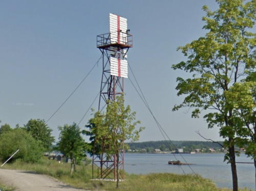
Date unknown. Active; focal plane about 17 m (56 ft); white flash every 3.1 s. Approx. 12 m (39 ft) square skeletal tower with gallery, covered with white panels as a daymark. Lightphotos.net has a closeup photo, Petr Vorobyev has the photo at right and a distant street view, and Google has a satellite view. Located at the end of a long, curved breakwater protecting the entrance to the White Sea-Baltic Sea Canal from Lake Onega at Povonets; Lightphotos.net has a photo that shows the canal entrance in the background. Site open, tower closed.
Ostrov Bychok
Date unknown. Active; focal plane 24 m (79 ft); white flash every 3 s. 24 m (79 ft) square skeletal tower with lantern and gallery, painted red; lantern painted white with a red roof. The tower carries a slatted daymark painted with red and white horizontal bands. Google has an indistinct satellite view. Endangered. Bychok means "bullhead" in Russian. Located on a small island (marking the end of a long reef) about 7 km (4.5 mi) southeast of Povenets. Accessible only by boat. Site status unknown. ARLHS ERU-183.
Azshepskiy (Shun'ga)
Date unknown. Inactive; focal plane 22 m (72 ft). 19 m (62 ft) square steel skeletal tower with lantern and gallery. The lighthouse appeared rusted and abandoned in a closeup photo (no longer online). Google has an indistinct satellite view. Endangered. Located on a small island off the south side of Povenetskiy Bay near Kudnavolok. Accessible only by boat. Site open, tower closed. ARLHS ERU-179.

Breakwater Light, Povonets, August 2018
Google Maps photo by Petr Vorobyev
Saloostrovskiy (Salostrov)
Date unknown. Active(?); focal plane 28 m (92 ft); two white flashes every 5 s. 22 m (72 ft) square steel skeletal tower with lantern and gallery. The upper half of the lighthouse is covered by a dilapidated slatted daymark. Amateur radio operator RA3NQ has a view of the lighthouse and Google has a satellite view. Located at the tip of an island marking the end of a long shoal extending halfway across Povenetskiy Bay from the south side near Krivonogovskaya. Accessible only by boat. Site status unknown. ARLHS ERU-199.
Megostrov (Megoostrovskiy, Ostrov Meg) Range Front
Date unknown. Active; focal plane 35 m (115 ft); continuous white light. 15 m (49 ft) skeletal mast carrying a slatted daymark. Google has a very distant satellite view. Lighthouse painted white with a black vertical stripe on the range line. The range guides northbound vessels on a long reach up Povenetskiy Bay. Located at the southern tip of Ostrov Meg, a triangular island in the center of Povenetskiy Bay. Accessible only by boat. Site open, tower closed.
Megostrov (Megoostrovskiy, Ostrov Meg) Range Rear
Date unknown. Active; focal plane 44 m (144 ft); white flash every 3.1 s. 15 m (49 ft) skeletal mast carrying a lantern and a slatted daymark. Lighthouse painted white with a black vertical stripe on the range line; lantern dome also painted black. Amateur radio operator RV3NX has a photo and Geocaching.su has a closeup but Google has only a very distant satellite view. The range guides vessels northbound on a long reach through Povenetskiy Bay. Located about 100 m (330 ft) north of the front light. Accessible only by boat. Site open, tower closed. ARLHS ERU-192.
Pesotskiy (Ostrov Khed)
Date unknown. Inactive; focal plane 24 m (79 ft). 22 m (72 ft) square skeletal tower, lower portion pyramidal, with a round lantern and gallery. Lighthouse painted red with white slatted daymarks near the top. Lightphotos.net has Nikita Groshkov's closeup photo and distant view, and Bing has an indistinct satellite view. Endangered. This light was replaced by a buoy. Located on an island on a long shoal in the center of the bay, about 8 km (5 mi) northeast of Afonino. Accessible only by boat. Site open, tower closed. ARLHS ERU-196.
Tambits Nos
Date unknown. Inactive; focal plane 25 m (82 ft). 23 m (75 ft) square skeletal tower, lower portion pyramidal, with lantern and gallery. Lighthouse painted red with dilapidated white slatted daymarks near the top. A photo by Alex Kondratyev is at right and Bing has a distant satellite view. Endangered. Located near Tambitsiy on a peninsula at the "bend of the elbow," where the direction of the fjord changes by 90°, from northeast to northwest. Site open, tower closed. ARLHS ERU-206.
Tambits Nos Light
Tambits Nos Light, Medvezhyegorsky District, August 2010
ex-Panoramio Creative Commons photo by Alex Kondratyev

Medvezhyegorsky District: North Shore (Kizhi Area) Lighthouses
Kizhi is a small island on the north coast of Lake Onega, famous as the location of two 18th century Orthodox churches.

Leynavolok
Date unknown. Inactive. No information and no photo are available about this lighthouse; Google has a distant satellite view. Located at the tip of a promontory at the west side of the entrance to Zaonezhskiy Bay and the east side of the entrance to Velikaya Bay. Accessible only by boat. Site status unknown.
Ostrov Voroniy (Velikaya Bay)
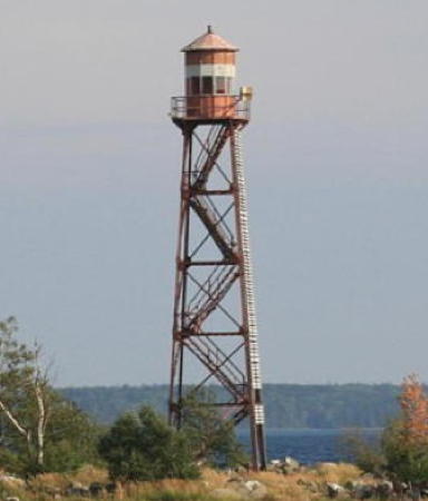
Date unknown. Inactive. Approx. 20 m (66 ft) square skeletal tower with lantern and gallery. Lighthouse painted red with a narrow white band around the lantern. A photo is at right but the tower escapes notice in Google's satellite view of the island. Endangered. Located on an island in Velikaya Bay. Accessible only by boat. Site open, tower closed.
Klimenitskiy
Date unknown. Inactive; focal plane 34 m (112 ft). 32 m (105 ft) square steel skeletal tower with lantern and gallery, painted red. One face of the tower carries a slatted daymark painted white with a black vertical stripe. No photo available but Google has an indistinct satellite view. Endangered. Located on a small island off the southern tip of Ostrov Bolshoy Klimenitskiy. Accessible only by boat. Site status unknown. ARLHS ERU-187.
Garnitskiy
Date unknown. Active; focal plane 17 m (56 ft); flash every 4 s, white or red depending on direction. 16 m (52 ft) square steel skeletal tower with lantern and gallery, painted red. One face of the tower carries a slatted daymark painted white with a black vertical stripe. A nice view from the lake is available, Wikimedia has Svetlana Makarova's panoramic view, Irina Pototskaya has a photo, and Google has an indistinct satellite view. The lighthouse is a twin of the Ostrov Voroniy Light seen at right. Located on a small island in the northernmost part of the lake, off the west coast of Ostrov Bolshoy Klimenitskiy. Accessible only by boat, but there's a good view from tour boats bound for Kizhi. Site open, tower closed. ARLHS ERU-184.

Kondopozhsky District Lighthouses
Sosnovo Unitskiy
Date unknown. Active(?); focal plane 24 m (79 ft). 22 m (72 ft) square steel skeletal tower with lantern and gallery, painted red. Andrey Stvolinsky has a photo and Google has an indistinct satellite view. This lighthouse is on an island in the Unitskiy Gulf in the northern part of the lake, near the abandoned village of Pegrema, which is famous for its 15th century chapel. Accessible only by boat. Site status unknown. ARLHS ERU-204.
Ostrov Voroniy Light
Ostrov Voroniy Light, Medvezhyegorsky District, August 2006
ex-Panoramio Creative Commons photo by Vladnes
Syar Nos (lantern)
Date unknown. Inactive. Round lantern, painted white, with a red dome. No photo available and the small lantern is not seen in Google's satellite view of the area. Apparently the abandoned lighthouse was dismantled by thieves who left the lantern on the beach. Located on a promontory of the mainland north of the Berezovetskiy lighthouse. Site open.
Berezovetskiy
Date unknown. Inactive; focal plane 25 m (82 ft). 22 m (72 ft) square skeletal tower with lantern and gallery. The lower portion of the tower is pyramidal and upper portion is cylindrical. No photo available but Google has a satellite view. Endangered. This tall lighthouse is located on Ostrov Berezovye, a small island near the northwestern corner of the lake, marking the entrance to the Kondopozhskaya fjord leading to Kondopoga. ARLHS ERU-180.

Prionezhsky District (Petrozavodsk Area) Lighthouses
Ostrov Monak
Date unknown. Inactive; focal plane 19 m (62 ft). 17 m (56 ft) square cylindrical skeletal tower with gallery. No photo available but Bing has a distant satellite view. Located on a small island about 15 km (9 mi) northeast of the Ivanovskiy lighthouse. Accessible only by boat. Site open, tower closed. ARLHS ERU-194.
Ivanovskiy (Ivanono)
Date unknown. Inactive; focal plane 25 m (82 ft). 27 m (89 ft) square steel skeletal tower with lantern and gallery, lower portion pyramidal and upper portion cylindrical. Sergey Fendrikov has a photo, Alexander Egorov has a photo, and Google has a distant satellite view. Sibling of the Ostrov Bom lighthouse in Lake Vygozero (see above). This lighthouse marks the north side of the entrance to the bay of Petrozavodsk. Endangered. Located on a small island about 18 km (11 mi) east southeast of the Petrozavodsk waterfront. Accessible only by boat, but there are good views from hydrofoil tours leaving Petrozavodsk for the historic village of Kizhi. Site and tower closed. ARLHS ERU-185.
Shokshinskiy (Shoksha)
Date unknown. Inactive; focal plane 26 m (85 ft). 25 m (85 ft) octagonal skeletal tower with lantern and gallery. The upper half of the tower is surrounded by a slatted daymark. A 2021 closeup photo is available and Bing has a satellite view. Endangered. Located at the northern tip of an island at the entrance to the bay of Kvartsitnyy. Site status unknown. ARLHS ERU-202.
Brusno
1887 (?). Inactive; focal plane 23 m (85 ft). 22 m (72 ft) square pyramidal skeletal tower with lantern and gallery; the upper portion of the tower is enclosed. Lantern and upper portion of the tower painted white; the remainder of the tower is gray metal. Amateur radio operator RN1NU has provided a photo and Bing has a satellite view. Located on the east side of an island off the west shore of the lake south of Petrozavodsk. Accessible only by boat. Site status and site manager unknown. ARLHS ERU-182.
Sukhonosskiy (Sukhoy Nos)
Date unknown. Inactive; focal plane 17 m (56 ft). 16 m (52 ft) square skeletal tower with gallery. The tower is covered with a slatted daymark painted white. A good 2008 photo is at right, a 2020 photo is available, and Bing has a satellite view. Located on Sukhoy Nos ("Dry Point"), a cape about 7 km (4 mi) east of Sheltozero. ARLHS ERU-205.
Sukhonosskiy Light
Sukhonosskiy Light, Prionezhsky District, September 2006
ex-Panoramio photo copyright phumala; used by permission

Information available on lost lighthouses:

Notable faux lighthouses:

Adjoining pages: North: Southern White Sea | South: Lake Ladoga

Return to the Lighthouse Directory index | Ratings key

Posted May 22, 2005. Checked and revised August 13, 2023. Lighthouses: 39. Site copyright 2023 Russ Rowlett and the University of North Carolina at Chapel Hill.