Lighthouses of Sénégal

The Republic of Sénégal is the country in the westernmost bulge of the African continent, south of Mauritania and north of Guinea. Portuguese explorers were the first Europeans to reach this area, and for several centuries Portugal, Holland, Britain and France struggled to control the region. France prevailed in 1677 and eventually made Dakar the largest city, a major port, and the administrative center of French West Africa. Sénégal has been independent since 1960.

The Gambia is an independent nation surrounded by the southern part of Sénégal.

French is the official language of government and trade in Sénégal, although the West African language Wolof and Arabic are commonly spoken. The French word for a lighthouse is phare, although a smaller light or harbor light is called a feu (literally "fire," but here meaning "light") or a balise (beacon). In French île is an island, cap is a cape, pointe is a promontory or point of land, roche is a rock, récife is a reef, baie is a bay, estuaire is an estuary or inlet, détroit is a strait, rivière is a river, and havre is a harbor.

Aids to navigation in Sénégal are maintained by the Subdivision des Phares et Balises within the Port Autonome de Dakar.

ARLHS numbers are from the ARLHS World List of Lights. Admiralty numbers are from volume D of the Admiralty List of Lights & Fog Signals. U.S. NGA List numbers are from Publication 113.

General Sources
Phares d'Afrique
Photos posted by Alain Guyomard and Robert Carceller as part of their Phares du Monde web site.
Online List of Lights - Sénégal
Photos by various photographers posted by Alexander Trabas. Most of the photos for Sénégal are by Erich Hartmann or Eckhard Meyer.
World of Lighthouses - Senegal
Photos by various photographers available from Lightphotos.net.
Lighthouses in Senegal
Photos by various photographers available from Wikimedia.
Afrikanische Leuchttürme auf historischen Postkarten
Postcards from the collection of Klaus Huelse.
Navionics Charts
Navingation chart for Sénégal.

Phare des Mamelles
Les Mamelles Light, Dakar, January 2008
Wikimedia public domain photo by Ji-Elle

Ziguinchor Region (Casamance) Lighthouse
Known traditionally as Casamance, the Ziguinchor region is the strip of southernmost Sénégal wedged between The Gambia and Guinea-Bissau. This area was originally colonized by Portugal; it was transferred to French Sénégal in 1888.

#Pointe de Diogué (Djogué) (?)
Date unknown. Inactive at least since 2013 (possibly much longer). 21 m (69 ft) "pylon," actually a skeletal tower, mounted on a triangular platform supported by piles. No photo available. Google's satellite view shows the tower but it may be fallen in the water. (Note: the port authority's web site formerly lised a light at Djogué; it's not known if this was an obsolete mention or if a new light had been established.) Diogué is a fishing port on the north side of the mouth of the Casamance River. Located offshore in the north side of the Casamance River just south of Diogué. Accessible only by boat. Site open, tower closed. ex-Admiralty D3038; ex-NGA 24476.

Southern Thiès Region Lighthouses
* Joal
Date unknown. Active; focal plane 14 m (46 ft); white light occulting once every 4 s. 13 m (43 ft) slender square skeletal tower painted with red and white horizontal bands. A square 1-story equipment building stands beside the tower. Google has a street view and an indistinct satellite view. Located on the Route M'bour-Joal opposite the municipal stadium in Joal-Fadiouth, a fishing town about 40 km (25 mi) southeast of M'bour. Site open, tower closed. Admiralty D3019; NGA 24444.
* M'bour
Date unknown (about 2002). Active (privately maintained?); focal plane about 13 m (43 ft); light pattern unknown. Approx. 11 m (36 ft) square cylindrical concrete skeletal tower, enclosed in recent years. The tower is painted white; the name of the port is on the side of the tower in black block letters. Google has a 2021 street view, Nicolas Renous has a closeup 2005 photo, a 2013 photo (last photo on the page) is available, and Google has a satellite view. M'bour is a city on the coast about 60 km (38 mi) southeast of Dakar. There is no natural protected harbor, so the fishermen of M'bour traditionally land their pirogues directly on the beach. According to one source (no longer online), the French city of Concarneau donated funds in 2001 to build a quay and a lighthouse. Located close to the beach in downtown M'bour, near where the fishermen sell their catch. Site open, tower closed. This light is not listed by the Admiralty or by NGA but the port authority formerly mentioned it.

Dakar Lighthouses
* Rufisque (4?)
Date unknown (station established 1879). Active; focal plane 12 m (39 ft); green light, 1 s on, 1 s off. 12 m (39 ft) square white concrete tower. Amady Sy has a 2018 photo, Nelson Jaramillo has a 2016 distant view, and Google has a street view and a satellite view. The previous light is described by NGA as a "black metal framework" tower, and a small photo (halfway down the page) of that tower is available. The original light had a focal plane of 16 m (52 ft); it was replaced in 1913 by a short skeletal tower atop a rectangular multistory building. Located on a promontory in Rufisque, a city about 20 km (13 mi) west of Dakar, on the opposite side of the Baie de Gorée. Site open, tower closed. ARLHS SEN-008; Admiralty D3018; NGA 24440.
* Gorée (2?)
Date unknown (station established 1843). Active; focal plane 21 m (69 ft); white or red light, depending on direction, occulting twice every 6 s. 4 m (13 ft) square 1-story concrete equipment room; the light is shown from a small metal tower atop the building. Metal tower painted red, the rest white. Wyndham Whynot contributed the photo at right and Google has a distant satellite view of the area. The Île de Gorée is an island about 4 km (2.5 mi) east of the Dakar waterfront. Settled by Portuguese traders as early as 1444, occupied by the Dutch in 1588, and taken by the French in 1677, it was the first European toehold in West Africa. It is widely regarded as having been a regional center for the slave trade, although historians have shown that very few slaves actually passed through the island. Now a historic site with several museums, it is accessible by frequent passenger ferries from Dakar. The lighthouse is located at the south end of the island in front of the Castel de Gorée. The original light was shown from within the fort. Site open, tower closed. ARLHS SEN-006; Admiralty D3010; NGA 24404.

Gorée Light, Dakar, June 2008
photo copyright Wyndham Whynot; used by permission
* Grande Mosque (Dakar Central Mosque)
1964. Active (?); focal plane 88 m (289 ft); flashing white light. Approx. 80 m (262 ft) square green and white tower. Mustafa Durmaz has a photo and Google has a satellite view. This light would have limited navigational value; the Admiralty does not list it but it is charted by Navionics. Located in the center of downtown Dakar. Site open, tower closed. NGA 24420.
Dakar Entrée Feu Vert (North Jetty) (2)
Date unknown. Active; focal plane 9 m (30 ft); green light, 2 s on, 2 s off. 9 m (30 ft) round cylindrical tower, painted white with a green top. Lightphotos.net has a 2018 photo of the new light, Trabas has Hartmann's photo, and Google has a satellite view. Located at the south end of the north breakwater enclosing Dakar harbor. Site and tower closed, but there's a good view from ferries to Gorée. ARLHS SEN-005; Admiralty D3012; NGA 24408.
Dakar Entrée Feu Rouge (South Jetty)
Date unknown. Active; focal plane 11 m (36 ft); red light occulting four times every 12 s. 9 m (30 ft) round cylindrical tower, painted white with a red top. Lantern removed. Lightphotos.net has a 2018 photo of the new light, Trabas has Hartmann's photo, a 2012 photo of the older light is available, and Google has a satellite view. Located at the end of the main jetty on the south side of the entrance to Dakar harbor. Site and tower closed, but there's a good view from ferries to Gorée. ARLHS SEN-007; Admiralty D3013; NGA 24412.
* Cap Manuel (2)
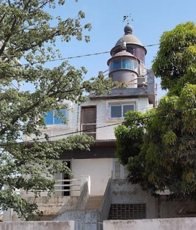
Date unknown (station established 1869). Active; focal plane 50 m (164 ft); red flash every 5 s; also at focal plane 48 m (157 ft) a continuous red or white light, depending on direction (this light has been dropped by the Admiralty but is still listed by NGA). Fresnel lens in use. This unusual lighthouse has a rectangular cylindrical tower with two lanterns, one higher than the other, each with a gallery, rising from a 2-story keeper's house. Building painted white, lanterns and galleries red. A photo by Dorothy Voorhees is at right, Mark Moxon has posted a photo, Lightphotos.net has a closeup photo, Trabas has Meyer's photo, and Google has a street view and a satellite view. Huelse has a historic postcard view of the original lighthouse. The Presqu'île de Cap Vert peninsula is shaped roughly like a boot, with the Pointe des Almadies at the heel; this lighthouse is at the toe, about 7 km (4 mi) south of the city, marking the entrance to the sheltered waters of Dakar harbor. Site open, tower closed. Upper light: ARLHS SEN-001; Admiralty D3008; NGA 24396. Lower light: ARLHS SEN-002; ex-Admiralty D3008.2; NGA 24400.
Cap Manuel Light
Cap Manuel Light, Dakar, December 2008
Flickr Creative Commons photo by Dorothy Voorhees
**** Les Mamelles (Cap Vert)
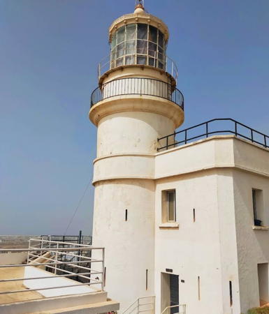
1864. Active; focal plane 120 m (394 ft); white flash every 5 s. 16 m (52 ft) cylindrical masonry tower with lantern and gallery, attached to the front of a 2-story keeper's house. 2nd order Fresnel lens in use. Entire structure painted white. A photo is at the top of this page, Thom Haslam has a good 2006 photo, Isidore Boullu has a good closeup, Trabas has Hartmann's photo, the French Wikipedia has an article on the history of the light station, Huelse has a historic postcard view, Dmitriy Orlovskiy has a street view, and Google has a satellite view. This is one of the world's great lighthouses, guiding ships around the western tip of Africa. Its light has a range listed at 57 km (almost 36 mi). Sadly, poor maintenance of the aging equipment hinders the operation of the light. A report at the end of 2007 showed an erosion rate of 2 m (6.5 ft) per year. Located on one of two rounded hills called Les Mamelles (The Breasts), about 7.5 km (4.5 mi) southeast of the Pointe des Almadies and 9 km (5.5 mi) northwest of Dakar. Site open, tower open to guided tours. . ARLHS SEN-003; Admiralty D3004; NGA 24392.
Chaussée des Almadies (N'Gor)
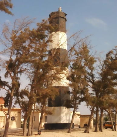
Date unknown. Active; focal plane 14 m (46 ft); two white flashes every 6 s. 17 m (56 ft) masonry tower with lantern and gallery, painted white with narrow black horizontal bands. Trabas has Hartmann's photo (also seen at right), Wikimedia has a photo, Thom Haslam has a sunset view, and Google has a satellite view. This is the westernmost lighthouse of Africa, standing in longitude 17° 32.6' W. Located on a reef just off the Pointe des Almadies, which is the ultimate tip of Cap Vert, about 6 km (4 mi) west of N'Gor and 13 km (8 mi) northwest of Dakar. Accessible only by boat. Site and tower closed. ARLHS SEN-004; Admiralty D3002; NGA 24388.

Saint-Louis du Sénégal Lighthouses
* Saint-Louis Gandiole
1843. Active (?); focal plane 26 m (85 ft); white light occulting three times every 12 s. 26 m (85 ft) octagonal cylindrical masonry tower, painted with black and white horizontal bands. Lantern removed. Philippe Boissel has a 2008 photo, Sara Hollerich has a photo, Giuseppe Piscitello has a closeup, a 2020 photo is available, and Google has a satellite view. Saint-Louis du Sénégal is a historic city built on islands in the lower Sénégal River, near the northern border of the country. The river flows southward from the city, behind a barrier beach, for about 50 km (30 mi) before entering the sea. The lighthouse is located on the mainland beach opposite the mouth of the river. Site open, tower closed. ARLHS SEN-009; Admiralty D2998; NGA 24384.

Chausée des Almadies Light, Dakar
photo copyright Erich Hartmann
#Saint-Louis (Guet N'Dar) (?)
Date unknown. Evidently removed but still listed with focal plane 15 m (49 ft); two white flashes every 6 s. This was a 14 m (46 ft) square cylindrical concrete skeletal tower, unpainted. Google has a 2015 street view. The tower is not seen in Google's current satellite view and its 2021 street view shows construction equipment on the site. Located on the beach of the barrier island at Saint-Louis. Site open. Admiralty D2996; NGA 24380.

Information available on lost lighthouses:

Notable faux lighthouses:

Adjoining pages: North: Mauritania | South: Guinea-Bissau | West: Cape Verde | Enclave: The Gambia

Return to the Lighthouse Directory index | Ratings key

Posted August 26, 2005. Checked and revised April 1, 2023. Lighthouses: 16. Site copyright 2023 Russ Rowlett and the University of North Carolina at Chapel Hill.