Lighthouses of North Central Vietnam

The Socialist Republic of Vietnam occupies the east coast of Mainland Southeast Asia. After being independent for many centuries Vietnam was colonized by France as part of French Indochina from the mid 1800s until 1941, when the country was invaded and conquered by Japan. After the end of World War II in 1945 French attempts to re-establish control triggered 30 years of warfare. In 1954 an armistice agreement provided for the French withdrawal but divided the country into northern and southern halves. The Vietnam War, a complex struggle between the two Vietnamese governments, was already underway in the late 1950s and escalated with U.S. intervention beginning in 1964. U.S. troops were withdrawn in 1973 and two more years of war led to the reunifucation of the country in 1975.

Vietnam is long and narrow, with a coastline measuring some 3000 km (1875 mi) in length. The northern third of the coast faces the Gulf of Tonkin (Vịnh Bắc Bộ, "Northern Bay" in Vietnamese) and the rest faces east and southeast on the open waters of the South China Sea, known as Biển Đông, "East Sea" in Vietnamese.

Vietnam is divided into 58 provinces and five province-level municipalities. This page includes the lighthouses of the northern half of the central coast, facing east on the South China Sea, from Thanh Hóa Province through Quảng Ngãi Province. From 1945 to 1975 the first four provinces covered, Thanh Hóa through Quảng Bình, were part of of "North Vietnam" (the Democratic Republic of Vietnam), while the remaining provinces covered, Quảng Trị through Quảng Ngãi, were in "South Vietnam" (the Republic of Vietnam).

Fortunately the lighthouses of Vietnam were not usually seen as targets during the Vietnam War and most of them survived the fighting without major damage. A few of the historic French lighthouses have been replaced but most remain in service and are regarded as historic monuments. In general Vietnamese lighthouses have resident keepers.

The Vietnamese words for a lighthouse are hải đăng or đèn biển ("sea light"). Dao or hòn is an island, quần đảo is an archipelago, bãi cạn is a shoal, mũi is a cape, sông is a river, cửa ("door") is the mouth of a a river, vịnh is a bay, and hải cảng is a harbor.

Aids to navigation in Vietnam are maintained by two Maritime Safety Companies, Vietnam Maritime Safety - North (VMS-North) maintaining lights in the northern half of the country and Southern Vietnam Maritime Safety (VMS-South) maintaining the lights of the southern half. All the lights on this page are maintained by VMS-North.

ARLHS numbers are from the ARLHS World List of Lights. Admiralty numbers are from volume F of the Admiralty List of Lights & Fog Signals. U.S. NGA List numbers are from Publication 112.

General Sources
Vietnam Northern Marine Safety - Beacon System
An interactive map of lighthouse locations, linking to pages on the individual light stations.
World of Lighthouses - Vietnam
Photos by various photographers available from Lightphotos.net.
Online List of Lights - Vietnam - Gulf Of Tonkin and South China Sea
Photos by various photographers posted by Alexander Trabas.
Leuchttürme Asiens auf historischen Postkarten
Historic postcard images posted by Klaus Huelse.
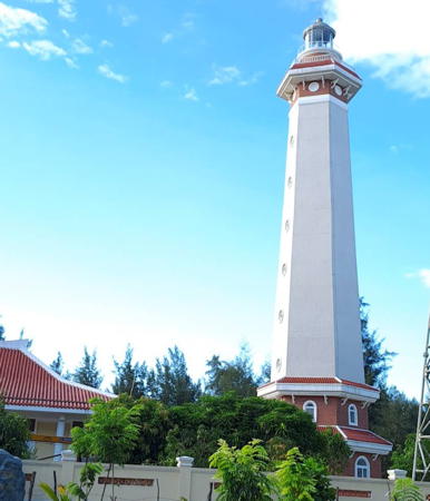

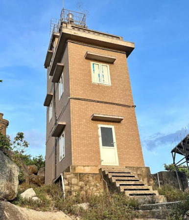
Thuận An Light, Thuận An, June 2024
Google Maps photo by Nguyễn Thị Trúc Hạ
Thanh Hóa Province Lighthouses
* Lạch Trào (Lạch Chào)
1965. Active; focal plane 27 m (89 ft); two white flashes every 10 s. 22 m (72 ft) octagonal concrete tower with gallery. Lighthouse painted gray, lantern yellow. 1-story keeper's houses, painted yellow. Kien Kythuat has a 2023 photo and Google has a satellite view. Lạch Trào is the seaport associated with Thanh Hóa, located about 13 km (8 mi) east of the city. Located on the north side of the estuary entrance. Site open, tower closed. Admiralty F3227.
Hòn Mê (2?)
1977. Active; focal plane 154 m (505 ft); three white flashes, in a 2+1 pattern, every 15 s. 18.5 m (61 ft) round concrete tower with lantern and gallery, rising from a 1-story concrete keeper's house. Entire lighthouse painted white. Hiếu Trung has a closeup 2023 photo and Google has a satellite view. Hòn Mê is an island about 15 km (9 mi) offshore and 25 km (15 mi) southeast of Tĩnh Gia. Located on the highest point of the island. Accessible only by boat. Site status unknown. ARLHS VIE-026; Admiralty F3225; NGA 20274.
Biển Sơn (3)
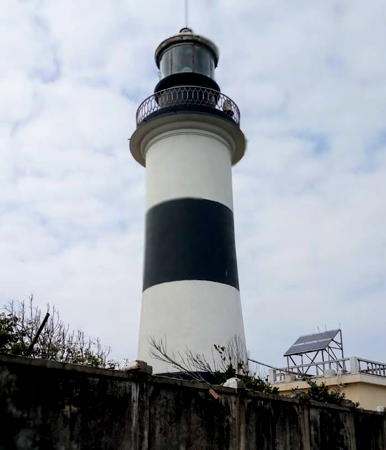
Date unknown (station established 1904). Active; focal plane 34 m (112 ft); white flash every 5 s. 14 m (46 ft) round concrete tower with lantern and gallery, painted with black and white horizontal bands. Oden Kardakov's photo is at right, Trung Hoang has a closeup photo, Quân Sup Lê has a 2024 drone view, and Bing has a fuzzy satellite view. The 1962 lighthouse was an 11.5 m (38 ft) square skeletal tower mounted on a 1-story square concrete service building. Biển Sơn is an inhabited island just off the coast opposite Hòn Mê. A causeway connects the island to the mainland. Located on the eastern side of the island, which shelters a small harbor. Site status unknown. Admiralty F3224; NGA 20275.

Nghệ An Province (Vinh Area) Lighthouses
Hòn Mát (Mui Sot)
2004. Active; focal plane 202 m (663 ft); three white flashes, in a 2+1 pattern, every 10 s. 12.5 m (41 ft) round cylindrical concrete tower with lantern and gallery. Lighthouse painted yellow with white trim. 2-story keeper's house, also painted yellow with white trim. Trần Thị Thúy Hà has a photo and Google has a fuzzy satellite view. Apparently the lantern was added around 2018. This is the landfall light for the port of Vinh, the largest city of Vietnam's north central coast. Hòn Mát is an isolated high island about 20 km (13 mi) off the coast just north of Vinh. Located on the highest point of the island. Accessible only by boat. Site status unknown. Admiralty F3219.5; NGA 20276.1.

Biển Sơn Light, Thanh Hóa, December 2019
Google Maps photo by Oden Kardakov
Hòn Lò (Mui Rong, Cửa Lò)
Date unknown. Active; focal plane about 20 m (66 ft); white flash every 1.5 s. Approx. 20 m (66 ft) tower, upper half painted yellow and lower half black, mounted on a square pier. Quoc Nguyen has a very distant view, Mario Linke has a 2023 distant view, Thi Anh Tran also has a very distant view and Google has a satellite view. Located about 1.6 km (1 mi) off the protected harbor of Cửa Lò. Accessible only by boat. Site status unknown. Admiralty F3221.
Nghi Thiết
Date unknown. Active; focal plane about 22 m (72 ft); green light, pattern unknown. Approx. 20 m (66v ft) round concrete tower with gallery, upper half painted yellow and lower half black. Luu Van Danh has a 2022 photo, Dương Nguyễn has a photo and Google has a satellite view. Nguyễn Tâm's distant view also shows a much older beacon. Located on a pier on the northside of the entrance to Mui Rong. Accessible only by boat. Site status unknown. Admiralty F3221.1.
Cửa Hội (Vinh River) (2)
2015 (station established 1966). Active; focal plane 25 m (82 ft); three white flashes every 15 s. 25 m (82 ft) round cylindrical concrete tower with lantern and gallery, painted white with a narrow red vertical stripe. Anh Đức Trần has a 2016 photo, a foggy 2016 photo is available, Eden Arrizabalaga has a view from the river, and Google has a satellite view. The original light was a square skeletal tower. Located on the north side of the entrance to the Cửa Hội estuary about 12 km (7.5 mi) northeast of Vinh. Site status unknown. ARLHS VIE-043; Admiralty F3220; NGA 20276.

Hà Tĩnh Province Lighthouses
Cửa Sót (Mui Lo) (2)
Date unknown (station established 1969). Active; focal plane 90 m (295 ft); two white flashes every 6 s. 13 m (43 ft) square cylindrical concrete tower with three galleries, painted yellow with white trim. A 2023 photo is at right, Huy Hải has a photo, and Google has a distant satellite view. The present lighthouse replaced a short concrete beacon, seen to the left of the tower in the VMS-North photo and in a 2016 street view. Located on a forested headland on the south side of the entrance to the Cửa Sót estuary. Site status unknown. Admiralty F3219.3; NGA 20276.2.

Cửa Sót Light, Hà Tĩnh, August 2023
Google Maps photo by HUONGMIT
Cửa Nhượng
1967. Active; focal plane 35 m (115 ft); white flash every 6 s. 15 m (49 ft) round cylindrical concrete tower with gallery, adjacent to a 1-story keeper's house. The tower is painted with red and white horizontal bands. Cuong Tong's 2024 photo is at right, Hoang Nguyen Dang has a 2018 photo, Thoa Kim has a closeup, Huy Hải has a view from the sea, and Google has a satellite view. Located on the south side of the entrance to the Cửa Nhượng estuary about 25 km (15 mi) southeast of Hà Tĩnh city. Site status unknown. Admiralty F3219.2; NGA 20276.3.
Mũi Ròn
1999. Active; focal plane 205 m (673 ft); four white flashes every 20 s. 16 m (52 ft) round concrete tower with an expanded upper section. Lighthouse painted gray. 2-story keeper's house painted white. A 2019 photo is available, Phuc Tran has a second photo, and Google has a satellite view. Mũi Ròn is the cape at the end of a 5 km (3 mi) long peninsula that projects suddenly into the South China Sea, forming a significant hazard to navigation. Located on the headland at the tip of the peninsula. Site status unknown. Admiralty F3219.

Quảng Bình Province Lighthouses
* Cửa Gianh
1970. Active; focal plane 21 m (69 ft); three white flashes, in a 2+1 pattern, every 10 s. 20 m (66 ft) round concrete tower with gallery. Entire lighthouse painted light blue (formerly white). 2-story keeper's house. Ben Tong has a 2023 photo, Anh Trần has a 2021 drone view, a 2022 photo is available, and Google has a satellite view of the station. Located on the south side of the entrance to the Cửa Gianh estuary about 10 km (6 mi) north of Ly Hóa. Site appears open, tower closed. Admiralty F3218.5; NGA 20276.5.

Cửa Nhượng Light, Cẩm Lĩnh, August 2024
Google Maps photo by Cuong Tong
 
* Nhật Lệ (Dong Hoi)
1974. Active; focal plane 35 m (115 ft); three white flashes, in a 2+1 pattern, every 12 s. 20 m (66 ft) hexagonal concrete tower with lantern and two galleries. As of 2019 the upper section of the tower is gray and the lower half buff. Trabas has Eckhard Meyer's photo, Minh Hoá Hoàng has a 2018 photo, Tám Trần Đức has a 2019 photo, a 2007 photo is available, and Google has a 2023 street view and a satellite view. Located on the north side of the mouth of the Nhật Lệ River in Đồng Hới. Site open, tower status unknown. Admiralty F3218.3.

Quảng Trị Province Lighthouses
* Mũi Lay (Cap Lai)
1976. Active; focal plane 37.5 m (123 ft); two white flashes every 10 s. 12.5 m (41 ft) square cylindrical concrete tower rising from one end of a 1-story concrete keeper's house. Formerly painted white, as of 2020 the lighthouse is now painted dark gray. Viet Thanh Duong has a 2020 photo, Huong Nguyen has a photo, Bui Cong Truong has a 2021 photo, Thanh Long has a good 2017 photo, Lê Hoàng Đức has a 2022 drone view, and Google has a satellite view. Located on a prominant cape about 20 km (13 mi) north of Gio Linh. Site open, tower status unknown. ARLHS VIE-045; Admiralty F3218.2; NGA 20276.9.
Cồn Cỏ (Hon Gio)
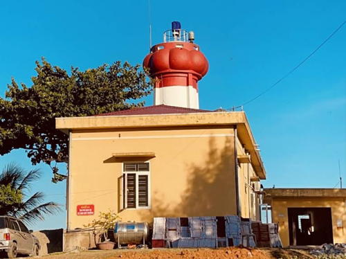
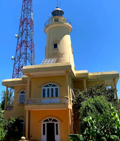
Date unknown. Active; focal plane 78 m (256 ft); three white flashes every 15 s. 24 m (79 ft) round concrete tower with lantern and gallery, rising from a 2-story keeper's house. Entire building painted yellow with white trim. Quỳnh Nguyễn has the 2023 photo at right, Huong Nguyen has a 2015 photo, Tran Anh Hoa has a closeup, and Google has a fuzzy satellite view. Cồn Cỏ is an inhabited island about 23 km (14 mi) northeast of Mũi Lay. Located on the highest point of the island. Site status unknown. Admiralty F3218.25; NGA 20276.8.
* Cửa Tùng
Date unknown. Active; focal plane 45 m (148 ft); four white flashes, in a 3+1 pattern, every 20 s. 27 m (89 ft) round concrete tower with lantern and gallery. Lighthouse painted in black and white spiral bands (an unusual pattern for Vietnam); lantern roof is silver. Lâm Ngọc Đảng has a 2022 photo, Tuấn Vũ has a closeup photo, VMSN has a photo, and Google has a satellite view. Located on the north side of the entrance to the Cửa Tùng estuary, about 8 km (5 mi) south of Mũi Lay. Site open, tower closed. Admiralty F3218; NGA 20276.92.

Cồn Cỏ Light, Quảng Trị, July 2023
Google Maps photo by Quỳnh Nguyễn
* Cửa Việt
1980. Active; focal plane 28 m (92 ft); white flash every 4 s. 22 m (72 ft) square cylindrical masonry tower with a square lantern and gallery, rising from the center of a 3-story masonry keeper's house. The keeper's house is painted yellow and the light tower is gray. A 2018 closeup photo and a distant 2004 photo are available, and Google has a satellite view. The lighthouse was originally painted white. Cửa Việt is just south of the former Demilitarized Zone (DMZ) and was an important American base during the Vietnam War, but this lighthouse was built after the end of the war. Located at the mouth of the Cửa Việt estuary about 25 km (15 mi) north of Quảng Trị. Site open, tower status unknown. ARLHS VIE-014; Admiralty F3216; NGA 20277.

Thừa Thiên–Huế Province Lighthouse
Thuận An (Thai Duong Thuong) (1)
1979. Inactive. 35 m (115 ft) square skeletal tower. A 2019 closeup photo is available, Thuỷ Nguyễn has a 2021 closeup, Hai Che has a photo, and Bing has a satellite view. As of 2023 this tower remains close to the new lighthouse (next entry); Thai Long has a photo of the two towers.
Thuận An (Thai Duong Thuong) (2)
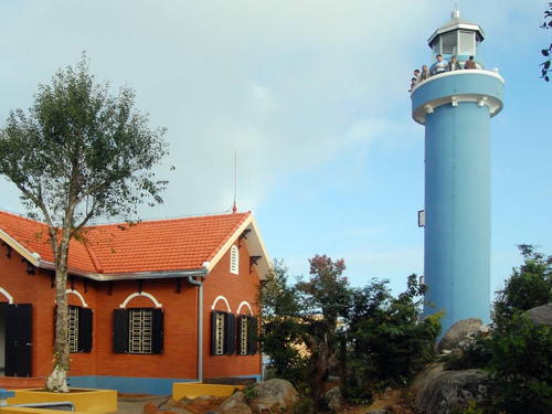
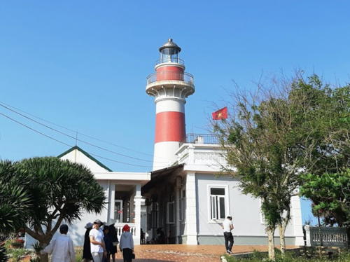
2022 (station established 1979). Active; focal plane 39 m (128 ft); three white flashes every 10 s. 35 m (115 ft) hexagonal concrete tower with lantern and gallery. Lighthouse is white with a red base and red upper section. 1-story keeper's house. Nguyễn Thị Trúc Hạ's 2024 photo is at the top of this page and Google has a satellite view. Located on the southeast side of the entrance to the Tam Giang lagoon near Huế. Site open, tower status unknown. ARLHS VIE-039; Admiralty F3213; NGA 20278.
Chân Mây (Mui Chon May Dong) (2)
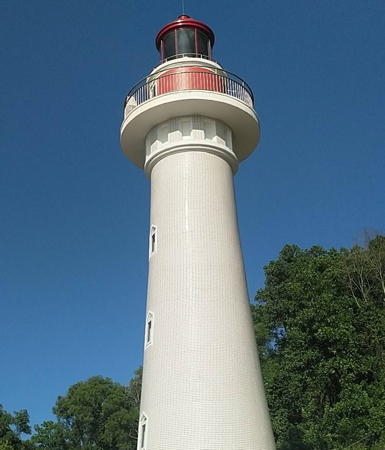
2019 (station established 2001). Active; focal plane 54 m (177 ft); white flash every 5 s. 14 m (46 ft) round concrete tower with lantern and gallery. The tower is white, lantern red. Quang Đông Đào has a January 2020 photo of the new lighthouse (seen at right) and Google has a satellite view. The 2001 lighthouse was a 14 m (46 ft) round hourglass-shaped tower, painted with red and white horizontal bands, centered on the roof of the 2-story station building; the station building was renovated and remains in service. Trabas has Rainer Arndt's photo of the original light, Đông Đào has a 2008 photo. Tám Trần Đức's May 2019 photo shows the renovated station building with the older light still in place but Đông Đào's January 2020 photo shows that it was removed later that year. Located on a promontory about 20 km (13 mi) northwest of Lop An. Site status unknown. Admiralty F3212; NGA 20279.

Chân Mây Light, Thuận An, Jnauary 2020
Google Maps photo by Quang Đông Đào

Đà Nẵng Municipality Lighthouses
Đà Nẵng is Vietnam's fifth largest city and third major port, with a population of about 1.4 million; unlike Hải Phòng and Hồ Chí Minh City (Saigon) it is blessed with a magnificent natural harbor. Called Tourane under French administration, it was a major American base during the Vietnam War.

Sơn Chà
Date unknown. Active; focal plane 240 m (787 ft); three white flashes, in a 2+1 pattern, every 6 s. 15.5 m (51 ft) round cylindrical concrete tower with lantern and gallery, painted light blue with white trim. A 2022 photo is at right, Quang Đông Đào has a 2018 photo, and Google has a satellite view. Located at the summit of Hòn Sơn Chà, an island on the north side of the entrance to Đà Nẵng (Danang), about 2.5 km (1.5 mi) northwest of the Tiên Sa lighthouse. Accessible only by boat. Site status unknown. Admiralty F3211.5; NGA 20279.5.
[Đà Nẵng Dique Oblique]
Date unknown. Active; focal plane about 8 m (26 ft); red flash every 3 s. 6 m (20 ft) round concrete tower painted with red and white horizontal bands. Ngoc Minh Hoang has a photo, Còi Nam has a 2017 photo, Trabas has Douglas Cameron's photo, and Google has a satellite view. Located on a breakwater in the mouth of the Hàn River in the inner harbor of Đà Nẵng. Site open, tower closed. Admiralty F3211; NGA 20316.
Đà Nẵng Detached Breakwater South Head
Date unknown. Active; focal plane about 10 m (33 ft); green flash every 3 s. 8 m (26 ft) round concrete tower painted with green and white horizontal bands. Do Quen has a 2020 photo, Bá Thái Huỳnh has a photo, Nguyễn Hữu Hoà has a night time photo, and Google has a satellite view. Located at the end of the breakwater just south of the Thuận Phước bridge. Accessible only by boat. Site status unknown. Admiralty F3209.2.

Sơn Chà Light, Đà Nẵng, October 2022
Google Maps photo by Phước Official
Đà Nẵng Detached Breakwater North Head
Date unknown. Active; focal plane about 10 m (33 ft); green flash every 3 s. 8 m (26 ft) round concrete tower painted with green and white horizontal bands. Hai Vo has a closeup street view and Google has a satellite view. Located at an elbow (not the actual end) of the long detached breakwater of Đà Nẵng harbor. Accessible only by boat. Site status unknown. Admiralty F3209; NGA 20312.
Quản Tượng (Fort Point, Tourane Bay)
1903. Active; focal plane 42 m (138 ft); white flash every 3 s. 5.5 m (18 ft) round concrete tower, painted white; access to the light is by an external ladder. Quang Đông Đào has a fine closeup 2018 photo and Google has a satellite view. Although it is small this is a historic beacon. Located atop a promontory at the northeastern entrance to Danang Bay. Site status unknown. Admiralty F3206; NGA 20296.
** Tiên Sa (Mũi Đà Nẵng, Sơn Trà, Cape Tourane)
1903. Active; focal plane 158 m (518 ft); two white flashes every 10 s. 9 m (30 ft) round cylindrical masonry tower with lantern and gallery. Formerly painted all white, the lighthouse is now painted white with one yellow horizontal band. A 2022 photo is at right, Nguyễn Phạm Hải Dương also has a 2022 photo, VMS-North has a good photo, Anh Trần has a 2022 photo, Mikhail Eremenko has a photo, Tuấn Anh Nguyễn has a closeup, Nguyen Xuan Duy has a street view, Huelse has a historic postcard view, and Google has a satellite view. The lighthouse is located within the Sơn Trà National Park. Located at the end of the Sơn Trà peninsula, about 20 km (13 mi) northeast of Đà Nẵng (Danang). Site open, photos show the tower is often open. . ARLHS VIE-015; Admiralty F3204; NGA 20292.

Tiên Sa Light, Đà Nẵng, June 2022
Instagram photo by baobei.hyn

Quảng Nam Province Lighthouses
Cửa Đại (Hoi An) (2)
2012 (station established 2000). Active; focal plane 25 m (82 ft); four white flashes, in a 3+1 pattern, every 15 s. 23 m (75 ft) round tower with gallery. Painted white until recently, the lighthouse is now painted with black and white horizontal bands; lantern dome is silver. 2-story keeper's house painted white with a red roof. Trần Đức Tám has a 2021 drone view, Martin Mobers has a February 2013 photo of the new lighthouse, Rafael Alonso has a 2016 photo, Lightphotos.net has a closeup photo and a more distant view, and Google has a satellite view. This lighthouse replaced a 23 m (75 ft) square steel skeletal tower with gallery painted with black and white horizontal bands. Located on the north side of the entrance to the Cửa Đại estuary, east of the city of Hội An. Site status unknown. Admiralty F3203; NGA 20316.5.
Cù Lao Chàm (2)
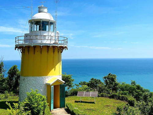
2021 (station established 2003). Active; focal plane 139 m (456 ft); four white flashes, in a 3+1 pattern, every 16 s. 26 m (85 ft) octagonal white concrete tower with lantern and gallery. The light is formerly on a short post centered on the roof of the 2-story concrete keeper's house. A 2023 photo is at right, Hải Xuân has a 2022 photo, a 2023 photo is available, and Google has a satellite view of the station. Quang Đông Đào has a 2019 closeup photo of the earlier light and a distant 2016 drone view is available. Cù Lao Chàm, an island about 15 km (9 mi) northeast of Cửa Đại, has several popular beach resorts and is accessible by ferry from Hội An. Located atop a steep bluff at the northeastern point of the island. Site status unknown. Admiralty F3203.2; NGA 20318.
Tân Hiệp (Tian Hep) (2)
Date unknown (station established 2000). Active; focal plane 42.5 m (139 ft); white flash every 5 s. 11 m (36 ft) round concrete tower painted with black and white horizontal bands. Google has a satellite view.This lighthouse has recently replaced a white skeletal tower. Located on a headland on the east side of the entrance to the harbor of Cù Lao Chàm. Site status unknown. Admiralty F3203.3; NGA 20318.1.
* An Hòa (Kỳ Hà)
1995 (substantially rebuilt in 2016). Active; focal plane 30 m (98 ft); three white flashes, in a 2+1 pattern, every 12 s. 26.5 m (87 ft) round concrete tower with six ribs, lantern and gallery. Lighthouse painted with red and white horizontal bands. Nguyen Tuan Anh has a 2020 phot. Lam Trinh Khac has a December 2016 photo and a street view, M. Quy has a 2023 photo, and Google has a satellite view. Duyên Nguyễn Văn has a 2008 photo showing the original form of the tower. During the rebuilding the light was moved to a square skeletal tower seen in another photo by Khac. Located on a promontory near Núi Thành, about 25 km (15 mi) southeast of Tam Kỳ. Site open, tower closed. Admiralty F3202; NGA 20317.

Cù Lao Chàm Light, Quảng Nam, June 2023
Google Maps photo by Nguyen Tuan Anh

Quảng Ngãi Province Lighthouses
Vạn Ca (Dung Quất) (2)
2000. Active; focal plane about 40 m (131 ft); three white flashes every 10 s. Approx. 20 m (66 ft) round white concrete tower with lantern and gallery. Lantern dome is silver. Thùy Trinh Trịnh has a 2022 photo, Ung Minh Thọ has a closeup photo, Quang Đông Đào has a view from the nearby beach, Thanh Mai has a more distant view, and Google has a satellite view of the station. The previous tower was a 14 m (46 ft) round hourglass-shaped tower centered on the flat roof of a 1-story square keeper's house. The Admiralty continues to describe the earlier lighthouse, which had a focal plane of 32 m (105 ft). Located on a sharp, north-pointing promontory about 10 km (6 mi) southeast of the An Hòa lighthouse. Site status unknown. Admiralty F3200; NGA 20319.
* Lý Sơn (Cù Lao Ré) (3?)
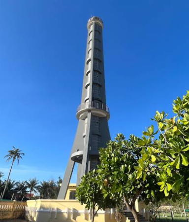
Date unknown (station established 1900). Active; focal plane 50 m (164 ft); white flash every 5 s. 45 m (148 ft) round white concrete tower with two galleries, four ribs, and four buttresses near the base. Nguyễn Quang Huy's 2023 photo is at right, VMS-North has a good photo ,Nguyễn Duy Khoa has a 2023 photo, Lưu Văn Cam has a 2019 closeup photo, Nguyen Huu Anh Vu has a 2024 photo, a March 2007 photo is available, and Google has a satellite view. This is Vietnam's tallest lighthouse. The former light was described by NGA as a black and white metal tower, and there may have been a different French lighthouse earlier. Lý Sơn, formerly called Cù Lao Ré or Canton Island, is an island off Mũi Ba Làng An (Cap Batangan) and about 50 km (30 mi) northeast of Quảng Ngãi. The island has a population of about 20,000 and is accessible by air or by ferry from Sa Kỳ. Tourist facilities are being developed. Located at the northeastern tip of the island. Site open, tower closed. . ARLHS VIE-013; Admiralty F3184; NGA 20320.
Lý Sơn East Beakwater (Mù Cu)
2000. Active; focal plane 11 m (36 ft); four white flashes, in a 3+1 pattern, every 15 s. 10 m (33 ft) round cylindrical concrete tower with gallery, painted with red and white horizontal bands. Quốc Cường Ngô has a closeup photo, Đại Thịnh has a photo, Trung Duc Tran has a 2022 closeup photo, and Google has a street view and a satellite view. Located on a rocky reef at the end of the east breakwater of the harbor at the east end of Lý Sơn. Site status unknown, but presumably there's a good view from ferries arriving at the island. . Admiralty F3184.2; NGA 20320.2.
* Lý Sơn Harbor (An Vĩnh) (2)
Date unknown (station established 2000). Active; focal plane 14.5 m (48 ft); three white flashes every 12 s. 13 m (43 ft) round cylindrical conctete tower painted with black and white horizontal bands. Liên Quân has a 2019 photo, Trần Nguyên Khoa has an overhead drone view, Có Nguyễn Tăng has a street view, and Bing has an indistinct satellite view. The earlier lighthouse was a square cylindrical skeletal tower with gallery, also painted with black and white horizontal bands. Located on the waterfront of the harbor at the west end of Lý Sơn. Site open, tower closed. Admiralty F3184.5.

Lý Sơn Light, Quảng Ngãi, June 2023
Google Maps photo by Nguyễn Quang Huy
* Ba Làng An (Cap Batangan) (4)
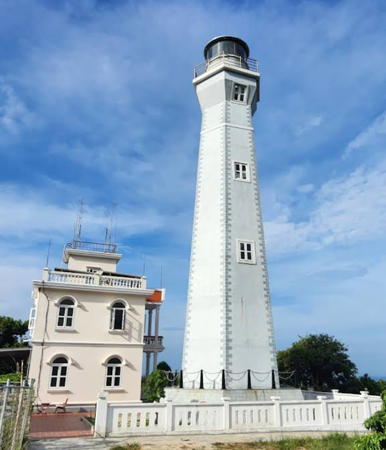
2019 (station established 1915). Active; focal plane about 50 m (164 ft); two white flashes every 6 s. Approx. 25 m (82 ft) round tower with lantern and gallery with lantern and gallery, painted with red and white horizontal bands. 2-story keeper's house painted yellow with white trim. Tú Đoàn's March 2021 photo is seen at right, Ngọc Hoàng Trần has a good 2020 photo, Nhân Nguyễn has a 2022 closeup, and Google has a satellite view of the station. This lighthouse replaced the 1982 light, a short post mounted on the roof of the station building. Võ Hồng Sơn has a closeup photo of the older light. Hùng Nguyễn Việt has a photo of the renovated station building. The original lighthouse was on a lower site with a focal plane height of 25.5 m (84 ft); this appears to be the second light at the present location. Mũi Ba Làng An (Cap Batangan) is a very prominent cape about 25 km (15 mi) northeast of Quảng Ngãi. Located on a headland at the cape. Site open, tower closed. Admiralty F3181; NGA 20321.
Sa Kỳ
2000. Active; focal plane 15 m (49 ft); three white flashes every 10 s. 14 m (46 ft) round cylindrical concrete tower with gallery, painted with red and white horizontal bands. Trung Dung Do has a photo, Văn Cam Lưu has a closeup, and Google has a satellite view. Located on a reef in the entrance to the Sa Kỳ estuary, about 6 km (3.5 mi) southwest of Ba Làng An. Accessible only by boat. Site and tower closed. Admiralty F3180; NGA 20321.2.
Sa Huỳnh (Cap Sa Hoi)
2004. Active; focal plane 87.5 m (287 ft); two white flashes every 10 s. 10 m (33 ft) post on the roof of a 2-1/2 story station building, painted yellow with blue trim and a red roof. Quang Đông Đào has a photo, Nguyen Gia Huy Vo has a 2022 closeup, a 2022 drone view is available, and Google has a satellite view of the station. Located at a harbor entrance about 8 km (5 mi) north of Tam Quan. Site status unknown. Admiralty F3178; NGA 20323.

Ba Làng An Light, Quảng Ngãi, March 2021
Google Maps photo by Tú Đoàn
 

Information available on lost lighthouses:

Notable faux lighthouses:

Adjoining pages: North: Northern Vietnam | South: South Central Vietnam

Return to the Lighthouse Directory index | Ratings key

Posted April 24, 2006. Checked and revised April 14, 2025. Lighthouses: 35. Site copyright 2025 Russ Rowlett and the University of North Carolina at Chapel Hill.