Lighthouses of Equatorial Guinea

The Republic of Equatorial Guinea is the former Spanish Guinea, formed in 1926 by uniting two small, dissimilar Spanish colonies. One part is Bioko, called Fernando Pó under Spanish administration, a volcanic island in the Bight of Biafra off the coasts of Nigeria and Cameroon. The other is Río Muni, a rectangular tract on the African mainland wedged between Cameroon and Gabon. Also included in the country are the islands of Elobey and Corisco off the northwestern coast of Gabon and the remote island of Annobón, 300 km (190 mi) west of the Gabonese coast.

The capital of the country is Malabo (formerly Santa Isabel) at the northern end of Bioko. The major ports are Malabo and Luba on Bioko and Bata in Río Muni. Unfortunately the country is known for extreme income inequality and a poor human rights record; as a result it is not much visited by tourists or vacationers.

Very little information is available on the lighthouses of Equatorial Guinea, so reports and photos would be very welcome.

Spanish is the official language of government in Equatorial Guinea and is spoken by most of its residents. In Spanish isla is an island, cabo is a cape, punta is a promontory or point of land, péñon is a rock, arrecife is a reef, bahía is a bay, ría is an estuary or inlet, estrecho is a strait, río is a river, and puerto is a port or harbor.

ARLHS numbers are from the ARLHS World List of Lights. Admiralty numbers are from volume D of the Admiralty List of Lights & Fog Signals. U.S. NGA List numbers are from Publication 113.

General Sources
Online List of Lights - Bioko, West Coast (Río Muni), and Pagalu (Annobón)
Photos by various photographers posted by Alexander Trabas.
World of Lighthouses - Equatorial Guinea
Photos by various photographers available from Lightphotos.net.
Afrikanische Leuchttürme auf historischen Postkarten
Postcards from the collection of Klaus Huelse.
Map of Equatorial Guinea
From NationsOnline.org.


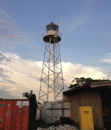
Punta Europa Light, Malabo, April 2013
anonymous contributed photo; used by permission
Annobón Province Lighthouses
Annobón (also called Pagalu) is the southernmost island of the Cameroon Line, a 1,600 km (1,000 mi) long chain of volcanoes extending southwest from Mount Cameroon on the mainland. It is separated from Bioko by the former Portuguese islands of São Tomé and Principe. Annobón is accessible by air and has a population of about 5300.

Mission de Santo Antonio
Date unknown. Active (?); focal plane 46 m (151 ft); white flash every 4 s. 7 m (23 ft) masonry tower, painted white. No photo available. The Spanish edition of Wikipedia mentions the lighthouse but it has not been located for certain. Wikimapia has an aerial view in which the lighthouse is probably seen atop the hill at the far left and Google has a satellite view of a possible location suggested by the aerial view. Located on the heights of Punta del Palmar, the northern tip of the island, above Santo Antonio de Palé, the principal village on the island. Site status unknown. ARLHS EQG-009; Admiralty D4248; NGA 25208.
Pointe Santo Antonio (Punta Manjob)
Date unknown. Active (?); focal plane unknown; red light occulting four times every 12 s. No description available and the light is not seen in Google's satellite view of the listed location. Located on the southern tip of Annobón. Site status unknown. Admiralty D4249; NGA 25210.

Litoral Province (Río Muni) Lighthouses
Río Muni (called Mbini in the indigenous Fang langauge) is a rectangular region on the African continent bordered by Gabon to the south and west and by Cameroon to the north. Its population of 885,000 in 2015 represented almost three quarters of the population of Equatorial Guinea.

[Isla de Corisco]
Date unknown. Probably inactive; listed with focal plane 28 m (92 ft); white flash every 4 s. 3 m (10 ft) red square tower. No photo available and the light is not seen in Google's satellite view. Most likely it has disappered into the jungle. Corisco is a small island 29 km (18 mi) southwest of the mouth of the Río Muni. Located at the northern tip of the island. Site status unknown. Admiralty D4200; NGA 25300.
* Port de Cogo
Date unknown. Apparently inactive but still listed by NGA with focal plane 32 m (105 ft); white, red, or green light, depending on direction, 2 s on, 2 s off. 16 m (52 ft) slender square skeletal tower. NGA describes the tower as red, but more likely it is white. No closeup photo available but Huelse has a postcard view of a triangular skeletal tower having approximately the right height. This view matched the white tower seen in a 2005 aerial view of the town formerly available from Panoramio. The tower is barely visible (just below a large tree) in Google's satellite view and as a white spot in Bing's satellite view. The lighthouse guided ships northeastward into the port of Cogo, on the Río Muni estuary at the southern edge of the country. Site status unknown, probably open; tower closed. ARLHS EQG-008; ex-Admiralty D4210; NGA 25288.
Cabo San Juan
Date unknown. Active (?); focal plane 24 m (79 ft); two red flashes every 10 s. 18 m (59 ft) "red pylon," according to the NGA listing, but Bing's satellite view appears to show a square skeletal tower. with several station buildings. No photo available. Located on a prominent cape near the southwesternmost point of Río Muni. Accessible only by boat. Site status unknown. Admiralty D4190; NGA 25276.
Punta Mbode
Date unknown. Active (?); focal plane 14 m (46 ft); four quick white flashes every 9 s. 12 m (39 ft) skeletal tower. No photo available and the tower is not seen in Google's satellite view of the cape. Located on a cape on the north side of the entrance to Mbini. Site status unknown. Admiralty D4176; NGA 25264.
Punta Ngaba
Date unknown. Active (?); focal plane 19 m (62 ft); white flash every 5 s. 24 m (79 ft) metal tower on a concrete base. No photo available and the tower is not seen in Google's satellite view of the cape. Located on a cape about 15 km (9 mi) southwest of Bata. Site status unknown. Admiralty D4175.5; NGA 25260.
Punta Mbonda
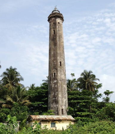
Date unknown. Active (?); focal plane 36 m (119 ft); four white flashes, in a 3+1 pattern, every 20 s. 35 m (115 ft) octagonal brick tower. Juanjo Crespo has a 2013 closeup is at right, Mike Fleming contributed an aerial view, another photo (halfway down the page) is available, and Google has a satellite view. In recent years Punta Mbonda has been a restricted area, the site of military camps and a prison. Located on a point of land about 30 km (19 mi) north of Bata. Site and tower closed. ARLHS EQG-003; Admiralty D4170; NGA 25248.

Punta Mbonda Light, Río Muni, December 2013
Google Maps photo by Juanjo Crespo

Bioko Sur Province (South Bioko) Lighthouses
Bioko is an island, about 70 km (43 mi) long and 32 km (20 mi) wide, located in the Bight of Biafra only 32 km (20 mi) off the coast of Cameroon. The island had a population of 335,000 in 2015; it includes the national capital of Malabo.

Frontón de Caracas
Date unknown. Active; focal plane 19 m (62 ft); three flashes, white or red depending on direction, every 12 s. 8 m (26 ft) pyramidal tower, painted white. No photo available and the light is not seen in Bing's satellite view. Located on a headland about 8 km (5 mi) northeast of Riaba. Site status unknown. ARLHS EQG-007; Admiralty D4064; NGA 25160.
* Riaba (Concepción) (?)
Date unknown. Active(?); focal plane unknown; flash every 5 s, white, red or green depending on direction. 6 m (20 ft) square white masonry tower with gallery but no lantern. No photo available and the light is not seen in Google's satellite view. Riaba, known as Concepción in Spanish times, is a small port on the east coast of Bioko. More information needed. Site appears open, tower closed. ARLHS EQG-006; Admiralty D4060; NGA 25164.
Punta Santiago
Date unknown. Active; focal plane 80 m (262 ft); three white flashes, in a 2+1 pattern, every 20 s. 25 m (82 ft) skeletal tower. No photo available and and the light is not seen in Bing's satellite view. Located at the southern tip of Bioko. Site status unknown. Admiralty D4056; NGA 25156.
* Punta Barceloneta (Luba, San Carlos)
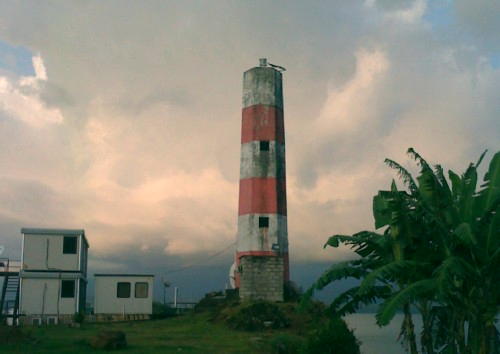
Date unknown. Active; focal plane 45 m (148 ft); four flashes, white or red depending on direction, every 15 s. 16 m (52 ft) hexagonal masonry tower with gallery; no lantern. Lighthouse painted with horizontal red and white bands. A 2008 closeup photo is at right, Trabas has Bjørn Poulsen's 2014 photo showing the lighthouse freshly repainted, Dieter Schroeter has a distant view, there is a postage stamp view, and Google has a satellite view. The lighthouse marks the southern entrance to the Bahía de Luba on the west coast of Bioko. (Luba was called San Carlos in colonial times.) A modern port has been built recently at Luba to support the natural gas fields offshore to the west. Located on the point, about 1.5 km (1 mi) northwest of Luba. Site appears open, tower closed. ARLHS EQG-005; Admiralty D4046; NGA 25144.
* Puerto de Luba
Date unknown. Active; focal plane 30 m (98 ft); white, red or green light depending on direction, occculting twice every 6 s. Approx. 20 m (66 ft) tower painted with black and white horizontal bands. The light is to the right of the tall building in Trần Hoàng's distant view of the harbor and Google has a fuzzy satellite view. Located about 250 m (1/8 mi) south of the main pier in Luba harbor.Site status unknown but the light would be easy to see from nearby. Admiralty D4051; NGA 25146.

Punta Barceloneta Light, Luba, November 2008
ex-Google Maps photo by lescalanteg

Bioko Norte Province (North Bioko) Lighthouses
Punta Europa
Date unknown. Active; focal plane 71 m (233 ft); three white flashes, separated by 4 s, every 20 s. Approx. 20 m (66 ft) square skeletal tower with lantern and gallery, painted white. A photo is at the top of this page and Google has a satellite view. Punta Europa is the location of the island's main power plant, fired by natural gas from offshore wells, and Marathon Oil has constructed a large liquified natural gas plant there. Located within the Marathon plant on the northwestern tip of Bioko, about 10 km (6 mi) northwest of Malabo. Site and tower closed. ARLHS EQG-002; Admiralty D4040; NGA 25112.
* Ensenada de Gravina
Around 2010 (?). Active; focal plane about 17 m (56 ft); red or yellow flash, depending on direction, every 6 s. Approx. 13 m (43 ft) round barbell-shaped tower colored with red and white horizontal bands. A 2019 photo is at right but the light is hard to see in Google's fuzzy satellite view. This is the leading light for approaching the harbor of Malabo. Located on the waterfront of the harbor. Site open, tower closed. Admiralty D4038.
* Muelle Vieja
Around 2010 (?). Active; focal plane about 17 m (56 ft); red light, pattern unknown. Approx. 13 m (43 ft) round barbell-shaped tower. A distant view and a second distant view are available and Google has a satellite view. This is a leading light for entrance to the harbor of Malabo. Located on the waterfront of the harbor about 3 km (2 mi) west of the main basin. Site open, tower closed. Admiralty D4030.
Bahia de Malabo
Date unknown. Active; focal plane about 12 m (39 ft); green light, pattern unknown. Approx. 8 m (26 ft) concrete tower. With zoom the light is visible in a 2019 view of the quay and Google has an indistinct satellite view. Located on the corner of a major quay on the west side of Malabo harbor. Site and tower closed. Admiralty D4034.

Ensenada de Gravina Light, Malabo, December 2019
Google Maps photo by Jay
Malabo East Breakwater
Date unknown. Active; focal plane about 12 m (39 ft); red light, pattern unknown. Approx. 8 m (26 ft) concrete tower. With zoom the light is visible at the end of the breakwater in a 2019 view and Google has an indistinct satellite view. Located on theend of the breakwater extending from the Punta de la Unidad Africana. Site and tower closed. Admiralty D4033.5.
* Punta de la Unidad Africana (Punta Fernanda, Fernando Póo) (3?)
Around 2014 (station established 1866). Probably active; focal plane about 15 m (49 ft); red light occulting four times every 12 s. 8 m (26 ft) mast painted with red and white horizontal bands and rising from a sqaure pyramidal base. With zoom the light is seen at the end of the bluff in a distant view and Google has a satellite view. This tower replaced an 8 m (26 ft) square masonry tower. The light was dropped from the Admiralty list in 2012 but it remains listed by NGA with the correct description "column, pyramid." There was extensive redevelopment of the port around 2008. The Punta de la Unidad Africana is a narrow, curving peninsula (the caldera rim of an ancient volcano) that has been sculpted into a breakwater protecting the east side of the harbor at Malabo. Located at the tip of the point. Site open, tower closed. ARLHS EQG-004; ex-Admiralty D4032; NGA 25120.
Islote Horacio
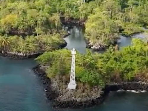
Date unknown. Active (?); focal plane 22 m (72 ft); white flash every 4 s. 16 m (52 ft) square white skeletal tower. An aerial view from a YouTube video is at right and Google has a distant satellite view. Located on an islet off the northeastern tip of Bioko, about 18 km (11 mi) northeast of Malabo. Accessible only by boat. Site status unknown. ARLHS EQG-001; Admiralty D4028; NGA 25136.

Information available on lost lighthouses:

  • San Carlos (1907-?), Luba. No additional information is available. ARLHS EQG-010.

Notable faux lighthouses:


Islote Horacio Light, Malabo, 2016
Frame at 2:56 from You Tube video, "Welcome to the Republic of Equatorial Guinea"

Adjoining pages: North: Cameroon | South: Gabon | West: São Tomé and Principe

Return to the Lighthouse Directory index | Ratings key

Posted September 14, 2005. Checked and revised April 26, 2025. Lighthouses: 19. Site copyright 2025 Russ Rowlett and the University of North Carolina at Chapel Hill.