Lighthouses of Malaysia: Sarawak

The nation of Malaysia is in two parts: Peninsular Malaysia (also called West Malaysia or Malaya) on the southern end of the Malay Peninsula and Malaysian Borneo (East Malaysia) on the island of Borneo roughly 700 km (450 mi) to the east. East Malaysia includes two former British colonies, Sarawak and Sabah, plus a smaller territory called Labuan. Another former British protectorate in Borneo, Brunei, is an independent enclave surrounded by East Malaysia. Sarawak was ruled from 1842 to 1946 by Sir James Brooke and his descendents, who were known as the "White Rajahs," while Sabah was controlled by the British North Borneo Company from 1881 to 1946. Redesignated as crown colonies in 1946, both regions were incorporated states of the independent Malaysia in 1963.

Malaysia is a federal constitutional monarchy consisting of thirteen states and three federal territories. Sarawak is the largest of the states. The coast of Sarawak faces northwest on the South China Sea. Many of its lighthouses are in remote areas, so they attract few visitors. For administration Sarawak is divided into twelve divisions.

In March 2022 the Transport Ministry of Sarawak announced plans to restore and upgrade seven lighthouses: Tanjung Dato, Tanjung Po, Tanjung Jerijeh, Tanjung Sirik, Tanjung Kidurong, Tanjung Lobang and Tanjung Baram.

Malay is the official language of Malaysia; English is also a "recognized" language. The Malay term for a lighthouse is rumah api ("house of fire"); pulau is an island, terumbu is a reef, tanjung is a cape, bukit is a hill, sungai is a river, kuala is the mouth of a river, teluk is a bay, selat is a strait, and pelabuhan is a harbor.

Aids to navigation in Malaysia are the responsibility of the Marine Department (Jabatan Laut), an agency of the Ministry of Transport. Sarawak and Sabah formerly had independent marine departments, but they were merged with the Peninsular Malaya marine department in 2011.

Special thanks to Ezmil Sahrani of GreenFinder Asia for permission to post several of his photos on this page.

ARLHS numbers are from the ARLHS World List of Lights. MY numbers are Malaysian light list numbers, where known. Admiralty numbers are from volume F of the Admiralty List of Lights & Fog Signals. U.S. NGA List numbers are from Publication 112.

General Sources
Lighthouses of Malaysia
Photos posted by Greenfinder.asia, a navigational aids and maritime services company. Most if not all of these photos are by Ezmil Sahrani.
Online List of Lights - Sarawak
Photos by various photographers posted by Alexander Trabas.
Lighthouses in Malaysia
Photos by various photographers available from Wikimedia.
Malaysian Lighthouses
Historic postcard views posted by Michel Forand.
GPSNavigationCharts
Navigational chart information for East Malaysia.
Navionics Charts
Navigational chart for East Malaysia.

Tanjung Po Light, Kuching
photo by Ezmil Sahrani courtesy of Greenfinder.asia
Kuching Division Lighthouses
Kuching is the capital and largest city of Sarawak with a population of more than half a million. The city's harbor is the estuary of the Sarawak River.
Tanjung Datu (Datok) (1, 2 and 3)
Dates uncertain (station established 1884). Active; focal plane roughly 200 m (656 ft); white flash every 15 s. We are much in need of a complete history of this light station, which marks the border between Indonesian Kalimantan and Sarawak. The border is the site of dueling light stations, one on the Malaysian side and one on the Indonesian side. Both lights are active; the Indonesian lighthouse (Admiralty F1893.2) displays two long (1.5 s) white flashes every 12 s. Rizall Udin's 2021 photo at right shows three generations of lighthouses on the Malaysian side, beginning with an 8 m (26 ft) round cylindrical concrete tower with lantern. The Admiralty continues to describe that light. The second lighthouse, at the right in the photo, carries the Malaysian flag while the third lighthouse is a square skeletal tower probably 30 m (98 ft) tall, painted with red and white horizontal bands. Google has a satellite view of the station. In Rendi Sidu's 2023 photo, the oldest Indonesian lighthouse is in the foreground with the three Malaysian lighthouses just a few feet away across the border. The surrounding area in Malaysia is an undeveloped national park. In 2014 Malaysia began construction of a new light on a platform off the point of the cape; construction was halted when Indonesia protested that the location was in Indonesian waters as provided by a 1969 treaty. A blog has a lengthy discussion of this controversy from the Indonesian point of view. The onshore Malaysian lighthouse was restored and upgraded in 2017; the tall tower may have been built at that time. Located on a promontory at the tip of the Datu Peninsula about 50 km (30 mi) northwest of Sematan. Boat transportation to the park can be arranged in Sematan. Site open, tower closed. Site manager: Tanjung Datu National Park. MY-1001; Admiralty F1894; NGA 23872.
Tanjung Sipang (Santubong)
Date unknown (recent). Active; focal plane about 25 m (82 ft); white flash every 7.5 s. Approx. 12 m (39 ft) round white fiberglass tower, flared at the top. Wilson Chin has a photo and a drone view, Safarudin Din has a 2019 photo, and Google has a satellite view. Located at the tip of a rugged peninsula about 30 km (19 mi) north of Kuching, the capital of Sarawak. Accessible only by boat. Site status unknown. Admiralty F1896.85; NGA 23906.
Tanjung Patang
Date unknown. Active; focal plane 15 m (49 ft); two yellow flashes every 5 s. 15 m (49 ft) white concrete tower mounted on tripod concrete piles. No photo available but Bing has a distant satellite view. Located on the north point of a reef about 5 km (3 mi) northwest of Tanjung Po. Accessible only by boat. Site open, tower closed. Admiralty F1897.6; NGA 23910.
Tanjung Po
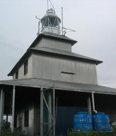
1873. Active; focal plane 131 m (430 ft); two white flashes every 10 s. 15 m (49 ft) lantern centered on the roof of a square pagoda-like wood keeper's house. The house has been covered with white siding, and the lantern is painted white. Ezmil Sahrani's closeup photo is at the top of this page, Ian Vong has a 2020 drone view, and Google has a satellite view. Located on a promontory about 40 km (25 mi) northeast of Kuching, the capital of Sarawak. Site status unknown. ARLHS EMA-012; Admiralty F1898; NGA 23916.


Tanjung Datu Lights, Sarawak, February 2021
Google Maps photo by Rizall Udin

#Tanjung Batu (1)
Date unknown. Active; focal plane 9 m (30 ft); quick-flashing green light. This was an 8 m (26 ft) white fiberglass tower. No photo available but Bing has a distant satellite view. A 2016 photo shows that the light is now on a tall mast. Located on a low point projecting into the Sarawak River, Kuching's harbor. Site status unknown. Active light: Admiralty F1901.6; NGA 23940.
Kuching Entrance Range Front
Date unknown. Active; focal plane 21.5 m (70 ft); two white flashes every 6 s. Approx. 19 m (59 ft) skeletal tower carrying a daymark with yellow vertical stripes and a red diamond. Google has a street view and a satellite view. This is the entrance range for the Sarawak River. Site status unknown. Admiralty F1901; NGA 23928.
* Kuching Entrance Range Rear
Date unknown. Active; focal plane 30.5 m (100 ft); two white flashes every 6 s. Approx. 25 m (82 ft) skeletal tower carrying a daymark with yellow vertical stripes and a red diamond. Google has the street view at right and a satellite view. Located about 760 m (1/2 mi) southwest of the front light. Site status unknown, but the tower is easily seen from nearby roads. Admiralty F1901.1; NGA 23932.
Tanjung Renard
Date unknown. Active; focal plane 15 m (49 ft); quick-flashing green light. Approx. 13 m (43 ft) white fiberglass tower. No photo available and trees hide the light in Google's satellite view. Located on the inside point of a sharp bend in the Sarawak River. Site status unknown. Admiralty F1902.2; NGA 23944.
Tanjung Embang Range Front
Date unknown. Active; focal plane 21.5 m (70 ft); white light, 1 s on, 1 s off. Approx. 18 m (56 ft) skeletal tower carrying a daymark with yellow vertical stripes and a red diamond. No photo available but Google has a satellite view. This is the approach range for Kuching. Located on the south side of the entrance to the Sarawak River. Site status unknown. Admiralty F1900; NGA 23920.
Tanjung Embang Range Rear
Date unknown. Active; focal plane 30.5 m (100 ft); white light occulting once every 10 s. Approx. 25 m (82 ft) skeletal tower carrying a daymark with yellow vertical stripes and a red diamond. No photo available but Google has a satellite view. Located about 760 m (1/2 mi) southwest of the front light. Site status unknown. Admiralty F1900.1; NGA 23924.


Entrance Range Rear Light, Kuching, October 2018
Google Maps street view


Sarikei Division Lighthouses
Pasir Wong (Wong Sands)
2009. Active; focal plane 11 m (36 ft); white flash every 7.5 s. 11 m (36 ft) tower, no description available. No photo available and the tower is not shown in Bing's satellite view. Located off the south side of the entrance to the Serikai River. Accessible only by boat. Site open, tower closed. Admiralty F1909.1; NGA 24078.
Tanjung Selalang
Date unknown. Active; focal plane 16.5 m (53 ft); white flash every 5 s. 17 m (56 ft) square skeletal tower with lantern and gallery, painted white. No photo available but Google has a satellite view. Located on a low point of land on the south side of the entrance to the Serikai River. Site status unknown. Admiralty F1909.4; NGA 24076.
Tanjung Jerijeh (2)
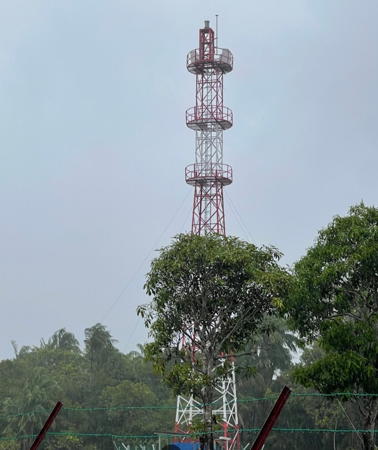
2021 (?) (station established 1936). Active; focal plane 38 m (125 ft); three white flashes every 15 s. 36 m (118 ft) square skeletal tower with lantern and three galleries, painted with red and white. horizonyal bands. Keeper's house and other light station buildings. Phoo Wei's 2022 photo is at right and Google has a satellite view. Ezmil Sahrani has a photo of the original tower. Located on the north side of the entrance to the Serikai (Jerijeh?) River. Site status unknown. Admiralty F1908; NGA 24068.

Mukah Division Lighthouses
Tanjung Sedi (2)
Date unknown. Active; focal plane 21.5 m (70 ft); white flash every 5 s. 18 m (59 ft) tower carrying a white diamond-shaped daymark, mounted on a square pier. No photo available but Bing has a satellite view. In another satellite view the square keeper's house of the original lighthouse is seen onshore. NGA lists a 10 m (33 ft) skeletal tower for this light. Located just off the southwestern corner of Pulau Bruit, marking the approach to Kuala Paloh. Accessible only by boat. Site status unknown. Admiralty F1914; NGA 24088.
Kuala Paloh
Date unknown. Active; focal plane unknown; four white flashes every 20s. No description available, but this is surely a skeletal tower on a platform supported by piles. The range is listed as 16 nautical miles (29.5 km or 18.5 mi); this would imply a tower at least 30 m (98 ft) tall. No photo available, and the tower is not seen in Bing's satellite view. Located about 15 km (9 mi) northwest of the entrance to Kuala Paloh. Accessible only by boat. Site open, tower closed. Admiralty F1913.9; NGA 24093.

Tanjung Jerijeh Light, Serikei Division, May 2002
Googke Maps photo by Phoo Wei
Tanjung Sirik (2)
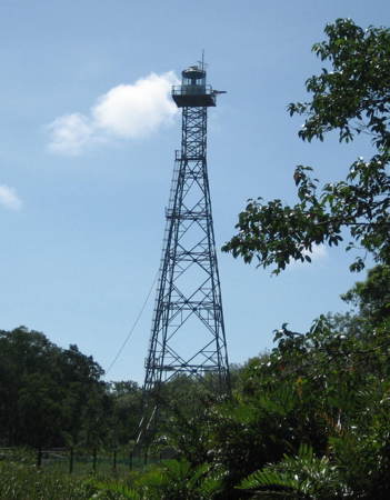
1988 (station established 1882). Active; focal plane 38 m (125 ft); white flash every 10 s. 36 m (118 ft) square pyramidal steel skeletal tower with lantern and gallery, painted white. Keeper's house and other station buildings. Sahrani's photo is at right, a small photo is available, and Bing has an indistinct satellite view of the station. This light marks a major change in the direction of the coastline, from north-south to east-west. The original lighthose was described in 1904 as a "wood and iron" tower. The site is probably accessible only by boat. Located at the northern tip of Pulau Bruit, about 100 km (60 mi) northwest of Sibu. Site status unknown. ARLHS EMA-013; Admiralty F1916; NGA 24104.
Kuala Balingian (Batang Balingian)
Date unknown. Active; focal plane 15 m (50 ft); two white flashes every 6 s. 18 m (59 ft) white metal skeletal tower. No photo available and the tower is not seen in Google's satellite view. Located on the east side of the entrance to Balingian. Accessible only by boat. Site open tower closed. Admiralty F1923.41; NGA 24140.

Bintulu Division Lighthouses
Bintulu, the division capital, is a city of about 120,000 residents. Oil and gas discovered just off the coast in 1969 have made it an important port and industrial center. Tanjung Kidurong, the port area of northern Bintulu, includes a very large liquified natural gas facility.

#Kuala Bintulu Range Rear (?)
Date unknown. Active; focal plane 20 m (66 ft); continuous green light. Approx. 18 m (59 ft) square white skeletal tower carrying a triangular daymark, point down. Google has a closeup 2018 street view. This light is missing from a 2019 street view and the current satellite view so it has been demolished or perhaps relocated. The front light was on a shorter skeletal tower. The range lights continue to be listed by the Admiralty and charted by Navionics. Formerly located at an intersection next to the Golden Bay Hotel on Tun Razak Street in downtown Bintulu. Site open, tower closed. Admiralty F1924.1; NGA 24160.
Bintulu (Tanjung Kidurong) South Access Channel Range Rear
Date unknown. Active; focal plane about 35 m (115 ft); light characteristic unknown. Approx. 30 m (98 ft) square skeletal tower. No photo available but Google has a satellite view and a very distant street view. The front light is on the north breakwater of the south harbor. Located on the waterfront of the south harbor at Tanjung Kidurong. Site status unknown. Admiralty F1925.051.

Tanjung Sirik Light, Pulau Bruit
photo by Ezmil Sahrani courtesy of Greenfinder.asia
Bintulu (Tanjung Kidurong) Outer Range Front
Date unknown. Active; focal plane 30 m (98 ft); white light, 6 s on, 6 s off, synchronized with the rear light. Approx. 26 m (85 ft) skeletal tower carrying a white trapezoidal daymark. Manoj Kumar has a view from the sea and Google has a satellite view. Located on the south side of the entrance to the main harbor of Tanjung Kidurong. Site status unknown. Admiralty F1925.2; NGA 24172.
Bintulu (Tanjung Kidurong) Outer Range Rear
Date unknown. Active; focal plane 45 m (148 ft); white light, 6 s on, 6 s off, synchronized with the front light. Approx. 41 m (135 ft) square skeletal tower carrying a white trapezoidal daymark. Google has a street view and a satellite view. Located 840 m (0.52 mi) east of the front light. Site status unknown.
Admiralty F1925.21; NGA 24176.
Bintulu (Tanjung Kidurong) Inner Range Front
Date unknown. Active; focal plane 12 m (39 ft) (?); red light, 3 s on, 3 s off, synchronized with the rear light. 18 m (59 ft) skeletal tower carrying a red trapezoidal daymark. Google has a street view and a satellite view. Located on the waterfront of Tanjung Kidurong. Site status unknown. Admiralty F1925.3; NGA 24177.
Bintulu (Tanjung Kidurong) Inner Range Rear
Date unknown. Active; focal plane 16 m (52 ft) (?); red light, 3 s on, 3 s off, synchronized with the rear light. 22 m (72 ft) skeletal tower carrying a red trapezoidal daymark. Google has a street view and a satellite view. Located 200 m (220 yd) east of the front light. Site status unknown. Admiralty F1925.31; NGA 24178.
Bintulu (Tanjung Kidurong)
1988 (station established 1878). Active; focal plane 90 m (295 ft); two white flashes every 15 s. 21 m (69 ft) square aluminum skeletal tower with lantern and gallery. Lighthouse painted white. No photo available but Google has a satellite view. Located on the north side of the port entrance. Site status unknown. Admiralty F1925; NGA 24168.
Tanjung Payong
Date unknown. Active; focal plane 23 m (75 ft); white flash every 10 s. 9 m (30 ft) round white fiberglass tower with a flared top. No photo available but Bing has an indistinct satellite view. Located on a headland about 80 km (50 mi) northeast of Tanjung Kidurong. Site status unknown. Admiralty F1925.8; NGA 24184.

Miri Division Lighthouses
* Miri (Tanjung Lobang) (3)
1988 (station established 1930s). Active; focal plane 47 m (154 ft); white flash every 10 s. 16 m (52 ft) square steel skeletal tower with gallery and enclosed upper section but no lantern. Lighthouse painted white. The Borneo Post has a photo, the city has a page for the lighthouse, Alvin Johnson has a photo, and Google has a street view and a satellite view. A British lighthouse here was destroyed by Japanese troops in 1942; it was replaced by another skeletal tower. Close to roads and buildings, this lighthouse is accessible. Located on a promontory just south of Miri. Site open, tower closed. Admiralty F1930; NGA 24216.
Baram (Tanjung Baram)
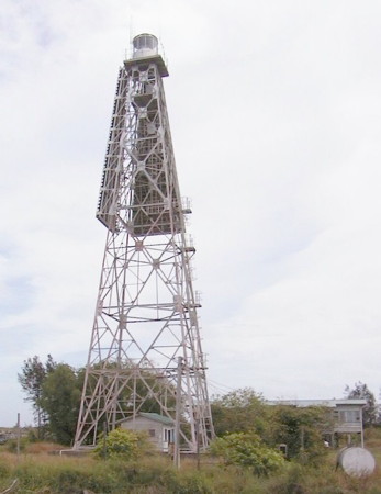
1936 (station established 1892). Active; focal plane 47 m (154 ft); three white flashes every 20 s. 45 m (148 ft) square steel skeletal tower with lantern and gallery, painted white. Two sides of the upper half of the lighthouse carry a slatted daymark painted with a red and white checkerboard pattern. A Marine Department photo is at right, Ezmil Sahrani has a photo, a 2024 closeup is available, and Google has a satellite view. This lighthouse, only 5 km (3 mi) west of the Brunei border, stands on a prominent cape and helps guide ships approaching Brunei. Located on the north side of the Baram River entrance at Kuala Baram. Site status unknown. Admiralty F1934; NGA 24240.
Tanjung Baram Light
Tanjung Baram Light
Malaysian Marine Department photo (no longer online)

Information available on lost lighthouses:

Notable faux lighthouses:

Adjoining pages: North: Spratly Islands | Northeast: Brunei | Southwest: West Kalimantan | West: Natuna Sea Islands

Return to the Lighthouse Directory index | Ratings key

Posted March 21, 2006. Checked and revised April 16, 2024. Lighthouses: 27. Site copyright 2024 Russ Rowlett and the University of North Carolina at Chapel Hill.