Lighthouses of the Netherlands: North Holland

A small country with a long maritime tradition, The Netherlands (Nederland in Dutch) is home to a large number of historic lighthouses. For centuries fires were lit atop brick towers to guide returning Dutch sailors, and even today the traditional Dutch word for a lighthouse is vuurtoren (fire tower).

The Netherlands is divided into twelve provinces (provincies), and the provinces are subdivided into municipalities (gemeenten). The name Holland is often used informally to refer to all of the Netherlands, but properly (and historically) it describes the coastal region between the Rhine/Maas delta and the entrance to the Zuiderzee (now the IJsselmeer). This page includes lighthouses of the province of Noord-Holland (North Holland) This region includes the IJmuiden, Den Helder, and Amsterdam areas. It faces west on the North Sea and east on the IJsselmeer.

The IJsselmeer is the shallow freshwater lake stretching northeast from Amsterdam, the remnant of the former Zuiderzee cut off from the sea since 1932 by the Afsluitdijk dam and causeway. More than half the original area of the Zuiderzee has been reclaimed as dry land by Rijkswaterstaat IJsselmeergebied, the IJsselmeer Directorate, an agency of the Ministry of Transport and Waterways. In 1975 a second dam was completed across the center of the IJsselmeer, from south of Enkhuizen to Lelystad, cutting off the southwestern part of the IJsselmeer as a separate lake called the Markermeer. The Markermeer was to be drained but this project has been postponed indefinitely and may never be carried out.

There is strong interest in the country in lighthouses and their preservation and many towers have been restored in recent years.

Lighthouses in the Netherlands are maintained by the Rijkswaterstaat, the ministry of infrastructure and water management. Lighthouses of the IJsselmeer are maintained by a separate division of the ministry, the Rijkswaterstaat IJsselmeergebied, formerly called RDIJ. In recent years there has been a movement to transfer some of the historic towers to the ownership of municipal authorities.

The digraph IJ or ij acts as an additional letter in the Dutch alphabet. In Dutch vuurtoren is a lighthouse, lichtopstand is a smaller light beacon, baken is an unlit beacon, eiland is an island, ondiepte is a shoal or reef, baai is a bay, zeestraat is a strait, zeegat is an estuary or harbor mouth, kaap is a cape or headland, sluis is a lock, dijk is a dike, rivier is a river, and haven is a harbor.

ARLHS numbers are from the ARLHS World List of Lights. NL numbers are from the official Dutch list Lichtenlijst van Nederland en aangrenzend gebied. U.K. Admiralty numbers are from volume B of the Admiralty List of Lights & Fog Signals. U.S. NGA numbers are from Publication 114. The international light lists do not include the lights of the IJsselmeer and Markermeer.
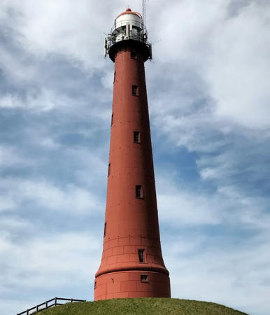

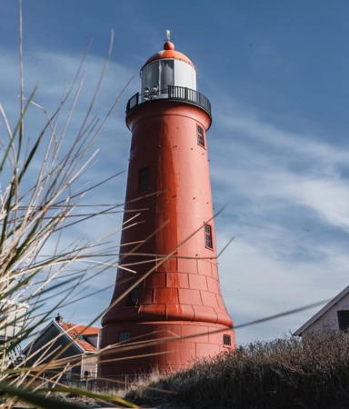
IJmuiden Range Rear Light, Velsen, April 2023
Instagram photo by leanvthooft
General Sources
Nederlandse Vuurtoren Vereniging
Web site of the Netherlands Lighthouse Association. The site includes an interactive map leading to information about each lighthouse.
Online List of Lights - Netherlands - West Coast
Photos by various photographers posted by Alexander Trabas. Many photos are by Capt. Peter Mosselberger ("Capt. Peter").
Leuchttürmseiten von Anke und Jens - Netherlands
This site has photos and information on many of the lights.
Leuchttürme.net - Niederland
Photos and text posted by Malte Werning.
Les Sentinelles des Mers - Pays-Bas
Photos and information by Guy Detienne.
Netherlands Lighthouses
Excellent aerial photos posted by Marinas.com.
Lighthouses of the Netherlands
Excellent photos by Marc de Kleijn, including larger versions of his photos shown on this page.
Nederlandse Vuurtorens
Excellent photos and lighthoiuse information by Dennis Nijhuis.
Netherlands Lighthouses
Photos by Larry Myhre.
Phares d'Europe
Photos posted by Alain Guyomard and Robert Carceller, including about 20 Dutch (Pays-Bas) lighthouses.
Lighthouses in the Netherlands
Photos available from Wikimedia.
World of Lighthouses - Netherlands
Photos by various photographers available on Lightphotos.net.
List of Lights for the Dutch Coast and Adjacent Areas
The official Dutch light list is available for download.
Netherlands Lighthouses
Historic postcard views posted by Michel Forand.
Holländische Leuchttürme und Feuerschiffe auf historischen Postkarten
Historic postcard views posted by Klaus Huelse.
GPSNavigationCharts
Navigation chart information for the Netherlands

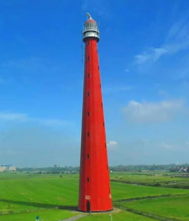
Lange Jaap, Den Helder, October 2021
Instagram photo by lighthousepics
Velsen (IJmuiden Area) Lighthouses
The North Sea Canal (Noordzeekanaal), completed in 1876, connects Amsterdam to the North Sea at IJmuiden. The IJmuiden lighthouses are all associated with the entrance to the canal.

* IJmuiden Nieuwe Zuiderhoofd (New South Breakwater)
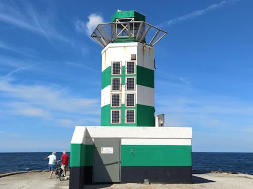
1966. Active; focal plane 15 m (50 ft); continuous green light; there is also a white light, flash every 3 s, shown only during fog. Approx. 12 m (40 ft) hexagonal cylindrical concrete tower with lantern, painted with green and white horizontal bands. Fog horn (2 blasts every 30 s). A 2022 photo is at right, Trabas has a good photo by Rainer Arndt, Nijhuis has a page for the lighthouse, Werning has a photo, a 2020 street view is available, and Google has a closeup street view and a satellite view. Located at the end of the south outer breakwater at IJmuiden. Site open, tower closed. ARLHS NET-168; NL-1334; Admiralty B0767; NGA 9808.
* IJmuiden Oude Zuiderhoofd (South Inner Pierhead) (4)
1966 (station established 1880). Active; focal plane 12 m (40 ft); quick-flashing green light; in fog a continuous white light is shown instead. 10 m (33 ft) hexagonal cylindrical concrete tower with lantern and gallery, painted with green and white horizontal bands. The tower also carries a tall mast with weather instruments. Nijhuis has a page for the lighthouse, Trabas has a photo by Capt. Peter, Werning has a photo, Rick Mudde has a 2022 street view, and Google has a satellite view. Forand has postcard views of the first (1880), second (post-World War I), and third (post-World War II) lighthouses. Located on the south inner pier (the former breakwater) at IJmuiden. Accessible by walking the pier. Site open, tower closed. ARLHS NET-169; NL-1340; Admiralty B0770; NGA 9812.

Nieuwe Zuiderhoofd Light, IJmuiden, August 2022
Google Maps photo by Har S
* IJmuiden Lage (Range Front)
1879 (Quirinus Harder). Active; focal plane 31 m (102 ft); continuous light, white or red depending on direction; during the day a continuous white light is shown along the range line only. 24 m (79 ft) round cast iron tower with lantern and gallery, painted a reddish brown; lantern is white with a reddish-brown dome. A rotating radar transmitter stands on a mast beside the lantern. Adjacent to the lighthouse is a 3-story building housing the harbor control center and a restaurant; Werning has a photo showing this building. A 2021 photo by Mike van den Bos is at right, Rob Rollenberg has a 2010 photo, Nijhuis has a page for the lighthouse, Detienne also has a page, Trabas has a closeup by Capt. Peter, Wikimedia has an article with a good photo by Willem Jans, Bo de Visser has a panoramic view from the gallery, Marinas.com has aerial photos, and Google has a street view and a satellite view. The range guides ships into the harbor of IJmuiden, which connects to Amsterdam via the Noordzeekanaal. Lighthouse prefabricated by D.A. Schretlen & Co. of Leiden. In 1909 the tower was reconfigured; the upper portion was removed and relocated to Vlieland (see below); in addition, the daymark was changed from black and white to red and white. Huelse has a historic postcard view showing the taller lighthouse painted with black and white horizontal bands and Forand has a similar postcard view dated 1902. In 1966 the lighthouse was moved 40 m (130 ft) when the range line was shifted; at that time the lantern was replaced and the old lantern sent for display at Velsen Noord. Located off the Seinpostweg on the south side of the harbor entrance in IJmuiden. Site open, tower closed. . ARLHS NET-047; NL-1330; Admiralty B0766; NGA 9792.
* IJmuiden Hoge (Range Rear)
1879 (Quirinus Harder). Active; focal plane 53 m (174 ft); white flash every 5 s. 43 m (142 ft) round cast iron tower with lantern and gallery, painted a reddish brown; lantern is white with a reddish-brown dome. Two 4th order Fresnel lenses in use. A 2023 photo is at the top of this page, Martin de Witte has a good 2011 photo, Nijhuis has a page for the lighthouse, Detienne also has a page, Anke/Jens has an excellent photo, Trabas has a fine photo by Capt. Peter, Wikipedia has an article with a photo by Gerard Hogervorst, Marinas.com has aerial photos, and Google has a street view and a satellite view. This magnificent tower was prefabricated by D.A. Schretlen & Co., of Leiden. Forand has a postcard view, and Huelse also has a postcard view, both showing the lighthouse painted with black and white horizontal bands; the daymark was changed to red and white in 1909. Located at the end of the Middenhavenstraat, between the two inner harbor basins of IJmuiden. Site open, tower closed. . ARLHS NET-046; NL-1332; Admiralty B0766.1; NGA 9796.

IJmuiden Range Front Light, Velsen, February 2021
Instagram photo by Mike van den Bos
[IJmuiden Range Front (lantern)]
1909. Round lantern, painted white with a red dome. Malte Werning has a photo, Trabas has Capt. Peter's photo, and Google has a street view and a satellite view. Removed in 1990, this lantern is displayed at the end of the Third Rijksbinnenhaven pier in Velsen Nord, on the north side of the harbor. Site and tower closed. Site manager: unknown.
* IJmuiden Nieuwe Noorderhoofd (New North Breakwater)
1966. Active; focal plane 15 m (50 ft); continuous red light. Approx. 12 m (40 ft) hexagonal cylindrical concrete tower with lantern, painted with red and white horizontal bands. Trabas has a good photo by Rainer Arndt, Nijhuis has a page for the lighthouse, Werning has a photo, the Anke/Jens site has a page with photos showing all four breakwater and pier lights as seen from the south pier light, and Google has a street view and a satellite view. Located at the end of the north outer breakwater at IJmuiden. The Trabas photo shows that this light is accessible by walking the breakwater. Site open, tower closed. ARLHS NET-166; NL-1336; Admiralty B0768; NGA 9800.
* IJmuiden Oude Noorderhoofd (North Inner Pierhead) (3)
1966 (station established 1880). Active; focal plane 12 m (40 ft); quick-flashing red light; in fog a continuous white light is shown instead. 10 m (33 ft) hexagonal cylindrical concrete tower with lantern and gallery, painted with white, red and black horizontal bands. Werning has a good photo, Nijhuis has a page for the lighthouse, Trabas has a closeup photo by Darlene Chisholm, Patrik Stríž has a street view, and Google has a satellite view. Forand has historic postcard views of the first (1880) and second (post-World War I) lighthouses. Located on the north inner pier at IJmuiden. Accessible by walking the pier. Site open, tower closed. ARLHS NET-167; NL-1338; Admiralty B0769; NGA 9804.

Bergen Lighthouse
** Egmond aan Zee (van Speijk Memorial)
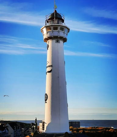
1834. Active; focal plane 37 m (121 ft); white light, 5 s on, 5 s off; red light is shown over a sector along the shore to the north. 28 m (92 ft) round brick tower with lantern and gallery, rising from a 1-story masonry building; the watch room has been expanded to a large 16-sided observation room. Tower painted white; lantern and observation room painted gray. A 2021 photo is at right, Nijhuis has a page for the lighthouse, Detienne also has a page, Trabas has a fine closeup photo by Capt. Peter, Werning also has a good photo, Wikimedia has numerous photos, Bernd Brinkmann has a 2021 photo, and Google has a street view and a satellite view. Huelse has a postcard view showing the daymark screens added to the lighthouse in 1873 and removed in 1915. In Forand's 1922 postcard view the screens had been removed. The lighthouse was built as a memorial to Jan C. J. van Speijk (or van Speyk), a Dutch naval lieutenant who died when he blew up his own gunship to prevent it from falling into the hands of Belgian revolutionaries at Antwerp in 1831. Lighthouses were present here in the 18th century but the early history of the station is unclear. Located on the seaside boulevard at the foot of Van Speijkstraat in Egmond aan Zee, about 20 km (13 mi) north of IJmuiden. Site open, tower open by appointment. . ARLHS NET-007; NL-1476; Admiralty B0842; NGA List 9864.

J.C.J. van Speijk Light, Egmond aan Zee, December 2021
Instagram photo by elleseverts

Den Helder Lighthouses

Den Helder is the municipality at the north end of the Noord Holland peninsula and the home port of the Dutch Navy. The lighthouses here are associated with the Zeegat van Texel, the historic entrance to the Zuiderzee between Den Helder and the island of Texel.
 
* Zanddijk (Julianadorp, Grote Kaap) (3)
1985 (station established 1871). Active; focal plane 31 m (102 ft); directional light, white, red, or green depending on direction, occulting once every 10 s. 17 m (56 ft) round cylindrical steel tower with lantern and gallery, painted orange-red with a darker band at the base; lantern painted white. A photo is at right, Detienne also has a page for the lighthouse, the Anke/Jens site has a fine photo, Trabas has a Capt. Peter's closeup, and Google has a street view and a satellite view. The first (1871) and second (1966) lighthouses served as the rear lights of a range, but the front light was demolished when the new lighthouse with a directional light was installed in 1985. Located on the North Sea dike about 15 km (9 mi) southwest of Den Helder, marking the approach to the Zeegat van Texel. Accessible by road; parking is available 300 m (0.2 mi) to the north. Site open, tower closed. . ARLHS NET-077; NL-1482; Admiralty B0849: NGA 9876.
* Huisduinen (Torentje) (3)
1948 (station established at least by 1864). Inactive since 2020. 18 m (59 ft) 5-story square brick building built as a channel traffic control tower. The control room on the top floor is surrounded by a gallery. Tower is unpainted red brick; control room level painted white. Nijhuis has a page for the lighthouse, Werning has a nice photo with Lange Jaap in the background, a 2021 closeup is available, and Google has a street view and a satellite view. The first lighthouse here served as a front range light for Lange Jaap. In 1900 it was replaced by the Schulpengat rear light on a skeletal tower. The present tower is open for overnight accommodations. Located in the village of Huisduinen, just west of Den Helder. Site open, tower open only to paying guests. Site manager: Het Torentje. . ARLHS NET-005; ex-NL-1492; ex-Admiralty B0856: NGA 9880.
* Kijkduin (Den Helder, "Lange Jaap (Long Jacob)") (2)
1877 (Quirinus Harder). Station established 1822. Active; focal plane 57 m (187 ft); four white flashes, separated by 3.1 s, every 20 s. 63.5 m (208 ft) 16-sided cast iron tower with lantern and gallery, painted red; lantern painted white with a red dome. 1st order Fresnel lens in use. Rotating radar antenna mounted atop the lantern. A 2021 photo appears at the top of this page, Nijhuis has a page for the lighthouse, Detienne also has a page, Wikipedia has an article on the lighthouse, Trabas has a closeup photo by Capt. Peter, Werning has a photo, Marinas.com has aerial photos, Huelse has a historic postcard view, and Google has a 2023 street view and a satellite view. The lighthouse also serves as the rear light of an outbound (westbound) range; the front light is a post on the Nieuwediep Breakwater. One of the world's great lighthouses, this was the tallest Dutch lighthouse until the Maasvlakte lighthouse was built at Rotterdam in 1974. It is the tallest enclosed cast iron lighthouse in the world. Prefabricated by Penn & Bauduin in Dordrecht. The lighthouse was closed to the public in 1998 due to safety concerns. In 1999 it was restored and registered as a national monument. In 2021 new cracks in the tower alarmed engineers and an area surrounding the tower was closed. The Rijkswaterstaat is determined to preserve the lighthouse and has enginners studying the problem. The original lighthouse was a 22 m (72 ft) brick tower. Located in Huisduinen, just west of Den Helder. Site open; due to safety concerns the tower has been closed to tours since 1998. . ARLHS NET-051; NL-1494; Admiralty B0858; NGA 9884.

Zanddijk Light, Den Helder, June 2018
Google Maps photo by Hubert P.
* [Kijkduin (Lange Jaap) (2) lantern]
1878. The shell of the former lantern of the second Kijkduin lighthouse was removed in 1992 for display out of doors in the royal dockyard of Willemsoord in Den Helder. Nijhuis has a page for the lantern and Google has a street view and a satellite view. Site open.
*** Lichtschip 10 Texel
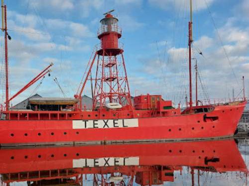
1952. Decommissioned 1994. 39 m (128 ft) steel lightship, the light displayed from a square pyramidal skeletal tower with lantern and gallery amidships. Entire vessel painted red. A 2023 photo is at right, the Lighthouse Association has a page for the ship, Nijhuis has a page, Peter Kok has a good 2008 photo, a 2021 photo is available, and Google has a street view and a satellite view. Built by Rijkswerf Willemsoord in Den Helder, this ship served most of its career on the Texel station off the Zeegat van Texel entrance, with a few assignments to other stations. It was converted to an automated lightfloat in 1976. Since 1995 it has been moored in Den Helder as a museum. Volunteers have been working to restore the ship to its appearance before the automation. Located at Weststraat 1 on the Den Helder waterfront. Site open, vessel open several days per week during the warmer months; check locally for the schedule. Site manager: Stichting Museumhaven Willemsoord (Lightschip Texel ). ARLHS NET-016.
* Lichtschip 11 Texel (light tower)
1953 (Rijkswerf Willemsoord, Den Helder). 45 m (148 ft) steel lightship. The ship served for many years on the Goeree station but it was transferred to Texel in 1988. In January 1991 it was swept ashore by a powerful winter storm and broke up on the dike. The square pyramidal skeletal light tower, with lantern and gallery, were salvaged and are displayed onshore near Lichtschip 10 (previous entry). The light tower is at the left in the photo at right, the Lighthouse Association has a page for the light tower, Nijhuis has a page, Detienne has a page, and Google has a good street view and a satellite view. Located at Weststraat 1 on the Den Helder waterfront. Site open, tower closed. Site manager: Stichting Museumhaven Willemsoord.

Lightship Texel, Den Helder, January 2023
Google Maps photo by WADIBIG

Texel Lighthouses
Texel (pronounced "Tessel" in Dutch but "Teksel" in Frisian and English) is the largest and southernmost of the Dutch Frisian islands. It is the only one included in the province of Noord Holland because it was part of the mainland until a storm in 1170 broke open the Zeegat van Texel. The island is about 20 km (13 mi) long and 8 km (5 mi) wide, and it has a permanent population of more than 13,000. Texel is readily accessible by ferry from Den Helder, and another ferry connects the north end of the island to Vlieland, the next island in the Frisian chain (see below under Lighthouses of Friesland).

*
Licht van Troost (Schilbolsnol) (3)
1977 (station established 1872). Active; focal plane 28 m (92 ft); continuous directional light, white, red or green depending on direction. 21 m (69 ft) steel mast topped by a small lantern and gallery. Entire structure painted green. Roy Barhorst's 2019 photo is at right, Trabas has a closeup photo by Capt. Peter, Nijhuis has a page for the lighthouse, and Google has a 2021 street view and a satellite view. This is a leading light for vessels entering the Zeegat van Texel. The light was nicknamed 't Licht van Troost (Troost's Light) after three generations of early keepers named Troost. In 2019 its name was changed officially to Licht van Troost. The first light was on a 7 m (23 ft) tower; it was replaced in 1912 by a 22 m (72 ft) steel tower. The 1912 lighthouse was demolished in 1977, but its lantern was saved for display at Oudeschild (see below). Located 2 km (1.2 mi) west northwest of 't Horntje. Site open, tower closed. ARLHS NET-066; NL-1496; Admiralty B0859; NGA 9952.
* Den Hoorn (ex-Schulpengat Range Rear)
1966. Active; white light occulting once every 8 s, day and night, visible only on the range line to the south southwest. Square brick church tower with the range light mounted on the gallery (balustrade), at the base of the steeple. The church is unpainted red brick, tower painted white. Trabas has a good photo by Capt. Peter, Nijhuis has a page for the lighthouse, Gerard Stolk has a 2007 photo, and Google has a 2020 street view and a satellite view. The array of three locomotive-style lamps seen in Stolk's photo has been replaced by a modern range light. This is a leading light for vessels approaching the Zeegat van Texel. The church tower is believed to date from about 1450. Located on the north side of the village of Den Hoorn. Site open, church open Tuesday through Thursday, 11 am to 4 pm; tower closed. ARLHS NET-035; NL-1488; Admiralty B0852.1; NGA 9948.
 

Licht van Troost, Texel September 2019
Instagram photo by Roy Barhorst
 
* [Schilbolsnol (2) (lantern)]
1902 (relocated to Schilbolsnol in 1956). Inactive since 1977. Round cast iron lantern with a conical roof, painted red, displayed on a short square wood skeletal tower. Michel Sjollema has a drone view, Nijhuis has a page for the lantern, Ronald Molegraaf has a street view, and the lantern is centered in a Google satellite view. This lantern was originally mounted on the former Emden Kaap lighthouse of Rottumeroog, an island in the mouth of the Ems River at the Dutch-German border. In 1956 it was transferred to the 1912 Schilbolsnol lighthouse near 't Horntje, the seaport at the southern end of the island of Texel. When that lighthouse was replaced in 1977 the lantern was donated to the Shipwreck and Beachcombing Museum in Den Burg, where it is on display outside the museum. The museum also has a lantern from the IJmuiden North Breakwater lighthouse. Site open. Owner/site manager: Schipbreuk en Juttersmuseum Flora.
**** Eierland (Texel) (2)
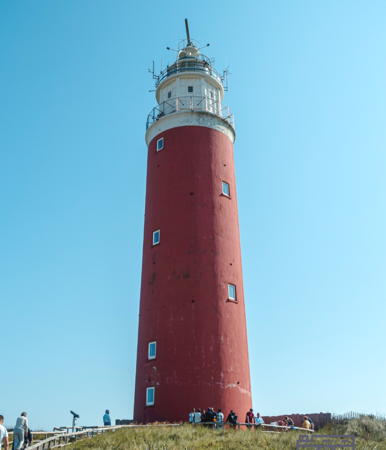
1864 (extensively rebuilt in 1948-49). Active; focal plane 53 m (174 ft); two white flashes, separated by 2.3 s, every 10 s. 35 m (114 ft) round cylindrical brick tower with lantern and gallery, painted red; lantern and watch room painted white. 3rd order Fresnel lens in use. Kevin Kooijman's 2024 photo is at right, the Rijkswaterstaat posted a 2018 photo, the Lighthouse Association has a page for the lighthouse, Nijhuis has a page, Wikipedia has an article with several photos, Trabas has a closeup photo by Capt. Peter, the Anke/Jens site also has a good photo, Marinas.com has aerial photos, and Google has a 2021 street view and a satellite view. Eierland was formerly a part of the island of Vlieland until storms made it a separate island in the 13th century. It has been joined to Texel since 1630 by construction of sea dikes. Huelse has a postcard view of the original lighthouse showing a coastguard lookout tower in front of the main tower. In April 1945 prisoners of war from Soviet Georgia seized the lighthouse during a revolt against their German captors; the Germans retook the station, severely damaging the lighthouse in the process. The lighthouse was rebuilt with a new cylindrical brick wall surrounding the damaged original. Additional restoration was carried out in 1996. For many years the lighthouse was painted a rose color; in 2004 it was repainted in the original bright red. The light station is endangered by beach erosion, which has been controlled by a sea wall. Located at the north end of the island of Texel, marking the Engelschmangat, the inlet between Texel and Vlieland. Accessible by road; Texel is accessible by ferry from Den Helder. Site open, tower open daily April through October and usually open Wednesday, Saturday and Sunday the rest of the year (may be closed for short periods in midwinter). Site manager: Vuurtoren Texel . ARLHS NET-024; NL-2064; Admiralty B0886; NGA 9960.
* [Kaap Oosterend]
1854. Daybeacon, never lit. Approx. 15 m (49 ft) hexagonal pyramidal skeletal tower, painted black. Claudia de Jong has a photo, the Lighthouse Association has a page for the beacon, Nijhuis also has a page, Ruben Gommers has a street view, and Google has a satellite view. This elegant design is by Quirinus Harder. The beacon was restored in 2010 by the municipal government. Located on a headland at Oosterend, on the east side of Texel. Site open, tower closed.

Eierland Light, Texel, September 2024
Instagram photo by Kevin Kooijman

Hollands Kroon Lighthouses
Hollands Kroon (Holland's Crown) is a municipality at the northern end of the Noord-Holland mainland created in 2012 by merging Wieringen with three other municipalities. The merged town faces north on the bay of the Amsteldiep and northeast on the IJsselmeer.

* Den Oever (Wieringen) (2) (relocated)
1885 (A.C. van Loo) (relocated 1930, 1932, and 2017; Den Oever station established 1918). Inactive since 2009. 16 m (52 ft) hexagonal pyramidal cast iron skeletal tower with lantern and gallery; access to the lantern is by a stairway that spirals up through the skeletal framework. Entire lighthouse painted red, except the ventilator ball and windvane on the top are white. A 2020 photo is at right, Nijhuis has a page for the lighthouse, a 2021 photo is available, Andre Boon has a 2022 photo, and Google has a satellite view. Historically, Wieringen was an island on the south side of the entrance to the Zuiderzee. Technically it is still an island, separated from the mainland by the Amsteldiepkanaal. The lighthouse of Den Oever, at the eastern end of Wieringen, has a complex history. Originally it was located near the western end of the island and served as the rear light of a range guiding vessels toward the Zuiderzee. Huelse has a postcard view of the lighthouse in its original location. In 1930, after the great dike called the Afsluitdijk closed off the mouth of the Zuiderzee and created the IJsselmeer, the lighthouse was relocated to stand at the south end of the dike and on the north side of the the Stevin lock that admits ocean-going ships to the IJsselmeer. Initially the lighthouse faced outward, toward the Waddenzee, but in 1932 it was moved 70 m (230 ft) south and turned so that it faces the IJsselmeer. Larry Myhre has a 2008 photo of the lighthouse in this position, Werning has a photo, and the Anke/Jens site has a good photo. The light was deactivated in April 2009. In 2016 the municipality of Den Oever requested that the lighthouse be moved to a location in the harbor, and Dutch Army engineers carried out this relocation in March 2017. The lighthouse is now located at the end of the Oostkade pier on the south side of the IJsselmeer entrance. Site open, tower closed. . ARLHS NET-006; ex-NL-1584; ex-Admiralty B0879.
* Zeughoek (2)
1969 (station established 1930). Inactive since 2009. 14 m (46 ft) square unpainted steel skeletal tower with gallery. Nijhuis has a page for the lighthouse, Waymarking.com has a photo, Andreas Köhler has a photo, and Google has a street view and a satellite view. There was an earlier (1918) lighthouse at Den Oever, seen in a postcard view posted by Forand and a second postcard view posted by Huelse; this lighthouse was moved in 1930 to Zeughoek. The old and severely deteriorated tower was replaced in 1969 by a tower of the same design, but without a lantern. Located on a headland about 7 km (4 mi) southeast of Den Oever. Site open, tower closed. ex-NL-1604.

Den Oever Light, Hollands Kroon, June 2020
Instagram photo by lighthouse.pixel •

Medemblik Lighthouse
* Medemblik Oosterhaven (replica)
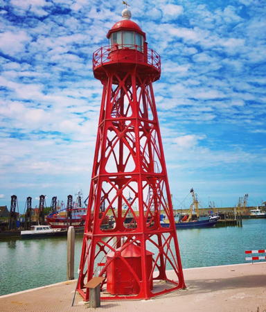
2005 (station established 1641). Active; focal plane 15 m (49 ft); white light occulting once every 5 s. 14 m (46 ft) wood post with quadrupod bracing, painted black. Benches surround the base of the tower. Trabas has Klaus Potschien's photo, Nijhuis has a page for the beacon, Harry Kool has a 2011 closeup, and Google has a street view and a satellite view. This light replicates many historic lights of the past. The light was built in 2005 following a proposal by the town's historical foundation, the Stichting Stadsherstel Medemblik. Located on the north side of the entrance to the harbor of Medemblik, a historic town about 10 km (6 mi) west of Enkhuizen. Site open, tower closed. Owner/site manager: Gemeente Medemblik. NL-1606; Admiralty B0877.9.

Enkhuizen Lighthouses
Enkhuizen is a historic port on the west coast of the IJsselmeer. Today it is mostly a recreational harbor with a large marina.
* De Ven (Enkhuizen) (2)
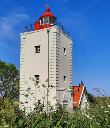
1700. Reactivated (briefly inactive in 2009); focal plane about 18 m (59 ft); white light, 2.5 s on, 7.5 s off. 15 m (50 ft) square cylindrical brick tower with lantern, attached to 1-1/2 story keeper's house. Tower painted white, lantern red. A 2023 photo is at right, Nijhuis has a page for the lighthouse, Detienne has a page, the Anke/Jens site has a photo, Werning has a good photo, Marinas.com has aerial photos, Huelse has a historic postcard view, Forand has a photo from the 1930s, and Google has a 2023 street view and a satellite view. There was an earlier lighthouse, but its date of construction is unknown. The present tower is the only survivor of three identical towers built about 1700 to guide ships through what was then the Zuiderzee to Amsterdam. The tower was repaired after being gutted by fire in 1819. A lantern was added in 1834 and a Fresnel lens the following year. It was listed as a national monument in 1966. The light was deactivated in April 2009; after numerous protests it was reactivated in October, although without its former red sector light. Located on a prominent bend in the west coast of the IJsselmeer about 6 km (3.5 mi) north of Enkhuizen. Site open, tower closed. . ARLHS NET-003; NL-1618.

De Ven Light, Enkhuizen, May 2023
Instagram photo by Wandelingen in
* Enkhuizen (Range Rear) (3?)
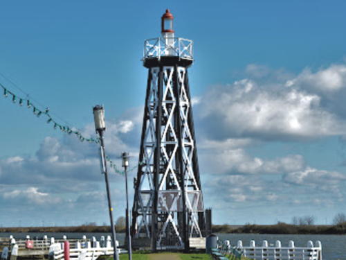
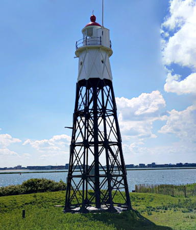
1888 (station established before 1859). Deactivated in 1932, but a decorative light is displayed and in recent years a continuous red light has been displayed from a leg on one side of the tower at a focal plane of 6.5 m (21 ft). 14 m (46 ft) octagonal pyramidal cast iron skeletal tower with gallery and a small lantern. Tower painted with black legs and gallery and white cross-members. Andre Boon's 2023 photo is at right, Nijhuis has a page for the lighthouse, Werning has an excellent photo, Wikimedia has a closeup, Rudy Muller has a photo, a 2017 twilight closeup shows the active light, Huelse has a historic postcard view, and Google has a street view and a good satellite view. This old lightbeacon is well known and often visited. Located at the end of the south breakwater at the entrance to the old harbor of Enkhuizen. Site open, tower closed. Owner/site manager: unknown. . ARLHS NET-037; modern light: NL-1626.5.

Hoorn Lighthouse
* Hoorn West Havendam
1977 (station established in the 1600s). Active; focal plane 15 m (49 ft); white light, 2 s on, 2 s off. 14.5 m (47 ft) wood post with quadrupod bracing, painted black. Nijhuis has a page for the beacon, Detienne has a page, Ilse Baay has a 2022 closeup photo, Borislav Angelov has a street view and Google has a satellite view. An engraving shows a somewhat similar light in the mid 1600s. Located at the end of the west breakwater at Hoorn, a town on the Markermeer about 20 km (13 mi) southwest of Enkhuizen. The Dutch explorer Willem Schouten named South America's Cape Horn for this village in 1616. Site open, tower closed. Owner/site manager: unknown. NL-1658.

Enkhuizen Light, Enkhuizen, February 2023
Google Maps photo by Andre Boon

Edam-Volendam Lighthouse
* Volendam
1934(?). Active; focal plane 9 m (30 ft); white flash every 5 s, shown only to the southeast through the narrow harbor entrance. Square wooden cupola with a pyramidal roof, mounted on the roof of a waterfront building. Cupola painted white, roof red. Luca Lupi has a photo and Google has a street view and a satellite view. Volendam is a port on the Markermeer, the southwestern arm of the IJsselmeer, about 32 km (20 mi) northeast of Amsterdam. The building is the Visafslag, built as a fish auction house in 1934. Today the building is a place for local artisans to sell their products. Site open, building open Tuesday through Thursday, April through November, tower closed. Owner/site manager: Village of Volendam. ARLHS NET-188; NL-1674


Waterland Lighthouses
* Lightship 9 Terschellingerbank (light tower)
1933. Inactive since 1979 (a decorative light is displayed). Approx. 10 m (33 ft) square skeletal tower with lantern and gallery, painted red. Lightphotos.net has Andreas Köhler's photo, another photo is available, Nijhuis has a page for the tower, and Google has a satellite view. The light tower of the Terschellingerbank was removed when the ship was decommissioned. The tower was restored in 2002. The hull of the ship is moored, in poor condiion, at Walsoorden in South Holland (see the Southern Netherlands page). Located on the waterfront in Monnickendam, a large recreational harbor just off the Gouwzee, the protected bay behind the island of Marken southwest of Volendam. Site open, tower closed. Site manager: unknown.
* Marken (2) (lantern)
1901. Inactive since 1992. Cylindrical cast iron lantern, painted white with a red dome. Nijhuis has a page for the lantern, Detienne has a page, Daniël de Wit has a street view, and Google has a second street view and a satellite view. This is the lantern mounted on the 1839 Marken Light in 1901 and replaced in 1992. It has been restored and is on display on the waterfront of Marken, on the west side of the island of the same name. Site open, tower closed. Site manager: unknown.
* Marken (Paard van Marken) (2)
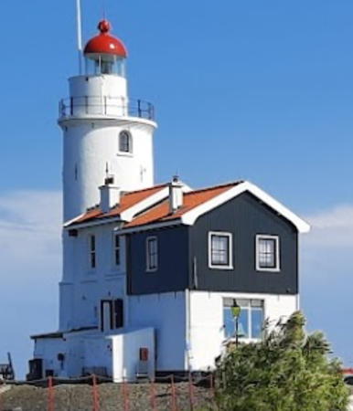
1839 (J. Valk). Station established 1700. Active; focal plane 16 m (53 ft); white light occulting once every 8 s. 15.5 m (51 ft) round brick tower with lantern and gallery, attached to a 2-story keeper's house. Lighthouse painted white; lantern dome is red. A 2023 photo by Jan Abels is at right, Nijhuis has a page for the lighthouse, Detienne has a page, Axel Seidel has a 2019 photo, the Anke/Jens site has a photo, Marinas.com has aerial photos, Huelse has a historic postcard view, Daniël de Wit has a street view, and Google has a satellite view. Because of its profile as seen from a distance the lighthouse is traditionally called het paard van Marken (the horse of Marken). The original lighthouse was one of the siblings of De Ven Light. In the winter, northeast winds funnel ice down the Markermeer toward the lighthouse, sometimes endangering the buildings; the original keeper's house was destroyed by ice in 1879, the present keeper's house was heavily damaged in 1900, and in 1971 ice reached the roof of the keeper's house. The lantern was replaced in 1992 and the fog horn was deactivated in 2001. Currently the house is occupied by Jullie Willen, the marriage registrar for Waterland, Edam, and Volendam. She meets with couples at the house to help arrange their weddings, and sometimes the weddings are held at the lighthouse. The lighthouse was under restoration in 2021, as seen in Marco Frijlink's photo. Located at the eastern tip of the island of Marken, in the Markermeer about 30 km (19 mi) northeast of Amsterdam. The island is accessible by a causeway. Site open; tower normally closed. Site manager: Trouwen Zoals Jullie Willen. . ARLHS NET-017; NL-1684.

Marken Light, Waterland, May 2023
Google Maps photo by Jan Abels

Amsterdam Lighthouses
Hoek van 't IJ (2)
1893 (A.C. van Loo) (station established 1700). Officially inactive 2003-04 and since 2006 but possibly still showing an unofficial light (we need current information!); previously listed with focal plane 18 m (59 ft); red or white light depending on direction, 3 s on, 2 s off. 19.5 m (64 ft) octagonal skeletal tower with enclosed watch room, lantern and gallery. Skeletal tower painted black, lantern and watchroom white; lantern dome is red. Rudy Linden has the 2019 street view seen at right, Nijhuis has a page for the lighthouse, Werning has a photo, Trabas has a distant view, a 2020 closeup is available, and Google has a satellite view. The IJ (Het IJ or 't IJ in Dutch) is the traditional harbor of Amsterdam, located at the southwestern corner of the former Zuiderzee, now the Markermeer. The original lighthouse here was one of the siblings of De Ven Light. The historic 1893 light was prefabricated in Leiden by Nederlandse Grofsmederij. Declared a national monument in 1981, it was deactivated in September 2003 but put back in service the following year. Recognized as a UNESCO World Heritage Site, the station has been transferred to the Staatsbosbeheer, a land preservation and management agency. In 2011 the agency issued a request for proposals to restore the buildings (cost estimated between €1 and 2 million) and propose commercial use of the island while maintaining its status as a monument. A restaurant has opened and a boutique hotel is planned. Restoration of the historic buildings on the island was to start in 2016, and Linden's street view at right shows the lighthouse nicely restored. An article on the history of the lighthouse has drawings of the original tower. Located on Vuurtoreneiland (Lighthouse Island), an island off the point (the Hoek 't IJ) at the northern entrance to the harbor, near Durgerdam. Accessible only by boat (ferry service is available for restaurant customers). Site and tower closed, but visible easily from the mainland. Owner/site manager: Staatsbosbeheer. . ARLHS NET-010; ex-NL-1710; ex-Admiralty B0835.
* [Blauwe Hoofd (Blue Head)]
1949. Inactive daybeacon, charted by Navionics. Approx. 6 m (20 ft) square unpainted brick tower. Google has a street view and a satellite view. This beacon marks the north side of the entrance to Amsterdam's inner harbor from the IJ. Located off the Durgerdammerdijk on the southeast side of Amsterdam; a bikeway passes the beacon. Site open, tower closed.

Hoek van t'IJ Light, Amsterdam, June 2019
Google Maps photo by Rudy Linden
Trinity House Lightship 12 Amsterdam
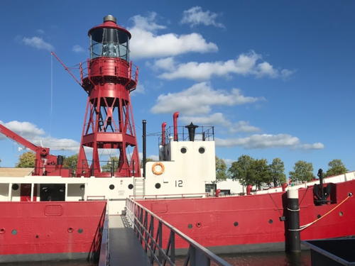
1952. Decommissioned 1988. 41.2 m (137 ft) steel lightship; light displayed from a square pyramidal steel skeletal tower with lantern and gallery. Built by Philip & Son, Dartmouth, England. The ship served many stations off the English coast in the service of Trinity House. After passing through several owners the ship found its way to Amsterdam, where Iris Klempau found it moored at Grasweg 53-82 in good condition. For a time there were reported to be plans to convert it to a museum. However, Anna Jenšíková found no evidence of such a conversion when she visited the ship in June 2007. In July 2008 the ship was purchased by Jeff De Wolf. According to Klempau, as of July 2014 the ship was moored in the Johan van Hasseltkanaal-West just west of the Ridderspoorweg bridge. Lena Levin has a 2016 photo of the ship there. In 2019 the ship was at the Mariadistel quay and was listed for sale; the ship is seen at that location in Google's April 2019 street view. In 2020 the ship opened as an upscale bed and breakfast. A 2022 photo by Enho Enho Lepurks is at right, Nijhuis has a page for the ship, Detienne has a page, and Google has a 2023 street view and a satellite view. Site and vessel closed. Owner/site manager: Lightship Amsterdam . ARLHS NET-160.
* Zaamdam Hoge (Range Rear)
1886. Inactive since 1997. Approx. 22 m (72 ft) slender square iron skeletal tower mounted on a large square brick base and carrying a triangular daymark. Tower painted white, base black. Google has a street view and a satellite view. The front light was on a mast. Located on the Houthavenkade waterfront in the Zaadam neighborhood of Amsterdam. Site open, tower closed.

Trinity House Lightship 12, Amsterdam, October 2022
Google Maps photo by Enho Lepurks

Muiden Lightship
German Lightship Noorderlicht (ex-Flensburg)
1910. Decommissioned 1963. 46 m (151 ft) steel lightship, since converted to a 2-masted schooner. Hull painted red. Originally rigged with 3 masts, the ship served on the Kalkgrund shoal off the entrance to the Flensburg Fjord on Germany's Baltic coast. Wikimedia has Holger Ellgaard's 1961 photo of the ship on station. After being decommissioned it served for a number of years as a dormitory for workers on the Flensburg waterfront. Later it was used as a club ship for a yacht club. In 1992, by then a rusty hulk, it was rescued by Ted van Broeckhuysen and Gert Ritzema. Converted to a schooner, it is used for adventure cruises to Svalbard and other destinations in the Arctic. Photos are available. Muiden is its base. Owner/operator: AdventureSmith Explorations (Noorderlicht).

Notable faux lighthouses:

Information available on lost lighthouses:

Adjoining pages: East and North: Northeastern Netherlands | South: South Holland

Return to the Lighthouse Directory index | Ratings key

Posted January 23, 2005. Checked and revised February 12, 2025. Lighthouses: 24; lightships: 4. Site copyright 2025 Russ Rowlett and the University of North Carolina at Chapel Hill.