Lighthouses of the Netherlands: Zeeland

The Kingdom of The Netherlands (Nederland in Dutch) is located on the southeast side of the North Sea and has a population of about 18 million. A small country with a long and illustrious maritime tradition, the Netherlands is home to a large number of historic lighthouses. For centuries fires were lit atop brick towers to guide returning Dutch sailors, and even today the traditional Dutch word for a lighthouse is vuurtoren (fire tower).

The Netherlands is divided into twelve provinces (provincies), and the provinces are subdivided into municipalities (gemeenten). This page includes lighthouses of the southern part of the country, all but one in the province of Zeeland and one in the neighboring province of Noord-Brabant, This region includes the mouths of two of the great rivers of northwestern Europe: the Schelde and the Maas (Meuse).

There is strong interest in the country in lighthouses and their preservation and many towers have been restored in recent years.

Lighthouses in the Netherlands are maintained by the Rijkswaterstaat, the ministry of infrastructure and water management. In recent years there has been a movement to transfer some of the historic towers to the ownership of municipal authorities.

The digraph IJ or ij acts as an additional letter in the Dutch alphabet. In Dutch vuurtoren is a lighthouse, lage licht is a front light, hoge licht is a rear light, lichthuis is a lantern room, lichtopstand is a smaller light beacon, baken is an unlit beacon, eiland is an island, ondiepte is a shoal or reef, baai is a bay, zeestraat is a strait, zeegat is an estuary or harbor mouth, kaap is a cape or headland, sluis is a lock, dijk is a dike, rivier is a river, and haven is a harbor.

ARLHS numbers are from the ARLHS World List of Lights. NL numbers are from the official Dutch list. U.K. Admiralty numbers are from volume B of the Admiralty List of Lights & Fog Signals. U.S. NGA numbers are from Publication 114.
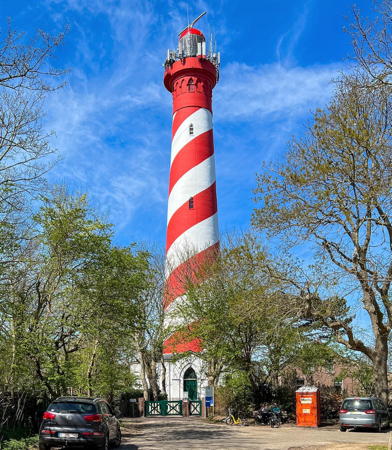

West Schouwen Light, Haamstede, April 2022
ex-Instagram photo by nttawwt
General Sources
Nederlandse Vuurtoren Vereniging
Web site of the Netherlands Lighthouse Association. The site includes an interactive map leading to information about each lighthouse.
Online List of Lights - Netherlands
Photos by various photographers posted by Alexander Trabas. Many photos are by Capt. Peter Mosselberger ("Capt. Peter").
Leuchttürmseiten von Anke und Jens - Netherlands
This site has photos and information on many of the lights.
Leuchttürme.net - Niederlande
Photos and text posted by Malte Werning.
Les Sentinelles des Mers - Pays-Bas
Photos and information by Guy Detienne.
Netherlands Lighthouses
Excellent aerial photos posted by Marinas.com.
Lighthouses of the Netherlands
Excellent photos by Marc de Kleijn, including larger versions of his photos shown on this page.
Nederlandse Vuurtorens
Excellent photos and lighthoiuse information by Dennis Nijhuis.
Phares d'Europe
Photos posted by Alain Guyomard and Robert Carceller, including about 20 Dutch (Pays-Bas) lighthouses.
Lighthouses in the Netherlands
Photos by various photographers available from Wikimedia.
World of Lighthouses - Netherlands
Photos by various photographers available on Lightphotos.net.
List of Lights for the Dutch Coast and Adjacent Areas
The official Dutch light list is available for download.
Netherlands
Historic postcard views posted by Michel Forand.
Holländische Leuchttürme und Feuerschiffe auf historischen Postkarten
Historic postcard views posted by Klaus Huelse.
GPSNavigationCharts
Navigation chart information for the Netherlands.

Kaapduinen Range Rear Light, Veere, April 2023
Google Maps photo by Da Zi

Lighthouses of Zeeland (Zealand)

Zeeland is the province in the southwestern corner of the Netherlands, incorporating much of the complicated delta of the Scheldt and Maas Rivers. The name of the province is sometimes spelled Zealand in English, but that risks confusion as Zealand is also used as the English name of the Danish island of Sjælland. The Dutch would like everyone to know that the nation of New Zealand, halfway around the world, was discovered for Europeans by the Dutch explorer Abel Tasman in 1642 and is named for Zeeland, not Sjælland.

Sluis Lighthouses

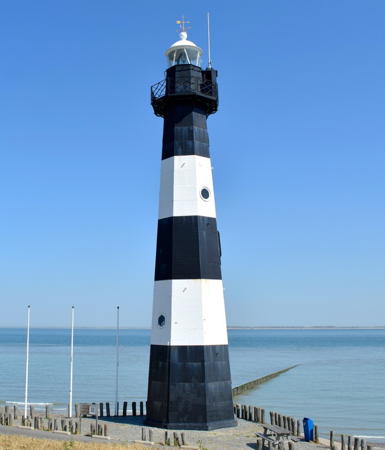
*** Nieuwe Sluis (Breskens, Wielingen) (Range Rear)
1868 (Quirinus Harder). Reactivated (inactive 2011-2016, now privately maintained); focal plane 28 m (92 ft); white light occulting once every 10 s. 22 m (72 ft) octagonal cast iron tower with lantern and gallery, painted with black and white horizontal bands; lantern is black with a white roof. A 2024 photo is at right, Detienne also has a page for the lighthouse, Cees Wouda has a good photo, Werning has a good photo, Trabas has a photo, Christian Becker has a 2023 photo, Marinas.com has aerial photos, Huelse has a historic postcard view, Forand has a postcard photo from the 1960s, Peter Van den Wyngaert has a street view from the beach, and Google has a satellite view. This is one of twelve lighthouses designed by the engineer Quirinus Harder (1801-1880). Prefabricated by L.I. Enthoven & Co. of Den Haag, it served as the rear light of a range for many years. The former front range light (next entry) has been relocated to Breskens. Painted with camouflage patterns during World War II, it survived Allied bombing runs. The lighthouse was listed as a national monument in 1982. It was officially deactivated in October 2011 and apparently reactivated sometime in 2016. Located atop the dike at the end of the Panoramaweg in Nieuwe Sluis, west of Breskens, marking the southern entrance to the Westerschelde estuary. Site open, tower open on weekends April through October and also on Fridays in July and August. Site manager: Vuurtoren Breskens . ARLHS NET-018; NL-0046; Admiralty B0166.1; NGA 9118 (ex-9120).
* Nieuwe Sluis (Breskens) Range Front (2) (relocated)
1906 (station established 1868). Inactive since 1940. Approx. 10 m (33 ft) hexagonal skeletal tower with lantern and gallery, painted black; lantern roof painted white. Detienne also has a page for the lighthouse, Pascal Van Acker has a closeup photo, Werning has a photo, and Google has a street view and a satellite view. In 1978 the lighthouse was relocated for display in Breskens at the entrance to the Fishery Museum. Located on the Grote Kade in downtown Breskens. Site open, tower closed. Owner/site manager: Visserijmuseum Breskens. ARLHS NET-183M; ex-Admiralty B0166; ex-NGA 9116.

Terneuzen Lighthouses
Braakmanhaven (Leading) (2?)
Date unknown. Active; focal plane about 33 m (108 ft); continuous light, white, red or green depending on direction. 30 m (98 ft) skeletal tower. Trabas has a photo and Google has a satellite view. This leading light replaces a former pair of shorter range lights; the old range rear light is at lower left in Trabas's photo. Since 2012 NGA has described the light as being on a steel mast. Located at the Braakmanhaven container port on the south side of the Westerschelde a short distance west of Terneuzen. Site and tower closed. NL-0121; Admiralty B0233.4; NGA 9240.

Nieuwe Sluis Light, Breskens, August 2023
Instagram photo by BezoekWestZeeuwsVlaanderen
* Nieuw Neuzenpolder (Outer Dyke) Range Rear (2)
1955. Active; focal plane 16 m (52 ft); white light, 4 s on, 1 s off. 13 m (43 ft) square skeletal tower, painted with green and white horizontal bands. Trabas has a photo, and Google has a satellite view. The front light is on a short post. The range guides vessels on a southeastward reach in the Westerschelde. The original light was shown through a window of the keeper's house. Located beside the Nieuw Neuzenweg on the south side of the Westerschelde just west of the Westerschelde Tunnel. Site open, tower closed. NL-0126.1; Admiralty B0236.1; NGA 9252.
* [Terneuzen Vestpier (2?)]
Date unknown (station established in the 1860s). Active; focal plane about 12 m (39 ft); contiuous white or green light depending on direction. 7.5 m (25 ft) concrete mast painte wit green and white horizontal bands. Trabas has Capt. Peter's photo, a 2022 photo is available, and Google has a satellite view. Huelse has a postcard view of the original light, a hexagonal skeletal tower; it survived until it was removed as unsafe in 1992. Located on the west pier of the Veerhaven in Terneuzen. Accessible by walking the pier. Site open, tower closed. NL-0154; Admiralty B0245; NGA 9272.
* Terneuzen Veerhaven (2)
1992. Active; focal plane 15 m (49 ft); red, white, or green light depending on direction, 3 s on, 2 s off. 10 m (33 ft) slender round cylindrical tower with lantern and gallery, painted with black and white horizontal bands. Trabas has a good photo by Capt. Peter Mosselberger, Reginald Verlinden has a street view, and Google has a satellite view. This leading light guides both eastbound and westbound vessels in the Westerschelde. Located on the west jetty of the Veerhaven in Terneuzen. Accessible by walking the pier. Site open, tower closed. ARLHS NET-121; NL-0152; Admiralty B0244; NGA 9280.

Hulst Lightship
Lichtschip 9 Terschellingerbank
1933. Decommissioned 1979. 42.6 m (140 ft) steel lightship. Light tower removed. Endangered. The ship is in terrible condition in Google's May 2024 street view. Frank Behrends has a closeup photo, Lightphotos.net also has a photo, Huelse has a historic postcard view of the ship in service, and Google has a satellite view. Built at the Royal Willemsoord dockyard in Den Helder, this ship served its entire career on the Terschellingerbank station off the island of Terschelling. The ship was sunk by a British air raid during World War II, but it was raised and repaired and returned to service in 1948. After decommissioning the light tower was removed; it has been on display ever since at the yacht harbor in Monnickendam, north of Amsterdam (see the Northern Netherlands page). The hull has been moored in the harbor at Walsoorden, on the south side of the Westerschelde about 25 km (15 mi) northeast of Terneuzen. In 2003 Iris Klempau found the ship "all alone" as if abandoned. Information is needed on its current ownership. Site status unknown. ARLHS NET-023.

Reimerswaal Lighthouse
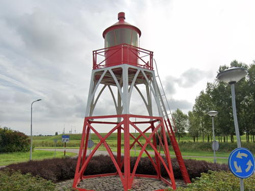
* Hansweert (1) (relocated)
1914. Inactive since 1992. 8 m (26 ft) hexagonal skeletal tower with lantern and gallery, painted red with a white horizontal band. Google's 2022 street view is at right, a closeup photo is available, and Google also has a satellite view. This light originally stood on the west side of the Zuid-Beveland Canal in Hansweert, a town on the north side of the Westerschelde about 15 km (9 mi) southeast of Goes. The light marked the lock entrance. Disassembled in 1992 when it was replaced by a modern light, the light was rebuilt the following year in a traffic roundabout on the Kanaalweg, not far from the original location. Site open, tower closed. Site manager: unknown. ARLHS NET-089.

Hansweert Light, Reimerswaal, September 2022
Google Maps street view

Borsele Lighthouse
* [Hoedekenskerke]
1914. Active; focal plane 6 m (20 ft); white, red or green light, depending on direction, occulting once every 9 s. 5 m (17 ft) square cylindrical brick tower, painted white (formerly red with one white horizontal band). A 2019 photo is available, Trabas has Capt. Peter's closeup photo, and Google has a satellite view. Located on the bend of a breakwater sheltering a small boat harbor at Hoedekenskerke. Site open, tower closed. Operator/site manager: unknown. NL-0168; Admiralty B0268; NGA 9300.

Vlissingen Lighthouses
Van Cittershaven Entrance
Date unknown. Active; focal plane about 30 m (98 ft); continuous light, white, red or green depending on direction. Approx. 27 m (89 ft) triangular skeletal mast. Trabas has a photo and Google has a satellite view. The light guides vessels entering a petroleum terminal at Sloehaven on the east side of Vlissingen. Located at the east end of the harbor. Site and tower closed. NL-0095; Admiralty B0206.5; NGA 9214.
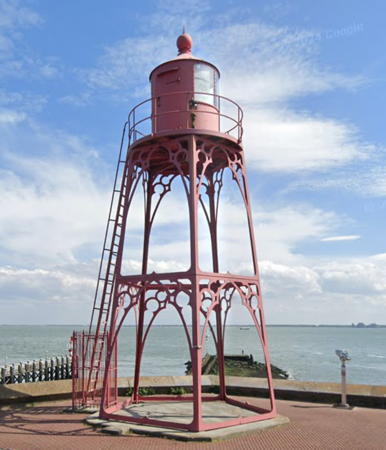
* Vlissingen (2)
1990 replica of 1891 lighthouse. Active; focal plane 15 m (49 ft); white, red or green light, depending on direction, 1.5 s on, 1.5 s off. 11 m (36 ft) pentagonal pyramidal cast iron tower with lantern and gallery. Entire structure painted bright red. Google's 2024 street view is at right, Detienne also has a page for the lighthouse, Trabas has Tom Chisholm's closeup photo, another closeup is available, Werning has a good photo, Huelse has a historic postcard view, Forand has another historic postcard view, and Google also has a satellite view. The pentagonal form of this lighthouse is unusual; in addition, its light displays no less than 14 sectors. The original lighthouse was removed in 1989 due to its advanced deterioration; the present lighthouse is a copy. Located on the west mole, marking the entrance to the old commercial harbor (Koopmanshaven) of Vlissingen (Flushing). Site open, tower closed. . ARLHS NET-073; NL-0072; Admiralty B0200; NGA 9168.

Veere Lighthouses
* Kaapduinen Range Rear (2)
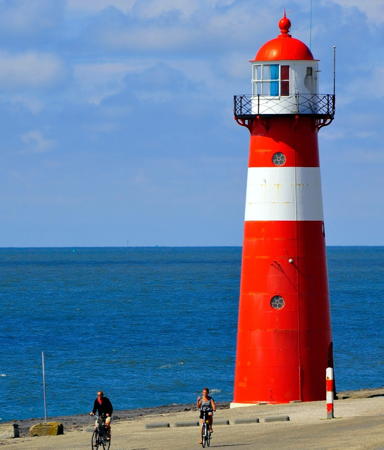
1951 (station established 1866). Active; focal plane 35 m (115 ft); white light occulting once every 5 s, synchronized with the rear light. 13 m (43 ft) square yellow brick tower with a pyramidal roof; the light is shown through a large square window near the top of the tower. Tower painted with horizontal red bands. A 2023 photo is at the top of this page, Trabas has Capt. Peter's closeup photo, Werning has a fine photo, Wikimedia has a photo of both Kaapduinen lights, Em. Klocki has a sea view showing both lights (this one is on the right), Detienne has a page for the range lights, Huelse has a historic postcard view, Jonna van Hesteren has a distant street view from the beach, and Google has a satellite view. This is the rear light of an range guiding ships southbound toward the Westerschelde in a channel close to the beach. Located 220 m (240 yd) southeast of the front light, about 8 km (5 mi) northwest of Vlissingen. Accessible from the village of Dishoek walking the path to the beach. Site open, tower closed. ARLHS NET-049; NL-0062; Admiralty B0184.1; NGA 9160.

Vlissingen Light, Vlissingen, June 2024
Google Maps street view
* Kaapduinen Range Front (2)
1951 (station established 1866). Active; focal plane 26 m (85 ft); white light occulting once every 5 s, synchronized with the rear light. 14 m (46 ft) square yellow brick tower with a pyramidal roof; the light is shown through a large square window near the top of the tower. Tower painted with horizontal red bands. Trabas has Capt. Peter's closeup photo, Werning has a photo, Henk Kerkhof has a 2017 photo, Wikimedia has a photo of both Kaapduinen lights, Em. Klocki has a sea view showing both lights (this one is on the left), Detienne has a page for the range lights, Huelse has a historic postcard view, and Google has a satellite view. Located just off the beach on the north side of the Westerschelde, about 8 km (5 mi) northwest of Vlissingen. Accessible from the village of Dishoek walking the path to the beach. Site open, tower closed. ARLHS NET-048; NL-0060; Admiralty B0184; NGA 9156.
* Zoutelande (Range Front) (2)
1951 (station established 1866). Active; focal plane 21 m (69 ft); continuous white light visible only along the range line. 13 m (43 ft) square red brick tower with a pyramidal roof; the light is shown through a large square window near the top of the tower. Trabas has a closeup photo by Capt. Peter, Detienne has a page for the lighthouse, Anke and Jens also have a page, Werning also has a photo, Amy van Wijk has a 2021 photo, Andre Boon has a 2023 photo, Forand has a postcard photo from the 1950s, and Google has a drone view and a satellite view. This directional light guides ships northbound in the channel close to the beach. The Westkapelle High Light was formerly considered the rear light of this range. Located atop the dike on the north shore of the Westerschelde in Zoutelande, about 8 km (5 mi) southwest of Westkapelle. Site open, tower closed. ARLHS NET-034; NL-0056; Admiralty B0174.1; NGA 9152.
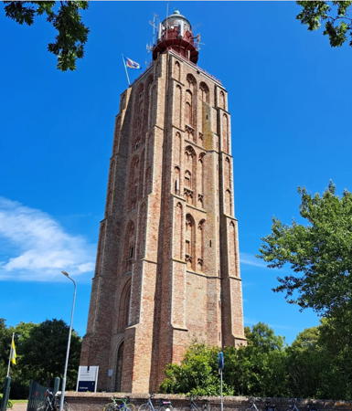
*** Westkapelle High (Walcheren, ’t Hoge Licht) (Range Rear) (2)
1906 (station established 1818). Active; focal plane 49 m (161 ft); white flash every 3 s. 52 m (171 ft) tower, including approx. 12 m (39 ft) round cast iron tower with lantern and gallery atop a 40 m (131 ft) square brick church tower. Church tower unpainted; cast iron tower painted bright red; lantern dome is unpainted metallic green. 3rd order Fresnel lens (1951) in use. A 2023 photo by Joke Mylanus is at right, Detienne has a page for the lighthouse, Trabas has a closeup photo by Capt. Peter, Werning has a good photo, Bart van Andel has a 2021 photo, Wikimedia has a 2017 photo by W. Bulach, a drone view is available, Huelse has a historic postcard view, Forand has a postcard photo from 1952, and Google has a street view and a good satellite view. The church tower was built between about 1458 and 1470. The Noorderhooft and Zoutelande towers were placed so that they work with the high light as ranges. The Sint-Willibrordskerk, except for the tower, burned in 1831, and since then the tower has served solely as a lighthouse. Huelse also has a view of the tower as it appeared before 1906. Listed as a national historic landmark in 1966. The cast iron light tower was restored in 2004. In 2015 volunteers began working to restore the interior of the building, and in May 2016 the tower was opened as a museum with art exhibitions on the first floor and lighthouse history exhibits on upper floors. Located at the west end of the Zuidstraat in Westkapelle, 1.3 km (3/4 mi) southeast of the low light. Site open; museum open (limited hours) Tuesday, Wednesday, Thursday and Saturday April through October and on holiday Mondays during the winter. Site manager: Vuurtoren Westkapelle. . ARLHS NET-030; NL-0054; Admiralty B0174; NGA 9144.

Westkapelle High Light, Westkapelle, July 2023
Instagram photo by Joke Mylanus
** Noorderhoofd (Westkapelle Low, ‘t Lage Licht) (Range Front)
1876 (Quirinus Harder and Nering Bogel). Active; focal plane 18 m (59 ft); red, white, or green light depending on direction, 7 s on, 3 s off. 16 m (52 ft) round cast iron tower with lantern and gallery, painted red with a white horizontal band; lantern is white with a red dome.A 2023 photo is at right, Trabas has a closeup photo by Capt. Peter, Detienne has a page for the lighthouse, Werning has a good photo, Anke/Jens's has a June 2004 photo, Marc de Kleijn has a good photo, Huelse has a historic postcard view, Forand has a 1963 postcard photo, and Google has a street view and a good satellite view. Prefabricated by Nering Bögel, Deventer. This light with the Westkapelle light forms an approach range to the channel along the shoreline approaching the Westerschelde; the red and green sectors warn nearby ships away from shoals to the south. Located just behind the sea dike at Westkapelle, at the western tip of Walcheren, marking the northern entrance to the Westerschelde. Site open, tower open regularly (inquire at Polderhuis Westkapelle for the schedule). . ARLHS NET-031; NL-0052; Admiralty B0173.9; NGA 9140.
** Veere (1)
1847. Inactive since 1924. Approx. 18 m (56 ft) medieval stone tower with a sharply pointed roof; the light was shown from a balcony at a focal plane of 11.5 m (38 ft). Anke and Jens have a page for the lighthouse, Maurice de Beijer has a street view, Huelse has a historic postcard view, Forand has a postcard view from 1920s, and Google has a satellite view and a street view from the rear of the building. This tower, the Campveerse Toren, was built in the late 14th century; it is now in use as an inn and restaurant. The light guided ships on the Veerse Meer, the former channel separating Walcheren from Noord Beveland; this channel is now closed at both ends to form a brackish lake. In front of the building is the active light (focal plane 9 m (30 ft); flash every 6 s, white, red or green depending on direction) on a 7 m (23 ft) mast atop a small equipment enclosure. Located at the entrance to the small boat harbor in Veere, near the northern end of the Walcheren Kanal. Site open, tower open to guests of the inn. Owner/site manager: De Campveerse Toren . ARLHS NET-200. Active light: NL-0620.

Schouwen-Duiveland Lighthouses
Formerly two islands, Schouwen-Duiveland is one of the large islands in the delta of the Maas and Rhine rivers, lying between the Oosterschelde on the south and the Grevelingen on the north.
 

Noorderhoofd Light, Westkapelle, May 2023
Instagram photo by uitkijktorens.nl
* [Plompe Toren]
1468. Inactive daybeacon, charted by Navionics. 23 m (75 ft) 2-stage brick tower, the lower 2/3 square and the upper third octagonal. Dutch Wikipedia has an article with a photo, Ria Overbeeke has a closeup photo, and Google has a street view and a satellite view. Built as the tower of church, this tower is the only building remaining of the village of Koudekerke; the village was gradually lost to erosion during the 17th century. The tower has served ever since as a leading beacon for ships in the Oosterschelde; the channel is close to the bank in this area. The tower has been restored several times, most recently in 1974. It serves now as a museum and visitor center. Located on the north shore of the Oosterschelde about 8 km (5 mi) east of the mouth.Site open, tower open when the museum is open. Operator: Natuurmonumenten (Plompe Toren).
* [West Schouwen lantern]
1882. 6 m (20 ft) round lantern, somewhat modified but at least the dome appears original. Lantern painted white with a red dome. This lantern was removed from the West Schouwen Light in 1979 and relocated to Burghsluis, where it served for a time as the harbormaster's office. Eveline Wijnstekers has a 2018 photo, Jean Renier has a second photo, Werning has a photo, Detienne has a page for the lantern, and Google has a satellite view. Located on the waterfront of Burghsluis, a town on the north side of the Oosterschelde about 6 km (4 mi) southeast of the lighthouse. Site open; lantern may also be open. Owner/site manager: unknown.
* West Schouwen (Westerlichttoren, Haamstede)
1840 (L. Valk). Active; focal plane 57 m (187 ft); three white flashes every 15 s, the first two separated by 2.4 s and the others by 6 s. 50 m (164 ft) round brick tower with lantern and gallery, painted in a red and white spiral ("barber pole") pattern; watch room, lantern, and gallery painted red. 2nd order Fresnel lens in use. A 2022 photo appears at the top of the page, Detienne has a page for the lighthouse, Trabas has a closeup photo by Capt. Peter, Werning has a photo, Huelse has a historic postcard view, Peter de Blieck has a panoramic view from the gallery, and Google has a street view and a satellite view. We are fortunate that this classic lighthouse escaped destruction during World War II. The lantern was replaced in 1979 and the old lantern is now on display at the harbormaster's office in Burghsluis. A major restoration began in 2018 and was still in progress in the fall of 2020, with the tower wrapped in scaffolding. Located in the village of Nieuw Haamstede near the westernmost point of Schouwen-Duiveland. Accessible by road, but parking is limited. Site open, tower closed. . ARLHS NET-029; NL-0324; Admiralty B0500; NGA 9576.
Verklikker (2)
1949 (station established 1912). Inactive since 1996. 4 m (13 ft) round cylindrical white concrete tower with what appears to be a brick section at the top. The Lighthouse Society has a page for the lighthouse, Nijhuis has a closeup photo, and Google has a satellite view. Forand has a postcard view of the original lighthouse, a skeletal tower with lantern and gallery. Located in a dune field just north of Nieuw Haamstede. Site and tower closed there is a view from the Verklikkerpad. ARLHS NET-201; ex-Admiralty B0502.

Lighthouses of Noord Brabant (North Brabant)

Moerdijk Lighthouse
* Willemstad (2)
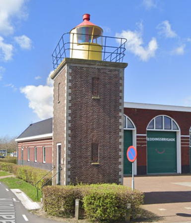
1947 (station established 1820). Inactive since 1989. 10 m (33 ft) square cylindrical brick tower with lantern and gallery, unpainted; lantern painted yellow with a red conical roof. Google's 2023 street view is at right, Theodora Atje has a 2021 photo, John Caddell has photos, Werning has a good photo, the Anke/Jens site has a nice closeup photo, Detienne has a page for the lighthouse, Wikimedia has a good photo, Huelse has a historic postcard view, and Google also has an indistinct satellite view. Huelse also has a postcard view of the original lighthouse, an interesting pentagonal cast iron skeletal tower; Forand has another postcard view. The old tower was destroyed during World War II. Located on the Lantaarndijk on the waterfront of Willemstad, overlooking the Hollands Diep, a segment of the lower Maas east of the junction of the Haringvliet and Brouwershaven, the estuaries north and south of Goeree-Overflakkee; Willemstad is off exit 23 of the A29 freeway south of Rotterdam. Site open, tower open occasionally (inquire locally). ARLHS NET-075; ex-Admiralty B0577.

Willemstad Light, Willemstad, April 2023
Google Maps street view

Information available on lost lighthouses:

Notable faux lighthouses:

Adjoining pages: North: South Holland | South: Belgium

Return to the Lighthouse Directory index | Ratings key

Posted January 23, 2005. Checked and revised January 30, 2025. Lighthouses: 18; lightships: 3. Site copyright 2025 Russ Rowlett and the University of North Carolina at Chapel Hill.