Lighthouses of New Zealand: Southwest South Island

New Zealand is an independent island nation in the southwestern corner of the Pacific Ocean. Its location is remote, roughly 1500 km (900 mi) southeast of Australia and 1000 km (600 mi) south of New Caledonia and Fiji. Settled in the 13th Century by a Polynesian people known as the Māori, it was colonized by Great Britain in 1840. It has been part of the British Empire and then the British Commonwealth ever since. It is a Commonwealth realm, recognizing the British monarch as head of state. New Zealand has a population of about 5.1 million.

New Zealand is larger than many Northern Hemisphere residents might suppose: roughly 1600 km (1000 miles) long from north to south, stretching from the subtropical north to the cool temperate south. It includes two large islands, North Island and South Island, with many smaller islands. For local government the country is divided into sixteen regions, including eleven regional council areas and five unitary council areas. The regional council areas are subdivided into districts. This page describes lighthouses of the south and west coasts of South Island, including the regional council areas of Otago, Southland, and West Coast.

Most of the coastline of New Zealand is high and scenic. Many of the lighthouses are at remote locations, and lighthouse fans need a good pair of hiking shoes to reach some of them, if they can be reached at all.

Coastal lighthouses are operated and maintained by Maritime New Zealand. Information on most of these lighthouses is readily available on the MNZ web site. Harbor lighthouses, however, are owned and maintained by local harbor authorities, and less information is available for most of them. There is no national lighthouse preservation group, but Heritage New Zealand has acted to preserve several lighthouses after they were deactivated.

Many of the place names in New Zealand are in the Māori language; the Māori phrase for a lighthouse is whare rama or whare tūrama; motu is an island, toka is a rock, and whanga is a harbor.

ARLHS numbers are from the ARLHS World List of Lights. Admiralty numbers are from Volume K of the Admiralty List of Lights & Fog Signals. U.S. NGA light list numbers are from NGA Publication 111.


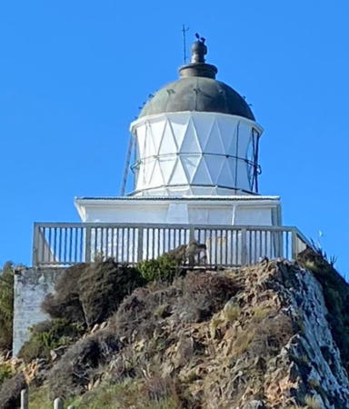
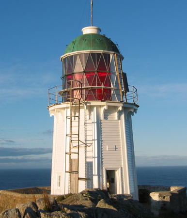
Katiki Point (Moeraki) Light, Otago, December 2023
Instagram photo by Rachel Melcher
General Sources
Maritime New Zealand - Lighthouses
Information available on Maritime New Zealand's lighthouse site.
List of Lights
Official light lists posted by Land Information New Zealand.
Encyclopedia of New Zealand - Lighthouses
An excellent historical account by Helen Beaglehole.
Lighthouses of Foveaux Strait - a History
(pdf file) A 144 page report by Angela Bain, published by the N.Z. Department of Conservation.
New Zealand Lighthouses
Data and photos posted by Kevin Mulcahy of Lighthouses.net.au.
World of Lighthouses - New Zealand
Photos by various photographers available from Lightphotos.net.
Lighthouses in New Zealand
Photos by various photographers available from Wikimedia Commons.
New Zealand Lighthouses
Photos taken in 2017 by Larry Myhre.
Online List of Lights - New Zealand - South Island East Coast and West Coast
Photos by various photographers posted by Alexander Trabas. Many photos for South Island are by Michael Boucher or Rainer Arndt.
Leuchttürme.net - Neuseeland
Photos and data posted by Malte Werning.
Leuchttürme Australiens und Ozeaniens auf historischen Postkarten
Historic postcard views posted by Klaus Huelse.
GPSNavigationCharts
Navigation chart information for New Zealand.

Otago Region (Southeast Coast) Lighthouses

Waitaki District (Oamaru Area) Lighthouses
Oamaru Breakwater
Date unknown. Active; focal plane 8 m (26 ft); red flash every 5 s. 7 m (23 ft) square skeletal tower painted white. Trabas has Boucher's photo, Peter Kurdulija has a 2020 photo, Jane Thompson has a view from the sea, and Google has an indistinct satellite view. Located at the end of the east breakwater at Oamaru, a seaport of about 14,000 residents sheltered by Cape Wanbrow. Site status unknown. Operator: Waitaki District Council (Oamaru Harbour). Admiralty K4348; NGA 5358.
* Cape Wanbrow (2)
1944 (station established 1874). Inactive. Approx. 3 m (10 ft) square lantern room, originally painted white, set in the side of a bluff. Werning has a good photo and Google has a satellite view. The structure looks more like an observation post than a lighthouse, and in fact it was built as part of an artillery installation in 1943. Abandoned and open to the elements. Located in the Cape Wanbrow Reserve on the south side of Oamaru; accessible by a short hike on the Silver Hill Trail from King George Park. Site and lantern room open. Site manager: Waitaki District Council (Cape Wanbrow Reserve). ARLHS NZL-015.

North Otago District Lighthouse
* Katiki Point (Moeraki)
1878. Active; focal plane 58 m (190 ft); white light, 6 s on, 6 s off. 8.5 m (28 ft) hexagonal wood tower with lantern and gallery, painted white with red trim; lantern painted black. Rachel Melcher's 2023 photo is at the top of this page, Trabas has Boucher's photo, Marilou Scott has a 2017 closeup photo, Kat Brinsley has a 2015 photo, Werning has a page with a fine photo, Wikimedia has several excellent photos, Patrick Uhle has a street view, and Google has a satellite view. The original Fresnel lens remains in place but in 2005 the light was moved to an LED lens unit mounted on the gallery. Located at the end of Lighthouse Road in Moeraki Township, about 25 km (15 mi) south of Oamaru. Parking available. Site open, tower closed. Operator/site manager: Maritime New Zealand. . ARLHS NZL-034; Admiralty K4360; NGA 5368.

Dunedin City Lighthouses
Dunedin is the second largest city of South Island with a population of about 135,000. The city is built around the head of Otago Harbour, a natural harbor formed as a long inlet of the sea. The Otago Peninsula is a long finger of land between the south shore of Otago Harbour and the ocean.

*
Heyward Point
Date unknown. Active; focal plane 25 m (82 ft); flash every 5 s, white or red depending on direction. 4 m (13 ft) round white tower. No photo available but Google has a satellite view. Located on a steep headland about 2 km (1.25 mi) northwest of the Otago Harbour entrance. Accessible by hiking the Heyward Point Track. Site open, tower closed. Operator: Port Otago Ltd. Site manager: N.Z. Department of Conservation (Heyward Point Scenic Reserve). Admiralty K4362; NGA 5384.
Otago Approach Channel
Date unknown. Active; focal plane 19 m (62 ft); continuous light, white, red or green depending on direction. 5 m (16 ft) square tower carrying large red daymarks in the form of arrows pointing up. Myhre has a photo, Trabas has Darlene Chisholm's photo, and Google has an indistinct satellite view. This is a leading light for the channel entering Otago Harbour. Located on a bluff on the south side of the entrance to the Harbour. Site status unknown. Operator/site manager: Port Otago Ltd. Admiralty K4366; NGA 5392.
* Taiaroa Head
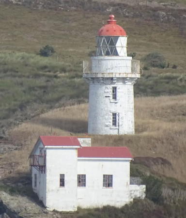
1865 (Hugh Calder). Active; focal plane 60 m (197 ft); two long (2 s) white flashes every 18 s. 12 m (39 ft) round stone tower with lantern and gallery, painted white; lantern roof is red. 1-story signal building painted white with a red roof. Lyndon Allen's 2023 photo is at right, Nicholas Thompson has a good photo, Trabas has Boucher's closeup, Katja Schulz has a 2018 photo, Lightphotos.net has Karl Agre's photo, and Google has a satellite view and a distant street view. The area surrounding the lighthouse is a nature reserve, the site of a large nesting colony of royal albatross. (This is the only place in the world where albatross nest near civilization.) Located at the northeastern tip of the Otago Peninsula about 32 km (20 mi) northeast of Dunedin, marking the entrance to Otago Harbour. Parking provided. Site and tower closed, but the lighthouse can be seen from albatross viewing platforms (viewing is closed during the nesting season from mid September to late November). Operator: Port Otago Ltd. Site manager: N.Z. Department of Conservation and Royal Albatross Centre. . ARLHS NZL-049; Admiralty K4364; NGA 5396.

Taiaroa Head Light, Otago, February 2023
Instagram photo by Lyndon Allen
[Cape Saunders (5)]
2006 (station established 1865). Active; focal plane 55 m (180 ft); white light, 2 s on, 8 s off. 3 m (10 ft) square aluminum cabinet, painted white. Two 1-story brick keeper's houses. A photo is available, Wikimedia has a distant view, and Google has a satellite view. Huelse has a historic postcard view of the 1880 lighthouse, a hexagonal wood tower similar to the Katiki and Akaroa lighthouses. In 1948 a lantern was relocated here from Kaipara North Head (see Northern North Island); it was mounted on the wooden tower until 1954, then on a steel skeletal tower until 1967, then on the ground on a concrete pad. Mulcahy has a photo of the lantern and a photo (fifth photo on the page) taken in 2001 shows the keeper's houses and the lantern on the ground. In 2006 the lantern was replaced by the modern beacon and the keepers houses have also been removed. The lantern was restored and is now on display at the Otago Peninsula Museum in Portobello; Google has a street view and a satellite view. Located on the southeastern tip of the cape about 25 km (15 mi) east of Dunedin. Accessible by a dirt road (4WD recommended) and fairly popular as a hiking destination. Site open, tower closed. Operator/site manager: Maritime New Zealand. ARLHS NZL-014; Admiralty K4376; NGA 5404.

Clutha District Lighthouse
* Nugget Point
1870. Active; focal plane 76 m (250 ft); white light, 2 s on, 2 s off, 2 s on, 6 s off. 9.5 m (31 ft) round cylindrical stone tower with lantern and gallery, attached to 1-story equipment building. Vivian Sia's 2023 photo is at right, Rian Long has a photo, Trabas has Boucher's closeup, Wikimedia has several photos, Jiří Leipert has a 2014 street view, and Google has a satellite view. The original Fresnel lens remains in place but in 2006 the light was moved to an LED lens unit mounted on the gallery.The roof of the equipment building was replaced in 2016. The light station is perched spectacularly on a knife-edged ridge, but it is accessible in good weather by a hiking trail 600 m (3/8 mi) long. Yellow-eyed penguins are often seen on beaches below the trail. Located at the end of a gravel road near Kaka Point, about 3 km (2 mi) south of Port Molyneux. It is about a 15 minute walk to the lighthouse from the parking area. Site open, tower closed. Operator/site manager: Maritime New Zealand. . ARLHS NZL-038; Admiralty K4380; NGA 5408.

Nugget Point Light, Port Molyneux, August 2023
Instagram photo by Vivian Sia

Southland Region Lighthouses

Eastern Foveaux Strait Lighthouses
Foveaux Strait is the passage separating South Island and Stewart Island/Rakiura. The strait narrows to a minimum width of 14 km (9 mi). Rough and turbulent, it is a dangerous passage for ships.

Tautuku Peninsula
Date unknown. Active; focal plane 32 m (105 ft); three white flashes every 15 s. 4 m (13 ft) square white cylindrical steel tower. Mulcahy has a photo and Google has a fuzzy satellite view. Located on a steep headland about 50 km (30 mi) east of Slope Point. Site status unknown. ARLHS NZL-087; Admiralty K4381; NGA 5412.
* [Slope Point (2)]
2020. Active; focal plane 33 m (108 ft); white flash every 5 s. 3 m (10 ft) octagonal white metal cabinet. Zdeněk Voců has a June 2020 photo of the new light and Luana Dominey has a second photo taken in December 2020. This light replaced a round metal lantern, painted white. Toni Escuder has a photo of the previous light, Mulcahy has a photo, Steffen Illium has a 2015 street view, and Google has a satellite view. Slope Point is the southernmost point of South Island. Located on a sheep farm about 13 km (8 mi) east of Waipapa Point. This is private property but the owners allow access except during lambing season (September-November); parking is available. Site open, tower closed. ARLHS NZL-085; Admiralty K4382; NGA 5416.
** Waipapa Point
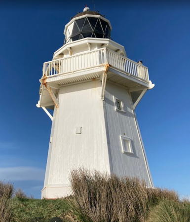
1884. Active; focal plane 21 m (70 ft); five white flashes every 20 s. 13 m (44 ft) hexagonal wood tower with lantern and gallery, painted white with red trim; lantern roof is gray. Keeper's house and all other station buildings demolished. A 2021 photo is at right, Ester Levanon has a 2018 closeup photo, Peter Lynch has another closeup, Trabas has a photo, a 2018 view is available, Daniel Schneider has a street view, and Google has a satellite view. This lighthouse was built after the steamship Tararua wrecked nearby in 1881 with the loss of 131 lives. Together with the Dog Island Light (next entry) it guides vessels through a narrow passage between South Island and Ruapuke Island at the east end of Foveaux Striat. The lighthouse was in poor condition until 2008, when Maritime New Zealand announced a restoration project. Amy Millan's January 2008 photo shows the lighthouse before restoration. Also in 2009 the Conservation Department spent $330,000 to improve parking and visitor facilities. Sibling of Akaroa Head Light. Located on the point, about 11 km (7 mi) south of NZ 92 near Otara. Site open, tower closed. Operator/site manager: Maritime New Zealand. . ARLHS NZL-056; Admiralty K4384; NGA 5420.

Waipapa Point Light, Southland, August 2021
Google Maps photo by 新西兰天舒 (New Zealand Tianshu)
Dog Island
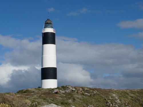
1865 (James Balfour). Active; focal plane 46 m (150 ft); white flash every 10 s. 36 m (118 ft) round concrete-clad stone tower with lantern and gallery, painted white with two black horizontal bands. Natalya Volna's photo is at right, Trabas has Boucher's photo, a 2021 photo is available, Phillip Capper has a distant view from the mainland, Huelse has a historic postcard view, and Google has a good satellite view. This is the tallest New Zealand lighthouse. The tower has had a slight lean since soon after it was built, due to poor soil conditions on the island; it was encased in concrete two feet thick in 1916 to strengthen it against this lean. This was the last staffed station in New Zealand, finally automated in 1989. Located on a low island in Foveaux Strait off the entrance to Bluff Harbour, at the southern tip of South Island. Visible from the beach at Bluff and from the Foveaux Express ferry from the Port of Bluff to Halfmoon Bay on Stewart Island. Site and tower closed. Operator/site manager: Maritime New Zealand. . ARLHS NZL-019; Admiralty K4394; NGA 5428.

Invercargill City (Bluff Harbour) Lighthouses
Invercargill is both the southernmost and westernmost city in New Zealand, and its southernmost seaport. The city has a population of about 60,000. Bluff, a town of about 1800 residents, is the port associated with Invercargill.

No. 3 Reach Range Rear
Date unknown. Active; focal plane 12 m (39 ft); white flash every 1.5 s. 12 m (39 ft) square skeletal tower, painted black, on a square platform supported by piles. Trabas has Boucher's photo and Google has a satellite view. This is the final entrance range for Bluff Harbour. the front light is on a shorter tower. Located beside the channel inside the harbor. Accessible only by boat. Site open, tower closed. Operator: South Port. Admiralty K4405.1; NGA 5464.
Dog Island Light
Dog Island Light, Foveaux Strait, December 2011
Flickr Creative Commons photo by Natalya Volna
* Stirling Point (2)
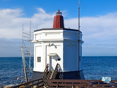
1912 (station established 1884). Active; focal plane 11 m (36 ft); continuous red light. 1-story octagonal concrete tower with a short octagonal pillar on the roof. Building painted white, pillar red. A 2023 photo is at right, Cory Stevenson has a 2019 photo, Trabas has a closeup, a 2008 photo is available, Huelse has a historic postcard view, and Google has a street view and a satellite view. This tiny but historic lighthouse is a popular attraction, along with the nearby Stirling Point Signpost. The building is an old signal station. Located at the end of Marine Parade in the East End neighborhood of Bluff, marking the west side of the entrance to the harbor. Accessible by road, but parking is very limited. Site open, tower closed. Operator: South Port. Site manager: Invercargill City Council. . Admiralty K4398; NGA 5436.
* Bluff Harbour Entrance
Date unknown. Active; focal plane 19 m (62 ft); flash every 3 s, white or red depending on direction. 6 m (20 ft) square skeletal wood tower carrying a white triangular daymark. The light is seen at 4:05 into a YouTube video and Google has a satellite view. This light replaced a lightship station established in 1879. Accessible by the Foveau Walkway, a trail connecting Stirling Point to Lookout Point in the Bluff Hill/Motupohue Scenic Reserve. Located about 1.4 km (0.9 mi) southwest of Stirling Point. Site open, tower closed. Operator: South Port. Site manager: Invercargill City Council. Admiralty K4397; NGA 5432.

Stewart Island Lighthouses
Stewart Island, also called Rakiura, is a roughly triangular island across the Foveaux Strait from South Island. It is sparsely populated with a permanent population of about 450, but it attracts vacationers in the summer. It is accessible by ferry from Bluff.

#Acker's Point (1)
Date unknown (relocated here in the early 1930s). Replaced and demolished in 2005. This was a 5 m (16 ft) square wooden tower enclosing the light; tower painted white. Mulcahy has a photo and Google has a satellite view of the point. Acker's Point is a promontory on the north side of the entrance to Halfmoon Bay, Stewart Island; the cape shelters the harbor of Oban, the only town on the island. ARLHS NZL-073.

Stirling Point Light, Bluff, April 2023
Instagram photo by 大胖纸Eric
* [Acker's Point (2)]
2005 (station established in the early 1930s). Active; focal plane 20 m (66 ft); three white flashes every 10 s; a red sector is displayed east northeast to warn ships away from crashing into the point. 5 m (16 ft) square white tower. Yan Naing Aye has a 2022 photo, a 2020 photo is available, Bruce Liu has a photo, and David Newstead has a closeup street view. An observation platform provides excellent views of the strait. Located on the tip of the point. Accessible by a popular hiking trail. Site open, tower closed. Operator: Maritime New Zealand. Site manager: N.Z. Department of Conservation (Rakiura National Park). Admiralty K4388; NGA 5512.

Western Foveaux Strait Lighthouse
Centre Island (Raratoka Island)
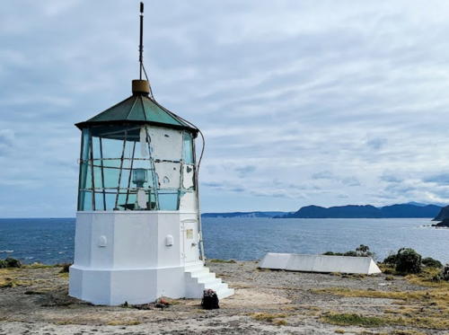
1878. Active; focal plane 81 m (265 ft); flash every 15 s, red or white depending on direction. 12 m (40 ft) octagonal wood tower with lantern and gallery, painted white with red trim; lantern roof is black. A Maritime New Zealand photo is at right, the Te Ara Encyclopedia project has a photo, a view from the sea is available, and Google has a satellite view. The original lens was replaced in the 1990s and placed in storage; in 2012 it was reassembled for display at the Bluff Maritime Museum in Bluff. The current light is a rotating solar-powered beacon. Located on the southern tip of a small island in the western entrance to Foveaux Strait. Visible distantly from beaches in the Wakapatu area, off NZ 99 about 55 km (35 miles) west of Invercargill. Site and tower closed. Operator/site manager: Maritime New Zealand. ARLHS NZL-017; Admiralty K4438; NGA List 5536.

Fiordland (Southwest Coast) Lighthouses
[Long Point]
Date unknown. Active; focal plane 23 m (75 ft); four white flashes every 15 s. 4 m (13 ft) square aluminum cabinet. Mulcahy has a photo and Google has a satellite view. Located on a headland 56 km (35 mi) east southeast of Puysegur Point. Site status unknown. Operator: Maritime New Zealand. Site manager: N.Z. Department of Conservation (Fiordland National Park). Admiralty K4440; NGA 5540.

Centre Island Light, Foveaux Strait
Maritime New Zealand photo
Puysegur Point (2)
1943. Reactivated (inactive 1980-1987); focal plane 45 m (148 ft); white flash every 12 s. 5 m (17 ft) lantern mounted on a short octagonal concrete pedestal. Gwen Nisbet's 2022 photo is at right, Trabas has James Smith's 2016 view from the sea, Mulcahy has an MNZ photo, Simon Tripe has a 2013 photo, and Google has a satellite view. The lighthouse has appeared endangered in recent years: the lantern appears in terrible condition in Rory Sherlock's 2018 photo. MNZ restored the lighthouse sometime between 2018 and 2022. The original lighthouse, a wooden tower, was burned to the ground in 1942 by a deranged gold prospector who lived nearby. The present lantern was relocated from Godley Head (see above). The light was deactivated in 1980 in favor of an automated light at Windsor Point, but it was reactivated seven years later when the Windsor Point Light was discontinued. The original Fresnel lens was replaced with a modern rotating beacon in 1996. Located in a very remote and roadless area at the southwestern tip of New Zealand. Site open but rather inaccessible, tower closed. Operator: Maritime New Zealand. Site manager: N.Z. Department of Conservation (Fiordland National Park). . ARLHS NZL-043; Admiralty K4442; NGA 5545.
Cape Providence
Date unknown. Active; focal plane 60 m (197 ft); white flash every 5 s. 4 m (13 ft) round white metal tower. Mulcahy has an MNZ photo and Google has a satellite view. Located on a remote headland on the north side of the entrance to Edwardson Sound, a deep inlet on New Zealand's Fiordland coast. Accessible only by helicopter. Site open, tower closed. Site manager: N.Z. Department of Conservation (Fiordland National Park). Admiralty K4444; NGA 5548.
Five Fingers Point
Date unknown. Active; focal plane 166 m (545 ft); three white flashes every 20 s. 9 m (30 ft) steel skeletal tower, painted white. Mulcahy has an aerial photo and Google has a distant satellite view. Located on a remote headland of New Zealand's Fiordland coast. Accessible only by helicopter. Site open, tower closed. Site manager: N.Z. Department of Conservation (Fiordland National Park). Admiralty K4446; NGA 5552.

Puysegur Point Light, Southland, March 2022
Google Maps photo by Gwen Nisbet

St. Anne Point
1937. Active; focal plane 27 m (88 ft); white flash every 5 s. 6 m (20 ft) white round cylindrical tower with enclosed equipment room in the base. Trabas has Boucher's 2017 photo, Mulcahy has posted a photo, Werning has a distant view, and Google has a distant satellite view. Located on a rocky point at the southern entrance to Milford Sound, one of the many deep fjords of New Zealand's southwest coast. Accessible only by boat. Site and tower closed. Operator: Maritime New Zealand. Site manager: N.Z. Department of Conservation (Fiordland National Park). ARLHS NZL-062; Admiralty K4464; NGA 5560.

West Coast Region Lighthouses

The West Coast Region is wild and remote. Steady onshore winds bring rain and wild surf and the Southern Alps mountains rise steeply behind the shore. The population of the region is less than 35,000. Hokitika, Greymouth, and Westport are the only towns of any size.

Westland District Lighthouses
[Jackson Head]
Date unknown. Active; focal plane 155 m (509 ft); two quick white flashes every 15 s. 4 m (13 ft) square white metal tower. Google has a distant satellite view. Located atop a very steep headland sheltering the fishing village of Jackson Bay, the southernmost settlement of the West Coast Region. Quite remote, but probably accessible by hiking from the village. Site open, tower closed. ARLHS NZL-067; Admiralty K4466; NGA List 5564.
* Hokitika
1879 (John Blackett). Inactive since 1925. 5.5 m (18 ft) square wood tower with lantern but no gallery, painted white with dark green trim. The current lantern is a replica; the original lantern, removed when the lighthouse was deactivated, is now mounted on the Kaipara North Head lighthouse (see the North Island page). Kieran Isherwood's 2021 photo is at right, Kerry Kissane has a 2009 photo, Francis Vallance has a closeup photo, Sergi Balaguer has a good photo, and Google has a 2019 street view and a satellite view. Slated for demolition, the lighthouse was saved instead as an observation tower. Later abandoned, it was in very poor condition until Heritage Hokitika restored it in 1999. The replica lantern was added in 2002, and the group hopes to reactivate the light as a private aid to navigation in the future. Located on a hilltop above Fitzherbert Street (NZ 6) on the north side of Hokitika, a town of about 3000 residents that is the administrative seat of the West Coast Region. Site open, tower closed. Owner: uncertain. Site manager: Heritage Hokitika . ARLHS NZL-027.

Hokitika Light, Southland, January 2021
Google Maps photo by Kieran Isherwood


Grey District Lighthouse
* Greymouth Range Front
Date unknown. Active; focal plane 14 m (46 ft); continuos light, green or red depending on direction. 14 m (46 ft) triangular skeletal tower carrying a large slatted daymark painted yellow with a red vertical stripe. Trabas has Thomas Philipp's photo and Google has a street view and an indistinct satellite view. Greymouth is the largest town of the West Coast Region with a population of about 8300. Located on the quay on the south side of the Grey River. Site open, tower closed. Operator: Port of Greymouth. Admiralty K4475; NGA List 5588.
* Greymouth Range Rear
Date unknown. Active; focal plane 19 m (62 ft); continuous green light. 19 m (62 ft) triangular skeletal tower carrying a large slatted daymark painted white. Trabas has Boucher's photo and Google has a street view and an indistinct satellite view. Located on the quay on the south side of the Grey River, 160 m (525 ft) southeast of the front light. Site open, tower closed. Operator: Port of Greymouth. Admiralty K4475.1; NGA List 5592.

Buller District Lighthouses
* Cape Foulwind (2)
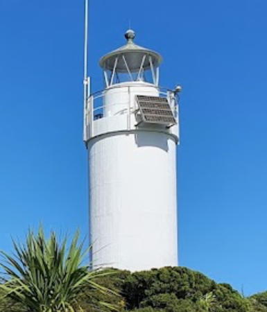
1926 (station established 1876). Active; focal plane 70 m (230 ft); white flash every 12 s. 9 m (30 ft) round cylindrical concrete tower with lantern and gallery, painted white. The Fresnel lens has been removed from the lantern and the active light is an LED beacon mounted on the gallery rail. Randy Khoo Waisheng has the 2021 photo seen at right, Trabas has Thomas Philipp's photo, Wikimedia has Andy King's 2011 photo, Werning has a page with a good photo, another photo is available, and Google has a street view and a satellite view. The lighthouse replaced a hexagonal wooden tower seen in Huelse's postcard view; the foundations of that tower and of the original keeper's houses are visible. The original lantern was relocated to Kaipara North Head on North Island in 1948. The beach at the cape is well known for its seal colony. Located at the end of Lighthouse Road west of the village of Cape Foulwind and about 11 km (7 mi) west of Westport, beyond the end of NZ 67A; accessible by a walk of about 800 m (1/2 mi) from the parking area. Site open, tower closed. Operator/site manager: Maritime New Zealand. . ARLHS NZL-008; Admiralty K4486; NGA List 5600.
* Westport (Buller River)
Date unknown (station established 1886). Active; focal plane 20 m (66 ft); white flash every 5 s. Approx. 16 m (52 ft) skeletal tower mounted atop a square concrete World War II observation tower. Lighthouse painted white with one red horizontal band at the top of the concrete building. Trabas has Boucher's closeup photo and Google has a closeup street view and a satellite view. Located on the west breakwater at the entrance to the Buller River, which forms the harbor of Westport, about 250 m (800 ft) from the end of the breakwater. Site open, tower closed. Operator: Westport Harbour. Admiralty K4490; NGA List 5608.

Cape Foulwind Light, Westport, April 2021
Google Maps photo by Randy Khoo Waisheng

Information available on lost lighthouses:

Notable faux lighthouses:

Adjoining page: North: Northeast South Island

Return to the Lighthouse Directory index | Ratings key

Posted April 2, 2004. Checked and revised January 2, 2025. Lighthouses: 25. Site copyright 2025 Russ Rowlett and the University of North Carolina at Chapel Hill.