Lighthouses of the Philippines: Northern Mindanao

The Republic of the Philippines (Pilipinas in Filipino) includes more than 7600 islands stretching over 1750 km (1100 mi) of the western Pacific and separating the Philippine Sea on the east from the South China Sea on the west. The largest islands are Luzon at the northern end of the country and Mindanao at the southern end. As of 2020 the population of the country was about 109 million.

The archipelago was a Spanish colony until the Spanish-American War of 1898, which brought the islands under U.S. administration. Japan occupied the islands during World War II (1942-45) and the country became independent shortly thereafter (1946).

Mindanao, the second largest island of the Philippines, occupies the southern end of the archipelago. The island is very irregular in shape; the largest portion is very roughly elliptical extending northeast to southwest and there is also a long curved extension, the Zamboanga Peninsula, on the west. The small islands of the Sulu Archipelago stretch from the end of the Zamboanga Peninsula towards Borneo. The population of the island is about 27 million.

The Philippines is divided into 17 regions and subdivided into 81 provinces. This page lists lighthouses of the Northern Mindanao Region, a region traditionally known as Misamis that occupies the central third of the north coast of the island. Lighthouses of the western third of the north coast are listed on the Zamboanga and Sulu page and those of the eastern third are listed on the Caraga Region page.

Filipino and English are official languages in the Philippines. In Filipino a lighthouses is called a parola; an island is an isla or pulo. Many English maritime terms have been adopted into Filipino, including cape, bay, and port, and the names of historic lighthouses are often retained in their Spanish forms.

Lighthouses in the Philippines are maintained by the Marine Safety Services Command of the Philippine Coast Guard.

Many Philippine lighthouses are not well known so better information and photos are always needed.

ARLHS numbers are from the ARLHS World List of Lights. PCG numbers are the Philippines Light List numbers, where known. Admiralty numbers are from volume F of the Admiralty List of Lights & Fog Signals. U.S. NGA List numbers are from Publication 112.

General Sources
Lighthouses in the Philippines
Wikipedia article with links to articles on several of the individual lighthouses.
Spanish Lighthouses of the Philippines
This is the Directory's own list of the Spanish light stations, with notes on their current status.
Lighthouses in the Philippines
Photos by various photographers available from Wikimedia.
World of Lighthouses - Philippines
Photos by various photographers available from Lightphotos.net.
Online List of Lights - Philippines - Mindanao
Photos by various photographers posted by Alexander Trabas.
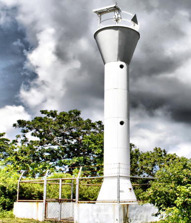

Baliangao Point Light, Baliangao, December 2008
Flickr photo by Aljune Quinones
Misamis Occidental Province Lighthouses
Misamis Occidental (Western Misamis) Province is located on the west side of Iligan Bay, a broad southwestern extension of the Bohol Sea.

*
Baliangao Point
2008 (?). Active; focal plane unknown; white flash every 7 s. 9.5 m (31 ft) round steel and fiberglass tower, flared at the top and bottom. Entire lighthouse is white. Aljune Quinones's photo is at the top of this page and Google has a fuzzy satellite view. Located on a point about 2.5 km (1.5 mi) east of Baliangao. Site open, tower closed. Admiralty F2281.3; NGA 15051.
[Plaridel (lightfloat)]
Date unknown. Active; focal plane 6 m (20 ft); red flash every 5 s. 6 m (20 ft) red post on a round base. Marlon Quimno has a 2022 photo and Bing has an indistinct satellite view. This light is near the listed location and presumably replaced a fixed light. Located off the quay marking the edge of a large shoal area at Plaridel, a town of about of about 40,000 residents on the west side of the entrance to Iligan Bay. Site open, tower closed. Admiralty F2281; NGA 15056.
Polo Point (2?)
Date unknown (station established 1911). Active; focal plane 18 m (60 ft); three white flashes every 10 s. 16 m (53 ft) round barbell-shaped white steel and fiberglass tower. Jacek Sygovia has a 2023 drone view and Google has a satellite view. The original light was described as a 12 m (38 ft) "frame structure." Located on the point about 5 km (3 mi) southeast of Plaridel, marking the western entrance to Iligan Bay. Site status unknown. ARLHS PHI-096; PCG-0362; Admiralty F2280; NGA 15064.
* Oroquieta (Oroquita)
Date unknown. Active; focal plane unknown; white light, 2 s on, 2 s off. Approx. 12 m (39 ft) round barbell-shaped steel and fiberglass tower. Entire lighthouse is white. Aljune Quinones has a closeup photo, DeeVayn Saturre has a 2021 photo, and Google has a 2021 street view and a satellite view. Located on the waterfront of the city plaza in downtown Oroquieta, on the west side of Iligan Bay. Site open, tower closed. PCG-0361; Admiralty F2278; NGA 15066.
* Tabu Point (Jimenez)
Date unknown. Active; focal plane 10 m (33 ft); white flash every 5 s. 9 m (30 ft) round barbell-shaped steel and fiberglass tower. Entire lighthouse is white. Aljune Quinones has a closeup photo and Google has a street view and a satellite view. Located on a cape about 3 km (2 mi) southeast of Jimenez. Site open, tower closed. PCG-0360; Admiralty F2276; NGA 15068.
** Misamis Point (Ozamiz)
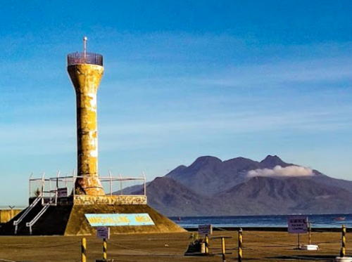
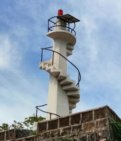
1917. Active; focal plane 17 m (55 ft); two red flashes every 10 s. 9 m (30 ft) concrete tower mounted on the eastern bastion of the historic Spanish Fort Santiago (1756), known locally as the Cotta of Misamis. The tower can be climbed by an external stairway. Ian Laput's 2017 photo is at right, Aljune Quinones has a photo, and Google has a street view and a satellite view. Ozamiz is a city of about 150,000 residents. Located on a headland at the eastern entrance to the harbor of Ozamiz, on the west side of Panguil Bay. Site and tower open. ARLHS PHI-092; PCG-0359; Admiralty F2274; NGA 15080.

Misamis Point Light, Ozamis, October 2017
Googkle Maps photo by Ian Laput

Lanao del Norte Province North Coast and Iligan City Lighthouses
Lanao del Norte spans the narrowest section of Mindanao, with a long north coast on Iligan Bay and a shorter south coast on Illana Bay. Tubod is the provincial capital. Lighthouses of the southern coast are described on the Southern Mindanao page.

*
Tubod (Panguil Bay)
Date unknown. Active; focal plane about 14 m (43 ft); green flash every 5 s. 10 m (33 ft) round barbell-shaped steel and fiberglass tower. Entire lighthouse is white. Märkräm Búdź has a photo, a view from the sea is available, and Google has a satellite view. Tubod, the capital of Lanao del Norte, is a city of about 60,000 residents. Located on the wharf at Tubod, on the east side of Panguil Bay, an inlet of Iligan Bay. Site and tower open. Site open, tower closed. Admiralty F2275; NGA 15070.
Kolambugan Range Front
Date unknown. Active; focal plane 20 m (66 ft); continuous red light. Approx. 20 m (66 ft) tower. No photo available but Google has an indistinct satellite view. This is an entrance range for Iligan Bay. Located at the village of Kolambugan on the south side of the bay opposite Ozamiz. Site status unknown. Admiralty F2270; NGA 15082.
Kolambugan Range Rear
Date unknown. Active; focal plane 23 m (75 ft); continuous red light. Listed as a 9 m (30 ft) tower. No photo available but Google has an indistinct satellite view. Google's street view shows a square skeletal tower that probably carries the light. Located 180 m (590 ft) south of the front light. Site status unknown. Admiralty F2270.1; NGA 15084.
Labuay
Date unknown. Active; focal plane about 15 m (49 ft); white flash every 5 s. Approx. 12 m (39 ft) round barbell-shaped steel and fiberglass tower. Entire lighthouse is white. No photo available and the light is not seen in Google's distant satellite view. Located on the south side of an inlet about 25 km (15 mi) northeast of Tubod. Site status unknown. PCG-0579; Admiralty F2269; NGA 15081.
* Iligan
Date unknown. Active; focal plane 11 m (36 ft); red flash every 2 s. 10 m (33 ft) tower, originally a white concrete post light with an external spiral stairway. At some point an octagonal observation room and octagonal gallery were added. Anie June Calonia's 2019 photo is at right, Jesus Joel Bado has a photo, Märkräm Búdź also has a photo, and Google has a satellite view. Iligan is a major city with a population of about 360,000; it is administered separately from the surrounding Lanao del Norte Province. Located at the south end of the wharf in Iligan. Site open, tower closed. Admiralty F2268; NGA 15088.

Iligan Light, Iligan, September 2019
Google Maps photo by Anie June Calonia

Misamis Oriental Province Lighthouse
Misamis Oriental (Eastern Misamis) Province has a long coastline facing north on the Bohol Sea. Cagayan de Oro is the provincial capital.

Salimbal Point (Lugait)
Date unknown. Active; focal plane about 15 m (49 ft); white flash every 10 s. Approx. 10 m (33 ft) round barbell-shaped white steel and fiberglass tower. Google has a satellite view and a 2016 street view (the view is blocked in more recent street views). Located on the waterfront of an industrial port at Lugait, a town of about 20,000 residents at the western border of Misamis Oriental. Site and tower closed. PCG-0730; Admiralty F2267.5; NGA 15095.
* Sulauan Point (Sulawan Point, Laguindingan)
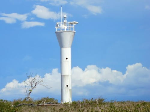
2002. Active; focal plane unknown; white flash every 10 s. 9.5 m (31 ft) round barbell-shaped steel and fiberglass tower. Entire lighthouse is white. Alex Aag has the closeup photo seen at right, Erika Kaye has a 2023 closeup, and Google has a satellite view. The lighthouse stands beside the ruins of a Spanish cotta (fort). Located on a promonotory near the Laguindingan Airport, marking the west side of the entrance to Macajalar Bay. Site open, tower closed. PCG-0619; Admiralty F2267; NGA 15094.
Opol (Molugan Point)
Date unknown. Active; focal plane 12 m (39 ft); green flash every 5 s. 11 m (36 ft) round barbell-shaped white steel and fiberglass tower. No photo available but Google has a satellite view. Opol is a traditional fishing port on Macajalar Bay; it is now a terminal for fast ferries to Jagna in Bohol and Balbagon in Camiguin, and the Philippine Ports Authority is developing a major commercial port. Located north of the ferry terminal in Opol. Site status unknown. Admiralty F2266.5; NGA 15093.

Salauan Point Light, Laguindingan, May 2013
Goiogle Maps photo by Alex Aag
* Macabalan Point (Cagayan de Oro) (2)
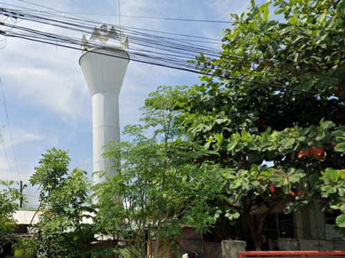
Date unknown (station established 1911). Active; focal plane 18 m (58 ft); green flash every 5 s. 16 m (53 ft) round steel and fiberglass tower, flared at the top and bottom. Entire lighthouse is white. The City of Cagayan de Oro posted a good photo and Google has the 2022 street view seen at right and a satellite view. Jazz Ramiro visited this station in 2007 and found that the original steel skeletal tower had been removed, apparently around 2001. Part of the steel framework of the tower was being used to construct a house on the site. The provincial capital of Cagayan de Oro is a large city of nearly 700,000 residents. Located on the point marking the entrance to the harbor of Cagayan de Oro. Site open. ARLHS PHI-088; PCG-0356; Admiralty F2266; NGA 15092.
Tagoloan
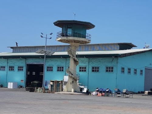
Date unknown. Active; focal plane 43 m (141 ft); white flash every 4 s. Approx. 35 m (115 ft) round harbor control tower. Google has a street view and a satellite view. Located at the Mindanao International Container Port at Tagoloan, at the southeastern corner of Macajalar Bay. Site status unknown. Admiralty F2265.5; NGA 15097.
Villanueva
Date unknown. Active (privately maintained); focal plane at least 30 m (98 ft); continuous red light. At least 30 m (98 ft) round concrete chimney painted with red and white horizontal bands. Johan C. So has a photo and Google has a street view and a satellite view. Located in a power plant about 5 km (3 mi) north of Tagaloan on the east coast of Macajalar Bay. Site and tower closed but the tower is visible over a wide area. Owner/site manager: FDC Misamis Power Corporation. Admiralty F2265; NGA 15098.
Alutaya Reef (2?)
Date unknown. Active (privately maintained); focal plane about 12 m (39 ft); red flash every 5 s. 12 m (39 ft) square 2-story concrete building supported by concrere piles. San Martin has a photo, Ebs Elberts has a sea view, and Google has a satellite view. Located on a reef about 4 km (2.5 mi) offshore and 16 km (10 mi) southwest of Balingasag. Accessible only by boat. Site open, tower closed. PCG-0332; Admiralty F2264.8; NGA 15098.5.

Macabalan Point Light, Cagayan de Oro, September 2022
Gogle Maps street view
* Balingasag (Punta Gorda)
Date unknown. Active; focal plane about 12 m (39 ft); white flash every 10 s. 9.5 m (31 ft) white round barbell-shaped tower. Google has a 2024 street view and a satellite view. Located beside the coastal highway on Punta Gorda, a headland about 10 km (6 mi) southwest of Balingasag, a city of about 75,000 residents. Site open, tower closed. PCG-0508; Admiralty F2264.5; NGA 15099.
Salay (?)
Date unknown. Active; focal plane unknown; white light, pattern unknown. No description and no photo available. Salay, a town of about 30,000 residents, has no port facilities and no traditional lighthouse has been found along its coast. The light is probably mounted somewhere on a tall communicatiown tower close to the listed light location. Google has a street view and a satellite view of the communications tower. More information needed. Site open, tower closed. Admiralty F2264.4.
Binuangan (Dampias)
Date unknown. Active; focal plane 10 m (33 ft); white flash every 5 s. 9 m (30 ft) white round barbell-shaped tower. No photo available but Google has a very fuzzy satellite view that probably shows the lighthouse. Located on the tip of a headland about 6 km (3.5 mi) north of Binuangan. Site status unknown. PCG-0642; Admiralty F2264.3; NGA 15101.
* Balingoan (Balinguan) (2)
Date unknown. Active; focal plane 10 m (33 ft); white flash every 5 s. 9 m (30 ft) white round barbell-shaped tower. The 2019 photo at right shows the lighthouse in need of paint, Emmanuel Antonio Jr. Paderanga's 2022 photo shows there's still no paint. A 2011 photo is available and Bing has a distant satellite view. NGA formerly listed a light on a short pole. A town of about 11,000 residents, Balingoan is the ferry terminal for travelers to the island of Camiguin. Located at the west end of the ferry wharf. Site open, tower closed. Admiralty F2264; NGA 15100.

Balingoan Light, Balingoan, April 2019
Google Maps photo by Dong Bucks
Medina (?)
Date unknown. Active; focal plane unknown; green flash every 5 s. No description and no photo available. Medina, a town of about 35,000 residents, has only a small port and there is no lighthouse there. Google has a street view and a satellite view of a tall square skeletal tower that is reasonably close to the listed location and may carry the light. More information needed. Site status unknown. Admiralty F2261.7; NGA 15112.
* Gingoog
Date unknown. Active; focal plane 11 m (36 ft); green flash every 5 s. Approx. 9 m (30 ft) white concrete post on a pyramidal base, with a stairway spiralling around the post. Che Cago has a view from the harbor, Joel Mil has a street view, and Google has a street view and a fuzzy satellite view. Located near the base of the pier in Gingoog, the city of 135,000 residents at the head of Gingoog Bay. Site open, and nothing prevents visitors from climbing the tower. Admiralty F2261.5; NGA 15110.
Magsaysay
2015(?). Active; focal plane unknown, two white flashes every 10 s. Approx. 10 m (33 ft) round barbell-shaped white fiberglass tower. No photo available but Google has a satellite view. This light was announced by the Admiralty in January 2016. Located on a low headland south of Magsaysay, a town of 40,000 residents in the northeast corner of the province. Site status unknown. Admiralty F2260; NGA 15121.

Camiguin Province Lighthouses
Camiguin province occupies a volcanic island in the Bohol Sea, 10 km (6 mi) off the coast of Misamis Oriental. It is one of the smallest and least populous Philippine provinces, with a population of about 80,000. Mambajao is the provincial capital.

* Farol Point (Liong)
Date unknown. Active; focal plane unknown; two white flashes every 7 s. 9.5 m (31 ft) white round barbell-shaped tower. A closeup photo is at right, and Google has a street view (note the mainland in the distance) and a satellite view. Located on the southern tip of Camiguin. Site open, tower closed. PCG-0624; Admiralty F2263.5; NGA 15105.
* Catarman
Date unknown. Active; focal plane unknown; three white flashes every 10 s. Approx. 12 m (39 ft) white round barbell-shaped tower. Oggie Ramos has a 2005 photo, a 2008 photo is available, Jhünax Gimenez has a street view, and Google has an indistinct satellite view. The lighthouse is adjacent to the ruins of the 16th century Guiob Church, which was destroyed by an eruption of the Mambajao volcano in May 1871. Located just off the coastal highway on the central west coast of Camiguin. Site open; tower closed. PCG-0729; Admiralty F2261.9; NGA 15104.3.
** Mambajao (1)
1911. Inactive. Approx. 10 m (33 ft) white concrete post light with an external spiral stairway. Xavier Solis has a closeup photo, Google has a street view and Google has an indistinct satellite view. A modern spiral stairway, with handrails, has been added around the tower to make it easy to climb. Located on the waterfront at Mambajao, on the north coast of Camiguin. Site and tower open.
* Mambajao (2)
Date unknown (station established 1911). Active; focal plane 13 m (43 ft); red flash every 5 s. 12 m (39 ft) white round barbell-shaped tower. A 2009 photo is available, Google has a street view, and Bing has a satellite view. The new light is on the waterfront about 700 m (0.45 mi) east of the original light. Site open; tower closed. ARLHS PHI-110; PCG-0354; Admiralty F2262; NGA 15104.
* Binoni
Date unknown. Active; focal plane about 20 m (66 ft); green flash every 5 s. Approx. 10 m (33 ft) square white concrete post with a stairway spiralling around the post. Google has a street view and the light rises between buildings in Google's satellite view. Binoni is the terminal for ferries connecting Camiguin to Balingoan. Located in the Philippine Coast Guard station on a headland about 1.25 km (3/4 mi) northeast of the ferry terminal. Site open, tower closed. PCG-0355; Admiralty F2263; NGA 15106.

Farol Point Light, Camiguin, February 2018
Google Maps photo by Stevensonnet Art

Information available on lost lighthouses:

Notable faux lighthouses:

  •  

Adjoining pages: North: Bohol | East: Northeast Mindanao | West: Zamboanga and Sulu

Return to the Lighthouse Directory index | Ratings key

Posted July 24, 2005. Checked and revised January 21, 2025. Lighthouses: 29. Site copyright 2025 Russ Rowlett and the University of North Carolina at Chapel Hill.