Lighthouses of Réunion

Réunion (officially La Réunion) is a volcanic island in the South Indian Ocean roughly 800 km (500 mi) east of Madagascar. The island is elliptical in shape, about 70 km (45 mi) by 40 km (25 mi). It was uninhabited when Portuguese navigators discovered it in 1513. Settled by the French around 1640, Réunion has remained French ever since; in 1946 it became an overseas département of the French Republic. Like all of France it belongs to the European Union and uses the euro as its currency. The island has a population of about 900,000.

Réunion has no natural harbors of any size, so beginning in the late nineteenth century an artificial harbor called Port Réunion, or simply Le Port, was cut into the coast near Pointe des Galets, at the northwestern corner of the island.

The French word for a lighthouse, phare, is often reserved for the larger coastal lighthouses; a smaller light or harbor light is called a feu (literally "fire," but here meaning "light"). The front light of a range (alignement) is the feu antérieur and the rear light is the feu postérieur. In French île is an island, cap is a cape, pointe is a promontory or point of land, roche is a rock, récife is a reef, baie is a bay, estuaire is an estuary or inlet, détroit is a strait, rivière is a river, and havre is a harbor.

Lighthouses in Réunion are operated and maintained by the Direction de l'Environnement, de l'Aménagement et du Logement (DEAL). DEAL also maintains the lights of the French Southern and Antarctic Territories, described on a separate page.

ARLHS numbers are from the ARLHS World List of Lights. Admiralty numbers are from volume D of the Admiralty List of Lights & Fog Signals. U.S. NGA List numbers are from Publication 112.

General Sources
Phares d'Afrique
A section of Phares à travers le Monde, the outstanding web site of Alain Guyomard and Robert Carceller; links to several pages on Réunion lighthouses.
Online List of Lights - Île de la Réunion
Photos by various photographers posted by Alexander Trabas. Photos for Réunion have been contributed by Capt. Peter Mosselberger ("Capt. Peter"), Erich Hartmann, and Thomas Philipp.
Lighthouses in Réunion
Photos by various photographers available from Wikimedia.
World of Lighthouses - Réunion
Photos by various photographers available from Lightphotos.net.
Map of Réunion
Map from NationsOnline.org.
Afrikanische Leuchttürme auf historischen Postkarten
Historic postcard views posted by Klaus Huelse.
GPSNauticalCharts
Navigational chart for Réunion.

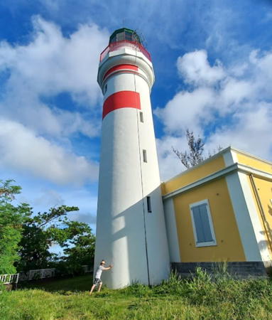
Pointe de Bel-Air Light, Sainte-Suzanne, February 2024
ex-Google Maps photo by Jean Luc Abelard
Saint-Paul and Port Réunion Lighthouses
Port Réunion (officially Le Port, Réunion), the island's only commercial port, is at the northwestern corner of the island about 25 km (15 mi) west southwest of the capital, Saint-Denis.

*
Saint-Paul
Date unknown. Active; focal plane 20 m (66 ft); white light, 3 s on, 1 s off. 18 m (59 ft) square skeletal tower. Simon Bénéteau has a closeup 2017 street view and Google has a 2016 street view and a satellite view. Located on the Quai Gilbert near the jetty in downtown Saint-Paul, about 10 km (6 mi) south of Port Réunion. Site open, tower closed. Admiralty D7092; NGA 33020.
* Port Réunion Jetée Sud (2)
Date unknown. Active; focal plane 13 m (43 ft); two green flashes every 6 s. 11 m (36 ft) hexagonal cylindrical concrete tower. Upper third of the tower painted green, lower 2/3 white. Trabas has Capt. Peter's photo, Bertrand Pierre Lefaux has a 2023 street view, and Google has a satellite view. This tower replaced a square skeletal tower with gallery and an enclosed structure below the gallery. A dramatic 2006 photo of the earlier light is available and Jérémie Noiret has a 2007 photo. Located at the end of the south jetty, guarding the entrance to the harbor. Accessible by walking or driving the pier. Site open, tower closed. Admiralty D7078; NGA 32908.
Port Réunion South Basin Range Front
Date unknown. Active; focal plane 18 m (59 ft); green light, 2 s on, 2 s off. 10 m (33 ft) concrete tower carrying a daymark painted white with a black verical stripe. No photo available but Google has a satellite view. Located across the street from the south basin of the harbor. Site and tower closed. Admiralty D7083; NGA 32928.
Port Réunion South Basin Range Rear
Date unknown. Active; focal plane 21 m (69 ft); green light, 2 s on, 2 s off. 12 m (39 ft) concrete tower carrying a daymark painted white with a black verical stripe. No photo available but Google has a satellite view. Located 60 m (200 ft) south of the front light. Site and tower closed. Admiralty D7083.1; NGA 32932.
Port Réunion Entrance Range Front
Date unknown. Active; focal plane 20 m (66 ft); quick-flashing white light. 11 m (36 ft) concrete tower carrying a daymark painted white with a black verical stripe. No photo available but Google has a satellite view. Located at the eastern edge of the main harbor basin. Site status unknown. Admiralty D7080; NGA 32900.
Port Réunion Entrance Range Rear
Date unknown. Active; focal plane 28 m (92 ft); quick-flashing white light. 17 m (56 ft) concrete tower, carrying a daymark painted white with a black verical stripe, mounted atop a 2-story building. No photo available but Google has a satellite view. Located across the street, about 80 m (265 ft) east of the front light. Site status unknown. Admiralty D7080.1; NGA 32904.
Port Réunion North Basin Leading
Date unknown. Active; focal plane 28 m (92 ft); white, red or green light depending on direction, occulting once every 4 s. Approx. 20 m (66 ft) white concrete tower. No photo available but Bing has a satellite view. Located on a quay in the north basin of the harbor. Site and tower closed. Admiralty D7082.3; NGA 32920.
* Le Port (Port Réunion)
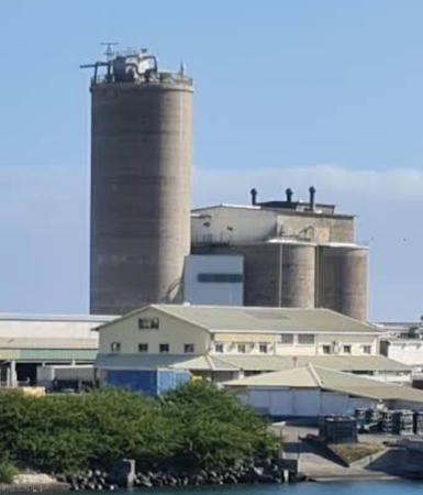
Date unknown. Active; focal plane 31 m (102 ft); two white flashes every 6 s. 26 m (85 ft) cement silo, according to NGA. Part of Miezan Aka's 2021 distant view is seen at right, Julie Alexandre posted a 2005 view from the north jetty, Trabas has Capt. Peter's photo, and Google has a satellite view. This is not a very glamorous lighthouse, but it is the landfall light for the port with a range of 39 km (24 mi). Located just inside the entrance to Port Réunion, on the north side of the harbor. Site and tower closed. Site manager: Holcim. Admiralty D7077; NGA 32896.


Port Réunion Light, Port Réunion, May 2021
Google Maps photo by Miezan Aka

* Port Réunion Jetée Nord (2)
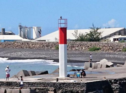
Date unknown. Active; focal plane 13 m (43 ft); two red flashes every 6 s. 11 m (36 ft) hexagonal cylindrical concrete tower. Upper third of the tower painted red, lower 2/3 white. Trabas has Capt. Peter's photo seen at right, a view from the sea is available, Eric Leroy has a distant view of both jetty lights, and Google has a satellite view. Jérémie Noiret has a 2007 closeup photo of the earlier light. Located at the end of the north jetty, guarding the entrance to the harbor. Accessible by walking or driving the pier. Site open, tower closed. ARLHS REU-015; Admiralty D7081.9; NGA 32912.
Port Est Jetée de l'Ouest
Date unknown. Active; focal plane 15 m (49 ft); green flash every 4 s. 10 m (33 ft) elliptical cylindrical concrete tower with a flared top. Lighthouse painted white with a green band at the top. Trabas has Hartmann's photo, a drone view is available, and Google has a satellite view. Located on the short west jetty of the newer Port Est (East Port), about 4 km (2.5 mi) east of the older port. Site status unknown. Admiralty D7083.75; NGA 32952.
Port Est West Basin Range Front
Date unknown. Active; focal plane about 20 m (66 ft); continuous (?) green (?) light. Approx. 18 m (59 ft) triangular white skeletal tower carrying a daymark painted white with a green vertical stripe. Trabas has Hartmann's photo and Google has an indistinct satellite view. Located in the harbor area at the end of the basin. Site and tower closed. Admiralty D7083.81.
Port Est West Basin Range Rear
Date unknown. Active; focal plane about 28 m (92 ft); continuous (?) green (?) light. Approx. 25 m (82 ft) triangular white skeletal tower carrying a daymark painted white with a green vertical stripe. Trabas has Hartmann's photo and Google has an indistinct satellite view. Located about 75 m (250 ft) west of the front light. Site and tower closed. Admiralty D7083.82.

Jetée Nord Light, Port Réunion, March 2017
photo copyright Capt. Peter Mosselberger; used by permission
Port Est (Leading Light)
Date unknown. Active; focal plane 38 m (125 ft); light continuous or flashing, white, red or green depending on direction. Approx. 7 m (23 ft) square concrete tower painted white with a large rectangular black daymark. Trabas has Hartmann's photo and Google has a satellite view. Located on the slope behind Port Est. Site and tower closed. Admiralty D7083.61; NGA 32948.
Port Est Jetée de l'Est
Date unknown. Active; focal plane 15 m (49 ft); red flash every 4 s. 10 m (33 ft) elliptical cylindrical concrete tower with a flared top. Lighthouse painted white with a red band at the top. Jérome Gabriel has a closeup photo, Trabas has Hartmann's photo, a drone view is available, and Google has a satellite view. Located on the short east jetty of the newer Port Est (East Port). Site status unknown. Admiralty D7083.7; NGA 32956.

North Coast Lighthouses
** Pointe de Bel-Air (Sainte-Suzanne)
1846. Active; focal plane 48 m (157 ft); three white flashes every 15 s. 25 m (82 ft) cylindical masonry tower with lantern and gallery. Tower painted white with a red band below the gallery; lantern is metallic green. The 1-story keeper's house houses the tourism office for northern Réunion. Réunion's only surviving nineteenth century lighthouse. A 2024 photo by Jean Luc Abelard is at the top of this page, another page for the lighthouse is available, Trabas has Philipp's photo, Celine Mercury has a 2024 photo, a 2011 closeup is available, Lighthouse Digest has a historic photo contributed by Michel Forand, Huelse has a historic postcard view, and Google has a street view and a satellite view. The lighthouse was staffed until 1985, with keepers winding the clockwork mechanism every 4 hours. Although Guyomard writes that the lighthouse is not visitable, it was fully restored in 1996 and has been open to the public ever since. The restoration was the result of efforts by the Association pour la Sauvegarde du Patrimoine de Sainte-Suzanne (Assaupass), which now manages the light station. Located at Sainte-Suzanne, about 25 km (15 mi) east of Saint-Denis. Site open, tower open for climbing on the second Saturday and last Tuesday of each month year round. Site manager: Office de Tourisme Intercommunal du Nord de la Réunion. . ARLHS REU-002; Admiralty D7084; NGA 32972.
* Sainte-Rose-la-Marine
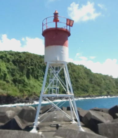
Date unknown. Active; focal plane 15 m (49 ft); four flashes every 15 s, white or red depending on direction. 7 m (23 ft) square skeletal tower with lantern and gallery. Tower painted white, lantern and gallery red. A Google street view by Eddy Chane Hin Chun is at right, Trabas has Philipp's photo, Guyomard and Carceller have a photo, and Google has a satellite view. Located at the end of the breakwater mole of a small boat harbor at Saint-Rose on the northeast coast of the island. Site open, tower closed. ARLHS REU-016; Admiralty D7085.

South Coast Lighthouses
* Pointe de la Table
About 1989. Active; focal plane 60 m (197 ft); white light occulting twice every 6 s. 6 m square cylindrical concrete skeletal tower, the lower half enclosed, with gallery. The tower is unpainted gray concrete. The light peeks above trees in Google's satellite view. The lighthouse was built on a 1986 lava flow from the nearby Piton de la Fournaise volcano, which added some 30 hectares (74 acres) to the area of the island. Located at the southeastern tip of Réunion, about 3 km (2 mi) northeast of Saint-Phillippe. The entrance to the road leading to the lighthouse is marked but easy to miss. Site open, tower closed. ARLHS REU-001; Admiralty D7086; NGA 32976.

Sainte-Rose-la-Marine Light, Sainte-Rose, March 2017
Google Maps street view by Eddy Chane Hin Chun
* Saint-Pierre (Terre-Sainte) (2)
2018 (station establishment date unknown). Active; focal plane 13 m (43 ft); flash every 4 s, white or green depending on direction. 11 m (36 ft) round metal post, painted white with a green horizontal band at the top. Fred Valou has a 2018 photo and Emmanuel Rivas has a nice 2019 photo. This light replaced a square skeletal tower with gallery and an enclosed structure below the gallery. Wikimedia has photos of the earlier light, Vincent Piton has a 2017 closeup street view, and Google has a satellite view. Located on the east breakwater at Saint-Pierre, the principal town on the south coast of Réunion. Accessible by walking the pier. Site open, tower closed. ARLHS REU-013; Admiralty D7089.05; NGA 32978.

Information available on lost lighthouses:

Notable faux lighthouses:

Adjoining pages: North: Seychelles | East: Mauritius

Return to the Lighthouse Directory index | Ratings key

Posted November 14, 2005. Checked and revised April 15, 2024. Lighthouses: 18. Site copyright 2024 Russ Rowlett and the University of North Carolina at Chapel Hill.