Lighthouses of Southern Angola

The Republic of Angola is a large nation of southwestern Africa, located south of the Congo and north of Namibia. It has a coastline 1600 km (995 mi) long facing west on the South Atlantic Ocean. A former Portuguese colony, Angola dissolved into civil war immediately upon independence in 1975. The long and bitter war finally ended in 2002 but the country is still working on recovery.

Nearly all of Angola's lighthouses were abandoned during the civil war and some were destroyed in the fighting. In recent years the Portuguese Navy has assisted in efforts to restore or replace and relight many of the lights.

This page includes the lighthouses of the southern half of Angola, including the provinces of Namibe and Benguela. The Northern Angola page has lighthouses of the rest of the country.

Lighthouses in Angola are maintained by the National Maritime Agency (AMN).

Portuguese continues as the language of government and trade in Angola, along with four indigenous languages. The Portuguese word for a lighthouse is farol, plural faróis; a small lightbeacon is often called a farolim. In Portuguese ilha is an island, ilhéu is an islet, cabo is a cape, ponta is a promontory or point of land, rocha is a rock, recife is a reef, baía is a bay, estreito is a strait, rio is a river, and porto is a port or harbor.

Current information and photos for many Angolan light stations are badly needed. Special thanks are due to José da Palma for his work in visiting lighthouses of Benguela and Kwanza Sul provinces. Entries for those areas depend heavily on his observations.

ARLHS numbers are from the ARLHS World List of Lights. PT numbers are from volume II of the Portuguese light list as supplied by the Admiralty. Admiralty numbers are from volume D of the Admiralty List of Lights & Fog Signals. U.S. NGA List numbers are from Publication 113.

General Sources
Online List of Lights - Angola - South Coast
Photos by various photographers posted by Alexander Trabas. This collection includes photos taken by José da Palma in January 2012, some of which appear on this page.
World of Lighthouses - Angola
Photos by various photographers available from Lightphotos.net.
Lighthouses in Angola
Photos by various photographers available from Wikimedia.
Afrikanischen Leuchttürme auf historischen Postkarten
Historic postcard views posted by Klaus Huelse.
Google Maps
Satellite view of southern Angola.


Lobito Light, Benguela, February 2018
Google Maps photo by José Sampaio Teixeira

Namibe Province Lighthouses
Namibe Province includes the southwestern desert coast of Angola. It is sparsely populated and 40% of the population lives in Moçâmedes, the capital and principal port. The province was called Moçâmedes under Portuguese rule. The provincial capital of Moçâmedes was renamed Namibe in 1985 and regained its Portuguese name in 2016, but the province continues to be called Namibe.

Ponta da Marca (2?)
Date unknown (station established 1920s or early 1930s). Active(?); focal plane 15 m (49 ft); three white flashes every 11 s. 13 m (43 ft) white conical tower on piles, according to the current Admiralty List; formerly a square skeletal tower with lantern, gallery, and enclosed watch room. No photo available but Google has a satellite view. Located at the end of a sand spit enclosing the Baía dos Tigres. This location is the westernmost point of Angola, in the extreme southwestern corner of the country. Site presumably open but very remote, tower closed. ARLHS ANO-012; PT-5618; Admiralty D5460; NGA 25724.
Leão (2.)
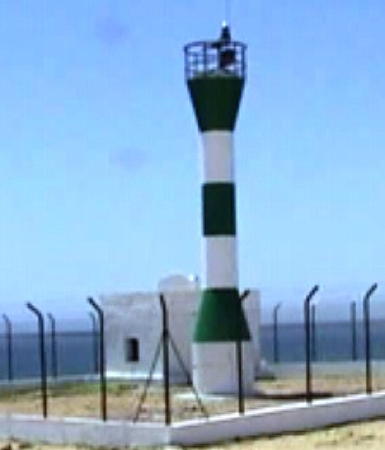
Date unknown. Active; focal plane 11 m (36 ft); green light occulting twice every 6 s. 10 m (33 ft) barbell-shaped fiberglass tower colord with green and white horizontal bands. Endangered; Paulo Dolbeth e Costa's 2024 photo at right shows the tower with a dangerous lean. Google has a satellite view. NGA lists a 10 m (33 ft) square gray metal tower. Located at Leão ("lion"), a small settlement on the Baía dos Tigres about 11 km (7 mi) south of the Ponta da Marca. Site presumably open but very remote, tower closed. PT-5622; Admiralty D5464; NGA 25728.

Leão Light, Leão, May 2024
Google Maps photo by Paulo Dolbeth e Costa
Ponta Albina (4?)
Around 2010 (station established 1920s). Active; focal plane 35 m (115 ft); two white flashes every 10 s. 38 m (124 ft) square skeletal tower with lantern and gallery. Lighthouse painted white. No photo available but Google has a satellite view. Earlier Google satellite views showed that the previous lighthouse, a similar tower mounted on a 1-story keeper's house, had been destroyed. The earlier lighthouse was a sibling of the second Ponta dos Palmeirinhas lighthouse. Located on a prominent point of land about 25 km (15 mi) southwest of Tombua. Site status unknown. ARLHS ANO-011; PT-5612; Admiralty D5442; NGA 25720.
Tombua (Tombwa, Porto Alexandre) (2?)
Date unknown (1920s or early 1930s). Active (?); focal plane 11 m (36 ft); white or green light, depending on direction, occulting three times every 9 s. NGA describes an 8 m (26 ft) tripod tower mounted atop a 1-story building. No photo available but Google has a satellite view. This is one of several lights in Namibe reported to have been rehabilitated in 2008; the satellite view suggests that the light was moved to a fiberglass tower next to the building. Located at the end of a sand spit protecting the harbor of Tombua (called Porto Alexandre under colonial rule), marking the west side of the harbor entrance. Site status unknown. PT-5606; Admiralty D5436; NGA 25716.
Rio dos Flamingos
Date unknown (since 1967). Active; focal plane 110 m (361 ft); three white flashes every 15 s. 11 m (36 ft) round cylindrical concrete tower attached to a duplex keeper's house. Lighthouse painted with vertical yellow and white stripes. José Rocha has a photo and Google has a satellite view. Located high on a bluff north of the dry riverbed, 1.2 km (3/4 mi) from the coast and about 40 km (25 mi) south of Moçâmedes. Site status unknown. ARLHS ANO-027; PT-5600; Admiralty D5430; NGA 25712.
Ponta do Noronha (Ponta do Pau do Sul) (1)
1950s?. Inactive. 4 m (13 ft) square 1-story concrete service building, now painted all white. A 2007 photo is at right. The light was formerly mounted on the roof. This modest building survives next to the modern light.
Ponta do Noronha (Ponta do Pau do Sul) (2)
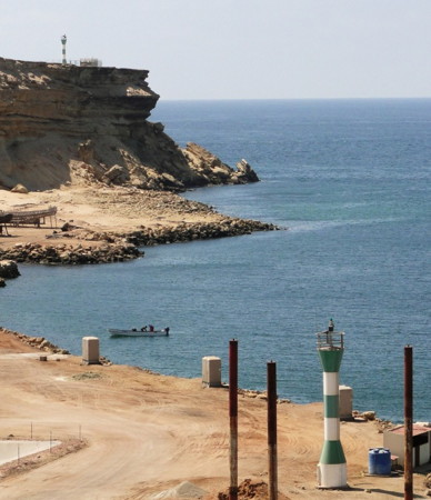
2006 (station established 1950s?). Active; focal plane approx. 45 m (148 ft); flash every 3 s, white or green depending on direction. Approx. 10 m (33 ft) round hourglass-shaped fiberglass tower painted with green and white horizontal bands. A 2007 photo is at right, Steffen Neumann's distant view is available, Tiago Campos de Carvalho has a sunset view, and Google has a satellite view. NGA misspells the name as Nornonha. Located atop a spectacular cliff on the south side of the entrance to the Baía de Namibe, about 5 km (3 mi) west of the waterfront. Site status unknown. ARLHS ANO-039; Admiralty D5414; NGA 25708.


Ponta do Noronha Light, Moçamdes, January 2007
Flickr Creative Commons photo by Princesa-do-Namibe

#Moçâmedes (Namibe) Quay (2)
Date unknown (2014?). Removed in 2021, although the light remains on the Admiralty list. This was an approx. 10 m (33 ft) round hourglass-shaped fiberglass tower painted with green and white horizontal bands. A 2015 photo by Steffen Neumann is available but the light is no longer seen in Google's satellite view. In 2012 the Admiralty was listing a 3 m (10 ft) "column" for this light. Located at the north end of the commercial harbor sheltered by Ponta do Noronha. Site status unknown. PT-5548; Admiralty D5420; NGA 25704.
* Fortaleza de São Fernando
Date unknown (late 1930s?). Active; focal plane 29 m (95 ft); red light occulting twice every 6 s. 4 m (13 ft) equipment building, painted white and mounted on the historic fort; the light is on a mast atop the roof. Alexander Nalivko has a photo of the fort, another view is available, and Google has a satellite view. The Admiralty reported this light reactivated in 2006. Located on the waterfront in Moçâmedes. Site open, tower closed. ARLHS ANO-032; PT-5544; Admiralty D5418; NGA 25700.
Saco (Porto Salazar) Range Front (2?)
Date unknown (1967?). Active(?); focal plane 10 m (33 ft); red light, 1 s on, 1 s off. NGA's description is "white column, tower." Google's satellite view suggests a fiberglass tower. Jeremias Malheiro has a photo that shows what may be an earlier tower leaning on the beach. Porto Salazar is an iron ore terminal located 12 km (7.5 mi) north of Moçâmedes. Portugal built this terminal in 1966-67 to ship iron ore from the Cassinga mine in the interior of the country. These shipments stopped during the civil war and have not resumed. The port was named originally for the Portuguese dictator António de Oliveira Salazar. Located on the waterfront. Site probably open, tower closed. Admiralty D5404; NGA 25692.
Saco (Porto Salazar) Range Rear
Date unknown (1967?). Active(?); focal plane 48 m (158 ft); red light, 2 s on, 2 s off. NGA's description is "white column, tower." Google's satellite view suggests a skeletal tower atop a base of some kind. Located about 2.7 km (1.7 mi) northeast of the front light. Site probably open, tower closed. Admiralty D5404.1; NGA 25696.
* Ponta do Giraúl (Namibe, Moçâmedes) (2)
Date unknown (late 1930s?) (station established 1886). Inactive. 24 m (79 ft) square cylindrical masonry tower with lantern and gallery, rising from a 1-story keeper's house. A second 1-story keeper's house is nearby. Endangered. A 2024 photo by Cristiane Freitas is at right, Alberto Cardoso has a 2022 photo, Jürgen Klinksiek contributed Steffen Neumann's photo, a 2007 closeup photo and a historic closeup taken in the 1960s are available, Tomasz Poskrobko has a 2018 photo, and Google has a satellite view. Located atop a vertical cliff at the northern entrance to the Baía de Namibe, about 16 km (10 mi) northwest of Namibe. Site open, tower closed. ARLHS ANO-019.


New and Old Ponta do Giraúl Light, Namibe, April 2024
Google Maps photo by Cristiane Freitas

* Ponta do Giraúl (Namibe, Moçâmedes) (3)
Date unknown (probably around 2005). Active; focal plane 30 m (98 ft) (?); white flash every 5 s. Approx. 20 m (66 ft) round barbell-shaped fiberglass tower colored with red and white horizontal bands. Modern 1-story keeper's house. A 2024 photo by Cristiane Freitas is above right, Aparicio Campos has a 2022 photo, Sumit Pandey has a 2019 photo. Jürgen Klinksiek contributed Steffen Neumann's photo and Afonso Hipocrates has a 2017 photo showing the old and new towers. The new light was not seen in a 2004 view by Oscar Carmo (no longer online). Site open, tower closed. PT-5525; Admiralty D5400; NGA 25688.
Ponta Piambo
Date unknown (station established 1968 (?)). Reactivated; focal plane 54 m (177 ft); three white flashes every 10 s. 12 m (39 ft) square masonry tower, rising from the center of a keeper's house. Lighthouse painted with blue and white horizontal bands. Gualter Matos has a 2020 photo and Google has a satellite view. This lighthouse was restored in 2008 and it appears to be in good condition. Located on an isolated headland about 80 km (50 mi) north of Namibe. Site status unknown. ARLHS ANO-023; PT-5510; Admiralty D5370; NGA 25684.
Ponta Grossa
Date unknown (late 1930s?). Reactivated; focal plane 50 m (164 ft); four white flashes every 12 s. 14 m (46 ft) square masonry tower, rising from the north end of a keeper's house. Lighthouse painted white. Eric Lafforgue has a 2010 closeup photo and Google has a good satellite view. Like the Ponta Piambo lighthouse this historic lighthouse has been restored and re-equipped with a solar-powered light. Located on a headland about 10 km (6 mi) northwest of Bentiaba. Site status unknown. ARLHS ANO-022; PT-5500; Admiralty D5356; NGA 25680.
* Cabo de Santa Marta
1925. Active; focal plane 48 m (157 ft); two white flashes every 6 s. 14 m (46 ft) hexagonal cylindrical masonry tower attached to a 1-story equipment building. Lighthouse painted white. 1-story keeper's cottage and several smaller buildings. A 2019 Facebook photo is at right and Google has a satellite view. This is one of several lights in Namibe reported to have been rehabilitated in 2008. Located on a headland about 15 km (9 mi) west of Lucira. Site open, tower closed. . ARLHS ANO-006; PT-5450; Admiralty D5346; NGA 25676.

Cabo de Santa Marta Light, Lucira, March 2019
Facebook photo by Cabo de Santa Marta

Benguela Province Lighthouses
Benguela Province is on the south central coast of Angola. Its capital, Benguela, has a population of more than half a million. Lobito, about 20 km (13 mi) north of Benguela, is a major port with a population of about 400,000. Lobito is the terminal of the historic Benguela Railway, completed in 1929 to bring copper ore and other minerals from Congo and Zambia. The railway was almost completely destroyed during Angola's civil war. It was rebuilt by a Chinese company and rededicated in 2015.

Cabo de Santa Maria
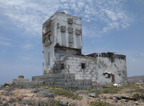
1939. Inactive, although still listed at focal plane 102 m (335 ft); three white flashes every 13 s. 12 m (39 ft) square cylindrical masonry tower, formerly with lantern and gallery, rising from a small 1-story keeper's house. Lighthouse painted white; lantern destroyed and removed. Trabas has José da Palma's 2012 photo (also seen at right) and the light station also appears abandoned in a Google satellite view. Endangered. This station was heavily damaged during the civil war and there has been no effort to restore it. Located on a headland at Santa Maria. Site open but very difficult to reach except by sea. ARLHS ANO-005; PT-5440; Admiralty D5336; NGA 25672.
Ponta dos Frades
Date unknown (after 1967). Reactivated(?); focal plane 148 m (486 ft); white light occulting twice every 7.5 s. 9 m (30 ft) round white concrete tower attached to a white concrete duplex keeper's house. José da Palma has contributed a photo, Trabas has a different 2012 photo by Da Palma, and Google has a satellite view. Endangered (?). Da Palma found the lighthouse looted but basically intact in 2012. The Admiralty reported it reactivated in March 2019. Located on a headland about 35 km (22 mi) northeast of Santa Maria. Site open but difficult to reach. ARLHS ANO-021; PT-5436; Admiralty D5328; NGA 25668.
Ponta das Salinas (3)
2006 (station established 1888). Reactivated; focal plane 39 m (128 ft); white flash every 4 s. 38 m (125 ft) square skeletal tower with lantern and gallery, mounted on a concrete base. Trabas has José da Palma's 2011 photo and Google has a satellite view. This lighthouse was built in 2005-06 to replace a pyramidal skeletal tower. Located on a prominent point of land about 80 km (50 mi) southwest of Benguela. Site open (lighthouse fenced), tower closed. Accessible by 4x4 vehicles. ARLHS ANO-016; PT-5430; Admiralty D5324; NGA 25664.
Santa Maria Light
Cabo de Santa Maria Light, January 2012
photo copyright José da Palma; used by permission
* Baía Farta (Ponta de São José) (2?)
Date unknown (station established 1953). Active; focal plane 11 m (36 ft); green flash every 3 s. 10 m (33 ft) post light centered on a square 1-story equipment shelter. Lighthouse colored with red and white horizontal bands. Trabas has José da Palma's 2012 photo and Google has a satellite view. The lighthouse was renovated or replaced in 2005-06. Located on the beach on a sandy point north of Baía Farta, a fishing town about 40 km (25 mi) west of Benguela. Site open (lighthouse fenced), tower closed. Accessible by a short walk from the village, which can be reached by car from Benguela. ARLHS ANO-030; Admiralty D5318.
Ponta do Sombreiro (4)
2006 (station established 1885). Active; focal plane about 130 m (427 ft); white light occulting once every 9 s. 15 m (49 ft) round fiberglass tower, colored with red and white horizontal bands. 1-story keeper's house covered with blue siding. Trabas has one of José da Palma's 2012 photos, another one is at right, and Google has a satellite view. Located on a hilltop about 800 m (1/2 mi) southwest of the historic light station (next entry). Accessible by road (local guidance may be needed). Site open (light station fenced), tower closed. PT-5420; Admiralty D5312; NGA 25648.
Ponta do Sombreiro (3)
Date unknown (1950s?) (station established 1885). Inactive for many years. 7 m (23 ft) post mounted on a small equipment building. Keeper's cottage, unroofed and in ruins. José da Palma has contributed a distant photo, a distant 2015 photo is available, and Google has a satellite view. Roberto Torres has a distant view of the mountain that shows the station at high zoom levels. A 1939 chart (no longer online) has an image of a tall skeletal tower here. Located atop a very prominent headland (supposedly shaped like a sombrero) on the west side of the Baía de Benguela about 10 km (6 mi) west of the city. Site status unknown; José da Palma was unable to reach the station in 2012 because the road had been lost to erosion.
* Benguela Range Front
Date unknown (early/mid 1950s?). Active; focal plane 11 m (36 ft); flash every 2 s, white, red or green depending on direction. 7 m (23 ft) square tower with gallery, colored with red and white horizontal bands and also bearing a cross of the Order of Christ. Trabas has José da Palma's 2012 photo and Google has a satellite view. The deepwater port of Benguela is at Lobito; at the city itself there is no sheltered harbor. The range guides smaller vessels to an area where it is safe to anchor. Located on the beach 490 m (0.3 mi) northwest of the rear light (next entry), in an area used by Angolan police. Site and tower closed, but the light can be seen from the beach. ARLHS ANO-031; PT-5410; Admiralty D5300; NGA 25652.

Ponta do Sombreiro Light, Benguela, January 2012
photo copyright José da Palma; used by permission
* Benguela Range Rear
Date unknown (1930s?). Reported inactive in 2012; focal plane 16 m (52 ft); red lens. Light mounted on a 12 m (39 ft) square tower of the church of Nossa Senhora do Pópulo. The light can be seen in the left (north) tower of the church in Dario Meyer's 2016 photo and in Trabas's 2012 photo by José da Palma. Werner Müller has a 2025 photo of the historic (1748) church and Google has a satellite view. Located on a main street in downtown Benguela, about 400 m (1/4 mi) from the shore. Site open, tower status unknown. Admiralty D5300.1; NGA 25656.
* Ponta da Restinga (Ponta do Lobito) (2)
Date unknown (1930s?) (station established about 1910). Active; focal plane 14 m (46 ft); white light occulting once every 6 s. 10 m (33 ft) square pyramidal skeletal tower with gallery but no lantern, painted with red and white horizontal bands. The lower third of the tower is enclosed by what appear to be metal panels. Steffen Neumann's photo is at right, Trabas has José da Palma's 2012 photo, Frederico Sá Pinto has posted an August 2004 photo (2/3 of the way down the page), and Google has a satellite view. Lighthouse Digest has a postcard view of the original lighthouse contributed by Michel Forand; it was a square skeletal tower with lantern and gallery. The port of Lobito is sheltered by a narrow sandy spit that forms a natural breakwater. Located at the end of the spit, marking the west side of the harbor entrance. Site open, tower fenced and closed. Accessible by car. ARLHS ANO-037; PT-5400; Admiralty D5288; NGA 25644.
* Lobito (1)
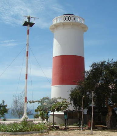
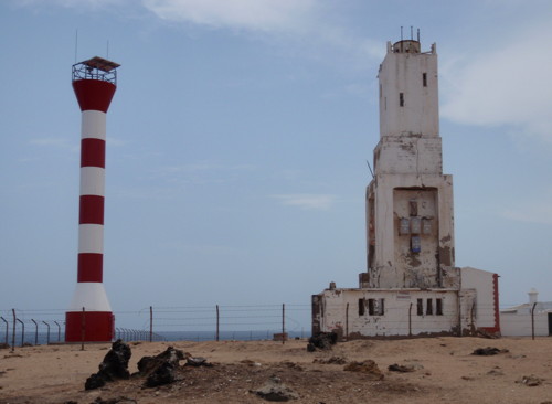
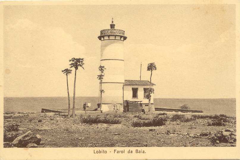
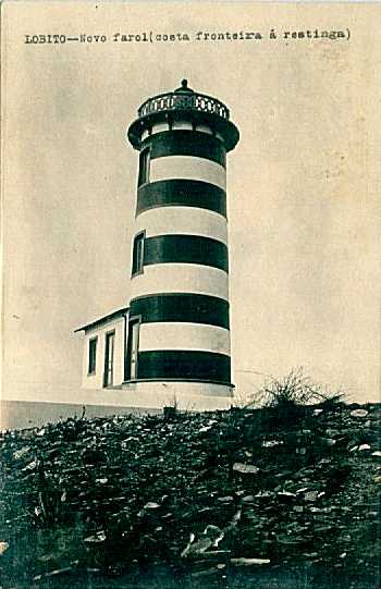
1915. Inactive. 15 m (49 ft) cylindrical masonry tower with gallery and a small lantern, attached to a small keeper's cottage. Lighthouse painted white with one red horizontal band. The active light (focal plane 106 m (348 ft); two white flashes every 10 s) has been moved to a mast, also painted with red and white bands, next to the historic tower. A 2018 photo by José Sampaio Teixeira is at the top of this page, Claus Bunks has a 2007 closeup photo, Trabas has José da Palma's distant 2012 view, and Google has a good satellite view. In an older photo (no longer online) the lighthouse was painted all white. Klaus Huelse has a historic postcard view and a second postcard view showing the tower with a series of horizontal red or black and white bands. Damaged during Angola's civil wars, the lighthouse was nicely restored sometime between 2004 and 2007 and converted to a guest house. Located atop the bluffs on the east (mainland) side of the harbor entrance, north of the city. Da Palma found this area closed in early 2012 due to mine removal operations nearby. Site normally open, tower closed. ARLHS ANO-008. Active light: PT-5315; Admiralty D5280; NGA 25640.
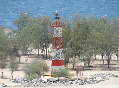
Ponta da Restinga Light, Lobito, October 2015
photo copyright Steffen Neumann, courtesy of Jürgen Klinksiek; used by permission
[Ponta do Egito]
Date unknown (since 1967). Still listed, but inactive for many years and now largely destroyed. This was a 9 m (30 ft) tower, originally painted with red and white vertical stripes. No photo of that light is available, but Trabas has José da Palma's 2012 photo of what remains, and the station is seen in Google's satellite view. Da Palma visited this station in early 2012; he found it to be abandoned, with a ruined keeper's house. The light tower was blown up during the civil war. Located on a headland about 5 km (3 mi) southwest of Egito Praia, a small town about 40 km (25 mi) north northeast of Lobito. The site is very difficult to reach. ARLHS ANO-018; PT-5305; Admiralty D5270; NGA 25636.

Information available on lost lighthouses:

Notable faux lighthouses:

Adjoining pages: North: Northern Angola | South: Namibia

Return to the Lighthouse Directory index | Ratings key

Posted September 30, 2005. Checked and revised May 26, 2026. Lighthouses: 26. Site copyright 2026 Russ Rowlett and the University of North Carolina at Chapel Hill.