Lighthouses of Northern Angola

The Republic of Angola is a large nation of southwestern Africa, located south of the Congo and north of Namibia. It has a coastline 1600 km (995 mi) long facing west on the South Atlantic Ocean. A former Portuguese colony, Angola dissolved into civil war immediately upon independence in 1975. The long and bitter war finally ended in 2002 but the country is still working on recovery.

Nearly all of Angola's lighthouses were abandoned during the civil war and some were destroyed in the fighting. In recent years the Portuguese Navy has assisted in efforts to restore or replace and relight many of the lights.

This page includes the lighthouses of the southern half of Angola, including the provinces of Kwanza Sul, Bengo, Luanda, Zaire, and Cabinda. The Southern Angola page has lighthouses of the rest of the country.

Lighthouses in Angola are maintained by the National Maritime Agency (AMN).

Portuguese continues as the language of government and trade in Angola, along with four indigenous languages. The Portuguese word for a lighthouse is farol, plural faróis; a small lightbeacon is often called a farolim. In Portuguese ilha is an island, ilhéu is an islet, cabo is a cape, ponta is a promontory or point of land, rocha is a rock, recife is a reef, baía is a bay, estreito is a strait, rio is a river, and porto is a port or harbor.

Current information and photos for many Angolan light stations are badly needed. Special thanks are due to José da Palma for his work in visiting lighthouses of Benguela and Kwanza Sul provinces. Entries for those areas depend heavily on his observations.

ARLHS numbers are from the ARLHS World List of Lights. PT numbers are from volume II of the Portuguese light list as supplied by the Admiralty. Admiralty numbers are from volume D of the Admiralty List of Lights & Fog Signals. U.S. NGA List numbers are from Publication 113.

General Sources
Online List of Lights - Angola
Photos by various photographers posted by Alexander Trabas. This collection includes photos taken by José da Palma in January 2012, some of which appear on this page.
World of Lighthouses - Angola
Photos by various photographers available from Lightphotos.net.
Lighthouses in Angola
Photos by various photographers available from Wikimedia.
Afrikanischen Leuchttürme auf historischen Postkarten
Historic postcard views posted by Klaus Huelse.


New and Old Sumbe Lights, Sumbe, January 2012
photo copyright José da Palma; used by permission
Kwanza Sul (Cuanza Sul) Province Lighthouses
Kwanza Sul province includes the central coast of Angola. It is primarily agricultural but Sumbe and Porto Amboim are important fishing ports.

Kikombo (Quicombo, Ponta Vermelha) (2)
2006 (station established 1939). Active; focal plane 137 m (449 ft); four white flashes every 12 s. 14 m (46 ft) round fiberglass tower, colored with red and white horizontal bands. Trabas has José da Palma's photo and Google has a satellite view. The original lighthouse here, a square masonry tower, was blown up during the civil war and only a few ruins remain. Located on a bluff south of the fishing village of Kikombo (Quicombo), about 20 km (13 mi) south of Sumbe. Accessible by car from the main road 5 km (3 mi) to the east. Site open, tower closed. ARLHS ANO-026; PT-5295; Admiralty D5250; NGA 25632.
* [Sumbe (Novo Redondo) (1)]
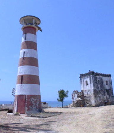
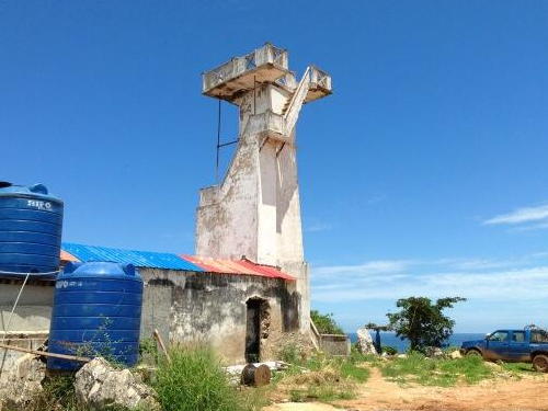
1889. Inactive. 7 m (23 ft) post formerly mounted on a 1-story house atop the northwest corner of a fort. The post has disappeared and the fort and the lighthouse are now in ruins. José da Palma has contributed the photo at right, another photo is available and Google has an indistinct satellite view. Located on a hill in downtown Sumbe (Novo Redondo), the capital of Kwanza Sul Province, about 200 m (220 yd) from the shore. Site open, tower closed.
* Sumbe (Novo Redondo) (2)
Date unknown (around 1970?) (station established 1889). Active; focal plane 34 m (112 ft); white flash every 3 s. Approx. 15 m (49 ft) masonry tower with lantern, painted with red and white horizontal bands. Trabas has José da Palma's closeup photo, Da Palma has also contributed the photo at right, another photo is available, and Google has a satellite view. Located next to the remains of the historic lighthouse. Site open. ARLHS ANO-036; Admiralty D5240; NGA 25628.
Porto Amboim (1)
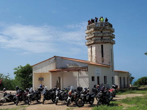
Date unknown (1920s or early 1930s). Inactive. 12 m (39 ft) white square tower with gallery, attached to a 1-story keeper's house. A photo is at right. Located on a prominent headland about 5 km (3 mi) southwest of Porto Amboim. Site status unknown. ARLHS ANO-024.
Porto Amboim (2)
Date unknown. Active; focal plane 110 m (361 ft); white light occulting twice every 6 s. Approx. 10 m (33 ft) round tower, painted white. Manuel S. Fonseca has a distant view and Google has a satellite view. Located a short distance seaward of the historic lighthouse. Site status unknown. PT-5272; Admiralty D5224; NGA 25624.
* Cambiri
Date unknown. Active; focal plane 64 m (210 ft); red flash every 4 s. 4 m (13 ft) concrete equipment shelter with a light on a short tower at one end. Building painted white. Mario Pinho has a closeup of the lens and a photo of one corner of the structure, the light is barely visible (on the right) in a view of the bluff and in Alex Marlony Dias Santos's street view, and Google has a satellite view. Located on a prominent headland in Porto Amboim. Site open, tower closed. PT-5270; Admiralty D5226; NGA 25612.
Cabo das Tres Pontas
Date unknown (late 1930s?). Active; focal plane 51 m (167 ft); two white flashes every 7 s. 14 m (46 ft) square masonry tower with lantern and gallery, attached to a 1-story keeper's house. Lighthouse painted white. No photo available but Google has an indistinct satellite view of the station. Located on a headland about 60 km (37 mi) northwest of Porto Amboim. Site status unknown. ARLHS ANO-004; PT-5260; Admiralty D5200; NGA 25608.

Porto Amboim Light, Porto Amboim, ca. 2012
ex-Twitter photo salvaged by Google Images

Southern Bengo Province Lighthouse
Bengo Province surrounds Luanda, the national capital. The capital city, with its population of more than 8 million (a third of the country's population), has been a separate province since 1980.

Cabo Ledo
Date unknown (late 1930s?). Active; focal plane 102 m (335 ft); three white flashes every 15 s. 11 m (36 ft) hexagonal masonry tower with gallery, attached to a 1-story keeper's house. Lighthouse painted white; the keeper's house roof is red tile. The lighthouse was heavily damaged by looters in 1994. The light station was restored in 2004 and the original lantern was removed at that time. A 2021 photo by Hélio Dias de Brito Teixeira is at right and Google has a satellite view of the station. Cabo Ledo, in southern Bengo Province 120 km (75 mi) south of Luanda, is famous for beautiful beaches and fine surfing; the government is working to improve security in this area enough to attract more foreign visitors. Located on a headland south of the town of Cabo Ledo. Site status unknown. ARLHS ANO-007; PT-5255; Admiralty D5180; NGA 25604.

Luanda Province Lighthouses
* [Ponta das Palmeirinhas (3)]
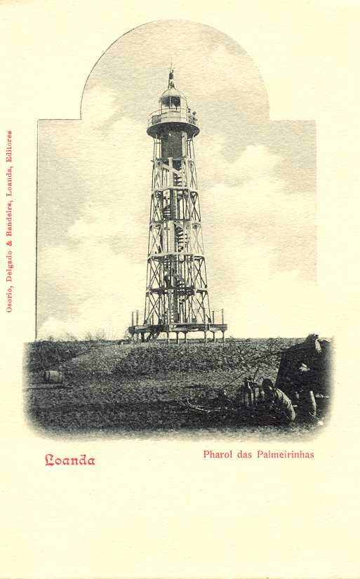
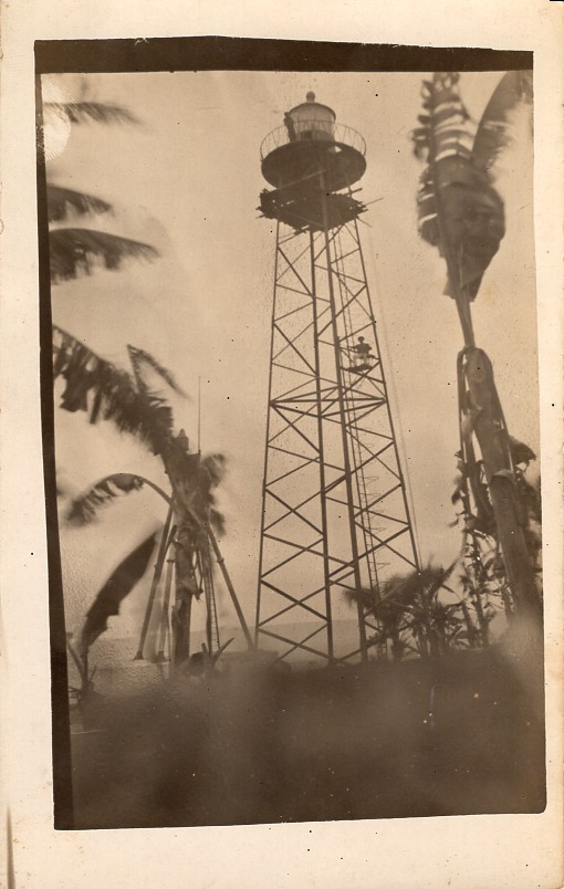
1936 (station established 1889). Inactive. Originally this was a square steel skeletal tower, roughly 27 m (89 ft) tall, mounted on a square 1-story concrete equipment building. The skeletal tower has collapsed but Octavio Perez has contributed a photo of the ruins of the equipment building and Google has a satellite view. Huelse has a postcard view of the second lighthouse, an octagonal cast iron skeletal tower with lantern and gallery roughly 23 m (75 ft) tall. Located on a prominent headland about 65 km (40 mi) southwest of Luanda. Site open, tower closed.
#Ponta das Palmeirinhas (4)
Date unknown (station established 1889). Replaced around 2019. This was an approx. 27 m (89 ft) square steel skeletal tower with gallery. Octavio Perez has contributed a photo. This tower was removed by 2021.

Cabo Ledo Light, Cabo Ledo, December 2021
Google Maps photo by Hélio Dias de Brito Teixeira
* Ponta das Palmeirinhas (5)
Around 2019 (station established 1889). Active; focal plane 40 m (131 ft); white flash every 4.5 s. Approx. 27 m (89 ft) square steel skeletal tower with gallery, painted with red and white horizontal bands. A small concrete equipment building stands next to the tower. No recent photo available but Google has a satellite view of the station. This light station marks a great westward bulge in the coastline south of Luanda. Located on a prominent headland about 65 km (40 mi) southwest of Luanda. Site open, tower closed. ARLHS ANO-015; PT-5250; Admiralty D5150; NGA 25600.
* Ilha do Cabo (Ilha do Luanda) (4)
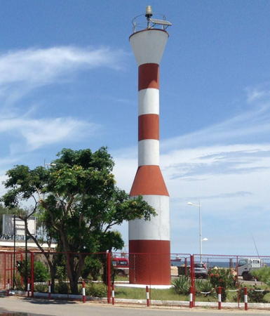
2002 or later (station established 1930s). Active; focal plane 11 m (36 ft); three white flashes every 8 s. 11 m (36 ft) fiberglass tower, painted with red and white horizontal bands. Rui Monteiro's 2023 photo is at right, Oloyede Ifeoluwa has a 2017 photo, Royer Elizandra has a 2009 photo, Eurico Xavier has a 2019 photo, Trabas has a view from the sea, and Google has a satellite view. The previous lighthouse was described as a square skeletal tower, painted white, mounted on a building. Wikimapia has an image of earlier lighthouse (perhaps the original). Luanda, the capital city of Angola, has one of the best harbors of southwestern Africa, sheltered behind a sandy barrier island known as Ilha do Cabo, Ilha do Luanda, or simply "The Ilha." The island is connected to the mainland by a causeway at its southern end. The lighthouse is located at the northern end, marking the entrance to the harbor. Accessible by road. Site open, tower closed. ARLHS ANO-033; PT-5205; Admiralty D5101; NGA 25584.
* Ponta das Lagostas (Mórro das Lagostas) (2)
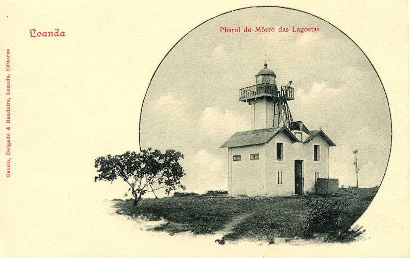
Around 1930 (station established 1880). Inactive. 14 m (46 ft) square cylindrical masonry tower with lantern and gallery. Lighthouse painted white. A 2019 photo is below right and Trabas has Douglas Cameron's 2015 view of the station. Endangered. Huelse has posted a historic postcard view of the original lighthouse, which had a lower focal plane of 64 m (210 ft). Located on a headland about 15 km (9 mi) northeast of Luanda. Site appears open, tower presumably closed. ARLHS ANO-014.
* Ponta das Lagostas (Mórro das Lagostas) (3)
Date unknown. Active; focal plane 81 m (266 ft); red light occulting twice every 6 s. Approx. 15 m (49 ft) round barbell-shaped tower with gallery, painted with red and white horizontal bands. A 2019 photo is below right, Trabas has Douglas Cameron's view, and Google has a satellite view. Site appears open, tower closed. PT-5204; Admiralty D5100; NGA 25576.

Ilha do Cabo Light, Luanda, March 2023
Google Maps photo by Rui Monteiro
* Cacuaco
Date unknown. Active; focal plane 11 m (36 ft); one long (2 s) yellow flash every 12 s. 9 m (30 ft) round hourglass-shaped fiberglass tower, painted with red and white horizontal bands, mounted on a square concrete base. No photo available but Google has a satellite view. Located on the waterfront at Cacuaco, a town about 30 km (19 mi) east of Luanda. Site open, tower closed. Admiralty D5090.

Northern Bengo Province Lighthouses
Barra do Dande (Ponta do Dande)
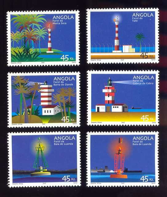
1968. Active; focal plane 63 m (207 ft); two white flashes every 10 s. 20 m (66 ft) square cylindrical masonry tower with lantern and gallery, attached to a 1-story keeper's house. Lighthouse painted with red and white horizontal bands; lantern roof painted blue. João Cunha has a 2018 photo, Dario Andrade has a 2022 closeup, there is a postage stamp image and Google has a satellite view. Located on a prominent headland sheltering the harbor of Barra do Dande. Site status unknown. ARLHS ANO-017; PT-5193; Admiralty D5080; NGA 25572.
Ambriz
1930s? (station established 1883). Active; focal plane 33 m (108 ft); four white flashes every 12 s. 14 m (46 ft) square cylindrical masonry tower with lantern and gallery, originally painted white. A photo is available and Google has a satellite view. Located on a headland near Ambriz. Site and tower closed (military base area). ARLHS ANO-001; PT-5180; Admiralty D5060; NGA 25568.

Zaire Province Lighthouses
Zaire Province is in the northwestern corner of Angola, separated from the Democratic Republic of the Congo (DRC) by the Congo River. The Congo River was called Zaire by Portuguese colonists, a name adapted from a native word nzere for a great river. The DRC was known as Zaire or Zaïre from 1971 to 1997.

Old and new Ponta das Lagostas Lights, Luanda, November 2019
Google Maps photo by t. m.
N'Zeto (Ambrizete) (2)
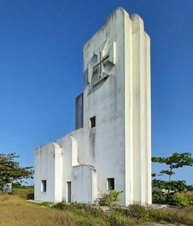
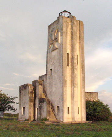
1930s? (station established 1888). Clearly inactive but listed with focal plane 34 m (112 ft); three white flashes every 10 s. 20 m (66 ft) square cylindrical masonry tower, originally painted white; the tower carries a cross-shaped daymark. A 2022 photo by Marco Santos is at right, Marco Santos's 2022 photo shows an abandoned lighthouse, Rosario Bidarra posted a 2007 photo, and Google has a satellite view. Endangered. Sailing directions mention a disused lighthouse here. Located on a headland about 5 km (3 mi) south of N'Zeto (Ambrizete). Site status unknown. ARLHS ANO-002; PT-5172; Admiralty D5040; NGA 25564.
Ponta do Quinzáu (Kinzau) (2?)
Date unknown (since 1967). Active; focal plane 55 m (180 ft); three short white flashes followed by one long (2.6 s) white flash every 12 s. Listed as a 15 m (49 ft) square cylindrical masonry tower, painted with black and yellow horizontal bands, but Google's satellite view appears to show a slender round tower painted with horizontal bands. The original lighthouse appears to be in ruins with no tower standing. No photo available. Located on a headland just south of Quinzau. Site status unknown. ARLHS ANO-020; PT-5166; Admiralty D5006; NGA 25560.
Cabeça da Cobra
1930s?. Active; focal plane 42 m (138 ft); white flash every 4 s. 13 m (43 ft) square cylindrical masonry tower with lantern and gallery, rising from the center of a 1-story keeper's house. Lighthouse painted with red and white horizontal bands. No photo available, but there is a postage stamp image (right stamp in second row) and Google has a satellite view. Located about 65 km (40 mi) south of Soyo. Site status unknown. ARLHS ANO-003; PT-5161; Admiralty D5003; NGA 25556.
Moita Seca (Congo River, Shark Point) (3)
2002 (station established 1889). Active; focal plane 20 m (66 ft); three white flashes every 10 s. 20 m (66 ft) fiberglass tower, painted with red and white horizontal bands. The light is seen in the center of Kellie Pendoley's distant aerial view, there is a postage stamp image (left stamp in first row), and Google has a satellite view. This modern light replaced a 1919 hexagonal cast iron skeletal tower, 24 m (79 ft) tall. The original light was on a post next to a keeper's house. The lighthouse stands at the base of a sandy spit on the south side of the entrance to the Congo River. Located about 15 km (9 mi) east of the river port of Soyo. Site status unknown. ARLHS ANO-035; PT-5030; Admiralty D4380; NGA 25528.

N'Zeto Light, N'Zeto, February 2022
Google Maps photo by Marco Santos

Cabinda Province Lighthouses
Cabinda is an exclave (a detached province) of Angola, separated from the rest of the country by a strip of the Democratic Republic of the Congo, about 50 km (30 mi) wide, along the north bank of the Congo (Zaire) River. Formerly known as Portuguese Congo, Cabinda was administered separately by Portugal until 1956. A long-running campaign by separatists has not succeeded in establishing Cabinda as an independent state, but some fighting continues. The city of Cabinda, the major town of the province, does not have a sheltered harbor; ships anchor in an open roads offshore. In July 2009 the Angolan government announced plans to develop a deep-water port in Cabinda; no timetable was given. Aids to navigation in Cabinda are maintained by the Porto de Cabinda.

Ponta do Táfe (Cabinda, Ponta de Farol) (4)
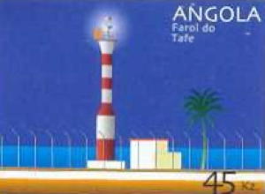
2002 (station established 1888). Active; focal plane 27 m (89 ft); two white flashes, separated by 3.5 s, every 10 s. 20 m (66 ft) fiberglass tower, painted with red and white horizontal bands. No photo available but there is a postage stamp image (seen at right) and Google has an indistinct satellite view. Huelse has a historic postcard view of the third lighthouse, a white square skeletal tower with lantern and gallery. Located at the tip of Ponta de Farol, a point of land at the south end of the bay of Cabinda, just southwest of the city. Site status unknown. ARLHS ANO-013; PT-5010; Admiralty D4340; NGA 25504.
Simulambuco Range Front (?)
Date unknown (since 1967). Active; focal plane 9 m (30 ft); red light, 1 s on, 1 s off. Square masonry tower, painted white. No photo available and the lighthouse is not seen in Google's satellite view. This is the entrance range for the Cabinda anchorage. Located on the waterfront in Cabinda. Site status unknown. ARLHS ANO-028; PT-5013; Admiralty D4343; NGA 25508.
Simulambuco Range Rear (?)
Date unknown (since 1967). Active; focal plane 46 m (151 ft); red light, 2 s on, 2 s off. Square masonry tower, painted white. No photo available and the lighthouse is not seen in Google's satellite view. Located 300 m (0.2 mi) east southeast of the front light in Cabinda. Site status unknown. ARLHS ANO-029; PT-5013.1; Admiralty D4343.1; NGA 25512.

Ponta do Táfe Light, Cabinda
Lighthouse Stamp Society postage stamp image
 
Malongo Range Front
Date unknown. Inactive since 2014 (still listed by NGA with focal plane 9 m (30 ft); red light, 1 s on, 1 s off). 10 m (33 ft) triangular solid concrete tower, unpainted. The shadow of the tower is seen in Google's satellite view. Malongo is the base for operations of Chevron Oil in Cabinda. Located on the waterfront, just north of the pier and about 40 km (25 mi) north of Cabinda. Site status unknown. ex-Admiralty D4332; ex-PT-5002; NGA 25496.
Malongo Range Rear
Date unknown. Inactive since 2014 (still listed by NGA with focal plane 121 m (397 ft); red light, 2 s on, 2 s off)). 10 m (33 ft) triangular solid concrete tower, unpainted. The shadow of the tower is seen in Google's satellite view. Located 400 m (1/4 mi) east northeast of the front light. Site status unknown. ex-Admiralty D4332.1; ex-PT-5002.1; NGA 25500.
Ponta de Lândana (Kakongo) (3)
Date unknown (1950s?) (station established 1888). Active; focal plane 60 m (197 ft); white light, 3 s on, 2 s off. 9 m (30 ft) square cylindrical masonry tower, painted white, rising from a 1-story keeper's house. No photo available but Google has a distant satellite view. Located on a headland just south of Kakongo (Cacongo), about 55 km (35 mi) north of Cabinda city. Site status unknown. ARLHS ANO-025; PT-5000; Admiralty D4326; NGA 25492.

Information available on lost lighthouses:

Notable faux lighthouses:

Adjoining pages: North: Republic of the Congo | Northeast: Democratic Republic of the Congo | South: Southern Angola

Return to the Lighthouse Directory index | Ratings key

Posted September 30, 2005. Checked and revised April 6, 2025. Lighthouses: 25. Site copyright 2025 Russ Rowlett and the University of North Carolina at Chapel Hill.