Lighthouses of Brazil: Espirito Santo

The Federative Republic of Brazil (Brasil in Portuguese), the largest country in South America and fifth largest in the world, has a lengthy coastline, a large number of lighthouses, and a distinguished lighthouse history. Colonized by Portugal, Brazil declared its independence in 1822. Uniquely among American nations it was a monarchy as the Empire of Brazil until 1889.

Brazil is a federal republic with 26 states and a federal district. This page covers the lighthouses of Brazil's east coast in the state of Espírito Santo. With a population of about 4 million, Espírito Santo occupies the coastal region between the states of Bahia to the north and Rio de Janeiro to the south. Vitória is the state capital and the major port. For the most part, the coastline features beautiful sandy beaches framed by steep, sometimes mountainous headlands with a scattering of offshore islands.

The remote South Atlantic islands of Trindade and Martim Vaz are attached administratively to Espírito Santo. Lighthouses of Trindade are listed on the page for Brazil's Atlantic Islands.

The Portuguese word for a lighthouse is farol, plural faróis. In Brazilian use, the word farol generally applies to all light towers, regardless of whether they are enclosed structures or not. The word farolete or farolim is sometimes used for smaller towers. In Portuguese ilha is an island, ilhéu is an islet, cabo is a cape, ponta is a promontory or point of land, rocha is a rock, recife is a reef, baía is a bay, estreito is a strait, rio is a river, and porto is a port or harbor.

Active lighthouses in Brazil are owned by the navy (Marinha do Brasil) and maintained by the Centro de Sinalização Náutica e Reparos Almirante Moraes Rego (CAMR) in the Diretoria de Hidrografia e Navegacão (DHN). Many of the larger lighthouses are staffed by resident keepers or by rotating crews of naval personnel. Only a small number of Brazilian lighthouses are open to the public.

ARLHS numbers are from the ARLHS World List of Lights. BR numbers are from the official Brazilian Lista de Faroís. Admiralty numbers are from volume G of the Admiralty List of Lights & Fog Signals. U.S. NGA numbers are from Publication 110.

General Sources
Faroís Brasileiros
This web site for Brazilian lighthouses has small photos and historical information for many of the major lights.
Online List of Lights - Brazil - Southeast Coast - North Part, Baía do Espírito Santo, and Middle Part
Photos by various photographers, posted by Alexander Trabas. Most of the Brazilian photos are by Capt. Theo Hinrichs or Capt. Peter Mosselberger.
Lighthouses in Brazil
Photos by various photographers available from Wikimedia.
World of Lighthouses - Brazil
Photos by various photographers available from Lighthouses.net.
Lista de faróis do Brasil
Index to articles in the Portuguese edition of Wikipedia.
Lista de Faróis
The official Brazilian light list.
Leuchttürme Südamerikas auf historischen Postkarten
Historic postcard views posted by Klaus Huelse.
Google Maps
Satellite view of the coast of Espirito Santo.


Santa Luzia Light, Vitória, June 2024
ex-Instagram photo by Milene Klippel

São Mateus Light, Conceição da Barra, May 2024
Google street view

Conceição da Barra Lighthouses
São Mateus (Conceição da Barra) (1)
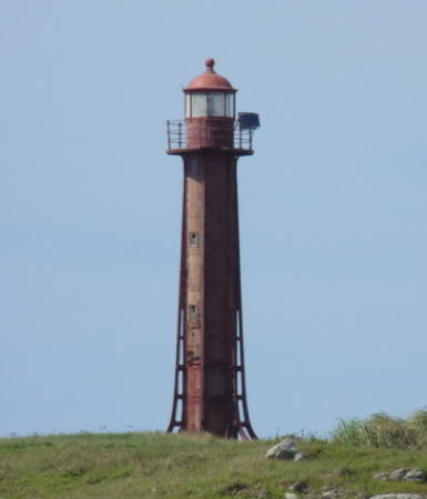
1914. Inactive since 1999. 13 m (43 ft) round cylindrical cast iron tower with lantern and gallery, painted white with a red band at the base; lantern roof is red. Google's 2024 street view is above, Tchesco Marcondes has a 2014 photo, José Lázaro posted a 2013 photo, and Google also has satellite view. An older (2005) photo shows traces of the former daymark, red and white horizontal bands. This lighthouse, a typical French cast iron tourelle, was originally built on the north side of the Rio Cricaré, also called the Rio São Mateus. Formerly in poor condition, the lighthouse was beautifully restored sometime in 2005-07 and repainted in 2013. The tower iis now in need of a new restoration or at least a repainting. The river's mouth has moved southward and the light has been moved to a modern fiberglass tower on the south side of the river (next entry). Located near the south end of the beachfront of Conceição da Barra. Site open, tower closed. ARLHS BRA-192; ex-Admiralty G0312.
[São Mateus (Conceição da Barra) (2)]
1999. Active; focal plane 14 m (46 ft); two white flashes every 15 s. 11 m (36 ft) round fiberglass tower on a small platform. Lighthouse colored with red and white horizontal bands. George P. Peluch has a closeup 2024 photo, Wallace Pereira Nunes has a 2016 photo, and Google has a satellite view. Located on a dune south of the mouth of the Rio Cricaré, also called the Rio São Mateus. Site open, tower closed. BR-1852; Admiralty G0312; NGA 18213.

Regência Lighthouses
Suçuraca (2)
2002. Active; focal plane 64 m (210 ft); two white flashes, separated by 9 s, every 30 s. 40 m (131 ft) square cylindrical concrete tower, painted white with one broad black horizontal band. A 2024 photo is at right, a 2018 photo is available, Marcio Baldi has a 2017 photo, and Google has a satellite view. A sibling of Rio Doce (2). A 2002 Brazilian Navy notice to mariners indicates this tower replaced a light with a focal plane of only 24 m (80 ft). Located about 55 km (35 mi) north of Regência. Site status unknown. ARLHS BRA-247; BR-1854; Admiralty G0313.5; NGA 18214.
*** Rio Doce (Regência) (1)
1895. Inactive since 1994. Originally this was a 34 m (112 ft) octagonal cast iron skeletal tower with central cylinder. In 1997 the lighthouse was demolished but the lantern, lens, and 2-story watch room were relocated in front of the Museu Histórico de Regência. Lighthouse painted red, lantern roof white. A 2021 photo is below right, a closeup photo is available, Critina Araujo Trancoso also has a good photo, and Google has a satellite view. The lighthouse was first built on the east side of the entrance to the Rio Doce, but was relocated to the west side in 1907. Site and tower open. Owner/site manager: Museu Histórico de Regência . ARLHS BRA-272.

Suçuraca Light,Suçuraca, November 2024
Google photo by Sig. Martelletti
* Rio Doce (Regência) (2)
1997. Active; focal plane approx. 50 m (164 ft); white flash every 6 s. Approx. 40 m (131 ft) square cylindrical concrete tower, painted white with one broad red horizontal band. Andrison Cosme has a 2020 photo, Leandros Moreira has a good photo, and Google has a 2023 street view and a satellite view. Built on one side of the concrete foundation pad of the original lighthouse, on the south side of Regência and the west side of the entrance to the Rio Doce. Site appears to be open, tower closed. ARLHS BRA-088; BR-1860; Admiralty G0316; NGA 18216.
* Barra do Riacho (2)
Date unknown. Active; focal plane 30 m (98 ft); two white flashes every 10 s. 25 m (82 ft) round steel mast. Google has a 2011 street view and a satellite view. Light lists, including the Brazilian list, describe a 22 m (72 ft) round white concrete tower. Located in the new Portocel seaport near the resort city of Barra do Riacho about 25 km (15 mi) southwest of Regência. Site open, tower closed. ARLHS BRA-011; BR-1868; Admiralty G0316.5; NGA 18228.

Vitória Lighthouses
Vitória, the capital of Espíritu Santo state; has an urban populaion of about 325,000 but a metropolitan population approaching two million. The center of the city occupies two large islands that occupy much of the area of Vitória Bay (also called the Bay of Espirito Santo).

Tubarão Sul (South Breakwater)
Date unknown. Active; focal plane 14 m (46 ft); quick-flashing red light. 10 m (33 ft) round cylindrical fiberglass tower colored with red and white horizontal bands. Trabas has Capt. Peter's 2010 photo, Joel Fabiana has a 2025 view from the sea, and Google has a satellite view. Tubarão is a new port developed on a peninsula on the east side of the bay of Vitória. Located at the end of a breakwater pier at Tubarão. Site and tower closed. BR-1952; Admiralty G0320.4; NGA 18247.
Tubarão Range Rear
Date unknown. Active; focal plane 42 m (138 ft); quick-flashing white light. 16 m (52 ft) round cylindrical fiberglass tower, colored with orange and white horizontal bands. Trabas has a 2010 photo by Capt. Peter and Google has a 2024 street view and a satellite view. The front light is on a similar but much smaller tower on a platform in the water. Located on a hillside park above the beach in Jardim Camburi, at the northeastern corner of the bay. Site status unknown, but there should be a view from the bayside street. BR-1940; Admiralty G0320.2; NGA 18241.

Rio Doce Light, Regência, August 2021
Instagram photo by Terra Capixaba
* Ilha do Boi (Vitória Range Front)
Date unknown. Active; focal plane 70 m (230 ft); continuous light, white, red or green depending on direction. Approx. 60 m (197 ft) tower carrying a disk-shaped water tank. Pedro Ronchi's 2023 photo is at right, Trabas has a 2011 photo by Capt. Peter and Google has a 2019 street view and a satellite view. The light also serves as the front light of a range, the rear light being on a tower on a ridge in the city (next entry). Long since joined to the mainland, the Ilha do Boi is a peninsula on the north side of the harbor entrance to Vitória, the state capital. Located at the eastern tip of the peninsula. Site open, tower closed. BR-1992; Admiralty G0322; NGA 18264.
* Morro Grande (Vitória Range Rear, "Torre Vermelha")
Date unknown. Active; focal plane 208 m (682 ft); white light, 2 s on, 2 s off. Approx. 12 m (39 ft) square skeletal tower with central cylinder, painted white with a red horizontal band. A 2017 photo is available, Trabas has a distant 2011 photo by Capt. Peter, Edson Chagas has a 2018 street view, and Google has a satellite view. Located in a hilltop park about 2.7 km (1.7 mi) west of the front light. Site open, and appparently it is possible to climb the tower. BR-1996; Admiralty G0322.1; NGA 18268.
Pedra da Baleia
Date unknown. Active; focal plane 5 m (16 ft); two white flashes every 6 s. 4 m (13 ft) masonry tower, painted white (previously green). Trabas has Capt. Peter's 2011 photo and Google has a satellite view. A 2024 closeup shows the tower painted white. Located on a rock off the Ponta Santa Luzia. Accessible only by boat. Site open, tower closed. BR-2008; Admiralty G0321; NGA 18252.

Ilha do Boi Light, Vitória, July 2023
Google Maps photo by Pedro Ronchi
** Santa Luzia
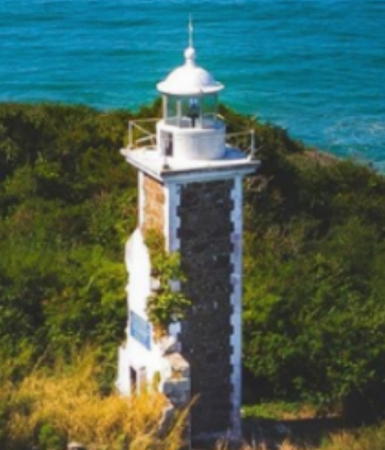
1870. Active; focal plane 29 m (95 ft); four white flashes, separated by 2 s, every 12 s. 12 m (39 ft) octagonal cast iron tower with buttressed base, lantern and gallery, painted white. Milene Klippel's 2024 photo is at the top of this page, Trabas has a 2009 photo by Capt. Hinrichs, Antonio Lobo has a good 2020 photo, another photo is available, Alberto Backes has a 2017 street view, and Google has a satellite view. This is one of nine cast iron lighthouses prefabricated for Brazil by P & W McLellan of Glasgow, Scotland. After being closed for some nine years, this historic tower was reopened to visitors in August 2003. The lighthouse was renovated and repainted in 2019-20. Located on the Ponta Santa Luzia on the south side of the entrance to the Bahia do Espírito Santo and the port of Vitória. Site open; tower open Saturdays, Sundays, and holidays. . ARLHS BRA-095; BR-1980; Admiralty G0320; NGA 18240.
Ilha do Pacotes
Date unknown. Active; focal plane 7 m (23 ft); white flash every 6 s. 4 m (13 ft) masonry tower, painted white. Trabas has Capt. Theo's photo and Google has a satellite view. Located on a rocky reef about 4 km (2.5 mi) southeast of the Santa Luzia lighthouse. Accessible only by boat. Site open, tower closed. BR-1976; Admiralty G0328; NGA 18312.

Guarapari Lighthouses
Ilha Escalvada
1907. Active; focal plane 27 m (89 ft); two quick white flashes every 6 s. 12 m (39 ft) round cylindrical cast iron tower with lantern and gallery, painted red. Súrian Tomich has a 2026 view, 2009 photo is available, Luciano Daniel has a colorized 2009 photo, Cleiton Cassio Bach has a 2021 view, Wikimedia has a distant view from the sea, and Google has a satellite view. Located on a rocky island about 10 km (6 mi) of the coast near Guarapari. Accessible only by boat. ARLHS BRA-033; BR-2088; Admiralty G0330; NGA 18316.
Ilha do Francês (Ilha dos Franceses)
1883. Active; focal plane 48 m (157 ft); white light 2 s on, 13 s off. 12 m (39 ft) square cylindrical stone tower with lantern and gallery. The lighthouse is dark stone with white stone "edges" at the four corners; lantern painted white. The keeper's house, formerly attached, has been demolished, but traces of its wall cling to the tower. Gelson Costa Macedo has the 2020 drone view at right, James Altoé Duarte has a photo, Fabricio Costa has a view from the sea, and Google has a satellite view. Distinctively French in design, the lighthouse in fact was built by French engineers, and they are remembered in the name of the island. Located on an island about 20 miles southwest of Guarapari. Site status unknown. ARLHS BRA-051; BR-2140; Admiralty G0332; NGA 18324.

Ilha Escalvada Light, Guarapari, April 2020
Google Maps photo by Gelson Costa Macedo
Itapemirim (Ilha Branca)
Date unknown. Active; focal plane 5 m (16 ft); white flash every 10 s. 3 m (10 ft) square white concrete tower. There is a closeup of the lighthouse at the 0:21 mark in a 2025 video by Helio Fernandes, Felippe Lascosque has a view from the sea and Google has a satellite view. Located on an islet about 2 km (1.25 mi) off the mouth of the Rio Itapemirim. Accessible only by boat. ARLHS BRA-141; BR-2144; Admiralty G0334; NGA 18328.

Information available on lost lighthouses:

Notable faux lighthouses:

Adjoining pages: North: Bahia | South: Rio de Janeiro

Return to the Lighthouse Directory index | Ratings key

Posted January 30, 2004. Checked and revised October 21, 2026. Lighthouses: 15. Site copyright 2026 Russ Rowlett and the University of North Carolina at Chapel Hill.