Lighthouses of Brazil: Rio de Janeiro

The Federative Republic of Brazil (Brasil in Portuguese), the largest country in South America and fifth largest in the world, has a lengthy coastline, a large number of lighthouses, and a distinguished lighthouse history. Colonized by Portugal, Brazil declared its independence in 1822. Uniquely among American nations it was a monarchy as the Empire of Brazil until 1889.

Brazil is a federal republic with 26 states and a federal district. This page covers the lighthouses of Brazil's east coast in the state of Rio de Janeiro. Of course the state is known especially for its capital, the city of Rio de Janeiro, often called simply Rio. The state has a coast about 635 km (395 mi) long, featuring beautiful sandy beaches framed by steep, often mountainous headlands with a scattering of offshore islands.

The Portuguese word for a lighthouse is farol, plural faróis. In Brazilian use, the word farol generally applies to all light towers, regardless of whether they are enclosed structures or not. The word farolete or farolim is sometimes used for smaller towers. In Portuguese ilha is an island, ilhéu is an islet, cabo is a cape, ponta is a promontory or point of land, rocha is a rock, recife is a reef, baía is a bay, estreito is a strait, rio is a river, and porto is a port or harbor.

Active lighthouses in Brazil are owned by the navy (Marinha do Brasil) and maintained by the Centro de Sinalização Náutica e Reparos Almirante Moraes Rego (CAMR) in the Diretoria de Hidrografia e Navegacão (DHN). Many of the larger lighthouses are staffed by resident keepers or by rotating crews of naval personnel. Only a small number of Brazilian lighthouses are open to the public.

ARLHS numbers are from the ARLHS World List of Lights. BR numbers are from the official Brazilian Lista de Faroís. Admiralty numbers are from volume G of the Admiralty List of Lights & Fog Signals. U.S. NGA numbers are from Publication 110.

General Sources
Faroís Brasileiros
This web site for Brazilian lighthouses has small photos and historical information for many of the major lights.
Online List of Lights - Brazil
Photos by various photographers, posted by Alexander Trabas. Most of the Brazilian photos are by Capt. Theo Hinrichs or Capt. Peter Mosselberger.
Lighthouses in Brazil
Photos by various photographers available from Wikimedia.
World of Lighthouses - Brazil
Photos by various photographers available from Lighthouses.net.
Lista de faróis do Brasil
Index to articles in the Portuguese edition of Wikipedia.
Lista de Faróis
The official Brazilian light list.
Leuchttürme Südamerikas auf historischen Postkarten
Historic postcard views posted by Klaus Huelse.
GPSNauticalCharts
Navigational chart information for Brazil.
Google Maps
Satellite view of the coast..


Ilha Rasa Light, Rio de Janeiro, July 2022
Google Maps photo by Luiz Flavio

São Francisco de Itabapoana Lighthouses
* Barra de Itabapoana (3)
2006 (station establishment date unknown). Active; focal plane 35 m (115 ft); green flash every 6 s. 15 m (49 ft) square cylindrical skeletal tower; the top of the tower also carries a white slatted daymark. Entire lighthouse painted white. Kanneth Lucena has a 2023 photo, Wikimapia has Jaime Azevedo's photo, and Google has a street view and a satellite view. The original light here was a 10 m (33 ft) skeletal tower located near the beach; it may have been damaged in a storm. It was replaced in 2003 by a 6 m (20 ft) fiberglass tower at the current location; probably this light proved to be too short for mariners to see clearly. Located beside the coastal highway, about 60 m (200 ft) southeast of the former lighthouse. Site open, tower closed. ARLHS BRA-117; BR-2146; Admiralty G0335; NGA 18330.
* Ponta do Retiro (1)
Date unknown. Inactive. Approx. 18 m (59 ft) square stone tower. Gooogle has a street view and a satellite view. Nearby buildings may include a former keeper's house. Located near the active lighthouse.
* Ponta do Retiro (2)
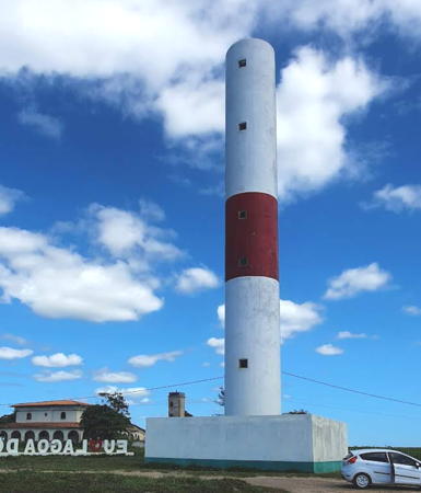
Date unknown (recent). Active; focal plane 40 m (131 ft); three white flashes every 15 s. 30 m (98 ft) round concrete tower, painted white with a red horizontal band. A 2022 photo by Samuel Campos is at right, Douglas Souza has a 2018 photo, Juscelino Veiga also has a 2018 photo, Robson Gomes has a view from the beach, and Google has a street view and a satellite view. Located about 5 km (3 mi) south of Barra de Itabapoana. Site open, tower closed. . ARLHS BRA-235; BR-2146.4; Admiralty G0335.5; NGA 18330.5.
#Guaxindiba (2)
2003(?). Inactive since 2017 and subsequently removed. This was a 20 m (66 ft) square cylindrical skeletal tower carrying a rectangular daymark panel, painted white. Wikimapia has Jaime Azevedo's photo but Google's satellite view confirms the removal. NGA formerly listed a round fiberglass tower, colored with black and white horizontal bands; this light was removed. Note: the São Mateus lighthouse in Conceição da Barra (see above) is also called the Farol de Guaxindiba. Located just off the beach about 5 km (3 mi) east of São Francisco de Itabapoana. Site probably open, tower closed. ARLHS BRA-039; ex-BR-2147; ex-Admiralty G0336; ex-NGA 18331.
* Atafona (São João da Barra) (4)
2007 (station established 1889). Active; focal plane 30 m (98 ft); two white flashes every 15 s. 25 m (82 ft) square cylindrical skeletal tower, painted with black and white horizontal bands. Carlos Adesá has a blog with a photo (halfway down the page) and some historical information, and Google has a street view and a satellite view. The light is named for the Pontal de Atafona, a former seaside resort nearby that is being destroyed by beach erosion. The original light was a cast iron tower. It was replaced by a masonry lighthouse in 1910 and that lighthouse was lost to beach erosion in 1982. The third lighthouse, a skeletal tower, was also demolished when it was endangered by the sea. Located one block off the beach near the north end of São João da Barra, marking the entrance to the Rio Paraíba. Site open, tower closed. ARLHS BRA-008; BR-2148; Admiralty G0338; NGA 18332.

Ponta do Retiro Light, São Francisco de Itabapoana, April 2022
Google Maps photo by Samuel Campos

Campos and Quissamã Lighthouses
* Açu (Barra do Açu) (2)
Date unknown (station established 1948). Active; focal plane 13 m (43 ft); white flash every 3 s. 10 m (33 ft) round cylindrical fiberglass tower painted with black and white horizontal bands. No lantern. Fernando Silva has a 2021 sunset photo and Google has a street view and a satellite view. This tower, typical of many modern Brazilian lights, replaced a masonry lighthouse. Located beside the coastal highway about 7 km (4 mi) northeast of Farol de São Tomé. Site open, tower closed. ARLHS BRA-249; BR-2152; Admiralty G0340; NGA 18336.
**** São Tomé (São Thomé)
1882. Active; focal plane 161 ft; two long (3 s) white flashes, separated by 10.5 s, every 67.5 s. 45 m (148 ft) octagonal pyramidal cast iron skeletal tower with central cylinder, painted red; lantern dome painted white. This lighthouse was designed in France by the firm of Gustave Eiffel and prefabricated by Barbier & Fenestre. Google's 2023 street view is at right, Frederico Rangel Nogueira has a 2017 photo, Liana Siqueira's 2007 photo shows the lighthouse freshly painted, a page for the lighthouse has photos and historical information, Wikimedia has a photo, and Google has a satellite view. Cabo São Tomé is a prominent headland in the northeastern corner of Rio de Janeiro state. However, the lighthouse is not actually on the cape; it is at the end of the Av. Boa Vista in Farol de São Thomé, a town about 30 miles southeast of the city of Campos dos Goytacazes and 7 km (4 mi) southwest of the cape. Site open; tower open in late afternoons daily. . ARLHS BRA-097; BR-2156; Admiralty G0342; NGA 18340.
* Quissamã
Date unknown. Active; focal plane 40 m (131 ft); white light, 2 s on, 2 s off. 40 m (131 ft) round concrete tower painted white with two red horizontal bands in the lower third of the tower. No lantern. Fábio Pezzotti has a 2025 photo, Wikimapia has Jaime Azevedo's photo and Google has a street view from the beach and a satellite view. Clearly endangered by sea level rise. Located on the beach about 25 km (15 mi) southwest of Cabo São Tomé. Site open, tower closed. Site manager: Parque Nacional da Restinga de Jurubatiba. ARLHS BRA-237; BR-2158; Admiralty G0343; NGA 18342.

São Tomé Light, Farol de São Thomé, June 2023
Google Maps street view

Macaé Lighthouses
* [Ponta da Imbetiba (Macaé (1), "Farolito")]
1880 (?). Inactive (since 1902?). Round tower about 3 m (10 ft) tall. Local sources claim this is the ruin of the 1880 beacon. Miranda Wagner has a 2020 photo, Fábio Macahe has a 2014 street view and Google has an indistinct satellite view. Located on the Ponta de Imbetiba, the cape sheltering the waterfront of Macaé. Site open. .
Ilhas de Santana (Macaé (2), Sant'Anna)
1902. Active; focal plane 156 m (512 ft); alternating red and white light, on 2.3 s, off 7.7 s. 16 m (52 ft) square masonry tower with lantern and gallery, painted white, rising from 1-story masonry keeper's house. A 2020 drone view is at right, a 2007 photo is available, Sofia Bravo has a 2018 closeup, the city of Macaé posted a good photo, and Google has a satellite view. Located on the Ilha de Sant'Anna, a rocky island about 11 km (7 mi) southeast of the Ponta da Imbetiba. Accessible only by boat. Site status unknown. ARLHS BRA-062; BR-2160; Admiralty G0346; NGA 18344.

Cabo Frio Lighthouses
* Lajinha (Laginha)
1913. Active; focal plane 49 m (161 ft); red flash every 6 s. 7 m (23 ft) square pyramidal skeletal concrete tower with enclosed lower section. Lighthouse painted white. Thiago Machado has a closeup 2019 photo, a 2018 photo is available, and Google has a satellite view. Located on a promontory just east of the beaches of Cabo Frio; accessible by a hiking trail. The location is known for its spectacular view. Site open, tower closed. . BR-2200; Admiralty G0350; NGA 18356.

Macaé Light, Ilha de Sant'Anna, Macaé, January 2020
Google Maps photo by Wander Maps !
Cabo Frio (1)
1836(?). Inactive since 1862(?). Ruins of the original round stone lighthouse. Peterson da Silva has a 2016 closeup photo, Renato Santos has another closeup photo, and Bing has a satellite view. Some sources give 1833 as the date for this lighthouse. The Ilha de Cabo Frio, an island just off the mainland, marks a right-angle turn in the coast about 80 miles east of Rio de Janeiro. The cape is a notoriously dangerous place for ships. Built on the highest point of the island at an elevation of about 390 m (1275 ft), the lighthouse was abandoned because it was too high for its light to be seen in foggy weather. It was replaced in 1862 (some sources say 1866) by a 16 m (52 ft) stone tower near the location of the present light (next entry) but higher, with a focal plane of 159 m (522 ft). The island is accessible by boat from Arraial do Cabo on the mainland, but permits from the navy's research institute, the Instituto de Estudos do Mar Almirante Paulo Moreira, are required (apply at the institute's museum, the Museu Oceanográfico, in Arraial do Cabo). The lighthouse is reached by a steep and difficult trail. Site and tower open. ARLHS BRA-269.
Cabo Frio (3)
1925. Active; focal plane 144 m (472 ft); white light, 1.2 s on, 8.8 s off. 16 m (52 ft) round cast iron tower rising from a 1-story keeper's quarters. Entire light station painted white. Staffed light station. Renato Santos has the 2022 photo at right, has Capt. Peter's 2024 closeup, Torsten Moltrecht has a fine 2018 photo, Rodrigo Wallas has a closeup, Wikimedia has a distant view from the sea, and Google has a satellite view. The light station is perched on the steep bluff rising from the sea at the point of the cape, on the southern tip of the island. Site and tower closed. ARLHS BRA-018; BR-2400; Admiralty G0352; NGA 18360.

Cabo Frio Light, Arraial do Cabo, May 2022
Google Maps photo by Renato Santos

Rio de Janeiro Lighthouses
One of the most famous and most visited cities of the Americas, Rio de Janeiro was the capital of Brazil until the capital moved inland to Brasília in 1960. The city faces south on the Atlantic Ocean and east on Guanabara Bay, a magnificent natural harbor. The city has a population of about 7 million with a metropolitan population of about 12.5 million. The city's name ("River of January") was given by the bay's European discoverer Gaspar de Lemos, whose ship entered the bay on New Year's Day 1502.

*
Ponta Negra (2)
Date unknown (station established 1909). Active; focal plane 71 m (233 ft); two white flashes every 10 s. 11 m (36 ft) round cylindrical white concrete tower, rising from a square 1-story concrete equipment building. Entire lighthouse painted white. Ricardo Lugão Pereira has a photo, another closeup photo is available, and Google has a street view and a satellite view. This is popular mirante (viewpoint). Located on a rocky headland about 13 km (8 mi) southeast of Maricá and 40 km (25 mi) east of the Baía de Guanabara entrance. Accessible by road. Site open, tower closed. . ARLHS BRA-080; BR-2412; Admiralty G0356; NGA 18364.
Ilhas Maricás
Date unknown (station established 1916). Active; focal plane 80 m (262 ft); one long (2 s) white flash every 15 s. 10 m (33 ft) round cylindrical concrete tower with gallery and a small lantern, painted white with one black horizontal band. Elihofni Lima's 2025 drone view is at right, Washington Portela da Silva has a closeup 2024 photo, Trabas has Capt. Peter Mosselberger's distant 2006 photo, and Google has a satellite view. Located atop an island about 15 km (9 mi) southeast of the entrance to the Baía de Guanabara, the harbor of Rio de Janeiro. Accessible only by boat. Site and tower closed. ARLHS BRA-046; BR-2416; Admiralty G0358; NGA 18368.
Ilha Rasa
1829. Active; focal plane 101 m (331 ft); flash every 5 s, two white and then one red. 26 m (85 ft) round cylindrical stone tower with lantern and gallery, centered on a 3-story stone keeper's quarters; very rare meso-radial Soutter et Lemunier Fresnel lens (1883). Lighthouse painted white with brown trim; lantern is all white. Jéssica Germano's 2022 photo is at the top of this page, Faroís Brasileiros has a page for the lighthouse, a 2020 photo and another closeup are available, Trabas has Bjørn Poulsen's 2013 photo, Larry Myhre has a distant view, and Google has a satellite view. This is a famous lighthouse, Brazil's oldest, and an outstanding example of Brazilian colonial-style architecture. The light station is staffed by a crew of four with 3-month tours of duty. The lens is one of only two meso-radial lenses known to have been produced; these lenses are larger than 1st order but smaller than the great hyper-radial lenses. The powerful light has a range of 45 nautical miles (83 km or 51.8 mi). The lighthouse was designed and built by João de Souza Pacheco Leitão. Construction began in 1819 but inauguration of the lighthouse was delayed when the optics, ordered from France, were stolen en route by pirates. A 1st order lens was installed in 1883 and at the same time the lighthouse became the first in South America to be electrified. The meso-radial lens was installed in 1909. Since 1951 it has been powered by diesel-fueled generators. Located on an island about 11 km (7 mi) off the entrance to the Baía de Guanabara, the harbor of Rio de Janeiro. Accessible only by boat. Site and tower closed (the entire island is a Brazilian Navy base); the lighthouse can be seen distantly from the Ipanema beach. . ARLHS BRA-047; BR-2420; Admiralty G0360; NGA 18372.

Ilhas Maricás Light, Rio de Janeiro, January 2025
Google Maps photo by Elihofni Lima
* Fortaleza de Santa Cruz
1839. Active; focal plane 26 m (85 ft); red light, 1 s on, 1 s off. 6 m (20 ft) square stone tower with lantern, mounted atop the center of the fort. The modern light is mounted on a short post atop the lantern. Halley Pacheco de Oliveira has a 2011 photo, Nelson Calmon has a good photo, Trabas has Erich Hartmann's 2018 photo, Wikimedia has several photos, Rafael D. E. Borborema has a street view, Leandro Moreira's panoramic view of the fort shows the location of the light tower, and Google has a satellite view. Built in the late 1500s, the fort guards the east side of the entrance to the harbor of Rio de Janeiro, in Niterói. Site open, fort open, tower closed. ARLHS BRA-094; BR-2432; Admiralty G0367; NGA 18380.
Ilha de Laje
Date unknown. Active; focal plane 17 m (56 ft); green light, 1 s on, 1 s off. 10 m (33 ft) square pyramidal concrete tower, painted green. Trabas has Erich Hartmann's 2018 photo and Google has a 2021 street view and a satellite view. The tiny island of Laje is almost completely covered by a fort. Located at the east end of the islet, in the entrance to the harbor of Rio de Janeiro. Accessible only by boat. Site status unknown. ARLHS BRA-145; BR-2436; Admiralty G0368; NGA 18384.
* Ponta da Armação
Date unknown. Active; focal plane 21 m (69 ft); white flash every 10 s. 19 m (62 ft) square concrete tower, painted with black and white horizontal bands. Celso Marino's 2019 photo is at right, Lightphotos.net has a photo, and Google has a satellite view. Located in the CAMR headquarters on the southeastern tip of the Ponta D'Areia peninsula in Niterói, on the east side of the harbor of Rio de Janeiro. Site open, tower closed. ARLHS BRA-168; BR-2450; Admiralty G0382.25; NGA 18413.
Itapacis
Date unknown. Active; focal plane 10 m (33 ft); red flash every 3 s. 7 m (23 ft) round cylindrical red concrete tower. Andre Luiz Andrade has a view from the bay, André Madeira has a view from a different angle, and Google has a satellite view. Located at the west end of a small island in in the upper portion of the Baía de Guanabara, a short distance south of the Ilha da Paqueta (next entry). Accessible only by boat. Site status unknown. BR-2520; Admiralty G0396; NGA 18452.
* [Ilha da Paquetá (Ponta da Rabeira)]
Date unknown. Active; focal plane 14 m (46 ft); green flash every 16 s. 11 m (36 ft) square cylindrical masonry clock tower, painted white. Trabas has Alfonso Biescas Vignau's 2024 photo, Wikimedia has Sebástian Freire's photo and Google has a street view and a satellite view. Located on a pier on the east side of the Ilha da Paquetá, an island of upscale homes in the upper portion of the Baía de Guanabara. Accessible only by boat. Site open, tower closed. BR-2522; Admiralty G0398; NGA 18452.5.

Ponta da Armação Light, Rio de Janeiro, October 2019
Google Maps photo by HCelso Marino
Xaréu
Date unknown. Active; focal plane 11 m (36 ft); two white flashes every 5 s. 9 m (30 ft) round cylindrical concrete tower painted black with one red horizontal band. No photo available and Google has only a fuzzy satellite view. Located on a rock on the west side of the main channel in the upper portion of the Baía de Guanabara. Accessible only by boat. Site open, tower closed. BR-2508; Admiralty G0392; NGA 18444.
Parcel das Feiticeiras
Date unknown. Active; focal plane 9 m (30 ft); two white flashes every 10 s. 9 m (30 ft) round cylindrical tower painted with black and red horizontal bands. Trabas has Erich Hartmann's 2018 photo and Google has an indistinct satellite view. Located on a shoal off the Ilha de Enxadas, an islet on the west side of the Baía de Guanabara. Accessible only by boat. Site open, tower closed. BR-2688; Admiralty G0376; NGA 18404.
Ilha de Villegagnon
Date unknown. Active; focal plane 7 m (23 ft); white flash every 6 s. 7 m (23 ft) square pyramidal concrete tower, painted white with a green horizontal band. Trabas has Erich Hartmann's 2018 photo and Google has a satellite view. The island of Villegagnon, on the west side of the Baía de Guanabara, is the site of the Brazilian Naval Academy (Escola Naval). Located at the northeast end of the island. Site status unknown. BR-2444; Admiralty G0372; NGA 18388.
Ilha Rasa da Guaratiba
Date unknown. Active; focal plane 42 m (138 ft); white flash every 6 s. 8 m (26 ft) square cylindrical white concrete tower. R.J. Flavio has the photo at right and a closeu, Torsten Moltrecht has a distant aerial view and Google has a satellite view. Located on an island off the Ponta da Guaratiba, a cape about 40 km (25 mi) west of the entrance to Rio de Janeiro harbor. Accessible only by boat. Site status unknown. ARLHS BRA-134; BR-2704; Admiralty G0404; NGA 18460.
Laje da Marambaia
Date unknown. Active; focal plane 24 m (79 ft); two white flashes every 10 s. 7 m (23 ft) square pyamidal stone tower painted black with one red horizontal band. No photo available but Bing has a satellite view. Located on a rock off the Ilha de Marambaia about 80 km (50 mi) west of the entrance to Rio de Janeiro harbor. Accessible only by boat. Site status unknown. ARLHS BRA-151; BR-2712; Admiralty G0406; NGA 18468.

Ilha Rasa da Guaratiba Light, January 2018
Google Maps photo by R.J. Flavio

Ilha Grande Area Lighthouses
Ponta de Castelhanos (Farol dos Castelhanos)
1901. Active; focal plane 121 m (397 ft); white light, on 6 s, then two flashes during the next 4 s. 16 m (52 ft) square pyramidal masonry (stone?) tower rising from 1-story masonry keeper's quarters. Entire structure painted white; roofs are red. Staffed station. A 2023 photo is at right, a 2018 closeup is available, Gilberto Amaral Pereira has an aerial view, Trabas has Capt. Peter's distant 2005 view, Julio Cardoso has a sunrise view, and Google has a satellite view. Sibling of the Ponta do Boi lighthouse (see below). Located at the eastern end of the Ilha Grande, a large island readily accessible by ferry from Angra dos Reis or Mangaratiba on the mainland, roughly 120 km (75 mi) west of Rio de Janeiro. All of the island is under environmental protection and most of it is set aside as a state park. Site open and accessible by hiking trail; the keeper will sometimes conduct tours of the tower. ARLHS BRA-076; BR-2716; Admiralty G0408; NGA 18472
Juatinga
Date unknown. Active; focal plane 175 m (574 ft); white flash every 10 s. 8 m (26 ft) square pyramidal white concrete tower. Bruno Santoro has a closeup photo of a group of schoolkids who hiked to the lighthouse, Gustavo Santos also has a closeup photo, and Google has a satellite view. This light enjoys a spectacular view of the Atlantic and is a popular destination for hikers in the Juatinga Ecological Reserve. Located at the tip of the peninsula on the west side of the entrance to the Bahia de Ilha Grande. Accessible by a hiking trail. Site open and nothing prevents visitors from climbing the external ladder of the tower. Site manager: Reserva Ecológica de Juatinga. BR-3156; Admiralty G0458; NGA 18556.

Ponta dos Castelhanos Light, Ilha Grande, December 2023
Google Maps photo by Felipe

Information available on lost lighthouses:

Notable faux lighthouses:

Adjoining pages: North: Espirito Santo | South: Southeastern Brazil

Return to the Lighthouse Directory index | Ratings key

Posted January 30, 2004. Checked and revised August 19, 2025. Lighthouses: 26. Site copyright 2025 Russ Rowlett and the University of North Carolina at Chapel Hill.