Lighthouses of Spain: Eastern Canary Islands

The Kingdom of Spain occupies nearly 85% of the Iberian Peninsula in southeastern Europe with coastlines facing south and southeast on the Mediterranean Sea and northwest on the Atlantic Ocean. Spain also includes the Balearic Islands in the Mediterranean, the Canary Islands in the Atlantic, and the cities of Ceuta and Melilla on the north coast of Morocco.

The Canary Islands (Canarias in Spanish) are a group of seven volcanic islands located west of the southern coast of Morocco. The islands have been known to Europeans since antiquity; they were inhabited by people related to the Berbers of North Africa before being conquered by Spain during the fifteenth century. They have been Spanish territory ever since.

Since 1978 Spain has been divided into 17 regions called autonomous communities (comunidads autónoma) that have been granted varying degrees of autonomy by the central government. The Canary Islands form one of the autonomous regions, divided into two provinces. This page includes the lighthouses of the eastern province of Las Palmas de Gran Canaria, including the islands of Gran Canaria, Fuerteventura, and Lanzarote. Lighthouses of the western province of Santa Cruz de Tenerife, including the islands of La Palma, El Hierro, La Gomera, and Tenerife, are described on the Western Canary Islands page.

Located almost in the tropics, the islands are very popular tourist destinations. In case you were wondering, the islands are not named for canary birds; the birds (Serinus canaria) are named for the islands.

The word for a lighthouse is faro in Spanish but its use is generally restricted to the larger coastal light stations. Smaller lighthouses are called balizas (beacons). In Spanish isla is an island, cabo is a cape, punta is a promontory or point of land, péñon is a rock, arrecife is a reef, bahía is a bay, ría is an estuary or inlet, estrecho is a strait, río is a river, and puerto is a port or harbor.

The navigational lights in Spain are the responsibility of the national port authority, Puertos del Estado, but generally they are operated and maintained by regional port authorities. In the Canaries, each of the two provinces has its own port authority, respectively the Autoridad Portuaria de Santa Cruz de Tenerife and the Autoridad Portuaria de Las Palmas de Gran Canaria.

ARLHS numbers are from the ARLHS World List of Lights. ES numbers are from the Spanish national list of lights, Libro de Faros. Admiralty numbers are from volume D of the Admiralty List of Lights & Fog Signals. U.S. NGA numbers are from Publication 113.

General Sources
Faros y Señales de Niebla
Online edition of the official Spanish light list.
Online List of Lights - Islas Canarias
Photos by various photographers posted by Alexander Trabas.
Lighthouses in the Canary Islands
Photos by various photographers available from Wikimedia.
World of Lighthouses - Non-continental Spain
Photos by various photographers available from Lightphotos.net.
Phares d'Afrique
This page, part of Le phare à travers le monde, the web site of Alain Guyomard and Robert Carceller, links to fine photos of many lighthouses of the Canaries.
Anexo: Faros de España
List of Spanish lighthouses with links to articles in the Spanish language Wikipedia.
Spanische Leuchttürme auf historischen Postkarten
Historic postcard images posted by Klaus Huelse.
GPSNavigationCharts
Navigation chart information for the Canary Islands.
Google Maps
Satellite view of the Canary Islands.

Arinaga Light, Gran Canaria, January 2024
Google Maps photo by Sven Tamme
Northern Isla de Gran Canaria Lighthouses
Gran Canaria, the third largest and second most populous of the islands, is located in the center of the group. The island is approximately circular with a diameter of about 50 km (30 mi) and has a population of about 865,000.

*
Punta Sardina (2)
1985 (station established 1891). Active; focal plane 47 m (154 ft); four white flashes every 20 s. 24 m (79 ft) round cylindrical masonry tower with lantern and double gallery. Lighthouse painted white with horizontal red bands below the galleries; lantern dome is unpainted gray metal. A 2024 photo is at right, Juan Francisco Marrero has a good photo, Trabas has Eckhard Meyer's 2018 closeup, Lightphotos.net has a photo, Toni Teror has a good 2010 photo, and Google has a street view and a satellite view. The original lighthouse was suddenly destroyed in 1986, to the horror of preservationists, after municipal authorities had already identified it as a site of cultural importance. Located at the northwestern corner of the island, about 2 km (1.2 mi) northwest of the town of Sardina. Accessible by road. Site open, tower closed. . ARLHS CAI-055; ES-12610; Admiralty D2816; NGA 23928.
La Isleta (2)
Date unknown (station established 1865). Active; focal plane 249 m (817 ft); four white flashes, in a 1+3 pattern, every 20 s. 10 m (33 ft) round cylindrical masonry tower with lantern and gallery mounted atop a 2-story keeper's house; the total height of the structure must be more than 10 m. Building painted white; gallery rail painted yellow. Juan Manuel González has a 2013 photo, Trabas has a distant 2007 photo, Wikimedia has a view from the sea, and Google has a satellite view. This is Spain's highest active lighthouse; NGA lists it with a range of 39 km (24 mi). La Isleta is a peninsula extending northward from the city of Las Palmas; it has the form of an island attached by a narrow isthmus. Located atop the crater rim of a dormant volcanic dome about 2.5 km (1.5 mi) north of the harbor of Las Palmas de Gran Canaria, at the northeastern corner of the island. Site and tower closed (military base area). ARLHS CAI-008; ES-12230; Admiralty D2798; NGA 23932.
Las Palmas Dique de Léon y Castillo (Muelle León y Castillo, Dique del Generalissimo Franco)
Date unknown. Active; focal plane 17 m (56 ft); three green flashes every 12 s. 9 m (30 ft) octagonal stone tower; dark stone alternates with painted white horizontal bands. There is a small gallery, but no lantern. Trabas has a 2016 photo by Rainer Arndt, C.W. Bash also has a photo, and Google has a satellite view. This light is on the mole at the southern end of the container ship terminal of Puerto de la Luz, the main harbor of Las Palmas de Gran Canaria. The pier was named originally for Generalissimo Francisco Franco, who was the governor of the Canary Islands before he became dictator of Spain. The name has been changed to Muelle León y Castillo. Site status unknown. ARLHS CAI-060; ES-12300; Admiralty D2801.2; NGA 23956.

Punta Sardina Light, Gran Canaria, June 2024
Instgram photo by Viaja con Héctor
* Punta de Melenara (Taliarte)
1905. Active; focal plane 33 m (108 ft); two flashes every 10 s, white or red depending on direction. 17 m (56 ft) round cylindrical masonry tower with lantern and double gallery. Entire lighthouse painted white. Martin Kašík's 2021 photo is at right, Trabas has a 2019 photo, Jaime Hernandez Barrera has a closeup photo, and Google has a street view and a satellite view. This lighthouse marks a prominent cape on the east side of the island; white flashes are shown for southbound ships and red flashes for northbound ships. Located about 4 km (2.5 mi) southeast of Telde. Site open, tower closed. . ARLHS CAI-057; ES-12445; Admiralty D2807.5; NGA 23990.

Southern Isla de Gran Canaria Lighthouses
** Arinaga (Punta de Arinaga) (1)
1897. Inactive since 1964. 6 m (20 ft), round cylindrical stone tower with lantern attached to the front of a 1-story masonry keeper's house. Marc Ryckaert's photo is at right. This historic lighthouse was restored in the late 2000s. Pedro Afonso's 2006 photo shows it almost in ruins, with no lantern. A 2008 photo by David Béjar Suárez shows the restoration in progress, and a 2011 photo shows the restored lighthouse equipped with a lantern of modern design. Wikimedia has a 2015 drone view and Manuel J. Arencibia Jimenez has a 2019 closeup. A restaurant opened in the building in August 2016. Site open, tower closed. Site manager: Restaurante Faro de Arinaga . ARLHS CAI-082.
#Arinaga (Punta de Arinaga) (2)
1964 (station established 1897). Inactive since 1984 and demolished in 2008. Approx. 9 m (30 ft) round concrete tower with gallery, adjacent to one end of the original keeper's house. This tower, seen behind the original lighthouse in Pedro Afonso's 2006 photo ,was demolished in the restoration of the historic lighthouse. Site open, tower closed. ARLHS CAI-062.
* Arinaga (Punta de Arinaga) (3)
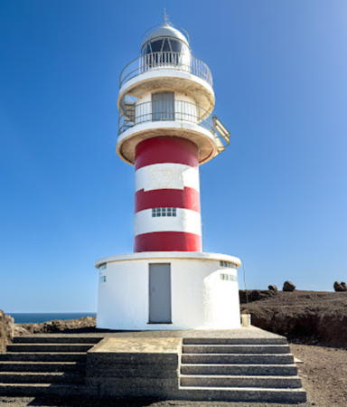
1984 (station established 1897). Active; focal plane 47 m (154 ft); three flashes every 10 s, white or red depending on direction. 14 m (46 ft) round cylindrical masonry tower with lantern and double gallery. Lighthouse painted white with horizontal red bands below the galleries. Sven Tamme's 2024 photo is at the top of this page, a 2015 drone view shows both surviving lighthouses, a closeup photo is available, Trabas has a 2019 photo, Wikimedia has a photo, Lightphotos.net has a closeup, and Google has a street view and a satellite view of the station. Located on a promontory at Playa de Arinaga, on the southeast coast of the island. Site open, tower closed. . ARLHS CAI-024; ES-12510; Admiralty D2812; NGA 24008.

Punta de Melenara (Taliarte) Light, Gran Canaria, December 2021
Google Maps photo by Martin Kašík
* Maspalomas
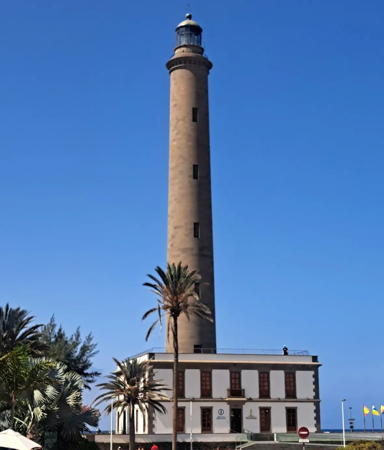
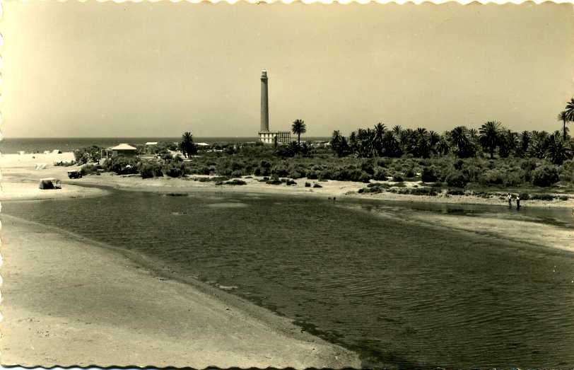
1890. Active; focal plane 60 m (197 ft); three white flashes, in a 1+2 pattern, every 13 s. 56 m (184 ft) round stone tower with lantern and gallery, attached to one corner of a 2-story keeper's house. The lighthouse is unpainted blue-gray stone; keeper's house painted white with unpainted stone trim. A 2024 photo by Dariusz Burkwicz is at right, Trabas has a 2019 photo, Wikimedia has numerous photos, Michael Dicks has a 2021 photo, Huelse has a postcard photo, and Google has a street view and a satellite view. This great lighthouse (third tallest in Spain) marks the southern tip of the Isla de Gran Canaria and is one of the island's best known tourist attractions. Resorts surround the lighthouse but just to the east an area of sand dunes interspersed with wetlands is a protected nature reserve. Located about 4 km (2.5 mi) south of the town of Maspalomas. Site open, tower closed. . ARLHS CAI-018; ES-12520; Admiralty D2814; NGA 24012.
** Puerto Rico West Breakwater (2)
Date unknown. Active; focal plane 11 m (36 ft); two quick red flashes every 4 s. 10 m (33 ft) post light surrounded by a square skeletal tower supporting a spiral stairway, attached to a small 2-story building. Trabas has Hartmut Knape's 2021 photo and Google has a street view and a satellite view. The original light was a 4 m (13 ft) masonry tower. Located at the end of the west breakwater at a pleasure craft marina in Puerto Rico, about 25 km (15 mi) northwest of Maspalomas. Accessible by walking the pier. Site open, and there doesn't appear to be any obstacle to climbing the tower. ES-12580; Admiralty D2815.7; NGA 24022.
* Puerto de Mogán
Date unknown (modern). Active; focal plane 13 m (43 ft); three red flashes every 8.5 s. 6 m (20 ft) trapezoidal tower mounted on the flat roof of a circular 1-story restaurant. Building and tower painted white, but there are narrow red horizontal bands around the lower half of the tower, and the lantern roof is also red. Trabas has a 2019 photo, a 2022 photo is available, and Google has a street view and a satellite view. Located at the end of the breakwater at Puerto de Mogán, one of the few protected harbors on the southwestern coast of Gran Canaria. Site and restaurant open, tower closed. Site manager: Restaurante El Faro de Mogán . ARLHS CAI-061; ES-12600; Admiralty D2815.96; NGA 24023.
* Punta del Castillete
1996. Active; focal plane 114 m (374 ft); white flash every 5 s. 21 m (69 ft) square cylindrical tower with three galleries but no lantern, mounted on a 2-story square base; access to the galleries is by an external stairway that winds around the tower. One of the galleries extends to support a radar antenna. Lighthouse painted with blue and white horizontal bands. Trabas has a closeup 2019 photo, another closeup photo is available, Wikimedia has a photo, and Google has a satellite view. This somewhat ungainly modern lighthouse marks the southwestern corner of the island. Located atop a steep hill just northwest of Puerto de Mogán; accessible by by a stiff climb from the marina. Site open, tower closed. ARLHS CAI-006; ES-12607; Admiralty D2815.94; NGA 24023.7.

Maspalomas Light, Gran Canaria, June 2024
Instagram photo by Dariusz Burkwicz

Isla de Fuerteventura West Coast Lighthouses
Fuerteventura is the Canary Island closest to the mainland of Africa, lying barely 80 km (50 mi) west northwest of Cape Juby in southern Morocco. The second largest of the islands, Fuerteventura is about 100 km (60 mi) long and up to 31 km (20 mi) wide; it has a population of about 125,000.

*
Punta Jandía
1864. Active; focal plane 33 m (108 ft); white flash every 4 s. 19 m (62 ft) round concrete tower with lantern and gallery, attached to a 1-story keeper's house. The lighthouse is unpainted stone; keeper's house painted white with unpainted stone trim; the lantern is all glass, even the dome. Sandro Travaglini's 2022 photo is at right, Trabas has a 2012 closeup, Lightphotos.net has a photo, Guyomard and Carceller have posted a photo by Eric Valenne, another good photo is available, and Google has a satellite view. Caution: the name "Faro de Jandía" is often applied to the Morro Jable lighthouse (see below). Located at the end of a barren peninsula at the extreme southwestern tip of the island; accessible by 4WD. Site open, tower closed. . ARLHS CAI-040; ES-12210; Admiralty D2790; NGA 24024.
* Punta Pesebre
Date unknown. Active; focal plane 10 m (33 ft); white light occulting twice every 6 s. 5 m (16 ft) square equipment room with the light mounted on a bracket on the front. Carlos Buendía has a closeup photo, Trabas has a 2007 closeup, Robert Wróblewski has a street view, and Google has a satellite view. Located on the northern tip of the peninsula at the extreme southwestern end of the island; accessible by 4WD. Site open, tower closed. . ARLHS CAI-067; ES-12212; Admiralty D2791; NGA 24026.

Punta Jandía Light, Fuerteventura, January 2022
Google Maps photo
by Sandro Travaglini
 
* Tostón (Punta de la Ballena) (1)
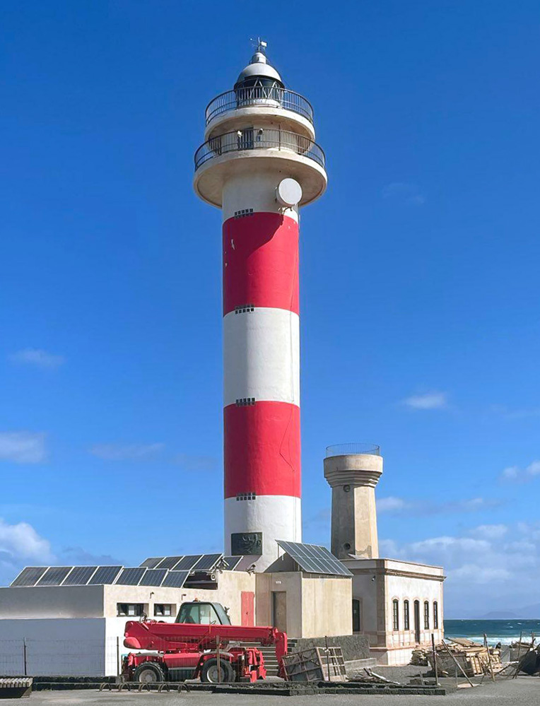
1897. Inactive since the 1950s. 7 m (23 ft) round cylindrical stone tower with lantern and gallery, attached to a 1-story masonry keeper's house. Like the Arinaga lighthouse (see above), the lighthouse has been restored, apparently in 2006. Alex Castellá's 2005 photo and Guyomard and Carceller's photos by Eric Valenne show the old lighthouse before restoration. Lukáš Vápeník's 2022 photo at right shows the restored lighthouse, and Adrian Booth has a 2019 street view. The building is now occupied by the Museo de la Pesca Tradicional, a museum devoted to traditional fisheries of the islands. ARLHS CAI-088.
* Tostón (Punta de la Ballena) (2)
1950s (station established 1897). Inactive since about 1986. Approx. 15 m (49 ft) octagonal concrete tower with gallery, unpainted; lantern removed. Lukáš Vápeník's 2022 photo is at right and Trabas has Eckhard Meyer's 2017 photo. ARLHS CAI-087.
* Tostón (Punta de la Ballena) (3)
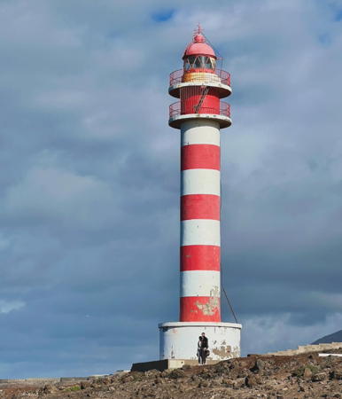
1986(?) (station established 1897). Active; focal plane 35 m (115 ft); white flash every 8 s. 30 m (98 ft) round cylindrical concrete tower with lantern and double gallery. Lighthouse painted white with horizontal red bands below the galleries; lantern dome is metallic gray. Lukáš Vápeník's 2022 photo is at right, another good closeup is available, Trabas has Eckhard Meyer's 2017 photo, Wikimedia has Alex Castellá's 2005 photo and numerous other photos, and Google has a 2018 street view and a good satellite view of the station. Located on the northwestern corner of Fuerteventura, about 4 km (2.5 mi) north of El Cotillo. Site open, tower closed. . ARLHS CAI-058; ES-12220; Admiralty D2792; NGA 24040.
Punta Martiño (Islote de Lobos)
1865. Active; focal plane 29 m (95 ft); two white flashes every 15 s. 7 m (23 ft) square cylindrical stone tower with lantern and gallery, attached to the front of a 1-story stone keeper's house. Tower unpainted; building painted white with stone trim; lantern is metallic gray. Antonio Martos Fernández has a good street view, Nuria Martínez has a 2020 closeup photo, Trabas has a distant 2007 view, and Google has a satellite view. The Isla (or Islote) de Lobos is a 468 ha (1160 acre) island located off the northeastern tip of Fuerteventura. The entire island has been protected since 1982 as a nature preserve, but most of it is open to visitors. Boat transportation is available from Corralejo on the north coast of Fuerteventura. Located on the northeastern tip of the island, marking the south side of the Bocaina Channel separating Fuerteventura from Lanzarote. Site open, tower closed. Site manager: Parque Natural Islote de Lobos. . ARLHS CAI-005; ES-12140; Admiralty D2786; NGA 24044.

Tostón Lights, Fuerteventura, August 2022
Google Maps photo by Lukáš Vápeník

Isla de Fuerteventura East Coast Lighthouses
* Punta Gavioto (Puerto del Rosario)
1992. Active; focal plane 48 m (157 ft); white flash every 5 s. 43 m (141 ft) round cylindrical concrete tower with lantern and gallery, rising from a 1-story circular base. The lighthouse is unpainted white concrete; lantern dome is gray metallic. J. Manganell has a photo, Xito Iglesias has a photo, Trabas has a 2012 closeup, Lightphotos.net has a photo, and Google has a street view and a satellite view. This is the landfall light for Puerto del Rosario, the principal town and port of the Isla de Fuerteventura. Located on the Punta Gaviota on the east side of Puerto del Rosario. Site open, tower closed. . ARLHS CAI-064; ES-12165; Admiralty D2793.5; NGA 24034.
Puerto del Rosario Breakwater
Date unknown. Actove; focal plane 14 m (46 ft); green flash every 5 s. 10 m (33 ft) round barbell-shped tower colored green with a white base. Trabas has Erich Hartmann's 2023 photo and Google has a satellite view. Located at the end of the breakwater mole of Puerto del Rosario. Site and tower closed. ES-12170; Admiralty D2794; NGA 24036.
* Punta La Entellada (Punta Lantailla)
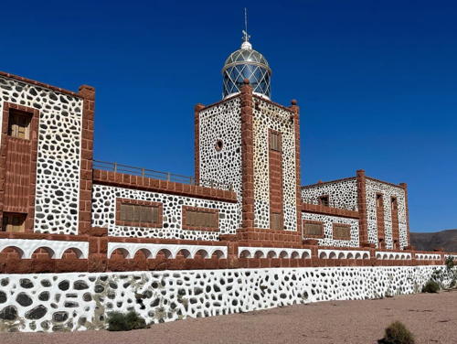
1954. Active; focal plane 196 m (643 ft); three white flashes, in a 2+1 pattern, every 18 s. 12 m (39 ft) square cylindrical rubblestone tower with lantern, rising from a U-shaped 1- and 2-story keeper's complex. This lighthouse has a striking appearance, being built of dark brown stones cemented together with a white mortar; the lantern is all glass, even the dome. A 2024 photo is at right, Trabas has a 2014 photo, Guyomard and Carceller have photos by Eric Valenne, Paweł Morawski has a 2021 photo, Wikimedia has numerous photos, and Google has a street view and a satellite view. Located about 6 km (3.5 mi) east of Las Playitas on the southeast coast of the island. Site open, tower closed. . ARLHS CAI-041; ES-12190; Admiralty D2795; NGA 24032.

Punta la Entallada Light, Fuerteventura, February 2024
Instagram photo
by Katrin & Frank
* Gran Tarajal Dique Extremo (West Breakwater)
Date unknown. Active; focal plane 9 m (30 ft); three red flashes every 7 s. 7 m (23 ft) round barbell-shaped tower. Entire lighthouse is red. Trabas has a 2007 photo and Google has a street view and a satellite view. Located on the west breakwater of Puerto de Gran Tarajal, on the south coast of the island. Accessible by walking the pier. Site open, tower closed. ARLHS CAI-017; ES-12197; Admiralty D2796.1; NGA 24033.
* Morro Jable (Jandía)
1991. Active; focal plane 62 m (203 ft); two white flashes every 10 s. 59 m (194 ft) round white concrete (?) tower with lantern and gallery; a 2-story "watch room" section under the gallery is entirely enclosed by windows. Lighthouse is white; the lantern dome is glass. Nicole Krüger has a 2023 photo, Trabas has a 2012 photo of the lighthouse in action, Guyomard and Carceller have fine photos by Eric Valenne, Wikimedia has several photos, a 2021 photo is available, Lightphotos.net has a photo, and Google has a 2022 street view and a satellite view. Morro Jable is a popular resort town at the southernmost point of the island. Located on the beach, near the resorts. Accessible by road. Site open, tower status unknown. . ARLHS CAI-016; ES-12198; Admiralty D2796.5; NGA 24027.

Isla de Lanzarote Lighthouses
Lanzarote, at the northeastern corner of the Canary Islands, is about 60 km (38 mi) long and up to 25 km (15 mi) wide. The island's population is about 165,000.

*
Pechiguera (1)
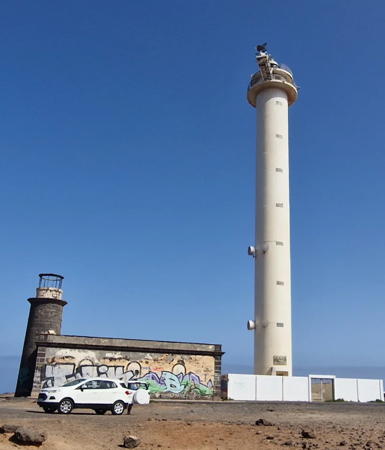
1866. Inactive since 1988. Approx. 10 m (33 ft) round cylindrical stone tower with lantern and gallery, attached to the front of a 1-story stone keeper's house. Tower unpainted; lantern dome is metallic gray. The lighthouse appears in the photo at right, Wikimedia has Marc Ryckaert's closeup photo, Andrés Medina has a photo, and Agustín Ostolaza has a photo. Endangered: the building is sealed and appears to be abandoned; Spanish Wikipedia says it is amenazado de ruina (threatened with ruin). ARLHS CAI-069.
* Pechiguera (2)
1988 (station established 1866). Active; focal plane 55 m (180 ft); three white flashes every 30 s. 50 m (164 ft) round cylindrical concrete tower with lantern and double gallery. Entire lighthouse painted white; lantern dome is metallic gray. Luca Clerici's 2025 photo is at right, José Manuel has a 2008 photo, Guyomard and Carceller have photos, Trabas has a 2007 photo of the station, Lightphotos.net has a photo of the two lighthouses, and Google has a street view and a satellite view of the station. This lighthouse stands on the southwesternmost point of Lanzarote, marking the north side of the Bocaina Channel separating Fuerteventura from Lanzarote. Located about 4 km (2.5 mi) west of Baja Montaña. Site open, tower closed. . ARLHS CAI-047; ES-12129; Admiralty D2782; NGA 24048.
Punta Delgada (Isla de Alegranza)
1865. Active; focal plane 17 m (56 ft); white flash every 3 s. 15 m (49 ft) round stone tower with lantern and gallery, rising through the front of a 1-story masonry keeper's house. The tower is unpainted gray stone; lantern dome is gray metallic; house painted white with unpainted trim. Violeta Sánchez has a photo, Mash Qimanfaya has a photo, a 2020 closeup is available, and Google has a satellite view. In 2014 the Las Palmas port authority and the government of Lanzarote agreed to share funding for a restoration of this historic lighthouse and Qimanfaya's photo seems to show the results of these improvements. The Isla de Alegranza is the northernmost land of the Canary Islands, located about 25 km (15 mi) north of Lanzarote. Most of the island is occupied by the caldera of a dormant volcano. Boat transportation to Alegranza is available from Órzola at the northern end of Lanzarote. Lighthouse located at the northeastern point of the island. Site open, tower closed. Site manager: Parque Natural de Archipiélago Chinijo. . ARLHS CAI-034; ES-12000; Admiralty D2772; NGA 24076.

Old and new Pechiguera Lights, Lanzarote, August 2025
Instagram photo by Luca Clerici

Information available on lost lighthouses:

Notable faux lighthouses:

Adjoining pages: North: Portugal: Madeira | East: Southwestern Morocco | West: Western Canary Islands

Return to the Lighthouse Directory index | Ratings key

Posted January 15, 2006. Checked and revised August 16, 2025. Lighthouses: 25. Site copyright 2025 Russ Rowlett and the University of North Carolina at Chapel Hill.