Lighthouses of Spain: Western Canary Islands

The Kingdom of Spain occupies nearly 85% of the Iberian Peninsula in southeastern Europe with coastlines facing south and southeast on the Mediterranean Sea and northwest on the Atlantic Ocean. Spain also includes the Balearic Islands in the Mediterranean, the Canary Islands in the Atlantic, and the cities of Ceuta and Melilla on the north coast of Morocco.

The Canary Islands (Canarias in Spanish) are a group of seven volcanic islands located west of the southern coast of Morocco. The islands have been known to Europeans since antiquity; they were inhabited by people related to the Berbers of North Africa before being conquered by Spain during the fifteenth century. They have been Spanish territory ever since.

Since 1978 Spain has been divided into 17 regions called autonomous communities (comunidads autónoma) that have been granted varying degrees of autonomy by the central government. The Canary Islands form one of the autonomous regions, divided into two provinces. This page includes the lighthouses of the western province of Santa Cruz de Tenerife, including the islands of La Palma, El Hierro, La Gomera, and Tenerife. Lighthouses of the eastyern the eastern province of Las Palmas de Gran Canaria, including the islands of Gran Canaria, Fuerteventura, and Lanzarote, are described on the Eastern Canary Islands page..

Located almost in the tropics, the islands are very popular tourist destinations. In case you were wondering, the islands are not named for canary birds; the birds (Serinus canaria) are named for the islands.

The word for a lighthouse is faro in Spanish but its use is generally restricted to the larger coastal light stations. Smaller lighthouses are called balizas (beacons). In Spanish isla is an island, cabo is a cape, punta is a promontory or point of land, péñon is a rock, arrecife is a reef, bahía is a bay, ría is an estuary or inlet, estrecho is a strait, río is a river, and puerto is a port or harbor.

The navigational lights in Spain are the responsibility of the national port authority, Puertos del Estado, but generally they are operated and maintained by regional port authorities. In the Canaries, Puertos Canarios is the regional port authority.

ARLHS numbers are from the ARLHS World List of Lights. ES numbers are from the Spanish national list of lights, Libro de Faros. Admiralty numbers are from volume D of the Admiralty List of Lights & Fog Signals. U.S. NGA numbers are from Publication 113.

General Sources
Online List of Lights - Islas Canarias
Photos by various photographers posted by Alexander Trabas. Hartmut Knape contributed several photos for thi area.
Lighthouses in the Canary Islands
Photos by various photographers available from Wikimedia.
World of Lighthouses - Non-continental Spain
Photos by various photographers available from Lightphotos.net.
Phares d'Afrique
This page, part of Le phare à travers le monde, the web site of Alain Guyomard and Robert Carceller, links to fine photos of many lighthouses of the Canaries.
Anexo: Faros de España
List of Spanish lighthouses with links to articles in the Spanish language Wikipedia.
Spanische Leuchttürme auf historischen Postkarten
Historic postcard images posted by Klaus Huelse.
GPSNavigationCharts
Navigation chart information for the western Canary Islands.
Google Maps
Satellite view of the western Canary Islands.
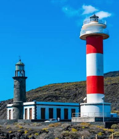

Old and new Fuencaliente Lights, Isla de la Palma, March 2022
Google Maps photo by Jiri VFX


Puerto de la Cruz Lights, Tenerife, March 2025
Google Maps photo by Reinhard Paulitsch

Isla de la Palma Lighthouses
The Isla de la Palma (officially San Miguel de la Palma) is at the western end of the archipelago, about 75 km (45 mi) northwest of Tenerife. Ruggedly mountainous, the island is about 55 km (35 mi) long from north to south; it has a population of about 85,000.

*
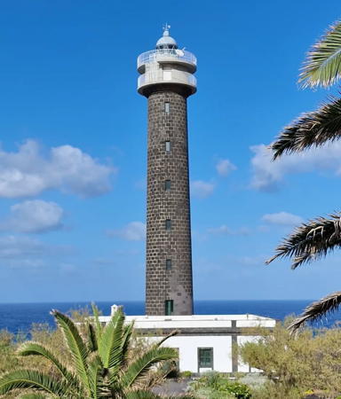
Punta Cumplida
1867. Active; focal plane 63 m (207 ft); white flash every 5 s. 34 m (112 ft) round cylindrical rubblestone tower with lantern and gallery, attached to a 1-story keeper's house. The tower is unpainted dark stone; lantern, gallery, and watch room painted white. The original 2nd order Fresnel lens is on display in the passenger terminal on the Dársena (dock) de Anaga in Santa Cruz de Tenerife. A 2023 photo by Marcos Antonio Sabina Miñón is at right, Luis Vidilla has a 2024 photo, Trabas has a 2007 photo of this lighthouse, a more distant 2006 photo is available, Lightphotos.net has a photo, the municipality of Barlovento has a page for the lighthouse, and Google has a 2025 street view and a satellite view. The lighthouse was restored and its height was increased by 4 m (13 ft) in 1982. In 2017 conversion of the light station for tourist accommodation was approved and in 2019 a luxury boutique hotel opened. Located at the northeastern point of the Isla de la Palma, about 5 km (3 mi) northeast of Barlovento ("Windward"). Site and hotel open, tower closed. Site manager: Faro Punta Cumplida. . ARLHS CAI-029; ES-12990; Admiralty D2846; NGA 23780.
* Santa Cruz Dique Extremo
Date unknown. Active; focal plane 16 m (52 ft); green flash every 5 s. 8 m (26 ft) round barbell-shaped green fiberglass tower. Trabas has Knape's 2023 photo and Google has a satellite view and a distant 2025 street view. Located on the breakwater at Santa Cruz, on the east coast of the island. Accessible by walking the pier. Site open, tower closed. ES-13000; Admiralty D2848.45; NGA 23784.
* Arenas Blancas
1993. Active; focal plane 45.5 m (149 ft); white light occulting three times every 8 s. 38 m (125 ft) fluted round cylindrical white concrete tower with a rounded top; the light is displayed through a horizontal window at the top. 500 mm lens. 1-story keeper's house nearby. Bernd Pützer has a 2025 photo, a 2017 photo and a 2023 photo are available, Trabas has a 2007 photo, and Google has a 2025 street view and a satellite view. This is a very striking modern lighthouse. Located on the Playa de Arenas Blancas, on the southeastern coast of the island, about 8 km (5 mi) southeast of Mazo. Site open, tower closed. ARLHS CAI-002; ES-13025; Admiralty D2849.51; NGA 23798.
*** Fuencaliente (1)
1903. Inactive since 1985. Approx. 12 m (40 ft) round cylindrical stone tower rising from the front of a 1-story stone keeper's house. The lighthouse was mostly rebuilt after suffering major damage in a 1939 earthquake. The original lantern was removed after deactivation. This historic lighthouse was restored around 2003 or 2004 and the present lantern was added at that time. A 2022 photo is at the top of this page, an April 2007 photo shows the restored building well, Tony Hisgett has a 2011 photo, Lightphotos.net has a photo of the two lighthouses, and Google has a 2025 street view. A further restoration in 2022 had the goal of opening the lighthouse to visitors, and the keeper's house is now a visitor center and museum. Located adjacent to the new lighthouse (next entry). Site and museum open, tower status unknown. ARLHS CAI-083.


Punta Cumplida Light, Isla de la Palma, April 2023
Instagram photo by Marcos Antonio Sabina Miñón

* Fuencaliente (2)
1985 (station established 1903). Active; focal plane 36 m (118 ft); three white flashes every 18 s. 24 m (79 ft) round cylindrical concrete tower with lantern and double gallery. Lighthouse painted white with two horizontal red bands. A 2022 photo is at the top of this page, Marianne Perdomo has a photo, Trabas has a 2007 photo, Lutz Hirschmann has an April 2007 closeup, Lightphotos.net has a photo of the two lighthouses, and Google has a 2025 street view and a satellite view of the station. Located at the southern tip of the island, about 13 km (8 mi) south of Los Canarios; accessible by a road with many switchbacks. Site open, tower closed. . ARLHS CAI-037; ES-13030; Admiralty D2850; NGA 23800.
* Punta Lava
1993. Active; focal plane 51 m (167 ft); three white flashes, in a 1+2 pattern, every 20 s. 48 m (157 ft) octagonal white concrete tower with lantern and gallery. Tenan Pérez has the 2025 photo at right, Trabas's closeup also shows the remarkable modern design of this lighthouse, Lightphotos.net has an excellent photo, Michael Apel has a photo, Tamas Miklovicz has a street view from the beach, and Google has a satellite view. Located on the southwestern coast of the island, about 2 km (1.2mi) northwest of Puerto Naos. Site open, tower closed. . ARLHS CAI-042; ES-13032; Admiralty D2851; NGA 23801.
* [Tazacorte Inner Breakwater West Head]
Date unknown. Active; focal plane about 12 m (39 ft); three red flashes, in a 2+1 patern, every 12 s. A scupture of a stylized human figire tends this tiny post red post light. Ted Potters has a photo, Trabas has a photo, and Google has a satellite view. Located on an inner breakwater of Tazacorte, about 5 km (3 mi) north of the Punta Lava lighthouse. probably accessible by walking the pier. Site status unknown. ES-13044; Admiralty D2852.4.
* Tazacorte Breakwater East Corner
Date unknown. Active; focal plane about 22 m (72 ft); two red flashes every 7 s. 6 m (20 ft) round tapered red concrete tower. Trabas has a photo and Google has a satellite view. Located on the main breakwater at Tazacorte. Site status unknown. ES-13041; Admiralty D2851.8.


Punta Lava Light, Isla de la Palma, July 2025
Google Maps photo by Tenan Pérez


Isla del Hierro Lighthouses
Isla del Hierro ("Iron Island") is the smallest of the seven main Canary Islands and is the farthest west and south. Since this was the westernmost point of land known in classical times, Renaissance and early modern mapmakers often measured longitude eastward from the meridian of El Hierro, giving the island its alternate name "Isla del Meridiano." The population of the island is about 12,000.

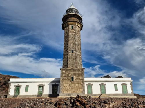
Punta Orchilla
1933. Active; focal plane 132 m (433 ft); white flash every 5 s. 25 m (82 ft) octagonal stone tower with lantern and double gallery, rising from a 2-story square stone base, attached to a 1-story U-shaped keeper's house. 1st order Fresnel lens in use. The tower is unpainted gray stone; lantern dome is gray metallic. This is probably Spain's most remote lighthouse. Sara Benetti's 2023 photo is at right, Trabas has a 2007 photo, Wikimedia has Hans Bezard's 2012 photo, Edson Alejandro Afonso Delgado has a 2019 closeup, Lightphotos.net has a photo, Guyomard and Carceller have a photo by David Moré Aguirre, José Gordillo Nogales has an excellent 2007 photo, Ronan Jameson has a 2016 street view, and Google has a satellite view. Located at the southwestern tip of the island, once the end of the known world for Europeans. Accessible by a 25 km (15 mi) road (at least partly unpaved) from the town of Sabinosa. Site open, tower closed. . ARLHS CAI-066; ES-13060; Admiralty D2836; NGA 23808.
* La Estaca (Puerto de Hierro) Dique Extremo
Date unknown. Active; focal plane 14 m (46 ft); green flash every 5 s. 7 m (23 ft) round barbell-shaped green fiberglass tower. Trabas has a photo and Google has a satellite view and a distant street view. Located on the breakwater at Puerto de la Estaca, near the northeastern tip of the island. Accessible by walking the pier. Site open, tower closed. ES-13070; Admiralty D2838; NGA 23804.

Punta Orchilla Light, Hierro, September 2023
Instagram photo by Sara Benetti

Isla de la Gomera Lighthouses
La Gomera, the third smallest of the seven main islands, is located about 30 km (18 mi) off the southwestern tip of Tenerife. Roughly circular with a diameter of about 20 km (13 mi), the island has a population of about 23,000.

*
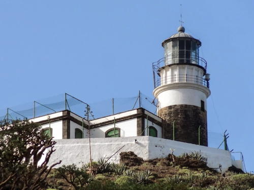
San Cristóbal (1)
1903. Inactive since 1978. 6 m (20 ft) round cylindrical masonry tower attached to the front of a 1-story masonry keeper's house. Building painted white with unpainted stone trim; lantern roof is metallic green. A 2025 photo is at right, a closeup photo is available, and Google has a street view. Located in front of the newer lighthouse (next entry). ARLHS CAI-086.
* San Cristóbal (2)
1978 (station established 1903). Active; focal plane 84 m (276 ft); two white flashes every 10 s. 15 m (49 ft) round cylindrical concrete tower with lantern and double gallery. 3rd order clamshell Fresnel lens in use. Lighthouse painted white with one horizontal red band below the galleries. A 2025 photo is at right, Trabas has a closeup 2007 photo, Dirk Schmitt's closeup photo shows the mountains of Tenerife in the background, and Google has a 2025 street view and a satellite view of the station. This lighthouse is a shorter version of the newer Faro de Fuencaliente on Isla de la Palma. Located atop a precipitous headland just north of San Sebastián de la Gomera, the principal town and port of the Isla de la Gomera, on the east side of the island. Site open, tower closed. ARLHS CAI-054; ES-12950; Admiralty D2842; NGA 23812.
San Sebastián Dique Extremo
Date unknown. Active; focal plane 15 m (49 ft); green flash every 5 s. 7 m (23 ft) round barbell-shaped green fiberglass tower. Trabas has Knape's 2022 photo and Google has a satellite view and a distant street view. Located on the breakwater at Puerto de San Sebastián, on the east side of the island. Site and tower closed (the end of the pier is fenced). ES-12965; Admiralty D2844.7; NGA 23816.

Old and new San Cristóbal Lights, La Gomera, December 2025
Google Maps photo by Lyndsey

Isla de Tenerife South Coast Lighthouses
Tenerife is the largest of the Canary Islands. Its name means "white mountain," a reference to the snows that sometimes fall atop the great volcano El Teide, which rises to a height of 3718 m (12,200 ft) and is visible in clear weather from the coast of Morocco. The island's population is nearing one million.

*
Punta Abona (1)
1902. Inactive since 1976. 6 m (20 ft), lantern mounted directly on the roof at the front of a 1-story masonry keeper's house. Building painted white with unpainted stone trim; lantern roof is metallic green. A photo is at right, a 2024 closeup is available, the lantern is visible in a photo of the station by H.H. Schüller, both lighthouses are seen in an October 2007 photo, and Google has a 2018 street view. The lantern may have been removed recently; it is not seen in 2025 and 2026 photos. Lighthouse Digest has a photo by Xavier Leroy and reports that the building had been given to the town of Arico and was to be renovated as a restaurant school. It's clear that this didn't happen, but the building was restored by 2018. Located beside the newer lighthouse (next entry). ARLHS CAI-081.
* Punta Abona (2)
1976 (station established 1902). Active; focal plane 54 m (177 ft); three white flashes every 20 s. 39 m (128 ft) round cylindrical concrete tower with lantern and double gallery. Lighthouse painted white with three horizontal red bands. Peter Ackerman's 2025 photo is at right, H.H. Schüller has a closeup photo, The tower carries a radar antenna on a platform extended from the lower gallery. Guyomard and Carceller have good photos by Jean-Michel Penin, Trabas has a 2005 photo by Klaus Kern, Szilárd Székely has a 2022 photo, Martin Křivda has a 2018 street view, and Google has a fine satellite view of the station. This lighthouse is a taller version of the newer Faro de Fuencaliente on Isla de la Palma. Located on the southeastern coast of Tenerife, on a point of land about 2.5 km (1.5 mi) southeast of Poris de Abona. Site open, tower closed. . ARLHS CAI-022; ES-12870; Admiralty D2829; NGA 23828.
Punta Rasca (1)
1895. Inactive since 1978. 6 m (20 ft), lantern mounted directly on the roof at the front of a 1-story masonry keeper's house. Building painted white with unpainted stone trim; lantern roof is metallic green. Lightphotos.net has a closeup photo by Gerard Mulders, the light is seen in José Mesa's photo and a 2012 photo of both lighthouses is available. This building is very close to the edge of the cliff; it may be endangered. Located in front of the newer lighthouse (next entry). ARLHS CAI-085.

New and old Abona Lights, Tenerife, February 2025
Google Maps photo by Peter Ackerman
Punta Rasca (2)
1978 (station established 1895). Active; focal plane 51 m (167 ft); three white flashes every 12 s. 32 m (105 ft) round cylindrical concrete tower with lantern and double gallery. Lighthouse painted white with three horizontal red bands. A 2026 photo and a view from the sea are available, José Mesa has a good 2007 photo, Lightphotos.net has a photo by Gerard Mulders, Trabas has a distant 2007 photo, Simon Thunberg has a street view, and Google has a satellite view. This lighthouse is a taller version of the newer Faro de Fuencaliente on Isla de la Palma. Located on the southernmost tip of Tenerife, about 15 km (9 mi) southeast of Los Cristianos. Site and tower closed. . ARLHS CAI-050; ES-12890; Admiralty D2830; NGA 23832.
* Los Cristianos Dique Extremo
Date unknown. Active; focal plane 13 m (43 ft); red flash every 5 s. 7 m (23 ft) round barbell-shaped red fiberglass tower. Trabas has Knape's closeup 2022 photo, Lightphotos.net has a photo, Vadim Galitsyn has a street view along the pier, and Google has an indistinct satellite view. Los Cristianos is a terminal for ferries to La Palma, El Hierro, and La Gomera. Located on the breakwater at Puerto de los Cristianos, near the southwestern tip of the island. Accessible by walking the pier. Site open, tower closed. ES-12900; Admiralty D2831; NGA 23836.

Isla de Tenerife North Coast Lighthouses

* Punta de Teno (1)
1897. Inactive since 1976. 8 m (26 ft) round cylindrical stone tower with lantern and gallery, attached to the front of a 1-story masonry keeper's house. Tower unpainted; keeper's house painted white with unpainted stone trim; lantern painted white. A 2010 photo is available, Google has a 2017 street view, the old tower can be seen in a distant view of the site, and a 2013 photo of the lantern showed it to be in poor condition. Things got worse:in a 2022 photo: the lantern is missing its dome. In 2025 a €1.6 million project, funded by an EU grant, will restore the lighthouse and convert it to a café and visitor center. Located in front of the newer lighthouse (next entry). ARLHS CAI-084.
* Punta de Teno (2)
1976 (station established 1897). Active; focal plane 60 m (197 ft); three white flashes, in a 1+2 pattern, every 20 s. 20 m (66 ft) round cylindrical concrete tower with lantern and double gallery. Lighthouse painted white with two horizontal red bands. Bojana Koroman has a 2023 photo, Trabas has a 2007 photo, Grethe Anæus has a photo, Sergey Ananin has a street view, Wikimedia has a distant view, the Degree Confluence Project has a distant view from the sea that shows the magnificent setting of this site, and Google has a 2017 street view and a satellite view. This lighthouse is another version of the newer Faro de Fuencaliente on Isla de la Palma. Located on the westernmost tip of Tenerife, about 11 km (7 mi) west southwest of Buenavista del Norte. Site open, tower closed. . ARLHS CAI-033; ES-12920; Admiralty D2832; NGA 23840.

Buenavista Light, Tenerife, December 2023
Google Maps photo by Bob Bradley
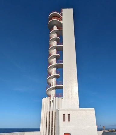
* Punta Buenavista (Buenavista del Norte)
1997. Active; focal plane 76.5 m (251 ft); four white flashes every 11 s. 40.5 m (133 ft) square cylindrical concrete tower with an external spiral staircase that winds around a column in front of the main tower. Bob Bradley's 2023 photo is above right, Libor Wunsch has a 2024 photo, another good photo of this remarkable design is available, Trabas has a 2007 photo, and Google has a 2024 street view and a satellite view. Located on a promontory about 4 km (2.5 mi) northeast of Buenavista del Norte. Site open, tower closed. . ARLHS CAI-004; ES-12925; Admiralty D2831.8; NGA 23838.
* Puerto de la Cruz
1995. Active; focal plane 31 m (102 ft); two white flashes every 7 s. 27 m (89 ft) square cylindrical skeletal tower with an external stairway winding around a central column, all mounted on a 1-story equipment building; there appears to be an enclosed watch room and the light is displayed from a platform atop the tower. The lighthouse is dark brown steel with white trim. Another remarkable modern design. A 2025 photo by Reinhard Paulitsch is at the top of this page, José Antonio has a 2021 photo, Trabas has a 2007 closeup, Wikimedia has Silvio Dellacqua's photo, Lightphotos.net has an excellent photo, another good photo is available, and Google has a street view and a satellite view. Located at a point of land on the waterfront of Puerto de la Cruz, the principal city on the north coast of Tenerife. Site open, tower closed. . ARLHS CAI-020; ES-12934; Admiralty D2833; NGA 23842.
* Bajamar
Date unknown. Active (unofficial); focal plane about 17 m (56 ft); continuous white light. Approx. 12 m (39 ft) octagonal stone tower. Éva Ágnes Molnár has a 2024 photo, a 2022 photo and a 2019 photo are available, José Manadé has a photo of the light in action, and Google has a street view and a satellite view. Located on the waterfront of Bajamar. Site open, tower closed. Not listed by the Admiralty. .
* Punta del Hidalgo
1991. Active; focal plane 52 m (171 ft); three white flashes every 16 s. 50 m (164 ft) white masonry tower, vertical at the front but stepped irregularly in the rear, giving the tower a pyramidal form; the light is displayed from a short post at the peak of the tower. An artistic, very striking design for a lighthouse. A 2023 photo by Remco Arends is at right, Norma Guzman has a 2021 photo, has a 2026 closeup photo, a 2024 closeup and another closeup are available, Wikimedia has Klaus Peter's 2013 photo, Trabas has a 2007 photo, and Google has a street view and a satellite view. Located on the waterfront in Punta del Hidalgo, a town near the east end of the northern coast of Tenerife. Site open, tower closed. . ARLHS CAI-035; ES-12945; Admiralty D2818; NGA 23854.

Punta del Hidalgo Light, Tenerife, June 2023
Google Maps photo by Remco Arends

Isla de Tenerife East Coast Lighthouses
Punta de Anaga
1863. Active; focal plane 247 m (810 ft); six white flashes, in a 2+4 pattern, every 30 s. 21 m (69 ft) round cylindrical stone tower with lantern and gallery, attached to the front of a 1-story keeper's house. Original 1st order Barbier & Fenestre Fresnel lens in use. Tower is unpainted stone; lantern, gallery and keeper's house painted white, with green trim on the house. Gianluca Rizzetto's 2022 photo is at right, a closeup photo and a second closeup are available, a good 2019 photo is available, Trabas has a 2004 photo by Arno Siering, Anatoly Vladimirov has a street view, and Google has a satellite view. This historic lighthouse, the oldest active lighthouse in the islands, is the traditional landfall light for Tenerife. Located at the northeastern tip of the island; accessible only by a lengthy hike. Site and tower closed. . ARLHS CAI-001; ES-12630; Admiralty D2820; NGA 23852.
* Santa Cruz de Tenerife Muelle Sur ("Farola del Mar")
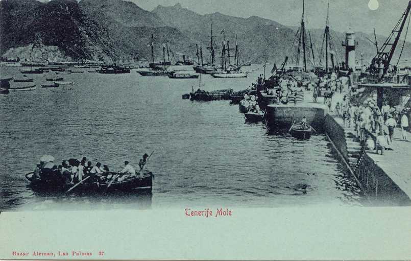
1863. Inactive since 1954 (a decorative light is probably displayed). 6 m (20 ft) hexagonal wood tower (covered by vinyl siding?) with lantern and gallery. Tower painted white, lantern and gallery gray. Joan Ammetller has a 2020 photo, C.W. Bash has a photo, a fine closeup is available, Huelse has a historic postcard view, and Google has a street view and a satellite view. The little lighthouse has been nicely restored; a 5th order (?) Fresnel lens is mounted in the lantern. Located on the waterfront of Santa Cruz de Tenerife, the provincial capital, near the ferry terminals. Site open, tower closed. ARLHS CAI-076.
Santa Cruz de Tenerife Darsena del Este
Date unknown. Active; focal plane 13 m (43 ft); two green flashes every 7 s. 6 m (20 ft) round tower with a flared top, painted green with a white base. Trabas has Knape's 2023 photo and Google has a satellite view. Located at the south end of the east breakwater mole of Santa Cruz de Tenerife. Site and tower closed. Site and tower closed. ES-12680; Admiralty D2822.8; NGA 23859.
Santa Cruz de Tenerife Dique del Sur
Date unknown. Active; focal plane 19 m (62 ft); two red flashes every 7 s. 5 m (17 ft) round tower with a flared top, painted red. Trabas has Knape's 2023 photo and Google has a satellite view. Located at the north end of the main breakwater mole of Santa Cruz de Tenerife. Site and tower closed but the light can be seen distantly from the waterfront. Site and tower closed. ES-12690; Admiralty D2822; NGA 23868.

Punta de Anaga Light, Tenerife, November 2022
Google Maps photo by Gianluca Rizzetto
Santa Cruz de Tenerife Dique de Los Llanos
Date unknown. Active; focal plane 13 m (43 ft); three green flashes every 9 s. 6 m (20 ft) round tower with a flared top, painted green. Trabas has Erich Hartmann's closeup 2019 photo and Google has a satellite view and an indistinct street view. Located at the south end of the main breakwater mole of Santa Cruz de Tenerife. Site and tower closed but the light can be seen from the waterfront nearby. Site status unknown. ES-12715; Admiralty D2826.72; NGA 23912.

Information available on lost lighthouses:

Notable faux lighthouses:

Adjoining pages: North: Portugal: Madeira | East: Eastern Canary Islands

Return to the Lighthouse Directory index | Ratings key

Posted January 15, 2006. Checked and revised October 12, 2026. Lighthouses: 28. Site copyright 2026 Russ Rowlett and the University of North Carolina at Chapel Hill.