Lighthouses of the United States: Indiana

The United States of America is a federal union of 50 states and a capital district. The midwestern state of Indiana has a short coastline, about 45 miles (70 km) long, on the southern end of Lake Michigan. On this coast there is only one historic light station, near the east end at Michigan City. This station is sometimes described as "Indiana's only lighthouse." Actually the state also has a number of active and interesting pierhead lights in the industrialized areas southeast of Chicago. Unfortunately there is no lighthouse preservation group watching out for these lights. Perhaps because of this the pierhead light at Calumet Harbor was demolished in 1995.

Aids to navigation in Indiana are maintained by the U.S. Coast Guard Sector Lake Michigan and its Aids to Navigation Team based at Muskegan, Michigan but ownership (and sometimes operation) of historic lighthouses has been transferred to local authorities and preservation organizations in many cases.

ARLHS numbers are from the ARLHS World List of Lights. USCG numbers are from Volume VII of the U.S. Coast Guard Light List.

General Sources
Indiana Lighthouses
Excellent photos and historical accounts by Kraig Anderson.
Seeing the Light - Indiana Lighthouses
Outstanding historical accounts and photos posted by Terry Pepper.
Lighthouse Hunters - Indiana
Photos and accounts by Christine and Tom Cardaci.
Lighthouses in Indiana
Photos by various photographers available from Wikimedia.
Leuchttürme USA auf historischen Postkarten
Historic postcard images posted by Klaus Huelse.
U.S. Coast Guard Navigation Center: Light Lists
The USCG Light List can be downloaded in pdf format.
GPSNautical Charts
Navigation chart for Indiana.


East Pierhead Light, Michigan City, July 2018
Instagram photo
by Kisha Johnson

Lake County (East Chicago and Gary) Lighthouses
Calumet Harbor is in Illinois but its breakwaters extend across the state line into Indiana waters. Gary is an industrial city near the Illinois border about 25 mi (40 km) southeast of downtown Chicago. As many of its factories have closed Gary has lost more than half its 1960 population; currently the population is estimated at about 65,000.
[Calumet Harbor (2)]
1995 (station established 1905). Active; focal plane 51 ft (16 m); red flash every 2.5 s. Approx. 46 ft (14 m) round cylindrical "D9" tower, painted white with one red horizontal band. Bing has a satellite view. Anderson has a photo of the 1905 lighthouse as it appeared in 1914 and another photo showing how the lighthouse was raised atop a new lower story in 1923. Anderson also has a 1983 photo. Badly deteriorated due to lack of maintenance, the lighthouse was demolished in 1995. Located at the end of the attached breakwater at the harbor entrance. Site and tower closed. Owner/site manager: U.S. Coast Guard. ARLHS USA-102; USCG 7-19830.
Calumet Harbor Entrance South Side
1995 (?). Active; focal plane 30 ft (9 m) (?); green flash every 4 s. 30 ft (9 m) round cylindrical "D9" tower, mounted on a square platform supported by four cylindrical legs and painted white with one green horizontal band. Bing has a satellite view. It's likely that the focal plane has been raised from the listed 30 ft and is closer to the 50 ft (15 m) level of the companion harbor light. Located at the north end of the detached section of the Calumet Harbor Breakwater, across the entrance from the Calumet Harbor Light. Accessible only by boat. Site and tower closed. Owner/site manager: U.S. Coast Guard. USCG 7-19835.
Calumet Harbor Breakwater South End
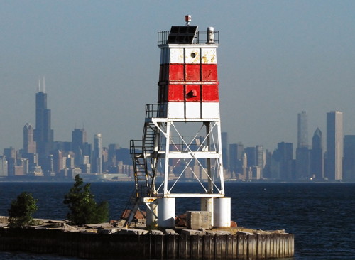
1907 (relocated here in 1937). Active; focal plane 50 ft (15 m); flash every 5 s, alternately red and white. 45 ft (13.5 m) square steel skeletal tower, upper half enclosed, painted white with a red horizontal band. Lantern removed; the solar powered light is displayed from the top. Fog horn (2 s blast every 15 s). Gary Martin's photo is at right, a 2009 photo is available, and Bing has an indistinct satellite view. This poorly-known lighthouse is historic. Originally the north pierhead lighthouse at Holland, Michigan, it was replaced there in 1936 by a light tower on the fog signal building (creating the lighthouse now known as "Big Red" in Holland). Anderson has a historic photo of this tower at Holland in 1913. Located at the east end of a detached breakwater at the harbor entrance. Accessible only by boat. Site and tower closed. Owner/site manager: U.S. Coast Guard. ARLHS USA-1190; USCG 7-19800.
Calumet Breakwater Light
Breakwater South End Light and Chicago Skyline, Calumet City, June 2010
Flickr photo copyright Gary Martin; used by permission
[Indiana Harbor (2)]
1985 (station established 1923). Active; focal plane 48 ft (15 m); continuous green light. The modern light is a round cylindrical "D9" tower, painted white with one green horizontal band. The Coast Guard has a historic photo of the original lighthouse, which had a square light tower with lantern and gallery centered on a 2-story keeper's house, all standing on a large rectangular concrete pier. This lighthouse became redundant as the harbor area was expanded, surrounding its location. The present light, marked as Indiana Harbor Light 5, stands on the original pier at the south end of the east breakwater; Google has a satellite view. Site and tower closed. Owner/site manager: U.S. Coast Guard. ARLHS USA-402; USCG 7-19690.
Indiana Harbor East Breakwater
1935. Active; focal plane 78 ft (24 m); green light, 3 s on, 3 s off. 75 ft (23 m) square cylindrical steel tower mounted on a raised steel platform. Lantern removed; the light is displayed from a short mast. Structure painted white with red roofs. Fog horn (2 blasts every 20 s) on demand. Pepper has a fine page for the lighthouse including the photo at right, the Cardacis have a page with several photos, the Carter family has photos taken in 2010, Darrell Williams has a 2021 aerial view, the Coast Guard has a historic photo, and Google has a satellite view. This lighthouse, a copy of the much-better-known pierhead lighthouses at Port Washington, Wisconsin, and Huron, Ohio, deserves some attention and probably needs restoration. Located at the end of the breakwater on the east side of the harbor entrance in East Chicago. Accessible only by boat. Site and tower closed. Owner/site manager: U.S. Coast Guard. ARLHS USA-401; USCG 7-19675.
Buffington Harbor Breakwater
1926. Active (privately maintained); focal plane 48 ft (14.5 m); red flash every 4 s. 46 ft (14 m) round concrete tower mounted on an oval-shaped fog signal structure. Entire lighthouse painted red, the color having weathered to red orange. Pepper has a fine page for the lighthouse, a 2010 photo is available, the Cardacis have a page with several photos, C.W. Bash haas a 2006 photo, and Google has a satellite view and very distant street view. The lighthouse was built by the Universal Portland Cement Company for a harbor serving a giant cement plant. Part of the cement plant property was sold in 1995 for casino development. (Donald Trump owned one of the two floating casinos that were placed on the waterfront, but he sold his interest in 2007. The casino moved onshore, but it closed in April 2021.) Located at the end of the breakwater on the east side of Buffington Harbor in Gary. Accessible only by boat; there's a distant view from Industrial Drive. Site and tower closed. Owner: City of Gary. Site manager: Gary New Century LLC. ARLHS USA-1017; USCG 7-19630.

Indiana Harbor East Breakwater Light, Gary, 2010
photo copyright Terry Pepper; used by permission
Gary West Breakwater
1911. Active (privately maintained); focal plane 40 ft (12 m); red flash every 10 s, every fourth flash omitted. 40 ft (12 m) round steel tower, painted red. Fog horn (blast every 30 s). The original 6th order Fresnel lens is mounted in the tower but not in use; the active light is an acrylic lens on top of the lantern. Fog horn (blast every 30 s). Pepper has a good page for the lighthouse including the photo at right, USLHS has a closeup by Chad Kaiser, the Cardacis have a page with several 2010 photos, C.W. Bash has a distant view, and Google has a satellite view. Built by the Indiana Steel Company, this lighthouse has an unusual tapered-conical design seen well in the Coast Guard's 1915 photo. In 2017 U.S. Steel used a crane to bring the lighthouse ashore for repairs and repainting before reinstalling it on the pier. Located at the end of the long west breakwater at Gary. Accessible only by boat. Site and tower closed. Owner/site manager: U.S. Steel Corporation (Gary Works). ARLHS USA-317; USCG 7-19610.

LaPorte County (Michigan City) Lighthouses
Michigan City is a town of about 32,000 residents near the border with Michigan.

[Michigan City West Pierhead (3)]
Date unknown (station established 1875). Active; focal plane 41 ft (12.5 m); red flash every 6 s. Approx. 36 ft (11 m) post. Robert Urgo has a street view from the neighboring breakwater and Google has a satellite view. The first lighthouse on the west pier was the 1871 east pier light, relocated in 1875. Swept away by a storm in 1886, it was not replaced until 1904. Huelse has a postcard view of the 1904 tower, a round cast iron tower with lantern and gallery. This lighthouse was still in place as of 1926. We don't know when the lighthouse was removed. Located at the end of the short east pier at Michigan City. Site status unknown. USCG 7-19565.
Michigan City Breakwater
1911. Active; focal plane 36 ft (12 m); red flash every 4 s. 32 ft (9.5 m) square pyramidal tower with the light mounted at the top. Lighthouse painted white with a narrow red horizontal band near the top. Mike Norris has a 2020 photo, light is at lower left in Tom Gill's photo of the East Pierhead lighthouse and Google has a satellite view. The National Archives has a 1914 photo. This light is similar to the Muskegon South Breakwater Light in Michigan. Located at the north end of a detached breakwater just offshore from the East Pierhead light. Site and tower closed. Owner/site manager: U.S. Coast Guard. ARLHS USA-1016; USCG 7-19555.

Gary West Breakwater Light, Gary, June 2010
photo copyright Terry Pepper; used by permission

* Michigan City East Pierhead (2)
1904 (station established 1871). Active; focal plane 55 ft (17 m); white light occulting every 4 s. 49 ft (15 m) octagonal cylindrical steel tower mounted on a square brick and steel fog signal building; rotating 2130C lens. Lighthouse painted white, lantern black; fog signal building roof is red. Fog horn (2 blasts every 30 s). The original elevated walkway along the pier connects the lighthouse to shore. Kisha Johnson's 2018 photo is at the top of this page, Kevin McNally has a 2022 photo, Paul Everett has a 2008 photo, Tom Gill has a 2007 photo, Huelse has a distant postcard view, Michael Kucharski has a street view along the pier, and Google has a satellite view. The original lighthouse, a wood tower, was moved to the west pierhead in 1875 and swept away by a storm in 1886. In 2007 the present lighthouse became available for transfer under NHLPA. The City of Michigan City applied for ownership and its application was approved. In 2014 the lighthouse was repainted and refurbished in a $160,000 project funded by the Michigan City Port Authority and the Michigan City Redevelopment Commission. Located at the end of the pier off the east side of the harbor. Accessible by walking the pier. Views from Washington Park. Site open, tower closed. Owner/site manager: City of Michigan City. . ARLHS USA-493; USCG 7-19545.
**** Michigan City (2)
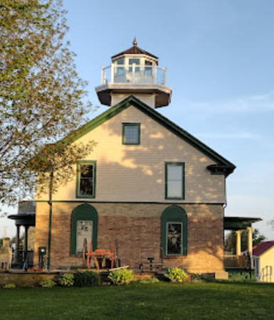
1858 (station established 1835). Inactive since 1904. 34 ft (10 m) square cylindrical wood tower mounted on 2-story brick and wood keeper's house. Tower painted white with a black lantern roof; frame upper story of keeper's quarters painted dark green; roof is red.William Ball's 2023 photo is at right, Jimmy Emerson has a 2014 photo, a 2012 photo and a 2018 photo are available, and Google has a street view and a good satellite view. Lighthouse Digest also has Jim Merkel's feature article on the light station. This historic lighthouse has a typical "early classic schoolhouse" design, similar to the lighthouses at Grand Traverse, Michigan, and Pottawatomie, Wisconsin. The building continued in service until 1940 as the keeper's quarters for the Michigan City East Pierhead Light. Brick oil house and other outbuildings also preserved. The lighthouse is now the Michigan City Old Lighthouse Museum; the original 5th order L. Sautter Fresnel lens is on display. In 2003 members of the Hoosier Lighthousing Club rebuilt the spiral stairway, allowing visitors to climb to the lantern room for the first time. The light tower and lantern (a replica installed in 1973) developed serious leaks due to storm damage and were replaced in 2014 with a historically accurate replica. More extensive repairs and restoration were completed in the fall of 2017. Located at Franklin Street and Lakeshore Drive in downtown Michigan City. Site open, museum and tower open every afternoon except Monday. Owner: City of Michigan City. Site manager: Michigan City Historical Society . ARLHS USA-913.

1858 Michigan City Light, Michigan City, May 2023
Google Maps photo by William Ball

Inland Lighthouses
* Cedar Lake (Lighthouse Restaurant)
2009. Active; focal plane about 38 ft (12 m); continuous (?) white light. Copper lantern mounted atop a 2-story waterfront restaurant building. A 2016 photo is available and Google has a satellite view. Cedar Lake is a 2 mi (3 km) long natural lake in Lake County. Located at East Lakeshore Drive and Constitution Avenue in the town of Cedar Lake. Site open, tower closed. Owner/site manager: Lighthouse Restaurant.
* Lake Shafer
1929(?). Active; focal plane 25 ft (7.5 m); flashing amber light. 25 ft (7.5 m) round cylindrical rubblestone tower, unpainted, with a small lantern and gallery. Google has a satellite view. Lake Shafer is a reservoir about 10 mi (16 km) long, formed by damming the Tippecanoe River near Monticello in White County. The lighthouse is on the grounds of a lakeside bed and breakfast inn. Located on the east side of the lake, across from the mouth of Big Monon Creek. Site open to guests of the inn; tower closed. Owner/site manager: Lighthouse Lodge Bed and Breakfast.
* Culver (Lake Maxinkuckee) (3)
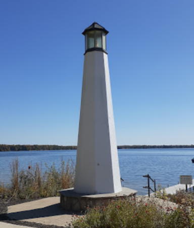
2006(?). Active; focal plane 50 ft (15 m); flashing green light. 37 ft (11 m) octagonal fiberglass tower with lantern. The tower is unpainted white concrete; lantern painted dark gray. Victoria Hole's 2020 photo is at right, the town has a photo, Wikimedia has a distant view, and Google has a street view and a satellite view. A first version of this lighthouse, installed in 2005, was promptly destroyed by vandals. Lighthouse Digest has a photo of a privately-built lighthouse that stood in this area in the early 1900s. Located in a park on the waterfront of Culver, a town at the northwestern corner of Lake Maxinkuckee, a large natural lake in Marshall County. Owner/site manager: Town of Culver.
* [Cooper Memorial]
1997. Active; focal plane about 8 m (26 ft); flashing (?) white light. Approx. 5 m (17 ft) round stone tower with lantern, painted white; lantern painted black. The Cardacis have a page for this lighthouse and Bing has a distant satellite view. The lighthouse was built in memory of Charles W. Cooper, a local outdoorsman. Located on the east side of the Prairie Creek Reservoir near Muncie. Site open, tower closed. Owner/site manager: Muncie Sailing Club.

Information available on lost lights:

  • Calumet Pierhead (1873-1976). Anderson links to a mural that has a view of the original lighthouse in the lower right corner. The 1898 lighthouse was removed after being struck by a ship in 1976.

Culver Light, Culver, October 2020
Google Maps photo by Victoria Hole

Notable faux lighthouses:

Adjoining pages: North: Michigan Western Lower Peninsula | South: Kentucky | West: Illinois

Return to the Lighthouse Directory index

Posted January 2004. Checked and revised December 23, 2024. Lighthouses: 11. Site copyright 2024 Russ Rowlett and the University of North Carolina at Chapel Hill.