Lighthouses of the United States: Michigan's Western Lower Peninsula

The United States of America is a federal union of 50 states and a capital district. The state of Michigan comes in two parts: the Lower Peninsula (between Lakes Huron and Michigan) and the Upper Peninsula (between Lakes Michigan and Superior). Putting the two together, the state has an astonishingly long coastline, so it is not surprising that Michigan has more lighthouses than any other U.S. state, by quite a large margin. The Directory has information on more than 130 sites. 

This lighthouse heritage is well recognized. Michigan is the only state that supports lighthouse preservation with a program of annual grants from the state to local preservation groups. All over the state, volunteers are working hard to save and restore lighthouses. There is a state preservation society, the Michigan Lighthouse Conservancy, and the Great Lakes Lighthouse Keepers Association is also based in the state.

Michigan was organized as a territory in 1805 and admitted to the union as the 26th state in 1837.

This page includes lighthouses of the west coast of the Lower Peninsula, which faces Lake Michigan.

Aids to navigation in Michigan are maintained by the U.S. Coast Guard Ninth District, but ownership (and sometimes operation) of historic lighthouses has been transferred to local authorities and preservation organizations in many cases. Lights from the Indiana border through the Fox Islands are the responsibility of the Aids to Navigation (ATN) team at Muskegon, while those in the northern end of the lake are the responsibility of the ATN team at Sault Sainte Marie in the Upper Peninsula.

ARLHS numbers are from the ARLHS World List of Lights. USCG numbers are from Volume VII of the United States Coast Guard Light List.

General Sources
Seeing the Lights: The Lighthouses of Michigan
A wonderful site by the late Terry Pepper, with fine photos, accounts of recent visits to many of the lighthouses, and extensive historical information.
Michigan Lighthouses
Excellent photos and information posted by Kraig Anderson.
Lake Michigan Lighthouses
Photos by C.W. Bash.
Lighthouse Hunters - Lower Michigan
Photos and accounts by Christine & Tom Cardaci.
Lighthouses of the Great Lakes
Photos by various photographers available from Wikimedia.
Michigan, United States Lighthouses
Aerial photos posted by Marinas.com.
Leuchttürme USA auf historischen Postkarten
Historic postcard images posted by Klaus Huelse.
GGreat Lakes Lighthouse Keepers Association
GLLKA encourages lighthouse preservation throughout the Great Lakes states, but it is best known for its work preserving the Round Island, St. Helena Island, and Cheboygan Range Lights in the Straits of Mackinac area.
Sable Points Lighthouse Keepers Association
The association manages the Big Sable Point, Little Sable Point, Ludington North Breakwater, and White River Lighthouses.
Michigan Lighthouse Conservancy
This organization is dedicated to the preservation of lighthouses and life saving stations throughout the state.
Michigan Lighthouse Assistance Program
This state program provides grants annually for lighthouse preservation.
U.S. Coast Guard Navigation Center: Light Lists
The USCG Light List can be downloaded in pdf format.
NOAA Nautical Charts
Official nautical charts for the coast can be viewed online.
Navionics Charts
Navigation chart for Lake Michigan.


White River Light, White Hall, October 2016
Flickr Creative Commons photo by Tom Gill


South Pierhead Lights, Grand Haven, November 2015
Flickr Creative Commons photo by Jan Davis Ruthig

Berrien County Lighthouses
** St. Joseph (Benton Harbor) North Pierhead Inner
1907. Active; focal plane 53 ft (16 m); continuous white light. 53 ft (16 m) octagonal steel tower mounted on square 1-story cast iron fog signal building, built midway in the pier. Lighthouse painted white, lantern and gallery black; fog signal building roof is red. Tom Gill's photo is at right, Gill has another photo, Pepper has a page for the lighthouses, Teresa Forrest has a good photo of both St. Joseph lights, Wikimedia has Russell Sekeet's photo, Jonathan Chapman has a street view along the pier, and Google has a satellite view. The Coast Guard has a historic photo. The pier lights replaced a pair of smaller range lights established in 1889. In 2008 the St. Joseph lighthouses became available for transfer under NHLPA and the City of St. Joseph applied for ownership. An engineering survey in the summer of 2008 found that the lights needed at least $1 million in restoration before they could be opened to the public. In late 2012 the 4th order Fresnel lens was removed for restoration and display at the St. Joseph Heritage Museum. The city took ownership of both lighthouses in a ceremony on 8 October 2013. It was estimated that restoration would now require about $2 million. The Lighthouse Forever Fund was launched to receive contributions. A contract for an engineering study was awarded in November. In May 2015 Mihm Enterprises bid $1.7 million for the restoration of the lighthouses and the catwalk. City Commission awarded a $988,000 contract to restore the lighthouses only, deferring the catwalk until more funds could be raised. By May 2016 the restoration was complete. Public tours offered through the Heritage Musuem began on June 11. In 2019 the city considered buying from the Coast Guard the 1907 duplex keeper's quarters, located at 107 North Pier Street near the Coast Guard station. They decided against it, but a private individual purchased the house and is offering to donate it to the city, if the city will agree to move it. Google has a street view and a satellite view of the house. Located on the north side of the St. Joseph River entrance adjacent to Tiscornia City Park in St. Joseph. Accessible by walking the pier. Parking is available in Tiscornia Park at the base of the pier. Site open, tower open to tours (fee) on Thursdays, Fridays, and Saturdays late May through mid September. Owner/site manager: City of St. Joseph. . ARLHS USA-797; USCG 7-19520.
** St. Joseph (Benton Harbor) North Pierhead Outer
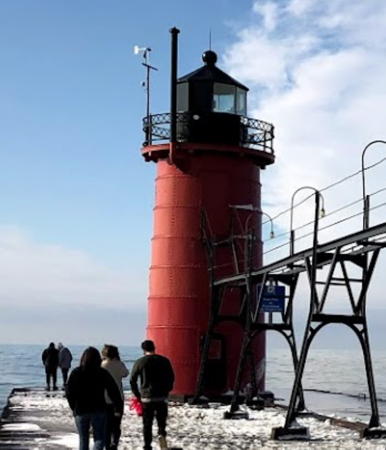
1906. Active; focal plane 31 ft (9.5 m); white light, 3 s on, 3 s off. 30 ft (9 m) round cast iron tower built at the end of the pier. The original 5th order Fresnel lens is on display at the St. Joseph Heritage Museum in St. Joseph. Lighthouse painted white, lantern and gallery black. Fog horn (blast every 30 s) as needed. The original catwalk links this tower to the inner tower and to shore. Sibling of the South Haven tower (see below). Tom Gill's photo is at right, Pepper has a page for the lighthouses, Teresa Forrest has a good photo of both St. Joseph lights, Wikimedia has Russell Sekeet's photo, Patrick James has a closeup, Jonathan Chapman has a street view along the pier, and Google has a drone view and a satellite view. Located at the end of the pier. Accessible by walking the pier. Site open, tower open to tours (fee) on selected Fridays and Saturdays during the summer. Owner/site manager: City of St. Joseph. ARLHS USA-798; USCG 7-19515.

Pierhead Lights, St. Joseph, November 2014
Flickr Creative Commons photo by Tom Gill

Van Buren County Lighthouses
* South Haven South Pierhead (2)
1903 (relocated 1913 when the pier was extended). Station established 1872. Active; focal plane 37 ft (11 m); continuous red light. 35 ft (10.5 m) round cast iron tower with lantern and gallery. Tower painted red, lantern black. Fog horn (2 blasts every 30 s) as needed. Joyce Wagner's photo is at right, Pepper has a fine page for the lighthouse, Anderson's page has winter photos, Kristen Martinez has a 2021 photo, Preston Ferguson has a 2022 closeup, Lighthouse Digest has published a history of the light station, the Coast Guard has a 1914 photo, Huelse has a historic postcard view, Mauricio Vidal Astudillo has a closeup street view, and Google has a satellite view. This lighthouse, a shorter version of the Muskegon South Pierhead Light, replaced an 1872 wood tower. In 1913 the pier was extended and the lighthouse was relocated 425 ft (130 m) to its new ending. The cast iron catwalk linking the tower to shore was relocated from Calumet, Illinois, in 1925. The lighthouse was the front light of a range from 1916 until the 1960s; the rear light, on a 50 ft (15 m) skeletal tower, was removed in the 1960s. The 2-1/2 story wood, hipped-roof keeper's house (1872), located at 91 Michigan Avenue onshore, was transferred to the city for preservation in 2000. The Michigan Maritime Museum has renovated the keeper's house as the Marialyce Canonie Great Lakes Research Library; Google has a street view and a satellite view of the building. When the lighthouse became available under NHLPA in 2010 South Haven City Council approved an application by the Historical Association of South Haven, and in October 2011 that group was selected for ownership. Ownership was transferred officially in a rededication ceremony on 9 August 2012. In late 2014 the maritime museum applied for a grant to repairs to the keeper's house. In 2015 the Association completed a fund drive to raise the $300,000 needed for restoration. Interior restoration began in October 2015 and was completed in the spring of 2016; exterior restoration and repainting were carried out in the fall of 2016. The project was assisted by a $60,000 state grant. The restored lighthouse was rededicated in a ceremony on 19 July 2017. In 2021 portholes were replaced, allowing daylight to return to the interior of the tower. The tower was repainted in 2023. Located at the end of the pier at the foot of Water Street in South Haven. Accessible by walking the pier; parking is available in South Beach Park at the foot of the pier. Site open, tower closed except for an open house during the city's mid-June Harborfest. Owner/site manager: Historical Association of South Haven (South Haven Lighthouse ). ARLHS USA-772; USCG 7-19505.
* Old Harbor Village
2016 (?). Active (?) (unofficial); red light, characteristic unknown. Approx. 30 ft (9 m) hexagonal wood tower with lantern and gallery, painted white; lantern painted red. Google has a street view and a satellite view. The building was for sale for $85,000 in the spring of 2018. Located at 515 Williams Street, next to the South Haven Yacht Club on the south side of the Black River. Site open, tower closed.

South Haven South Pierhead Light, South Haven, September 2011
Flickr Creative Commons photo by Joyce Wagner

Allegan County Lighthouses
* Kalamazoo River (Saugatuck) (replica)
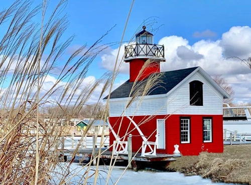
2002 replica of 1859 lighthouse. Active (an unofficial red light is displayed). 9 m (30 ft) square cylindrical wood tower with lantern and gallery, rising from one end of a 1-1/2 story wood keeper's house. Entire building painted with red and white horizontal bands. A 2020 photo is at right, Brandon Dawson has a closeup 2020 photo showing the red light, Andrew Nicolle has a 2007 photo, Teresa Forrest has a fine closeup, and Google has a street view and a satellite view. The original lighthouse was located at the mouth of the Kalamazoo River; Lighthouse Digest has an article on the history of the light station. The replica is located at Union and Hamilton Streets in Douglas, on the south side of the river. (For a decade it was adjacent to the historic passenger steamship Keewatin, as seen in another of Forrests's photos, but the Keewatin was sold in 2012 and relocated to its original home port of Port MacNicoll, Ontario.) Site open, tower closed. Owner/site manager: Sailing Saugatuck. .
* [Saugatuck (Kalamazoo River) Pierhead Lights (3)]
Around 2011; pierhead lights established 1909 (south pier) and 1914 (north pier). Active; north pierhead light focal plane 30 ft (9 m), green flash every 4 s; south pierhead light focal plane 30 ft (9 m), green flash every 4 s. Two 26 ft (8 m) cylindrical "D9" towers; both towers painted white, north pier tower with a single green band and south pier tower with a single red band. Fog horn (blast every 15 s as needed) on the south light. Jeff Rozema has a photo of the south tower and a closeup of the north tower, an aerial photo is available, and Google has a satellite view of the two piers. The current lights replaced steel post lights seen in Pepper's 2002 photo. Located on the breakwaters protecting the river entrance northwest of Saugatuck. Reportedly accessible from a public parking area at the end of Riverside Drive. Site open, towers closed. Owner/site manager: U.S. Coast Guard. ARLHS USA-1266 (south) and 413 (north); USCG 7-19445 (south) and 19450 (north).
 

Kalamazoo Light, Kalamazoo, June 2020
Instagram photo by amazingshots_lighthouse

Ottawa County Lighthouses
* Holland Harbor South Pierhead (3) ("Big Red")
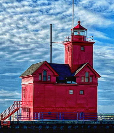
1936 (light tower added to the 1907 fog signal building; station established 1872). Active: focal plane 52 ft (16 m); flash every 10 s, alternating red and white. 45 ft (13.5 m) square cylindrical steel-clad wood tower with lantern and gallery (1936) mounted on a 2-story steel-clad brick fog signal building (1907); 250 mm lens (1932). Entire building painted red. The 6th order Fresnel lens (1907) is on display at the Holland Museum. Andrew Severson's 2023 photo is at right, Pepper has a page for the lighthouse, Lighthouse Digest has Jim Merkel's feature article on the lighthouse, Oksana Florescu has a good 2017 photo, David Esposito has a 2016 street view, and Google has a satellite view. The second (1907) lighthouse was relocated in 1937 as the Calumet Harbor Breakwater South End Light in Indiana. The building was painted a buff color for the first four decades of its life; it acquired its trademark red in 1956. In 2000-01 protests forced state park officials to drop a plan to charge portrait photographers $325 for photos taken with the lighthouse as a background. In 2005 the lighthouse was offered for transfer under NHLPA; the Holland Harbor Lighthouse Historical Commission was the only applicant. In February 2007 title to the lighthouse was transferred to the Commission. By 2012 the lighthouse had faded to Big Pink; it was repainted for free by Lamar Construction using donated paint and supplies. Located on the south pier at the harbor entrance in Macatawa, west of Holland. Accessible by a walk of about 1/2 mile (800 m) one way; visitors must park at the entrance to the gated Macatawa community, where parking is limited to 90 minutes. There are excellent views from Holland State Park, at the end of Ottawa Beach Road on the north (opposite) side of the entrance. Site open to out-of-state visitors Monday through Friday but to others only on Tuesdays and Thursdays, tower closed. Owner/site manager: Holland Harbor Lighthouse Historical Commission). . ARLHS USA-375; USCG 7-19295.
* [Grand Haven Main (2)]
1855 (station established 1839). Inactive since 1905. The original 4th order Fresnel lens is on display at the Tri-Cities Historical Museum in Grand Haven. The original lighthouse was destroyed by a storm in December 1852. The light tower of the second "schoolhouse" lighthouse was demolished in 1910 but the 1-1/2 story brick keeper's house continued to serve the pierhead lights. The building was sold as a private residence in 1956. John Kulba has contributed a photo and Google has a satellite view. Located on a high bluff overlooking the south side of the harbor entrance. Site closed. Owner/site manager: private. ARLHS USA-327.

Holland Harbor Light, Holland, February 2023
Instagram photo by Andrew Severson
* Grand Haven South Pierhead Outer
1905. Active; focal plane 42 ft (13 m); red flash every 10 s. 36 ft (11 m) square cylindrical lantern mounted on a cast iron-clad wood fog signal building (1875), built on the end of the pier; 190 mm lens. The 4th order Fresnel lens of the Grand Haven Main Light (previous entry) was used here until the 1970s; it is now on display at the Tri-Cities Historical Museum's Depot Museum of Transportation. Entire building painted red. Fog horn (2 blasts every 30 s) as needed. Jan Davis Ruthig's photo is at the top of this page, Pepper has the history of the two lights, Hank Roeters has a good 2008 photo, a 2021 closeup is available, the Coast Guard has a 1923 photo, Alexander Schrameyer has a closeup street view, and Google has a satellite view. The catwalk (1922) linking both lighthouses to shore was renovated in 1987-88 after citizen protests stopped the Coast Guard from demolishing it. The Coast Guard renovated the lighthouse in spring and early summer 2001. In 2009 the lighthouse became available for transfer under NHLPA and in December 2012 ownership was transferred to the city (see next entry). In 2014 the lighthouse was "re-skinned" with new corrugated metal siding. In fall 2016 the Corps of Engineers began a project to repair the pier; this forced removal of the catwalk to the lighthouses. Engineers found that much of the catwalk had to be replaced with new material. The restored catwalk was installed beginning in May 2019. As of August 2017 some $780,000 had been raised towards a goal of $1 million, and in January 2020 fundraising was launched for the last $100,000 needed. The pier repair project continued through most of 2018. In 2021 a $75,000 grant supported restoration of the lantern room, and in 2022 restoration was supported by a $60,000 grant from the Michigan Lighthouse Assistance Program matching $76,409 raised locally. A $212,465 project in summer 2023 will complete restoration of the lighthouse, it will open as museum and gift shop in 2024. Located on South Harbor Street in Grand Haven adjacent to Grand Haven State Park; ample parking is available. Both lighthouses are accessible in good weather by walking the pier. Site open, towers closed. Owner: City of Grand Haven. Site manager: Grand Haven Lighthouse Conservancy . ARLHS USA-1078; USCG 7-18965.
* Grand Haven South Pierhead Inner (2)
1907 (station established 1881). Active; focal plane 52 ft (16 m); red light occulting every 4 s. 51 ft (15.5 m) round cast iron tower with lantern and gallery built about midway on the pier; 250 mm lens. Entire lighthouse painted red. Sibling of the Muskegon South Pierhead Light. The original 6th order Fresnel lens is on display at the Tri-Cities Historical Museum in Grand Haven. Jan Davis Ruthig's photo is at the top of this page, Pepper has the history of the two lights, Ted Andes has a photo also showing both towers, Lighthouse Digest has Tim Harrison's October 2001 feature article on all the Grand Haven lighthouses, Tim Patterson has a 2021 photo, the Coast Guard has a historic photo, Mark Kelley has a street view, and Google has a satellite view. In 2009 the two Grand Haven lighthouses became available for transfer under NHLPA. The animal rights group PETA initially expressed interest in acquiring them for a "fish empathy" center, but it withdrew its bid in August. A new consortium, the Grand Haven Lighthouse Conservancy, was formed to apply for ownership. In November 2009 the City Council approved the Conservancy's proposal but in February 2010 the National Park Service rejected the application. The City of Grand Haven then agreed to take ownership and lease the lights to the Conservancy and in June 2010 the park service accepted the city's application. A lighthouse endowment fund was established. In December 2012 the Coast Guard completed repairs to the two lighthouses and transferred ownership to the city. In April 2013 the lighthouse conservancy announced that it had $400,000 available for restoration of the lighthouses and city council accepted $260,000 of these funds to repaint the lighthouses. The repainting of this light was completed in the summer of 2013 and the two lighthouses were rededicated in August 2014. Located on South Harbor Street in Grand Haven adjacent to Grand Haven State Park; ample parking is available. Both lighthouses are normally accessible in good weather by walking the pier (closed during the catwalk installation in 2019). Owner: City of Grand Haven. Site manager: Grand Haven Lighthouse Conservancy . ARLHS USA-1077; USCG 7-18975.
* Grand Haven North Pierhead (1?) (relocated)
Date unknown. Inactive. Approx. 9 m (30 ft) square white skeletal tower rising from a square metal equipment shelter and mounted today on a square concrete base. Selector Jonathon Photography has a photo and Google has a street view and a satellite view. The light was replaced on the pier by a standard D9 tower. Located at the entrance to Coast Guard Park on North Shore Drive in Ferrysburg, on the north side of Grand Haven. Site open, tower closed.

Muskegon County Lighthouses
* Muskegon South Breakwater
1930. Active; focal plane 70 ft (21 m); red light, 3 s on, 3 s off. 53 ft (16 m) square pyramidal steel tower mounted on a square steel equipment room. Entire structure painted red. Fog horn (2 blasts every 20 s) as needed. A photo shows the lighthouse with the tall ship Europa in 2003, Anderson has an excellent page for the lighthouse, Pepper has a page for the Muskegon lighthouses, Carl Lentz has a 2021 photo, Michael Melzer has a photo, and Google has a satellite view. In 2008 the Muskegon lighthouses became available for transfer under NHLPA and in June 2010 ownership was transferred to the Michigan Lighthouse Conservancy. By 2021 the rusting lighthouse was in poor condition and the Conservancy estimated $750,000 was needed for restoration. The state responded with an $800,000 appropriation in 2022. Restoration is expected in 2023 but does not seem to have happened. The city controls the funds and has agreed to take ownership from the Conservancy. Located at the end of the south outer breakwater at Muskegon. Accessible by walking the breakwater; parking is available nearby in Margaret Drake Elliott Park. Site open, tower closed. Owner/site manager: Michigan Lighthouse Conservancy (Muskegon Lights ). ARLHS USA-518; USCG 7-18705.
** Muskegon South Pierhead
1903. Active; focal plane 50 ft (15 m); red flash every 4 s. 48 ft (14.5 m) round cast iron tower at the end of the breakwater; 300 mm lens. Entire lighthouse painted red. The former Coast Guard station at the foot of the pier now houses a NOAA research facility and seasonal Coast Guard detachment. Rachel Kramer's photo is at right, Pepper has a page for the Muskegon lighthouses, Anderson's page has a good photo showing both light and station, Feryal Alayont has a 2021 photo, a 2009 photo and a view from the lake are available, Jared Alderink has a street view along the pier, and Google has a satellite view. The NOAA Lake Michigan Field Station is located in the former U.S. Coast Guard Station adjacent to the pier and lighthouse (the active Coast Guard Station Muskegon is next door). In 2008 the Muskegon lighthouses became available for transfer under NHLPA and in June 2010 ownership was transferred to the Michigan Lighthouse Conservancy. In June 2013 the Conservancy announced plans for a $500,000 restoration of the two Muskegon lighthouses. In June 2014 the conservancy began opening the lighthouse for tours on Friday evenings before Movies at the Beach presentations, and regular openings began at Memorial Day 2015. Safety concerns closed the two lighthouses in 2016. In 2020 a restoration project fixed leaks and replaced the lantern glass. The conservancy estimates $750,000 will be needed for a complete restoration. In May 2023 City Commission agreed to take ownership of the lighthouse; planning for this transfer is underway. Located at the end of the south pier at the harbor entrance, at Fulton and Beach Streets in Muskegon. The NOAA station has a marked walkway for visitors to walk around the station and access the pier. Site open, tower open Friday through Monday afternoons, Memorial Day (late May) through Labor Day (early September). Owner: Michigan Lighthouse Conservancy (Muskegon Lights ). ARLHS USA-1082; USCG 7-18710.
 
Muskegon South Pierhead Light
South Pierhead Light, Muskegon, August 2010
Flickr Creative Commons photo by Rachel Kramer
**** White River
1876. Inactive since 1960. 38 ft (11.5 m) octagonal cylindrical limestone tower attached to a 1-1/2 story Norman Gothic limestone keeper's house. The building is unpainted stone; lantern painted black. The lighthouse is a museum and the original 4th order Fresnel lens is on display. Tom Gill's photo is at the top of this page, Pepper has a great page for the light, Anderson's page has several good photos, Clark Van Halsema has a 2021 photo, Lighthouse Digest had Jim Merkel's feature article in February 2002, the Coast Guard has a 1952 photo, Kirk Schultz has an early spring street view, and Google has a satellite view. The lighthouse marked the entrance to White Lake, a lagoon connected to Lake Michigan by a short canal; it was replaced by a D9 tower (USCG 7-18650) on the north breakwater at the canal entrance. Local citizens contributed the funds to buy the light station when it was decommissioned. A state grant provided exterior restoration and trim painting in 2000. In 2010 budget cuts forced the township to consider a drastic reduction in its support for the lighthouse. In October 2011 township officials agreed with the Sable Points Lighthouse Keepers Association on a plan for the Association to assume operation of the lighthouse museum. Located at the end of Maple Lane in Wabaningo, west of White Hall. Site open, museum and tower open daily except Monday, late May through late October. Owner: Fruitland Township. Site manager: Sable Points Lighthouse Keepers Association (White River Light Station ). ARLHS USA-885.

Oceana County Lighthouses
**** Little Sable
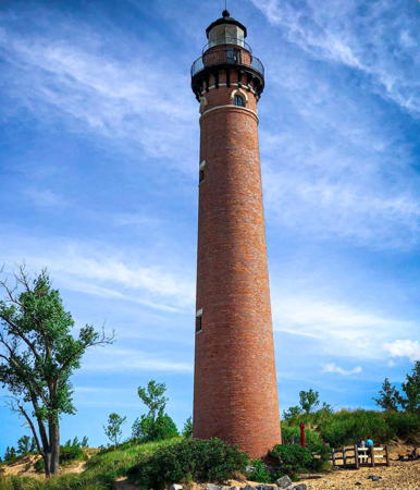
1874 (O.M. Poe). Inactive since 2014. 107 ft (32.5 m) unpainted round red brick tower with lantern and gallery; original 3rd order Sautter & Co. Fresnel lens. Lantern painted black. A classic Poe tower. Sadly, the keeper's quarters and all the other light station buildings were demolished in 1955. C.M. Hanchey's photo is at right, John Murphy has a 2021 photo, Pepper has an excellent page for the lighthouse, Wikimedia has several photos, Marinas.com has aerial photos, the Coast Guard has a 1914 photo, and Google has a satellite view and a 2017 street view. Lighthouse Digest has Jim Merkel's March 2001 article on the history of the light station. Although no one has listed this lighthouse as endangered, it stands just off the beach and appears threatened by erosion. The lighthouse was formerly painted white, but the paint was sandblasted away in 1977. In 2002 the Big Sable Point Lighthouse Keepers Association began negotiating to lease the tower; this finally happened in December 2005, allowing the lighthouse to be opened to the public in 2006. The association has since changed its name to the Sable Points Lighthouse Keepers Association. Access to the lighthouse was improved greatly in 2010 when a paved walkway through the dunes was completed. The light was deactivated in 2014. High water levels brought the lake almost to the base of the lighthouse in winter 2020. Located off Silver Lake Road near Mears, south of Ludington; ample parking is available. Site open (park entry fee), tower open daily from late May through late September (small donation requested). Owner: Michigan Department of Natural Resources. Site manager/operator: Silver Lake State Park and Sable Points Lighthouse Keepers Association (Little Sable Point Lighthouse ). ARLHS USA-443; ex-USCG 7-18645.
* Pentwater South Pierhead (2)
1937 (station established 1873). Active; focal plane 48 ft (14.5 m); red flash every 4 s. 34 ft (10 m) square pyramidal skeletal tower with a small enclosure in the lower portion. Entire tower painted red. Pepper has a page for the Pentwater lighthouses, a 2022 closeup and a 2021 photo of the two Pentwater lighthouses is available, Ryan Culby has a street view, and Google has a satellite view. The original lighthouse was a wood tower shown in a 1914 Coast Guard photo. Located at the end of the breakwater on the south side of the harbor entrance. Accessible in calm weather by walking the breakwater from Chester Street Park at the end of Chester Street in Pentwater. Good views from Mears State Park at the foot of Lowell Street on the other side of the entrance. Site open, tower closed. Owner/site manager: U.S. Coast Guard. ARLHS USA-1270; USCG 7-18630.
* Pentwater North Pierhead
1987. Active; focal plane 43 ft (13 m); green flash every 2.5 s. 35 ft (11 m) white round cylindrical steel tower with a single horizontal green band. The tower is similar to the standard "D9" pierhead towers but is more robust. Fog horn (blast every 30 s) as needed. Pepper has a page for the Pentwater lighthouses, a 2021 photo of the two Pentwater lighthouses is available, Matt Stehouwer has a 2019 street view showing both lighthouses, Kirk Schultz has a sunrise street view, and Google has a satellite view. Located at the end of the breakwater on the north side of the harbor entrance. Accessible in calm weather by walking the breakwater from Mears State Park at the foot of Lowell Street in Pentwater. Site and tower closed. Owner/site manager: U.S. Coast Guard. ARLHS USA-594; USCG 7-18620.
Little Sable Light
Little Sable Light, Stony Lake, August 2011
Flickr Creative Commons photo by C.M. Hanchey

Mason County Lighthouses
* [Ludington South Breakwater (2)]
1960s (station established 1914). Active; focal plane 30 ft (9 m); red flash every 2.5 s. 25 ft (7.5 m) white round cylindrical "D9" steel tower with a single horizontal red band. Steven Pierce has a good photo, Mason Lilly has a photo of the cross-lake ferry Badger passing the lighthouse, and Google has a satellite view. Located at the end of the breakwater; clearly visible from the North Breakwater Light. Accessible in calm weather by walking the pier. Site open, closed. Owner/site manager: U.S. Coast Guard. ARLHS USA-1081; USCG 7-18555.
*** Ludington North Breakwater (2)
1924 (station established 1914). Active; focal plane 55 ft (17 m); green light, 3 s on, 3 s off. 57 ft (17.5 m) square pyramidal steel tower, mounted on a prow-shaped concrete base designed to break the force of storm waves. Lighthouse painted white; lantern is black. The original 4th order Fresnel lens is on display at the Port of Ludington Maritime Museum. Fog horn (2 blasts every 30 s) as needed. A 2021 photo is at right, Pepper has a fine page for the lighthouse, a 2021 photo and another good photo are available, Marinas.com has aerial photos, the city also has a page for the lighthouse, the Coast Guard has a 1935 photo, and Google has a closeup street view and a satellite view. The lighthouse replaced an 1871 wood tower on the former south pier. The lighthouse has a slight lean, which was not corrected when it was renovated by the Coast Guard in 1993. In 2002 the city of Ludington, the Mason County Historical Society, and the Sable Points Lighthouse Keepers Association were working on a plan to lease the tower and the nearby Coast Guard station, which was scheduled to be replaced. However, in 2005 the lighthouse became available for transfer under NHLPA. In May 2006 the city's application was approved by the National Park Service and the transfer to city ownership occurred shortly thereafter. Also in May 2006 the light was changed from white to green to help boaters distinguish it from the lights of the town. In 2018 SPLKA restored the 14 porthole windows of the lighthouse. The Coast Guard Station was also transferred to the city; renovated as the Port of Ludington Maritime Museum it opened in August 2017 with exhibits including Fresnel lenses and other lighthouse artifacts. The Sable Points Lighthouse Keepers Association partners with the city in managing the lighthouse. Located at the end of West Ludington Avenue, just of MI 116 in downtown Ludington. Parking is available. Accessible in calm weather by walking the pier; there's also a good view during the summer from the S.S. Badger ferry linking Ludington to Manitowoc, Wisconsin. Site open, museum open daily year round, tower open daily late May through early September, weather permitting. Owner: City of Ludington. Site manager: Sable Points Lighthouse Keepers Association (Ludington North Breakwater Light ). ARLHS USA-460; USCG 7-18530.

North Breakwater Light, Ludington, August 2021
Instagram photo by kaitjac
**** Big Sable Point
1867. Active (privately maintained); focal plane 106 ft (32 m); continuous white light. 112 ft (34 m) round brick tower with lantern and gallery, encased since 1900 by steel plates, attached to a 2-story brick keeper's house; 300 mm lens. Lighthouse painted in broad black and white horizontal bands. The original 3rd order Fresnel lens is on display at the Port of Ludington Maritime Museum. Fog signal tower. The modernized keeper's house is occupied by volunteer keepers for one- or two-week stays during the summer. Jeanette Stuart's photo is at right, Pepper has a good page for the lighthouse, Marinas.com has aerial photos, Nick Kruger has a 2021 photo, the Coast Guard has a 1914 photo, Huelse has a historic postcard view, there's a beach view by Jared Alderink, and Google has a good satellite view. Lighthouse Digest has Tim Harrison's article on the history of the light station and Jim Merkel's account of its restoration. The lighthouse was formerly endangered by beach erosion: the 1908 fog signal building fell into the lake in 1941 and by 1977 the lake had breached the seawall and was within 4 ft (120 cm) of the tower. Erosion is now controlled by a seawall rebuilt and extended in 1990-93. The Sable Points Lighthouse Keepers Association works for preservation of the light station; in 1999 association members renovated the interior of the tower. Ownership of the station was transferred to the Michigan Department of Natural Resources in 2002. In 2012 a grant from the National Park Service supported restoration of 300 ft (90 m) of the seawall, and in late 2020 the Department of Natural Resources spent $130,000 to recap the seawall and add wave barriers in front of it. Restoration plans in 2021 included repainting the tower, restoring rusted sections, and replacing the roof and more than 700 original bricks. A $40,000 grant from the Michigan Lighthouse Assistance Program in 2022 funded a historic structure report to guide further work. Located beyond the end of MI 116 north of Ludington. Accessible by a 1.5 mile (2.5 km) boardwalk trail from the Pines Campground of Ludington State Park. Site open, keeper's house and tower open daily May 1 through late October; there is a small fee to climb the tower. Owner: Michigan Department of Natural Resources (Ludington State Park). Site manager/operator: Sable Points Lighthouse Keepers Association (Big Sable Point Lighthouse ). ARLHS USA-054; USCG 7-18525.

Manistee County Lighthouses
* [Manistee Main (2)]
1872 (station established 1870). Inactive 1875-1894 and since 1927. 2-story wood keeper's house; the lantern, formerly mounted on the roof, was removed in 1927. The lighthouse was replaced by the pierhead light. In 1993 it was relocated to the end of 2nd Avenue, west of Melitzer Street, where it is in use as a private residence. GLLKA's blog has an article on this light, including a current photo, and Google has a satellite view. Site closed. Owner/site manager: private. ARLHS USA-467.

Big Sable Point Light, Ludington, May 2023
Instagram photo by Jeanette Stuart
[Manistee South Breakwater (2)]
Date unknown (station established 1915). Active; focal plane 10 m (33 ft); red flash every 4 s. 8 m (26 ft) round cylindrical "D9" steel tower painted white with one red horizontal band. A photo is available and Google has a satellite view. The original lighthouse was a red skeletal tower similar to the Pentwater South Pierhead lighthouse (see above). Located at the end of the breakwater. Site and tower closed. Operator: U.S. Coast Guard. USCG 7-18460.
* Manistee North Pierhead (3)
1927 (station established 1894). Active; focal plane 55 ft (17 m); white light, 3 s on, 3 s off. 39 ft (12 m) round cylindrical cast iron tower with lantern and gallery; 300 mm lens. Lighthouse painted white; lantern roof and gallery are black. Fog horn (blast every 15 s) as needed. The lighthouse is linked to shore by the pier and by a narrow catwalk, which was restored in the early 1990s. Katy Silberger's photo is at right, Pepper has a fine page for the lighthouse, Joseph Wisdom has another good photo of the lighthouse and catwalk, Benjamin Judah has a 2018 photo, Marinas.com has aerial photos, and Google has a satellite view. The original lighthouse was built on the south pier in 1875 and relocated to the north pier in 1894; it is seen on the south pier in a historic photo from the National Archives. The Coast Guard has a 1914 photo of the second (1900) lighthouse. In 2009 the lighthouse became available for transfer under NHLPA. The City of Manistee applied for ownership in partnership with the Manistee County Historical Museum and ownership was transferred on 30 June 2011. In 2013 the state granted $20,000 to fund a historic structures report on needed restoration. The exterior of the lighthouse was repaired and repainted in spring 2016. Funds were being raised for restoration of the interior. In 2024 City Council was considering transferring management of the lighthouse to the Sable Points Lighthouse Keepers Association. Located at the end of Fifth Avenue (extension of Memorial Drive) off US 31 in downtown Manistee. Accessible by walking the pier. A nearby city park provides parking. Site open, tower closed. Operator: U.S. Coast Guard. Owner: City of Manistee. Site manager: Manistee County Historical Museum (Manistee North Pierhead Lighthouse ). ARLHS USA-468; USCG 7-18450.
Manistee North Pierhead Light
North Pierhead Light, Manistee, July 2011
Flickr Creative Commons photo by Katy Silberger
* Portage Lake North Pierhead (2 ) (relocated)
1930. Reactivated (inactive 1985-2015, now privately maintained and unofficial); focal plane about 50 ft (15 m); continuous (?) white light. Approx. 45 ft (14 m) square skeletal tower with an equipment shed in the base, mounted on a square concrete base. Lighthouse painted white, base red. Dawn Bolton has a 2021 photo, Dawn Carlson has a sunset photo, and Google has a satellite view. When this light was replaced in 1985 it was relocated to the Voyager’s Cove Marina in Manistee, where it stood until the marina was demolished in 1997. It was then purchased by the Portage Lake Association and moved to Domres Construction in Norwalk for restoration. Several possible locations for the lighthouse were considered and rejected; eventually it was installed in July 2011 at the boat launching ramp at North Point Park, on the north side of Portage Lake in Onekama Township. It was relighted on 5 July 2015. Site open, tower closed. Owner: Portage Lake Association. Site manager: Onekama Township. ARLHS USA-655.
* [Portage Lake North Pierhead (3)]
1985 (station established 1891). Active; focal plane 32 ft (10 m); green flash every 4 s. 20 ft (6 m) round cylindrical "D9" steel tower, painted white with a single green band, mounted on a square 1-story concrete base. Fog horn (blast every 15 s) on demand. David Bellmore has a photo, and Google has a satellite view. The original light here was a square wood tower; it was replaced by the skeletal tower (previous entry) in 1930 and by the present tower in 1985. Located at the end of the pier at Portage Point off MI 22 about 10 miles south of Arcadia. Accessible by walking the pier. Site open, tower closed. Owner/site manager: U.S. Coast Guard. ARLHS USA-656; USCG 7-18415.

Benzie County Lighthouses
[Frankfort South Breakwater]
Date unknown (station established 1931). Active; focal plane 46 ft (14 m); red flash every 4 s. 40 ft (12 m) round cylindrical steel "D9" tower, painted white with a single red horizontal band. Pepper has an aerial photo, Cameron Downing has a photo showing both Frankfort lights clearly, and Google has a satellite view. Site and tower closed. Owner/site manager: U.S. Coast Guard. ARLHS USA-1075; USCG 7-18385.
* Frankfort North Breakwater
1912 (relocated 1932). Active; focal plane 72 ft (22 m); continuous white light. 67 ft (20 m) square pyramidal steel tower with lantern and gallery, on a 2-story square steel base, built at the end of the breakwater. 4th order Fresnel lens in use. Lighthouse painted white; gallery and lantern roof are black. Fog horn (blast every 30 s) as needed. A photo is at right, Pepper has a page for the lighthouse, Cher Walker has a 2022 photo, Marinas.com has aerial photos, Lighthouse Digest has Tim Harrison's article on the history of the lighthouse, and Google has a street view and a satellite view. The lighthouse was built at the end of the old North Pier in 1912; it then stood 44 ft (13.5 m) tall. The Coast Guard's historic photo shows the lighthouse in its original form. In 1932 the lighthouse was moved to the new North Breakwater and lifted onto the 2-story base. There is an active Coast Guard Station at the foot of the breakwater. In 2010 the lighthouse became eligible for transfer under NHLPA and in December 2011 it was announced that the lighthouse would be transferred to the City of Frankfort. No restoration plans were announced. In 2017 the Coast Guard proposed to replace the 4th order lens with a modern LED light. In October 2021 the city launched an effort to raise $1 million to restore the lighthouse.In 2022 the Coast Guard replaced the 4th order Fresnel lens with an LED optic; the lens is offered to the city for display. Located on the north side of the Betsie Lake entrance, north of the foot of Main Street in Frankfort. Parking is available at the city beach at the end of Main Street, but it may be crowded. Accessible in calm weather by walking the breakwater; parking available nearby. Site open, tower closed. Owner/site manager: City of Frankfort. . ARLHS USA-308; USCG 7-18375.

North Breakwater Light, Frankfort, April 2008
Flickr Creative Commons photo by jimflix!
**** Point Betsie
1858. Active; focal plane 52 ft (16 m); white flash every 10 s. 37 ft (11 m) round cylindrical brick tower with lantern and gallery, attached to a 2-story brick keeper's house (1895). Lighthouse painted white, lantern black; the house is white with a red roof. The original 4th order Fresnel lens is on display at Sleeping Bear Point Maritime Museum near Glen Arbor. Corrugated steel fog signal building, painted red, with the original diaphone horn. The keeper's house, formerly used for Coast Guard housing, has been restored and furnished; the second floor is available for vacation one-week or shorter rentals. Chris Hoekstra has the 2021 photo seen at right, Pepper has a page for the lighthouse, Zachary Beland has a 2022 photo, and Google has a street view and a satellite view. The station is threatened by beach erosion, which is controlled by a seawall and several groins. For several years this beautiful lighthouse deteriorated while bureaucrats tried to figure out what to do with it. In early 2000 the Coast Guard began searching for a local group to take over control of the lighthouse. In November 2000 Benzie County agreed to take at least temporary custody of the light station and in January 2001 the county signed a lease agreement with the Coast Guard. A state grant of $10,000 in 2001 supported preparation of a preservation plan. A support group, Friends of Point Betsie Lighthouse, was launched and preservation architects were hired. During summer 2002 volunteers worked on exterior repairs to the building. In September 2003 the state awarded a $431,500 grant to launch interior restoration. Ownership of the lighthouse was transferred to the county in June 2004. Restoration of the exterior began in the fall of 2005. The lantern, formerly white with a red roof, was repainted in the original black. The restoration of the station has included the fog signal building and boathouse. In winter 2020 high water levels in the lake damaged the concrete barrier protecting the lighthouse. In 2021 the state budget included $5.2 million for restoration work at the light station. Located at the end of Point Betsie Road, off MI 22 about 5 miles (8 km) north of Frankfort; the entrance to the road is not well marked. Site open, lighthouse including tower open Thursday through Sunday from Memorial Day (late May) through mid June, daily except Tuesday mid June through Labor Day (early September), and Thursday through Monday for the rest of September and October. Owner: Benzie County. Site manager: Friends of Point Betsie Lighthouse . ARLHS USA-616; USCG 7-18370.

Point Betsie Light, Frankfort, September 2021
Google Maps photo by Chris Hoekstra

Leelanau County Lighthouses
* Manning (Robert H. Manning Memorial, Empire)
1991. Active (privately maintained); focal plane 38 ft (11.5 m); white flash every 4 s. Approx. 35 ft (11 m) round cylindrical stucco-clad wood tower, painted white; lantern painted green. Martin van Duijn has a fine 2007 closeup, Jana Labean has a 2021 photo, Pepper has a good page for the lighthouse, and Google has a street view and a satellite view. This lighthouse was built by the family and friends of Robert H. Manning, who died in 1989; he had spoken throughout his life about the need for a lighthouse at Empire. Located in Empire Beach Park on Lake Street (South Lake Michigan Drive) in Empire. Parking provided. Site open, tower closed. Owner/site manager: Village of Empire. . ARLHS USA-1268; USCG 7-18366.
** South Manitou Island (2)
1858 (station established 1840). Inactive since 1872. 2-1/2 story brick keeper's house; the light tower was removed in 1872. The building remained in use as the keeper's house for the 1872 lighthouse (next entry). ARLHS USA-1328.
** South Manitou Island (3)
1872 (O.M. Poe). Reactivated (inactive 1958-2009, now maintained by the National Park Service); focal plane about 105 ft (32 m); continuous white light. 104 ft (31.5 m) round brick tower attached to a 2-1/2 story brick keeper's house (1858). Fog signal building (1875). Pepper has a page for the lighthouse, a 2022 photo is available, Nicole Halstead has a 2019 closeup, Lighthouse Digest has Jim Merkel's October 2002 article, the Coast Guard has a 1940 photo, and Google has a satellite view. The light was deactivated in favor of a lighted buoy (USCG 7-18360) off the end of the South Manitou Island Shoal. The lighthouse was formerly endangered by beach erosion, which is now controlled by a seawall. The National Park Service, which has a page for the lighthouse, is working on restoration of the light station. In 2008 Park Service workers repaired the stairs and lantern room and installed an acrylic replica of the original 3rd order lens. Following a "Relight the Light" campaign, the lighthouse was reactivated on 30 May 2009. The Park Service recruits volunteer keepers to stay for six weeks at the station and lead tours. In 2017 rising lake levels and storms were threatening the light station through beach erosion; the park service was preparing a $1 million project to protect the area. Located on the southeast corner of the island, within walking distance of the ferry dock and island visitor center. Accessible by passenger ferry from Leland. Site open (park entry fee), visitor center open daily mid-May through October, tower open to guided tours during the summer months. Owner: U.S. National Park Service. Site manager: Sleeping Bear Dunes National Lakeshore (South Manitou Island Lighthouse ). ARLHS USA-773; USCG 7-18357.
South Manitou Island Light
South Manitou Island Light, June 2008
Flickr Creative Commons photo by tde1973
North Manitou Shoal
1935. Active; focal plane 79 ft (23 m); red flash every 15 s. 63 ft (19 m) square cylindrical steel tower with lantern and gallery, rising from a 2-story square steel keeper's house, mounted on concrete crib; solar-powered light (2000). Fog horn (two blasts every 20 s). The original box-type Fresnel lens is on display at the Sleeping Bear Point Maritime Museum of Sleeping Bear Dunes National Lakeshore. Lighthouse painted white with black trim; lantern black. Fog horn (2 blasts every 20 s) as needed. Sibling of DeTour Reef Light in Lake Huron. A drone view by Kim Kelderhouse is at right, Bryan Penberthy has a photo by Dennis Kent, Mark Rogers has a 2022 photo, Marinas.com has aerial photos, and the lighthouse is seen in Bing's satellite view. The Coast Guard has a 1934 photo. A preservation group for the lighthouse was formed in 2000 but it disbanded after estimates showed the high cost of restoring the lighthouse. In May 2015 the lighthouse became available through NHLPA. Since no eligible organizations applied for ownership the lighthouse was placed at auction in July 2016. In September it sold for $73,000 to a new preservation group, the North Manitou Light Keepers. Members of the new group began restoration and hoped to open the lighthouse to the public by 2021. Work was well underway in 2018. In February 2019 the Michigan Lighthouse Assistance Program granted $40,000 to fund a Historic Structure Report guiding the restoration, and in 2021 the Program granted $50,000 for restoration of the watch deck. With restoration nearly complete the first public tour was held on 19 June 2021, meeting the five-year-old goal. Located midway between North Manitou Island and the mainland. Accessible only by boat. Site open, tower open to guided tours (reservations required) on Saturdays late May through July. Owner/site manager: North Manitou Light Keepers . ARLHS USA-554; USCG 7-18340.
 

North Manitou Shoal Light, June 2020
Google Maps photo by Kim Kelderhouse
 
**** Grand Traverse (Northport) (2)
1858 (station established 1852). Inactive since 1972. 47 ft (14.5 m) square cylindrical brick tower rising from a 2-1/2 story brick keeper's house. Building painted white, roof red, lantern black. Brick fog signal building (1899) and oil house. The diaphone fog signal (1934), inactive since 1966, was restored in 2000 and is operated on Saturdays in the summer. Kathy Irwin's photo is at right, Pepper has a fine page for the lighthouse, Wikimedia has many photos, Jay Baker has a 2021 photo, an article in the Northern Michigan Journal has the history of the light station, Marinas.com has aerial photos, the Michigan State Archives has a historic photo, Huelse has a historic postcard view, Douglas Willett has a street view, and Google has a satellite view. The light station is a museum; a 4th order Fresnel lens used at the Alpena Light in eastern Michigan is on display. The Grand Traverse Lighthouse Foundation has worked since 1987 to restore and maintain the lighthouse. In 2001 a state grant of $14,500, matched by private donations, was used to repaint the building. The 150th anniversary of the light station was celebrated on July 20, 2002. Lighthouse Digest has Jim Merkel's March 2003 feature on preservation efforts. Ownership of the light station was transferred to the state on September 22, 2003. In 2006 an urgent appeal was made for $45,000 needed for urgent repair of moisture damage to the foundation and floor joists. Since 2004 volunteer keepers spend one-week tours of duty at the lighthouse April through December, and in 2009 the lighthouse was opened for one-night stays during the winter season. Located at the end of MI 201 on the point separating Traverse Bay from Lake Michigan. Ample parking is available. Site open (state park entry fee), museum and tower open daily May through October, also weekends in November. Owner: Michigan Dept. of Natural Resources (Leelanau State Park). Site manager: Grand Traverse Lighthouse Museum . ARLHS USA-332.
* Grand Traverse (Northport) (3)
1972 (station established 1852). Active; focal plane 50 ft (15 m); white flash every 6 s. 41 ft (12.5 m) square cylindrical steel skeletal tower. Pepper has a photo, Douglas Willett has a street view, and Google has a satellite view. Located on the north side of the historic lighthouse. Site open, tower closed. USCG 7-18110
Grand Traverse Light
Grand Traverse Light, Northport, September 2009
Flickr Creative Commons photo by Kathy Irwin
South Fox Island (1)
1867. Inactive since 1934. 45 ft (13.5 m) square cylindrical brick tower with lantern and gallery, attached church-style to a brick keeper's house. The 4th order Fresnel lens from this lighthouse is now displayed in the tower of the Old Presque Isle Light (see the Northeastern Lower Peninsula page). Building painted white, lantern white with a red roof. A recent photo is at right, Pepper has a page for the lighthouse, Karen Wells has a closeup 2023 photo, Ken Scott has a 2009 aerial view, Bash has a 2005 view from the lake, and Google has a satellite view. Located in the center of Lake Michigan midway between the Manitou Islands and Beaver Island, South Fox Island is about 5 m (8 km) long and 1.5 mi (2.5 km ) wide. For many years the lighthouse was abandoned and endangered by neglect. In October 2000 the state proposed a land swap with David Johnson, the developer who owns about 2/3 of the island; the swap would have placed the light station under private control. Strong opposition from preservationists led the developer to scale back his plans in November 2001, leaving the station in state ownership. In late 2004 the Fox Island Lighthouse Association was organized to work for restoration of the South Fox Island lighthouses. Volunteers have been working steadily since then and there has been considerable progress in stabilizing and refurbishing the light station buildings. The windows were replaced in 2015. Located at the southernmost tip of the island. Accessible only by boat; passenger ferry service is available and camping on the island is permitted. Site open, tower closed. Owner: Michigan Department of Natural Resources. Site manager: Fox Island Lighthouse Association . ARLHS USA-771.
South Fox Island (2)
1905 (relocated here in 1934). Inactive since 1959. 100 ft (30.5 m) square pyramidal cast iron "Sanibel class" skeletal tower with central cylinder, lantern, and gallery. Originally built in 1905 at Sapelo Island, Georgia, the lighthouse was dismantled and transferred to this site in 1934. Michael Mathewson has a 2010 photo and Google has a satellite view. The Coast Guard has a photo of South Fox Island showing both towers as well as a historic photo of this tower at Sapelo Island. When it was active, the lighthouse was painted white with a black lantern and watch room; today it is mostly black with rust. In late 2004 the Fox Island Lighthouse Association was organized to work for restoration of both South Fox Island lighthouses. Located adjacent to the earlier lighthouse. Site open, tower closed. Owner: Michigan Department of Natural Resources. Site manager: Fox Island Lighthouse Association . ARLHS USA-1327.
 

1867 South Fox Island Light, Leelanau County
pboto posted by Fox Island Lighthouse Association
 

Grand Traverse County Lighthouses
**** Mission Point (1)
1870. Inactive since 1938 but charted as a landmark. 30 ft (9 m) square cylindrical wood tower mounted schoolhouse-style on a 1-1/2 story wood keeper's house. Building painted white. Mike Loyd's 2023 photo is at right, Anderson's page has good photos, Pepper has a good page for the light station, John Inman has a 2021 photo, Wikipedia's article has a photo, Marinas.com has aerial photos, the Coast Guard has a historic photo, Huelse has a historic postcard view, and Google has a street view and a satellite view. Famous for its location precisely on the 45th parallel, the lighthouse was discontinued because it fails to warn ships away from extensive shoals north of the point. It was transferred first to the state in the 1940s and then to Peninsula Township in 1948. It served for many years as a park manager's residence, but in 2008 it opened to the public. Volunteer keepers are needed (year round) for stays in the rear of the structure. In 2015 a state grant of $44,732 supported foundation repairs and the relocation of an outbuilding to its original location near the lighthouse. In 2020 historically accurate shutters were installed in time for the celebration of the lighthouses's 150th anniversary. In 2024 lighthoue managers were planning new boardwalks, beach stairs, and a replica of the historic boathouse. Located at the end of MI 37 at Old Mission Point, which divides Traverse Bay into east and west bays. Limited parking available. Site open, building and tower open daily May through October and Friday through Sunday in November. Owner: Peninsula Township. Site manager: Old Mission Peninsula Historical Society (Mission Point Lighthouse ). ARLHS USA-504.
Mission Point (3)
Date unknown. Active; focal plane 41 ft (12.5 m); white flash every 6 s. 25 ft (7.5 m) round cylindrical steel tower rising from a square 1-story equipment room and mounted on a circular crib. Marinas.com has aerial photos and Bing has a distant satellite view. The cylindrical tower replaced a square steel skeletal tower. Located at the end of long shoal northwest of the old lighthouse; easily but distantly seen from the shore. Accessible only by boat. Site and tower closed. Owner/site manager: U.S. Coast Guard. ARLHS USA-1098; USCG 7-18145.

Mission Point Light, Peninsula Township, October 2023
Instagram photo by Mike Loyd

Charlevoix County Lighthouses
Charlevoix County includes Beaver Island, the largest island of Lake Michigan. The island is 13 mi (21 km) long and 6 mi (10 km) wide; its permanent population of about 550 is augmented by summer visitors. The island is accessible in season by ferry from Charlevoix (reservations strongly suggested).

* Charlevoix South Pierhead (2)
1948 (station established 1885). Active; focal plane 41 ft (12.5 m); red flash every 4 s. Approx. 40 ft (12 m) square pyramidal steel skeletal tower, upper 2/3 enclosed. Lighthouse painted red, lantern black. Fog horn (blast every 30 s) as needed. Pepper has a page for the lighthouse, Juli Pannone has the 2021 photo at right, Marinas.com has aerial photos, and Google has good street view and a satellite view. The original (1885) wood tower was built on the north pier and relocated to the south pier in 1914. Its lantern was transferred to the present lighthouse in 1948. The keeper's house was demolished in 1984 and the land on which it stood is now a city park. In 2005 the lighthouse became available for transfer under NHLPA and in 2008 it was transferred to the City of Charlevoix. In 2008 windows were replaced in a project to make the structure watertight. In 2009 the formerly-white lighthouse was repainted red, its color prior to 1968. A July 2010 photo shows the new color. Unfortunately the new paint faded rapidly and the lighthouse had to be painted again in 2016. Restoration of the interior is in progress. An interpretive sign was installed at the base of the lighthouse in October 2017. Located on the pierhead at the foot of Grant Street in downtown Charlevoix, 2 blocks west of US 31. Parking available near the lighthouse. Site open, tower closed. Operator: U.S. Coast Guard. Owner: City of Charlevoix. Site manager: Charlevoix Historical Society (South Pier Lighthouse ). ARLHS USA-156; USCG 7-17925.
** St. James (Beaver Island Harbor, Whiskey Point) (2)
1870 (station established 1856). Active; focal plane 38 ft (11.5 m); red light, 3 s on, 3 s off. 41 ft (12.5 m) round cylindrical brick tower with lantern and gallery; original 4th order Fresnel lens. Tower painted white, lantern black. The keeper's house, formerly attached, was demolished in the 1940s. A 2018 photo shows the light freshly repainted, Kelcie Herald has a 2021 photo of the light in action, Marinas.com has aerial photos, the Coast Guard has a historic photo showing the lighthouse attached to the keeper's house, and Google has a street view and a satellite view. In October 2000 the township secured a ten-year lease on the structure. In 2003 an inspection by GLLKA found "the tower to be in somewhat poor condition, with moisture causing serious spalling of the bricks on the tower exterior," according to Terry Pepper. Ownership of the lighthouse was transferred to the township under NHLPA in 2005. Clearly there has been restoration work since then and the lighthouse appears in good shape at present. Traverse magazine has an article on Elizabeth Whitney Williams, a nineteenth century keeper. Located at the end of Michigan Street at the east side of the harbor entrance in St. James. Site open, tower open Wednesday and Saturdays during the summer. Operator: U.S. Coast Guard. Owner/site manager: St. James Township. . ARLHS USA-047; USCG 7-17845.
 

Charlevoix South Pierhead Light, Charlevoix, August 2021
Google Maps photo by Juli Pannone
 
** Beaver Head (Beaver Island) (2)
1858 (station established 1852). Inactive since 1962. 46 ft (14 m) round cylindrical brick tower attached to a 2-story brick keeper's house (1866). The original 4th order Fresnel lens is displayed in the keeper's house. The tower is unpainted light tan brick; the lantern is painted green with a red roof. Brick fog signal building (1910). Zach Wilkinson's photo is at right, Pepper has a good page for the light station, Dawn Morgan has a 2021 photo, Bash has a photo of the station, the Coast Guard has a historic photo, and Google has a street view and a satellite view. The original, poorly-constructed lighthouse collapsed in 1857. In 1975 the Charlevoix school district (on the mainland) bought the station for $1 to establish an alternative school for youth aged 16-21. Beginning in 1978 the station was restored in a series of summer work/study programs and then opened as a school. In 2003 a grant was obtained to repair spalling of the exterior brick work and in 2005 the state granted $23,000 for restoration of the oil house. The school closed in June 2016 due to loss of federal funding. In October 2018 Charlevoix County and Networks Northwest (an economic development organization that had supported the school for years) announced a deal to purchase the light station from the school system and this sale was completed in July 2019. New uses for the light station are being considered. In 2019-20 high water levels in Lake Michigan threatened the fog signal building and the county spent $30,000 to place additional riprap around the building to protect it. In 2020 the county was seeking grant funding to replace the roof of the keeper's house. In 2022 students from Eastern Michigan University’s Historic Preservation graduate program spent tome doing some preservation work and writing a report recommending further action. The light station is currently an undeveloped county park administered by the county's Parks Commission. Located near the southern end of the island. Island accessible in season by ferry from Charlevoix. Site open, tower open daily (it is unlocked) during the summer months. Owner/site manager: Charlevoix County. . ARLHS USA-046.
Gull Island (2)
1980s (station establishment date unknown). Active; focal plane 77 ft (23.5 m); white flash every 6 s. 73 ft (22 m) triangular skeletal tower. The tower carries two diamond-shaped daymarks colored in a red and white checkerboard pattern. No photo available but Google has a satellite view. The original lighthouse was an 88 ft (27 m) hexagonal skeletal tower with lantern and gallery. Gull Island, a small island about 15 mi (25 km) west of Beaver Island, is a bird sanctuary and is closed to the public. (It should not be confused with another Gull Island off Northport.) Located at the northern tip of Gull Island. Accessible only by boat. Site and tower closed. Owner: U.S. Coast Guard. Site manager: U.S. Fish and Wildlife Service (Michigan Islands National Wildlife Refuge). ARLHS USA-1115; USCG 7-21530.

Beaver Head Light, Beaver Island, August 2020
Google Maps photo
by Zach Wilkinson
Ojibwa (Squaw) Island
1892. Inactive since 1928 but charted as a landmark. Approx. 15 m (50 ft) octagonal cylindrical brick tower attached to a 2-story brick Norman Gothic keeper's house. The building is unpainted red brick; lantern is painted black. Brick fog signal building and brick oil house. Pepper has a page for the lighthouse, Eric VanDuyn has a 2017 photo, a good closeup is available, Lighthouse Digest has Don Farrant's 1997 article on the history of the light station, the Coast Guard has a 1913 photo, and Google has a satellite view. This lighthouse, long abandoned, fell into very poor condition. At some point the island and lighthouse were sold into private ownership and eventually came into the hands of Tom Child and his family. In the fall of 2016 the Childs put a new roof on the building and made some exterior repairs; Lighthouse Digest has an article on this project. But within days they put the island and lighthouse for sale for $1.5 million. The island has been sold but the new owners are not known. In 2022 the Department of the Interior changed the name of the island officially from Squaw Island to Ojibwa Island. Located on a remote island 6 miles (10 km) northwest of St. James (Beaver Island). Accessible only by boat. Site and tower closed. Owner/site manager: private. ARLHS USA-786.

Emmet County Lighthouses
Petoskey (5?)
Date unknown (station established 1899). Active; focal plane 44 ft (13.5 m); red flash every 2.5 s. 33 ft (10 m) round "D9" round cylindrical steel tower, painted white with one red horizontal band, on a square 1-story concrete base. Ann Graves has a closeup 2020 photo, a distant 2017 photo is available, Craig Smith has a street view, and Google has a satellite view. This is one of many modern pierhead lights of similar design throughout the Great Lakes, but it is highly visible and is regarded locally as a lighthouse. In the winter of 2006 a violent storm damaged the breakwater but the light was not affected. The original light was on a post. The second light, built in 1912, was a hexagonal "pagoda" style cast iron tower; it was swept away by a storm in 1924. It was replaced by a steel skeletal tower in 1930. In 2009 members of the Great Lakes Lighthouse Keepers Association proposed to reconstuct the shell of the 1912 lighthouse around the modern light. The Coast Guard rejected this proposal because it does not allow privately maintained lights on major piers. In September 2010 the city council accepted a GLLKA plan to build the replica in Quarry Park, overlooking the harbor on Lewis Street north of Rose Street. The proposed light would have a focal plane of about 90 ft (27 m) and might serve as an aid to navigation. GLLKA was trying to raise the estimated $300,000 needed for the project, but so far nothing seems to have come from this effort. Located at the end of the breakwater at the entrance to the harbor. Site and tower closed. Owner/site manager: U.S. Coast Guard. . ARLHS USA-1085; USCG 7-17915.
* State Street Pier (Harbor Springs)
1963? Active (privately maintained); focal plane 38 ft (11.5 m); continuous red light. Navigation light mounted atop a cupola centered on the roof of a restaurant on the pier. Charles Dawley has a closeup photo and Google has a street view and a satellite view. This light was installed around the time the Harbor Point lighthouse was deactivated. Located on East Bay Street at the foot of State Street, off MI 119 in downtown Harbor Springs. Site and restaurant open. Site manager: Stafford's Pier Restaurant. ARLHS USA-1326; USCG 7-17865.
Little Traverse (Harbor Point) (1)
1884. Inactive since 1963. 40 ft (12 m) square cylindrical brick tower, unpainted, attached church-style to a 1-1/2 story brick keeper's house. Lantern painted white with a red roof. The original 4th order Fresnel lens is still mounted in the tower and a very rare square pyramidal wood fog bell tower (1896) with the original striking mechanism intact is on the point east of the lighthouse. A photo is at right, Pepper has a good page for the lighthouse, Dawn Carlson has a closeup photo, a 2023 photo is available, Marinas.com has aerial photos, the Coast Guard has a 1925 photo, and Google has a satellite view. The lighthouse is located at the end of Harbor Point, a gated community on a spit sheltering Harbor Springs. There's a good view from the Little Traverse Bay Ferry between Harbor Springs and Petoskey; also visible on harbor tours from Petoskey available in season. Site and tower generally closed; in recent years guided tours have been available once or twice each year. Owner/site manager: Harbor Point Association. . ARLHS USA-444.

Little Traverse Light, Harbor Springs, July 2020
Flickr photo copyright Selector Jonathon Photography
used by permission
Little Traverse (Harbor Point) (2)
1963. Active; focal plane 73 ft (22 m), green flash every 6 s. 72 ft (22 m) square steel skeletal tower with gallery, painted white. Dawn Carlson has a photo showing this tower and the historic lighthouse and Google has a satellite view. Located on the point southeast of the lighthouse. USCG 7-17855.
Ile aux Galets (Skillagalee) (3)
1888 (station established 1850). Active; focal plane 58 ft (17.5 m); white flash every 6 s. 58 ft (17.5 m) octagonal brick tower; 300 mm lens (1969). Lighthouse painted white; lantern, watch room, and gallery black. The keeper's house (formerly attached) and all other light station buildings were demolished in 1969. Sibling of the Port Sanilac Light in southeastern Michigan. Pepper has a page for the lighthouse, Kevin Morgeson has the 2015 photo at right, Derek Byrne has a 2021 photo, Marinas.com has aerial photos, the Coast Guard has a historic photo of the complete station, and Google has a satellite view. The original lighthouse had a lantern on a keeper's house; it was replaced in 1868 by a 100 ft (30.5 m) brick tower. That tall tower was torn down and replaced in 1888 when it appeared it would be lost to beach erosion. The light station buildings other than the light tower were demolished in 1969. The General Services Administration placed the lighthouse on auction sale in July 2015 and it sold in September for $23,250. The new owner is Bill Collins, who also owns the Manistique Lighthouse in Upper Michigan and the Liston Rear Range Lighthouse in Delaware. Collins has started a preservation organization called Light Keepers Preservation. Note: "Skillagalee" is an English garbling of the original French name Île aux Galets (Isle of Pebbles). Located on a low island, the highest point of a long sandy shoal, about 8 miles (13 km) west northwest of Cross Village. Accessible only by boat in dangerous waters, and there are no facilities for landing on the island. Site and tower closed. Operator: U.S. Coast Guard. Owner/site manager: Light Keepers Preservation, Inc. . ARLHS USA-399; USCG 7-17795.


Île aux Galets (Skillagalee) Light, Lake Michigan, July 2015
Google Maps photo
by Kevin Morgeson

Grays Reef
1937 (lightship station established 1891). Active; focal plane 82 ft (25 m); red flash every 10 s. 65 ft (20 m) octagonal cylindrical Art Deco steel tower on square concrete keeper's house, mounted on concrete and stone crib; solar-powered 190 mm lens. The tower is surmounted by a tall antenna. Lighthouse painted white, lantern black. Fog horn (2 blasts every 30 s) as needed. The original 3-1/2 order Fresnel lens is on display at the Harsha House Museum in Charlevoix. Sibling of the Minneapolis Shoal Light (see Southern Upper Peninsula). Pepper has a page for the lighthouse, Brandon Rose has a 2020 photo, Marinas.com has aerial photos, and the Coast Guard has a 1948 photo, but the lighthouse appears only as a smudge in Bing's satellite view. This light marks the south end of the Grays Reef Channel, a narrow passage through an underwater ridge extending from Waugoschance Point to the Beaver Islands. In 2013 the lighthouse became available for transfer under NHLPA. Since no eligible organizations applied for ownership, the lighthouse was placed at auction in July 2016; it sold in October for $52,777 to Boston philanthropist Bobby Sager, who also owns the Minots Ledge Lighthouse in Massachusetts and the Boon Island Lighthouse in Maine. Located 4 miles (6.5 km) west southwest of Waugoshance Island. Accessible only by boat. Site and tower closed. Owner/site manager: private. . ARLHS USA-343; USCG 7-17775.
White Shoal
1910 (lightship station established 1891). Active; focal plane 125 ft (38 m); white flash every 4 s. 121 ft (37 m) round steel and terra cotta block tower (brick lined), incorporating keeper's house, mounted on a timber and concrete crib; 190 mm lens. The tower is painted with distinctive red and white stripes in a "candy-stripe" spiral pattern (it is the only U.S. lighthouse with this daymark); the lantern and gallery are red. Fog horn (blast every 30 s) as needed. The original bivalve 2nd order Fresnel lens, removed in 1897, is on display at the Great Lakes Shipwreck Museum at Whitefish Point on the Upper Peninsula. Jade Sauve's 2017 photo is at right, Bash has 2007 photo taken on a GLLKA-sponsored lighthouse cruise, Pepper has a good page for the lighthouse, Jerry Rhodes has a 2019 photo, and Marinas.com has aerial photos, but the lighthouse appears only as a smudge in Bing's satellite view. The Coast Guard has a historic photo of the lighthouse nearing completion. This light marks the north end of the Grays Reef Channel, where ships must make a right-angle turn. The distinctive red and white daymark was applied in 1954. In May 2014 the lighthouse became available for transfer under NHLPA. Since no eligible organizations applied for ownership, the lighthouse was placed at auction in July 2016; it sold in September for $110,009. The new owners, Brent Tompkins and Mike Lynch, launched the White Shoal Light Historical Preservation Society and announced their plans to restore the lighthouse for overnight accommodations and public tours. They estimate the restoration will require five years and about $3 million. On New Years Day 2019 they announced that the partially-restored lighthouse would open to public tours starting in July. Tours have been suspended for 2022-23 to allow for more extensive restoration work, but they are planned to resume in July 2024. Located 2.6 miles (4.2 km) northwest of Waugoshance Island. Site open, tower closed. Owner/site manager: White Shoal Light Historical Preservation Society . ARLHS USA-886; USCG 7-17750.

White Shoal Light, Lake Michigan, August 2017
Instagram photo by Jade Sauve
Waugoshance
1851. Inactive since 1912 but charted as a landmark. 76 ft (23 m) ruined round brick tower, formerly encased in iron, mounted on a stone crib. Very rare original "birdcage" lantern. A closeup photo is at the bottom of this page, a good 2007 photo is available, Pepper has a page for the lighthouse, Brandon Rose has a 2020 photo, and Marinas.com has aerial photos, but the lighthouse is not seen in Bing's satellite view of the area. The National Archives has a 1913 photo of the complete station. This lighthouse is too far east to be an effective marker for the Grays Reef Channel; it was abandoned after it was replaced by the White Shoal Light. Previously used for bombing and strafing practice, the lighthouse is gravely endangered and deteriorating; it is a longtime resident on the Lighthouse Digest Doomsday List. Rose has a 2020 closeup showing the crumbling state of the tower. The Waugoshance Lighthouse Preservation Society began working on the preservation of the lighthouse. The Coast Guard authorized fundraising to stabilize the building and the Society was negotiating a lease on the light station. In 2009 the lighthouse became available for transfer under NHLPA, and in October 2011 ownership was awarded to the preservation society. In September 2012 the society announced that it had arranged funding for the historic structures report needed before restoration can begin. However, in 2019 storms and high lake levels damaged the foundation of the lighthouse, raising fears for its survival. In 2020 the Society concluded the lighthouse could not be saved, and at the end of year the organization was dissolved. Located about 2 miles (3 km) northwest of Waugoshance Island. Accessible only by boat in dangerous waters. Site and tower closed. . ARLHS USA-874.
*** McGulpin Point (McGulpins Point)
1869. Reactivated (inactive 1906-2009, now maintained by the county); focal plane 108 ft (33 m); white flash every 4 s. Approx. 40 ft (12 m) octagonal cylindrical brick tower with lantern and gallery attached to a 2-story Norman Gothic brick keeper's house. Peter Ciro's photo is at right, Pepper has a fine page for the light station, Anderson also has a good page for the lighthouse, Matt Follick has an excellent photo, and Google has a street view and a satellite view. For many years this lighthouse was very well maintained as a private residence. Bash's 2006 photo shows the lighthouse as it appeared in private ownership; the original lantern had been removed when the lighthouse was deactivated. In 2005 the property was for sale for $1.75 million; by early 2008 the price had been lowered to $975,000. With no buyers in sight, Emmet County Commissioners voted in June to purchase the property for $720,000. In April 2009 the Commissioners agreed to purchase two adjoining lots for future parking and a possible museum. Also in April 2009 a replica lantern was installed and a relighting celebration was held on May 30. The keeper's house house is being developed as a museum and a neighboring building (added after the lighthouse was sold) has been renovated for overnight accommodations. The county has a web page for the lighthouse. In spring 2023 the lighthouse was refreshed with an exterior restoration and interior repainting. Located at the end of Headlands Road about 3 miles (5 km) west of Mackinaw City. Parking is provided but is somewhat limited. Site open, lighthouse and tower open daily mid May to mid October. Owner: Emmet County. Site manager: McGulpin Point Lighthouse . ARLHS USA-487; USCG 7-12651.

McGulpin Point Light, Mackinaw City, May 2016
Flickr Creative Commons photo by Peter Ciro
**** Mackinac Point
1892 (John Peter Schmitt). Inactive since 1957. 40 ft (12 m) round cylindrical brick tower attached to 2-story brick Tudor Revival keeper's house. Building unpainted with red roofs; lantern painted black. The original 4th order Sautter, Lemonier & Co. Fresnel lens, rediscovered in storage after being lost for many years, was returned for display in May 2003. Brick fog signal building (1907). Keith Ewing's photo is at right, Pepper has a good page for the lighthouse, Christina Nuss has a 2022 photo, an excellent closeup photo is available, Marinas.com has aerial photos, Huelse has a historic postcard view, Ben Woodworth has a January 2017 street view, and Google has a satellite view. The Coast Guard has a 1945 aerial view of the light station. The Mackinac Island State Park Commission purchased Old Point Mackinac Lighthouse in 1960 and added it to Michilimackinac State Park. After some restoration work the lighthouse was opened to the public in 1972 but budget reductions forced its closure in 1990. After being closed for a decade the light station was in need of extensive restoration by 2000. Efforts began in 2001 to raise $2.5 million needed to restore the site. In the summer of 2002 state grants repaired the roof and replaced the windows. The lighthouse reopened to visitors on June 12, 2004. In early 2005 the station's barn, which had been relocated, was returned. In late 2006 restoration work began on the barn. An exterior restoration in 2017 replaced spalled bricks in the walls of the lighthouse. Restoration of the keeper's apartment on the second floor was completed in July 2020. Located at the end of Huron Street in Mackinaw City, practically under the "Mighty Mac" (I-75) bridge over the Straits of Mackinac (the lighthouse was deactivated when the bridge was completed in 1957). Site open, fog signal building open daily during the summer, lighthouse and tower open daily from early May to early October. Owner: Mackinac Island State Park Commission. Site manager: Mackinac State Historic Parks (Old Mackinac Point Lighthouse ). ARLHS USA-463.
Mackinac Point Light
Mackinac Point Light, Mackinaw City, August 2010
Flickr Creative Commons photo by Keith Ewing

Inland Lighthouse: Ionia County
* Jordan Lake
1938. Inactive. 37 ft (11 m) hexagonal concrete tower with lantern and gallery, attached to a 2-story residence. Originally painted white, the tower is now covered with a fake stone veneer. Justin Varner has a photo and Google has a street view but a tree conceals the lighthouse in Google's satellite view. The lighthouse was built as a free-standing tower by Ernest G. York as part of a boat-rental and beach-concession business. A red flashing light was displayed for many years. Lighthouse Digest has a historic postcard view. Located on Lakeview Drive in Lake Odessa, off MI 50. Site and tower closed (private property), but the lighthouse can be seen from nearby. Owner/site manager: private.

Information available on lost lighthouses

  • Charlevoix North Pierhead (1885-?). Anderson discusses this light on his Charlevoix page and has a historic photo. The original lighthouse was relocated to the south pier in 1914 (see above) and replaced by a tall skeletal tower. There is a light on a post on this pier today. USCG 7-17920.
  • Kalamazoo (1839-1914, inactive 1876-1892), at the original mouth of the Kalamazoo River. The second (1859) lighthouse was destroyed by a tornado on 3 April 1956. Salvaged portions of the 1859 building are incorporated in a faux lighthouse on the site (private residence). Lighthouse Digest has Jerry Biggs's article on the history of the light station. ARLHS USA-1265.
  • Frankfort South Pier (1873-1932), Frankfort. Anderson discusses this light on his Frankfort page and has a historic postcard photo. The lighthouse was demolished.
  • Ludington South Pier (1870-1914), Ludington. Anderson discusses this light on his Ludington page and has a historic photo. The pier has been removed.
  • Muskegon Main (1851-1970s), Muskegon. The second (1871) lighthouse was deactivated in 1903 and demolished in the 1970s to make way for new construction at the Coast Guard station. Anderson has an 1883 photo.
  • New Buffalo (1839-1859), Berrien County near the Indiana state line. The lighthouse was lost to beach erosion. ARLHS USA-950.
  • North Manitou Island (1898-1970s), Leelanau County. Deactivated in 1935 in favor of the North Manitou Shoal lighthouse. The lighthouse was lost to beach erosion in 1942. ARLHS USA-1269.
  • St. Joseph Main (1831-1955), St. Joseph. The second (1859) lighthouse was deactivated in 1919 and demolished in 1955. Anderson has a historic photo.
  • South Haven Inner (1916-1960s), South Haven. Anderson's South Haven page has a 1949 photo. The lighthouse was removed when the range was deactivated.
  • White River South Pierhead (1871-1980s). Anderson discusses this station on his White River page. The second (1930) lighthouse was replaced by a light on a post. USCG 7-18655.

Waugoshance Light, Lake Michigan, July 2015
Wikimedia Creative Commons photo by Ddieffen

Notable faux lighthouses:

Adjoining pages: North: Southern Upper Peninsula | East: Northeastern Lower Peninsula | South : Indiana

Return to the Lighthouse Directory index

Checked and revised December 7, 2023. Lighthouses: 47. Site copyright 2023 Russ Rowlett and the University of North Carolina at Chapel Hill.