Lighthouses of Japan: Miyagi

The nation of Japan, known in Japanese as Nihon or Nippon (日本), occupies an archipelago off the east coast of Asia. The four main islands are Hokkaidō in the north, Honshū (the largest) in the center, Shikoku in the south, and Kyūshū in the southwest. The country includes thousands of other islands of all sizes; among them the Ryūkyū (Nansei) Islands are a long chain extending to the southwest and including the large island of Okinawa, and the Nanpō Islands are another long chain extending south into the Pacific Ocean. Much of Japan is mountainous but the coastal regions are densely populated and urbanized; the country's population is about 126 million.

Japan is divided into 47 prefectures. This page lists lighthouses of Miyagi Prefecture on the northeastern coast of Honshū. The northern coast of Miyagi, facing east on the Pacific Ocean, is rugged and spectacular. The southern coast faces Sendai Bay and includes the important ports of Ishinomaki and Sendai.

This coast was devastated by the great Tōhoku earthquake and tsunami of 11 March 2011; the epicenter of this mammoth magnitude 9.0 quake was about 70 km (43 mi) east of the Miyagi coast. The major lighthouses are high enough above the sea to escape the tsunami; all were damaged by the earthquake to some extent but they have been returned to service. A number of harbor lights were overturned or destroyed by the tsunami.

In Japanese the word for a lighthouse is tōdai or toudai (灯台). The words saki and misaki are for capes and headlands, hana ("nose") is a promontory, hantō is a peninsula, shima (also spelled sima or jima) is an island, bae is a reef, iwa or shi is a rocky reef, amase or se is a shoal, wan is a bay, nada is a sound or basin, kaikyō is a strait, kawa is a river, and or minato is a harbor.

Lighthouses in Japan are operated and maintained by the Japanese Coast Guard's Maritime Safety Agency. On Honshū there is usually one Coast Guard Section Office in each prefecture. That is the case in this region, with the Miyagi office located in Shiogama.

ARLHS numbers are from the ARLHS World List of Lights. JCG numbers are the Japanese Coast Guard's light list numbers. Admiralty numbers are from volume M of the Admiralty List of Lights & Fog Signals. U.S. NGA List numbers are from Publication 112.

General Sources
Lighthouses in Japan - Miyagi
A site providing photos and data for most major Japanese lighthouses.
Lighthouse-Japan.com - Miyagi
Another comprehensive site with photos and notes from visits to many lighthouses.
Lighthouses in Miyagi Prefecture
This site has photos from recent visits with notes about access; it is cited below as FOAL (Form of a Lighthouse).
Lighthouse Visits
A fourth site with photos of most Japanese lighthouses.
Second Region Lighthouse Story
Posted by the Coast Guard region office in Aomori, an interactive map linking to information on the major lighthouses.
Misty's Japanese Lighthouse Tour - Miyagi
Photos and brief notes for lighthouses in all parts of the country.
Lighthouses in Miyagi Prefecture
Photos by various photographers available from Wikimedia.
Online List of Lights - Japan
Photos by various photographers posted by Alexander Trabas.
Navionics Charts
Navigation chart for Miyagi.

Iwai Saki Light
Iwai Saki Light, Kesennuma
Japanese Coast Guard Miyagi Office photo

Kesennuma City Lighthouses
The Rikuzen Coast of northeastern Miyagi Prefecture is an extension of the Rikuchū Coast of Iwate Prefecture, with the same rugged topography: a series of steep headlands jutting eastward into the Pacific. Sheltered between two of these headlands, Kesennuma is a fishing port with a population of about 70,000. It was damaged severely by the 2011 earthquake, tsunami, and subsequent fires.
* Rikuzen O Saki (Rikuzen Osaki Saki)
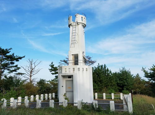
1953. Active; focal plane 42 m (138 ft); white light, 4 s on, 4 s off. 13 m (43 ft) round concrete post, rising from a square 1-story concrete equipment shelter. Entire lighthouse is white. A Coast Guard photo is at right, Lighthouses of Japan also has a photo, a 2018 photo and a 2019 closeup are available, FOAL has 2019 photos, and Google has a satellite view. Located at the tip of the Karakuwa Peninsula about 15 km (9 mi) southeast of Kesennuma. Accessible by a short walk from the Osaki Shrine; parking is available at the shrine. Site open, tower closed. . ARLHS JPN-509; JCG-1699; Admiralty M6570; NGA 4236.
#Rikuzen Nagasaki Kō (Yama Bana) (1)
Date unknown. Destroyed.This was a 9.5 m (31 ft) concrete post attached to a square 1-story concrete equipment building. Entire lighthouse is red. This lighthouse was destroyed by the tsunami and the breakwater was damaged badly. Google's 2014 street view and satellite view show that the breakwater has been repaired; the light has first replaced by a buoy and then in 2015 by a light on a simple post as seen on FOAL's page for the light and Google's 2019 street view. Located at the end of the main breakwater of Nagasaki harbor, on the east side of Iō Shima. Site status unknown. ARLHS JPN-1171; ex-NGA 4244. Current light: JCG-1699.5; Admiralty M6569.
Kara Shima
1966. Active; focal plane 34 m (112 ft); white flash every 5 s. 10 m (33 ft) round hourglass-shaped concrete tower with gallery. Entire lighthouse is white. FOAL has views from the sea and Google has a satellite view. Located on a small island in the eastern arm of Kesennuma Wan, about 4 km (2.5 mi) northwest of Rikuzen O Saki. Accessible only by boat. Site status unknown. ARLHS JPN-1151; JCG-1700; Admiralty M6568; NGA 4240.
Shibitachi Nakane
Date unknown. Active; focal plane 11 m (36 ft); one short and one long red flash every 8 s. 10 m (33 ft) concrete post attached to a square 1-story concrete equipment building. Entire lighthouse is red. FOAL has photos (bottom of the page), Takeshi Yamada has distant view, and Google has a sea view and a satellite view. Located on a rock in the upper end of the eastern arm of Kesennuma Wan. Accessible only by boat. Site open, tower closed. JCG-1701; Admiralty M6567.5; NGA 4252.
Tō Wan (Kesennuma, Yoroi Saki)
1981. Active; focal plane 28 m (92 ft); continuous light, white, red or green depending on direction. 10 m (33 ft) round cylindrical concrete tower, rising from one end of a 1-story building and supporting a large square room. FOAL's page has closeup photos, and Google has a sea view and a satellite view. Located at the head of the eastern arm of Kesennuma Wan, guiding ships toward the port. Accessible by a hiking trail but some local guidance may be needed. . ARLHS JPN-254; JCG-1702; Admiralty M6567.4; NGA 4272.
Rikuzen Osaki Saki Light
Rikuzen Osaki Saki Light, Kesennuma
Japanese Coast Guard Miyagi Office photo
Banshone (Bansho Ne)
Date unknown. Active; focal plane 9.5 m (31 ft); green flash every 3 s; also a continuous white spotlight (JCG-1703.1) illuminates the surrounding reef. 8.5 m (28 ft) concrete post attached to a small equipment building. Entire post is green. Takeshi Yamada has a 2020 closeup photo and Google has a sea view and a satellite view. There's a photo showing the tsunami damage to this light. Located on a reef off the north end of Iō Shima, the island that separates the two arms of Kesennuma Wan. Accessible only by boat. Site open, tower closed. JCG-1703; Admiralty M6567; NGA 4248.
* Jodan (Sannohama)
1957. Inactive since 2022. 6 m (20 ft) concrete post attached to a square 1-story concrete equipment shelter. Entire lighthouse is white. FOAL's page has several photos and Google has a satellite view, but trees are in the way of Google's street view. Yukihiro Matsumura has an April 2022 photo of the light with its lens removed. Located on a promontory at Sannohama, on the east side of the entrance to Kesennuma harbor. Site open (some local guidance may be needed to find it), tower closed. . JCG-1704; Admiralty M6566.5; NGA 4256.
Kesennuma Range Rear
1971. Active; focal plane 108 m (354 ft); continuous red light. 18 m (56 ft) square pyramidal skeletal tower with gallery, painted white. Fumio Tatsumi has a closeup photo and Google has a satellite view. The front light is on a much shorter skeletal tower. Located on forested heights on the east side of upper Kesennuma Wan, opposite the harbor. Site status unknown. JCG-1709; Admiralty M6567.21; NGA 4264.
* Rikuzen Ō Shima (2)
1970 (station established 1909). Active; focal plane 37 m (121 ft); white flash every 10 s. 13 m (43 ft) round concrete tower with three galleries, mounted on a square 1-story concrete equipment and fog signal building. Fog horn (two blasts every 30 s). Entire lighthouse is white. A photo is at right, FOAL has a good page with many photos, Tomonobu Tateno has a 2018 photo, Shota Kano has a 2021 closeup, and Google has a distant sea view and a satellite view. Located on Tatumai Saki, the southern tip of an island about 12 km (7.5 mi) southeast of Kesennuma and about 5 km (3 mi) southwest of the Rikuzen O Saki Light; the island separates the two arms of Kesennuma Wan. The island is accessible by bridge from Kesennuma, and the lighthouse is accessible by a hiking trail; parking is available. Site open, tower closed. . ARLHS JPN-508; JCG-1705; Admiralty M6566; NGA 4268.

Rikuzen Ō Shima Light, Kesennuma, July 2021
Instagram photo by pikotang_lighthouse
* Iwai Saki
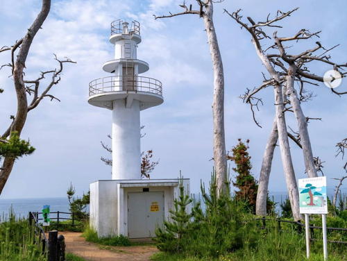
1929. Active; focal plane 24 m (79 ft); white or red light, depending on direction, occulting three times every 13 s. 17 m (56 ft) 2-stage elliptical tower with three galleries, mounted on a square 1-story concrete equipment room. Entire lighthouse is white. The Coast Guard has the photo at the top of this page, FOAL has a good page with many photos, Lighthouses of Japan also has a photo, a 2021 closeup is available, and Google has a satellite view, a sea view, and a closeup street view. There was heavy tsunami damage in this area but the lighthouse survived. Located on a promontory at the south entrance to Kesennuma Wan, about 12 km (7.5 mi) south of the city. Parking is available nearby. Site open, tower closed. . ARLHS JPN-188; JCG-1706; Admiralty M6564; NGA 4276.

Minamisanriku Town Lighthouses
Utatsu (Utatu) Saki
1924. Active; focal plane 51 m (167 ft); white flash every 3 s. 11 m (36 ft) semielliptical concrete tower with gallery, rising from a 1-story concrete equipment room. Entire lighthouse is white. Lighthouse in Japan has a page with photos, FOAL has photos (near the bottom of the page), Misty's Tour also has photos, and Google has a satellite view. Located on a promontory about 4 km (2.5 mi) southeast of Utatsu. The lighthouse is well back from the point of the cape and the entrance is not marked. Site open, tower closed. . ARLHS JPN-732; JCG-1712; Admiralty M6560; NGA 4284.
* Terahama
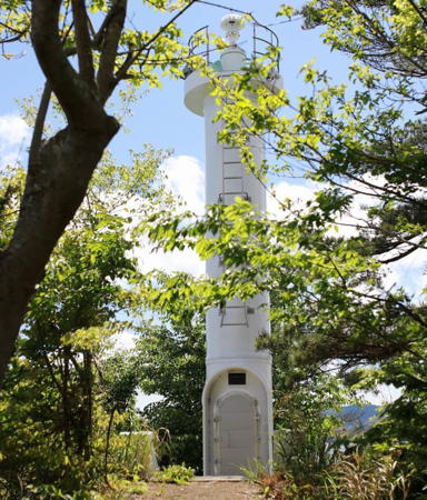
1951. Active; focal plane 49 m (161 ft); white light, 3 s on, 3 s off. 10 m (33 ft) square concrete tower with gallery, rising from an octagonal 1-story concrete equipment room. Entire lighthouse is white. A photo is at right, Lighthouse in Japan has a page with good photos, FOAL's page also has good photos, a 2018 closeup is available, and Google has a satellite view. Misty's Tour also has a photo and reports that the lighthouse stands in a large campground, the Kamiwarisaki Camping Ground. Parking is available. Located on a promontory about 15 km (9 mi) southeast of Shizugama. Site open, tower closed. . ARLHS JPN-640; JCG-1714; Admiralty M6558; NGA 4292.

Terahama Light, Minamisanriku, October 2018
Google Maps photo by 鉄仮面DR30
 

Ishinomaki City: Ogatsu Area Lighthouses
Ishinomaki is a fishing port with a pre-earthquake population of about 165,000. Thousands were killed when the city was largely inundated by the March 2011 tsunami. Some areas of the city were flooded permanently, since the earthquake dropped the elevation of the coast by more than a meter. Post-earthquake the population is a little less than 150,000.
* Ōsu (Oshu) Saki
1949. Active; focal plane 50 m (164 ft); white light, 2 s on, 2 s off. 12 m (39 ft) square cylindrical concrete tower with lantern and gallery, centered on a square 1-story equipment room. Entire lighthouse is white. A photo is at right, Hiroyuki Gotō has a 2017 photo, a 2021 closeup is available, Lighthouse-Japan.com has a page with good photos, FOAL has an excellent page for the lighthouse, Misty's Tour has additional photos, and Google has a satellite view. Located on a promontory about 25 km (15 mi) northeast of Ishinomaki. Accessible by road and a short walk (160 m), but the lighthouse is not as easy to find as one might expect. Only a small sign marks the walkway to the lighthouse and parking is limited. Site open, tower closed. . ARLHS JPN-466; JCG-1716; Admiralty M6556; NGA 4300.
* Shirogane Saki
1957. Active; focal plane 38 m (125 ft); three white flashes every 13 s. 10 m (33 ft) round concrete tower with three galleries, mounted on a square 1-story concrete equipment room. Entire lighthouse is white. Lighthouse-Japan.com has a page with photos, FOAL has a good page for the lighthouse, Misty's Tour also has photos, the Ishinomaki tourism office has a street view, and Google has an indistinct satellite view. Located on a promontory about 4 km (2.5 mi) south of Oshu Saki, part of the same cape structure. Accessible by road and a 15 minute hike; the entrance is marked by a small sign but parking is limited. Site open, tower closed. . ARLHS JPN-582; JCG-1717; Admiralty M6554; NGA 4304.
Aka Saki
1957. Active; focal plane 34 m (112 ft); white flash every 3 s. 10 m (33 ft) round concrete tower with gallery, rising from a square 1-story equipment room. Entire lighthouse is white. FOAL's page has views from the sea , Lighthouse Visits has a page for the lighthouse, and Google has a sea view and a satellite view. Located on a bluff on the west side of the entrance to the bay leading to the town of Ogatsu. May be accessible only by boat; the FOAL webmaster did not visit the lighthouse. Site status unknown. ARLHS JPN-009; JCG-1720; Admiralty M6555; NGA 4316.

Onagawa Town Lighthouses
Shikono Saki (Sikono, Yogono)
1926. Active; focal plane 58 m (190 ft); white light, 3 s on, 3 s off. 10 m (33 ft) round flared concrete tower with gallery attached to a 1-story concrete fog signal building. Entire lighthouse is white. Fog siren (one blast every 25 s). A closeup photo is available, Takeshi Yamada has a 2021 photo, Lighthouse Visits has a view from the sea, and Google has a satellite view. Located at the southern tip of an island about 6.5 km (4 mi) south of the Shirogane Saki Light. Site status unknown. ARLHS JPN-558; JCG-1721; Admiralty M6549; NGA 4320.

Ōsu Saki Light, Ishinomaki, June 2022
Instagram photo by moc_kashi72
#Megawa (Onogawa) Kō North Breakwater (1)
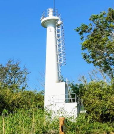
1967. Destroyed by the 2011 tsunami. This was a 10 m (33 ft) round hourglass-shaped concrete tower. Entire lighthouse was red. A 2009 photo is available. This lighthouse and the breakwater it stood on were completely destroyed by the tsunami. Late in 2011 the Admiralty reported it had been replaced by a lightbuoy and in March 2018 a new light was announced; it is a 9 m (30 ft) red post with a small equipment cabinet; focal plane 10 m (33 ft); two red flashes every 6 s. FOAL's page for Megawa has a photo and Google has a satellite view. Located at the end of the north breakwater of Megawa (Onogawa), about 15 km (9 mi) east of Ishinomaki. ARLHS JPN-1160; ex-NGA 4328. Current light: JCG-1725; Admiralty M6550.
#Megawa (Onogawa) Kō South Breakwater (1)
1967. Destroyed by the 2011 tsunami. This was a 10 m (33 ft) round hourglass-shaped concrete tower. Entire lighthouse was white. This lighthouse and the breakwater it stood on were completely destroyed by the tsunami. Late in 2011 the Admiralty reported it had been replaced by a lightbuoy and in March 2018 a new light was announced; it is a 9 m (30 ft) white post with a small equipment cabinet; focal plane 10 m (33 ft); two green flashes every 6 s. FOAL's page for Megawa has a photo and Google has a satellite view. Located at the end of the south breakwater of Megawa (Onogawa), about 15 km (9 mi) east of Ishinomaki. ARLHS JPN-1161; ex-NGA 4332. Current light: JCG-1724; Admiralty M6551.
Onogawa Wan
1969. Active; focal plane 14 m (46 ft); green flash every 3 s. 11 m (36 ft) round cylindrical concrete tower. Entire lighthouse is white. Google has a satellite view and a distant street view. This harbor serves the Onogawa Nuclear Power Plant; unlike the Fukushima plant it shut down safely following the earthquake and was not damaged by the tsunami. One of the reactor units is scheduled to be restarted in 2024. Located at the end of the east breakwater of the power plant, about 4 km (2.5 mi) southeast of Megawa. JCG-1723.5; Admiralty M6549.8; NGA 4334.

Ishinomaki City: Kinkasan Area Lighthouses
Haya Saki
1953. Active; focal plane 95 m (312 ft); white flash every 4 s; also a continuous white spotlight (JCG-1723) illuminates a reef 1.3 km (0.8 mi) to the north. 13 m (43 ft) round cylindrical concrete tower with a square concrete lantern room, rising from a 1-story concrete equipment room. The light is displayed atop the tower, and the spotlight is shown through a square window. Entire lighthouse is white. Lighthouse-Japan.com has a page with good photos, FOAL's page has closeup photos, a 2018 closeup is available, and Google has a satellite view. Located at the end of a narrow peninsula about 20 km (13 mi) east of Ishinomaki. This lighthouse is hard to find using unmarked dirt roads; local guidance will be needed. Site open, tower closed. . ARLHS JPN-094; JCG-1722; Admiralty M6548; NGA 4340.
Rikuzen Eno (Yeno) Shima (2)
Date unknown (station established 1962). Active; focal plane 87 m (285 ft); two white flashes every 10 s. 10 m (33 ft) round cylindrical tower. Entire lighthouse is white. Google has a 2020 drone view, a closeup street view, and a satellite view. Tomio Tatsumi has a 2007 closeup photo of the 1962 lighthouse, a square cylindrical concrete tower with gallery, centered on a 1-story square concrete equipment room; it was demolished. Eno Shima is a small island in the Pacific about 5 km (3 mi) east of Haya Saki. The island has a permanent population of about 130 and is the site of the University of Tokyo's tsunami laboratory. Located at the highest point of the island. Site apparently open, tower closed. ARLHS JPN-506; JCG-1727; Admiralty M6547; NGA 4336.
* Kinkasan
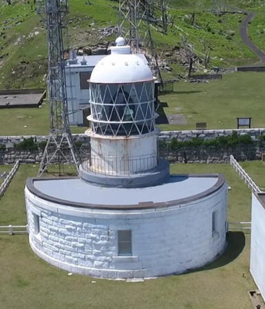
1876 (Richard Henry Brunton). Active; focal plane 55 m (181 ft); flash every 20 s, alternately red and white. 13 m (43 ft) round cylindrical stone tower with a large 1st or 2nd order lantern and gallery, rising from a semicircular 1-story stone keeper's house. A Fresnel lens, perhaps the original, is still in use. Entire lighthouse painted white. A photo is at right, Lighthouses of Japan has another photo, Lighthouse-Japan.com has a page with good photos, Shimao Takahashi has a 2021 closeup, and Google has a satellite view. This lighthouse, the oldest in the region and one of the Coast Guard's "Famous Fifty," is a rare survivor of the earliest period of Japanese lighthouse history; it is the last to be completed of the 26 western-style lighthouses designed by the Scottish engineer Richard Henry Brunton during his years (1868-1876) in Japan. Kinkasan is an island about 6.5 km (4 mi) long lying off Kuro Saki at the extreme southern end of the Rikuchū/Rikuzen Coast. The island is a popular tourist destination known for its temples and its distinctive plant life. The lighthouse is at the southeastern tip of the island, accessible by a hiking trail. Site open, tower closed. . ARLHS JPN-259; JCG-1728; Admiralty M6546; NGA 4344.
Rikuzen Kuro Saki (3?)
1991 (station established 1929). Active; focal plane 65 m (213 ft); white light, 3 s on, 3 s off. 12 m (39 ft) round cylindrical concrete tower with gallery. Entire lighthouse is white. Lighthouse-Japan.com has a page with good photos, FOAL's page also has good photos, a 2018 closeup photo is available, Misty's Tour has a photo, and Google has a satellite view. We need better information on the history of this station. NGA formerly described a skeletal tower here and Lighthouse of Japan claims the station was established in 1892. Located on Kuro Saki, the south-pointing promontory that is the end of the Rikuzen Coast, about 40 km (25 mi) southeast of Ishinomaki. Accessible by back roads and a walk of about 1.2 km (3/4 mi), but the entrance to the lighthouse is completely unmarked and the trail crosses some private property. Site open, tower closed. ARLHS JPN-507; JCG-1729; Admiralty M6544; NGA 4348.

Kinkasan Light, Ishinomaki, May 2017
Google Maps drone view
 

Ishinomaki City: Ishinomaki Bay Lighthouses
* Dōmiki Saki (Aji Shima)
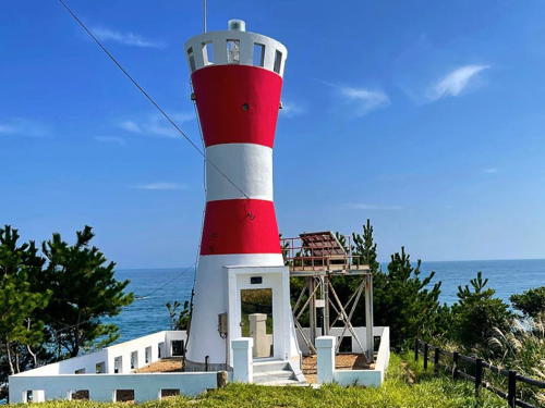
1966. Active; focal plane 31 m (102 ft); white light, 4 s on, 4 s off; also a continuous white spotlight (JCG-1732) illuminates a reef 500 m (0.3 mi) to the east. 10 m (33 ft) round hourglass-shaped concrete tower with gallery, painted with red and white horizontal bands. A photo is at right, FOAL has views from the sea, the Ishinomaki Tourism Association has a nice street view, and Google has a satellite view. Located at the southeastern tip of an island, about 4 km (2.5 mi) southwest of Kuro Saki. The island is accessible by ferry. Site open, tower closed. . ARLHS JPN-055; JCG-1731; Admiralty M6545; NGA 4352.
#Ayukawa (Aikawa) Kō (1)
Date unknown. Destroyed by the tsunami. This was a 9.5 m (31 ft) concrete post attached to a square 1-story concrete equipment shelter. Entire lighthouse was red. A May 2013 street view shows extensive damage to the harbor. Late in 2011 the Admiralty reported the light had been replaced by a lightbuoy. In November 2016 a new, smaller light was placed on the breakwater (focal plane 6 m (20 ft); red flash every 3 s. Lighthouse Visits has photos, FOAL has photos and Google has a satellite view. Site open, tower closed. ARLHS JPN-1144; ex-NGA 4356. Current light: JCG-1730; Admiralty M6542; NGA 4349.
Nigishiro Saki (Tashiro Shima)
1955. Active; focal plane 48 m (157 ft); two white flashes every 7 s. 10 m (33 ft) concrete post, rising from a square 1-story concrete equipment room. Entire lighthouse is white. Tomio Tatsumi has a closeup photo and Google has a satellite view. Located at the northern point of Tashiro Shima, an island about 15 km (9 mi) southeast of Ishinomaki. Accessible only by boat. Site status unknown. ARLHS JPN-410; JCG-1734; Admiralty M6540; NGA 4368.

Dōmiki Saki Light, Ishinomaki, July 2016
Instgram photo by toddegree
Oginohama (Kitsuneana Saki) (2)
1951 (station established 1892). Active; focal plane 37 m (121 ft); white flash every 3 s. 10 m (33 ft) concrete post attached to a square 1-story concrete equipment shelter. Entire lighthouse painted white, although the paint had peeled off in the linked 2009 photo. Lighthouse Visits has a page for the lighthouse, FOAL's page has good photos, a 2022 photo and a closeup 2020 street view are available, and Google has a satellite view. Located on a promontory sheltering the harbor of Oginohama. Accessible by a hiking trail from the western end of the port. Site open, tower closed. . ARLHS JPN-1159; JCG-1735; Admiralty M6538; NGA 4372.

Ishinomaki City: Ishinomaki Harbor Lighthouses
Ishinomaki is a city of about 140,000 residents. A traditional fishing center, it was devastated by the tsunami in 2011. More than 3000 people wrre killed, over 2500 were never found, and 29,000 lost their homes.

* Watanoha Ō Saki (2 or 3)
Date unknown (station established 1950). Active; focal plane 36 m (118 ft); white flash every 5 s. 12 m (39 ft) round cylindrical concrete tower rising from a square 1-story concrete equipment shelter. Entire lighthouse is white. A 2019 photo is available and Google has a sea view and a satellite view. Previously the light was on a slender 12 m (39 ft) concrete post attached to the equipment shelter. The name of this light is misspelled Watanoaha in many light lists. The lighthouse was "renovated" in 1972, but we don't know if it was replaced. Located on the tip of a forested peninsula at the east end of Ishinomaki harbor. Accessible by a narrow road and a short hike; the entrance is conspicuous. Site open, tower closed. ARLHS JPN-1169; JCG-1737; Admiralty M6534; NGA 4380.
* Watanoha Kō West Breakwater
1964. Active; focal plane 10 m (33 ft); continuous green light with a more intense flash every 6 s. 8 m (26 ft) concrete post rising from a square 1-story concrete equipment room. Entire lighthouse is white. FOAL's page has photos and Google has a sea view and a satellite view. This lighthouse either survived the tsunami or it has been replaced. Watanoha is the location of the replica of the ship Date Maru or San Juan Bautista, built by Spanish shipwrights for the Daimyo of Sendai in 1613. Miraculously, the ship suffered only minor damage during the earthquake and tsunami. Located at the end of the main breakwater for Watanoha port, at the east end of the Ishinomaki port district. Accessible by walking the pier (although it's a long walk). Site open, tower closed. ARLHS JPN-1170; JCG-1739; Admiralty M6535.2; NGA 4384.
Ishinomaki Gyoko West Breakwater
1976. Active; focal plane 13 m (43 ft); red flash every 3 s. 10 m (33 ft) concrete post attached to a square 1-story concrete equipment shelter. Entire lighthouse is red. FOAL has photos (middle of the page, right) and Google has a sea view and a satellite view. This small lighthouse seems to have survived the tsunami. Located at the southeast end of a detached breakwater off the Ishinomaki waterfront. Accessible only by boat. Site open, tower closed. JCG-1745; Admiralty M6533.4; NGA 4400.
#Ishinomaki Kō West Detached Breakwater (1)
1976. Destroyed by the tsunami. This was an 11 m (36 ft) round cylindrical concrete tower with lantern and gallery. Entire lighthouse was white. No photo available. This lighthouse has been replaced by a light on a post. FOAL has photos (middle of the page, left) and Google has a sea view and satellite view. Located at the end of the west detached breakwater at Ishinomaki.Accessible only by boat. Site and tower closed. Current light: JCG-1744; Admiralty M6533.6; NGA 4404.
Ishinomaki East Breakwater
Date unknown. Active; focal plane 11 m (36 ft); red flash every 4 s. 10 m (33 ft) concrete post attached to a square 1-story concrete equipment shelter. Entire lighthouse is red. FOAL's page for the two breakwater lights has photos and Google has a sea view and a satellite view. These lights stand on old jetties at the mouth of the Kitakami River, just west of the modern port facilities. Accessible only by boat. Site open, tower closed. ARLHS JPN-1148; JCG-1746; Admiralty M6532; NGA 4412.
Ishinomaki West Breakwater
Date unknown. Active; focal plane 12 m (39 ft); green light, 2 s on, 2 s off. 10 m (33 ft) concrete post attached to a square 1-story concrete equipment shelter. Entire lighthouse is white. FOAL's page for the two breakwater lights has photos and Google has a sea view and a satellite view. These lights stand on old jetties at the mouth of the Kitakami River, just west of the modern port facilities. Accessible only by boat. Site open, tower closed. ARLHS JPN-1149; JCG-1747; Admiralty M6533; NGA 4408.
Ishinomaki Hibarino Breakwater (2)
2017 (station establishment date unknown). Active; focal plane 13 m (43 ft); two red flashes every 6 s. 10 m (33 ft) round concrete tower with a flared top attached to a small equipment cabinet. Entire lighthouse is red. FOAL's page has a 2019 photo and Google has a sea view. Google's satellite view shows the previous light, a cylindrical tower. Located on a detached breakwater at the entrance to Ishinomaki's west harbor. Accessible only by boat. Site open, tower closed. JCG-1747.8; Admiralty M6531; NGA 4424.
Ha Shima Light
Ha Shima Light, Shiogama
Japanese Coast Guard Miyagi Office photo

Shiogama City Lighthouses
Ha Shima
Date unknown. Active; focal plane 36 m (118 ft); white flash every 3 s.12m (39 ft) round cylindrical concrete tower with lantern and gallery. Entire lighthouse is white. The Coast Guard has the closeup photo seen above right, FOAL's page has views from the sea, and Google has a satellite view. Located atop a small island at the southwestern end of Ishinomaki Wan (bay), about 13 km (8 mi) southwest of Ishinomaki. Accessible only by boat. Site and tower closed. ARLHS JPN-075; JCG-1753; Admiralty M6520; NGA 4432.
Zizū (Jizo) Shima (2)
Date unknown. Active; focal plane 21m (69 ft); white flash every 4 s. 11 m (36 ft) round cylindrical concrete tower. Entire lighthouse is white. A drone view is available and Google has a sea view and a satellite view. This light replaced an octagonal stone tower with gallery, painted white. Located on a small island on the south side of the approach to Shiogama, about 5 km (3 mi) northeast of the city. Accessible only by boat. Site status unknown. ARLHS JPN-1150; JCG-1756; Admiralty M6522; NGA 4444.
#Shiogama Range Front (2?)
Date unknown. Inactive since 2014 and since removed. This was a 24 m (79 ft) square pyramidal skeletal tower with gallery, painted white. Google has a 2013 street view but the tower is gone in Google's satellite view. This lighthouse was in an area flooded by the tsunami; the range was knocked out of service, but it was restored before the end of 2011. Formerly located about 200 m (220 yd) west of the inner harbor in downtown Shiogama. Site open. ex-JCG-1767; ex-Admiralty M6524; ex-NGA 4436.
#Shiogama Range Rear
Date unknown. Inactive since 2014 and since removed. This was a 21 m (69 ft) square pyramidal skeletal tower with gallery, painted white. The tower is gone in Google's satellite view. Formerly located 256 m (280 yd) west of the front light. Site open. ex-JCG-1768; ex-Admiralty M6524.1; ex-NGA 4440.
* Hanabuchi (Ho Saki)
1964. Active; focal plane 63 m (207 ft); two flashes every 20 s, two red flashes alternating with two green flashes. 23 m (75 ft) round concrete tower with lantern and gallery, rising from a 1-story concrete equipment building. Arui Kashiwagi's photo is at right, Misty's Tour has a closeup photo, Kazutaka Ashigari has a 2018 photo, FOAL's page has photos, Yōhei Katō has a nighttime street view of the lighthouse in action, and Google has a satellite view. This lighthouse was damaged by the earthquake of March 2011, but it was back in service by late 2011. Located on a promontory about 8 km (5 mi) east of Shiogama. The entrance to the light station is to the right of the entrance to the Hanabushi Shrine; parking is limited. Site open, tower closed. . ARLHS JPN-084; JCG-1759; Admiralty M6521; NGA 4452.

Hanabuchi Light, Shiogama, April 2013
Wikimedia Creative Commons photo by Arui Kashiwagi


Sendai City Lighthouses
The capital of Miyagi Prefecture, Sendai had a pre-tsunami population of about one million. The port area and coastal areas of the city were devastated by the great waves, which had heights up to 8 m (26 ft).
Sendai Kō (Shinkita South Breakwater)
Date unknown. Active; focal plane 11 m (36 ft); red light, 2 s on, 2 s off. 10 m (33 ft) concrete post attached to a square 1-story concrete equipment shelter. Entire lighthouse is red. FOAL has a photo (third row, left) and Google has a satellite view. Located on a detached breakwater on the north side of the approach to Sendai's main harbor. Accessible only by boat. Site and tower closed. JCG-1774.32; Admiralty M6521.25; NGA 4457.
Sendai North Breakwater
1972. Reactivated; focal plane 16 m (52 ft); two red flashes every 6 s. 14 m (46 ft) round cylindrical concrete tower with lantern and gallery, painted red. Hiroyuki Saitou has a photo, FOAL has photos (3/4 the way down the page, right), a view from the sea is available, and Google has a satellite view. The Sendai breakwaters and their lighthouses were heavily damaged by the tsunami in March 2011 and this lighthouse was out of service for several years. Located at the end of the north outer breakwater, marking the entrance to the harbor of Sendai. Accessible only by boat. Site and tower closed. ARLHS JPN-2638; JCG-1772; Admiralty M6521.2; NGA 4460.
Sendai South Breakwater (3)
2013 (station established 1975). Active; focal plane 15 m (49 ft); two green flashes every 6 s. 12 m (39 ft) round cylindrical concrete tower with lantern and gallery, painted white. The breakwater was extended in 1997-98, requiring a new and taller lighthouse. The Sendai breakwaters and their lighthouses were heavily damaged by the tsunami in March 2011; the lighthouse was torn from its foundations and left standing with a severe lean. In July 2013 a new light was installed; it is a copy of the 1998 light except that it is 3 m (10 ft) shorter. A photo is at right, FOAL has a photo (third row, right), a view from the sea is available, and Google has a satellite view. The crescent on the lantern dome is the device that the founder of Sendai, Date Masamune (1567-1636), wore on his helmet. Located at the end of the south outer breakwater, marking the entrance to the harbor of Sendai. Previously accessible by walking the pier. Site open, tower closed. ARLHS JPN-2639; JCG-1774; Admiralty M6521.1; NGA 4464.
Sendai Outer Breakwater East End
2001. Active; focal plane 16 m (52 ft); green flash every 4 s. 13 m (43 ft) round cylindrical concrete tower. Entire lighthouse is white. FOAL has photos (fourth row), a view from the sea is available, and Google has a satellite view. Because of its location 5 km (3 mi) offshore, this lighthouse was not destroyed by the tsunami. Located at the end of the detached breakwater protecting Sendai harbor. Accessible only by boat. Site and tower closed. JCG-1774.4; Admiralty M6521.05; NGA 4457.5.

Sendai South Breakwater Light, Sendai, July 2013
Japanese Coast Guard Miyagi Office photo

Natori City Lighthouse
Yuriage Kō
Date unknown. Active; focal plane 9 m (30 ft); white light, 3 s on, 3 s off. 7.5 m (25 ft) concrete post attached to a square 1-story concrete equipment shelter. Entire lighthouse is white. Google has a satellite view and a very distant street view. Located on the main breakwater of Yuriage harbor, at the mouth of the Natori River. May be accessible by walking the pier. Site status unknown. JCG-1779; Admiralty M6518; NGA 4472.

Information available on lost lighthouses:

Notable faux lighthouses:

Adjoining pages: North: Iwate | South: Fukushima

Return to the Lighthouse Directory index | Ratings key

Posted August 15, 2006. Checked and revised June 15, 2023. Lighthouses: 44. Site copyright 2023 Russ Rowlett and the University of North Carolina at Chapel Hill.