Lighthouses of Japan: Fukushima

The nation of Japan, known in Japanese as Nihon or Nippon (日本), occupies an archipelago off the east coast of Asia. The four main islands are Hokkaidō in the north, Honshū (the largest) in the center, Shikoku in the south, and Kyūshū in the southwest. The country includes thousands of other islands of all sizes; among them the Ryūkyū (Nansei) Islands are a long chain extending to the southwest and including the large island of Okinawa, and the Nanpō Islands are another long chain extending south into the Pacific Ocean. Much of Japan is mountainous but the coastal regions are densely populated and urbanized; the country's population is about 126 million.

Japan is divided into 47 prefectures. This page describes lighthouses of Fukushima Prefecture on the east coast of Honshū. Facing the Pacific Ocean, the coast of Fukushima is relatively low by Japanese standards. Onahama, the harbor district of Iwaki City, is the major port.

This coast was devastated by the great Tōhoku earthquake and tsunami of 11 March 2011. The major lighthouses are high enough above the sea to escape the tsunami; all were damaged by the earthquake to some extent but they have been returned to service. Many harbor lights, however, were overturned or destroyed by the tsunami. In addition to the direct damage from the tsunami Fukushima also suffered the disastrous failure of its nuclear power plant; as a result a part of the prefecture has been closed to the public since the disaster. Along the coast the exclusion zone includes most of the coastline of Futaba, all of the coastline of Okuma, and the northern coastline of Tomioka.

In Japanese the word for a lighthouse is tōdai or toudai (灯台). The words saki and misaki are for capes and headlands, hana ("nose") is a promontory, hantō is a peninsula, shima (also spelled sima or jima) is an island, bae is a reef, iwa or shi is a rocky reef, amase or se is a shoal, wan is a bay, nada is a sound or basin, kaikyō is a strait, kawa is a river, and or minato is a harbor.

Lighthouses in Japan are operated and maintained by the Japanese Coast Guard's Maritime Safety Agency. On Honshū there is usually one Coast Guard Section Office in each prefecture. That is the case in this region, with one section office at Fukushima City.

ARLHS numbers are from the ARLHS World List of Lights. JCG numbers are the Japanese Coast Guard's light list numbers. Admiralty numbers are from volume M of the Admiralty List of Lights & Fog Signals. U.S. NGA List numbers are from Publication 112.

General Sources
Lighthouses in Japan - Fukushima
A site providing photos and data for most major Japanese lighthouses.
Lighthouse-Japan.com - Fukushima
Another comprehensive site with photos and notes from visits to many lighthouses.
Form of a Lighthouse - Fukushima Prefecture
This site has photos from recent visits with notes about access; it is cited below as FOAL (Form of a Lighthouse).
Misty's Japanese Lighthouse Tour - Fukushima
Photos and notes for lighthouses in all parts of the country.
Lighthouse Visits
This site has photos for many lighthouses in this area.
Lighthouses in Fukushima Prefecture
Photos by various photographers available from Wikimedia.
About the Fukushima Maritime Safety Agency
This page on the Coast Guard Office's web site has small photos and historical information for three of the major lighthouses.
Online List of Lights - Japan
Photos by various photographers posted by Alexander Trabas.
Navionics Charts
Navigation chart for Fukushima.

Shioya Saki Light
Shioya Saki Light, Iwaki
Japanese Coast Guard Second Region photo

Northern Fukushima Lighthouses

Shinchi Town Lighthouses
Sōma Kō Northeast Breakwater
Date unknown. Active; focal plane 16 m (52 ft); two green flashes every 6 s. 12 m (39 ft) round cylindrical white concrete tower. FOAL has a photo (second row, right) and Google has a satellite view. Sōma's outer breakwater was heavily damaged by the tsunami, but this light survived. Located at the north end of the detached northeast breakwater, marking the entrance to the harbor of Sōma. Accessible only by boat. Site and tower closed. ARLHS JPN-1166; JCG-1782.85; Admiralty M6517.47; NGA 4478.
Sōma Kō North Breakwater
Date unknown. Active; focal plane 11 m (36 ft); two red flashes every 6 s. Approx. 8.5 m (28 ft) concrete post attached to a square 1-story concrete equipment building. Entire lighthouse is red. FOAL has a photo (second row, left) and Google has a satellite view. Located at the end of the breakwater at the north end of Sōma harbor. Site status unknown. JCG-1782.9; Admiralty M6517.46; NGA 4479.
#Sōma Kō South Breakwater
Date unknown. Inactive since 2018 and apparently removed. This was an 11 m (36 ft) round cylindrical white concrete tower with a flared top. Google has a satellite view of the location. Replaced by a light on a new detached breakwater (next entry). Located at the end of the original south breakwater of Sōma harbor. Site status unknown. ARLHS JPN-593; ex-JCG-1784; ex-Admiralty M6517.4; NGA 4480.
Sōma Kō Detached (East) Breakwater
2018. Active; focal plane 14 m (46 ft); red flash every 3 s. Approx. 11 m (36 ft) post attached to a square 1-story equipment shelter. Entire lighthouse is red. FOAL has a photo (fourth row, right) and Google has a satellite view. Located at the south end of the detached breakwater. Accessible only by boat. Site open, tower closed. JCG-1784; Admiralty M6517.45; NGA 4484.
Sōma Kō Matsukawa South Breakwater
Date unknown. Active; focal plane 15 m (49 ft); green flash every 4 s. Approx. 11 m (36 ft) concrete post rising from a square 1-story concrete equipment building. Entire lighthouse is white. FOAL has photos (third and fourth rows, left) and Google has a sea view and a satellite view. Located at the end of the main breakwater for the Matsukawa harbor, just southeast of Sōma harbor. Site status unknown. ARLHS JPN-1353; JCG-1785; Admiralty M6517; NGA 4488.
* Uno O Saki (Unoosaki)
1953. Active; focal plane 40 m (131 ft); white flash every 10 s. 13 m (43 ft) rectangular cylindrical concrete tower with lantern and gallery. Entire lighthouse is white. A closeup photo is at right, Lighthouse-Japan.com has a page with good photos, FOAL's page has several photos, Safman Mats has a 2018 photo, a 2021 photo is available, Misty's Tour also has a photo, and Google has a sea view, a 2019 street view (also seen at right) and a satellite view. This lighthouse was damaged by the 2011 earthquake, but was back in service later in the year. Located on a cape at the south end of the harbor of Sōma. Accessible by a short hile from the harbor area; parking is available. Site open, tower closed. . ARLHS JPN-717; JCG-1787; Admiralty M6516; NGA 4496.

Uno O Saki Light, Sōma, April 2019
Google Maps street view

Minamisōma City Lighthouse
Tohokundenryoku (Leading)
Date unknown. Active; focal plane 11 m (36 ft); white, red or green light depending on direction, occulting once every 8 s. 7 m (23 ft) round white concrete tower. Google has a satellite view. Located on the north breakwater of the Haramachi Thermal Power Station in Minamisōma. Site and tower closed. JCG-1787.4; Admiralty M6516.85; NGA 4497.
Tohokundenryoku North Breakwater
Date unknown. Active; focal plane 10 m (33 ft); red flash every 5 s. 7.5 m (25 ft) round red concrete tower. A distant drone view is available and Google has a satellite view. Located at the end of the north breakwater of the Haramachi Thermal Power Station in Minamisōma. Site and tower closed. JCG-1787.43; Admiralty M6516.7; NGA 4499.
Tohokundenryoku South Breakwater
Date unknown. Active; focal plane 10 m (33 ft); green flash every 5 s. 7.5 m (25 ft) round white concrete tower. Google has a satellite view. Located at the end of the south breakwater of the Haramachi Thermal Power Station in Minamisōma. Site and tower closed. JCG-1787.45; Admiralty M6516.8; NGA 4498.

Note: The next two lighthouses are inside the Fukushima Nuclear Exclusion Zone.

Okuma Town Lighthouse
Toden Fukushima South Breakwater (Nuclear Power Station)
Date unknown. Reactivated (inactive 2011- 2017); focal plane 15 m (49 ft); green light, 3 s on, 3 s off. 11 m (36 ft) round white concrete tower attached to a square 1-story equipment shelter. No photo available but Google has a post-tsunami satellite view. This light guided vessels arriving at the Fukushima Daiichi Nuclear Plant, site of multiple nuclear disasters following the March 2011 tsunami. Following the disaster an area around the plant 20 km (13 mi) in radius was evacuated. The light was reactivated in April 2017. Located at the end of the nuclear plant's south breakwater. Site and tower closed. ARLHS JPN-1365; JCG-1788; Admiralty M6515.4; NGA 4500.

Tomioka Town Lighthouse
Oragahama (2)
1997 (station established 1955). Active; focal plane 41 m (134 ft); white flash every 8 s. 12 m (39 ft) round cylindrical concrete tower with lantern and gallery. Entire lighthouse is white. A 2020 photo is at right, Lighthouse of Japan has a page with excellent photos taken in March 2010, Misty's Tour also has a photo, a 2017 view from the sea is available, Lighthouses of Japan also has a photo of the original lighthouse (at the bottom of the page), and Google has a satellite view. This lighthouse was out of service following the earthquake, but it was placed back in service in April 2013. Located on a bluff projecting into the sea about 5 km (3 mi) northeast of Tomioka and 7 km (4 mi) south of the Fukushima nuclear plant; this is well within the nuclear disaster exclusion zone. Site and tower closed. ARLHS JPN-492; JCG-1789; Admiralty M6515; NGA 4504.

Hirono Town Lighthouse
Toden Hirono South Breakwater
Date unknown. Active; focal plane 17 m (56 ft); green light, 3 s on, 3 s off. 13 m (43 ft) concrete post attached to a square 1-story concrete equipment shelter. Entire lighthouse is white. Google has a satellite view. This light guides vessels arriving at the Hirono Power Plant, a fossil-fuel (non-nuclear) facility. This location is just outside the Fukushima nuclear exclusion zone. It was evacuated initially but the power plant was restored to operation in July 2011 and the town of Hirono reopened in April 2012. (Two years later only about a quarter of the previous population had returned.) Located at the end of the power plant's south breakwater. Site and tower closed. ARLHS JPN-1364; JCG-1791; Admiralty M6514.95; NGA 4520.
 

Oragahama Light, Tomioka, November 2020
Instagram photo copyright murasakioribe96rk
 

Iwaki City Lighthouses

The city of Iwaki is a large metropolitan area formed in 1966 by merging fourteen former municipalities. One of Japan's largest cities by area, it covers most of southeastern Fukushima Prefecture.

Northern Iwaki Lighthouses
* Hisanohama Kō North Breakwater
1974. Active; focal plane 15 m (49 ft); red light, 4 s on, 4 s off. 10 m (33 ft) concrete post attached to a square 1-story concrete equipment shelter. Entire lighthouse is red. Satoshi Tsukahara's 2023 photo is at right, FOAL's page has photos, and Google has a satellite view and a distant street view. This light was listed as temporarily extinguished after the earthquake, but it was later restored; there was no mention by the Admiralty of damage to the other Hisanohama harbor lights. Located on the north breakwater of Hisanohama. Accessible by walking the pier. Site open, tower closed. ARLHS JPN-1348; JCG-1794; Admiralty M6514.6; NGA 4524.
* Hisanohama Kō South Breakwater
1974. Active; focal plane 15 m (49 ft); continuous green light with a more intense flash every 5 s. 11 m (36 ft) concrete post attached to a square 1-story concrete equipment shelter. Entire lighthouse is white. FOAL's page has photos, and Google has a satellite view and a street view across the harbor. Located on the south breakwater of Hisanohama. Accessible by walking the pier. Site open, tower closed. ARLHS JPN-1350; JCG-1796; Admiralty M6514.9; NGA 4528.
Hisanohama Kō East Breakwater
Date unknown. Active; focal plane 12 m (39 ft); two red flashes every 6 s. 7 m (23 ft) round conical concrete tower. Entire lighthouse is red. A Coast Guard photo is at right, FOAL's page has a closeup photo (third row), and Google has a satellite view. Strangely, NGA lists this as the west breakwater, an obvious error. Located on the south end of the detached outer breakwater of Hisanohama. Accessible only by boat. Site open, tower closed. ARLHS JPN-1351; JCG-1795; Admiralty M6514.8; NGA 4532.

Hisanohama North Breakwater Light, Iwaki, May 2023
Google Maps photo by Satoshi Tsukahara
Yotsukura Kō (Detached Breakwater)
Date unknown. Active; focal plane 13 m (43 ft); two red flashes every 6 s. 9 m (30 ft) round concrete tower with a flared top. Entire lighthouse is red. Google has a satellite view and a distant street view across the harbor. Located at the south end of a short detached breakwater off the fishing port of Yotsukura. Accessible only by boat. Site open, tower closed. ARLHS JPN-1373; JCG-1796.8; Admiralty M6514.3; NGA 4542.
Yotsukura Kō South Detached Breakwater
Date unknown. Active; focal plane 10 m (33 ft); two green flashes every 6 s. 7.5 m (25 ft)concrete post attached to a square 1-story concrete equipment shelter. Entire lighthouse is white. Google has a satellite view and a distant street view across the harbor. Located at the north end of the main detached breakwater off the fishing port of Yotsukura. Accessible only by boat. Site open, tower closed. ARLHS JPN-1371; JCG-1797; Admiralty M6514.2; NGA 4536.
Toyama Kō Detached Breakwater
1988. Active; focal plane 12 m (39 ft); three green flashes every 12 s. 9 m (30 ft) round concrete tower with a flared top, attached to a small equipment shelter. Entire lighthouse is white. FOAL's page has several photos and Google has a satellite view. The Admiralty lists the light as "Shioya Saki Northward." Located at the end of a breakwater sheltering the north harbor of Toyama, about 1.6 km (1 mi) north of the Shioya Saki lighthouse. Accessible only by boat. Site status unknown. ARLHS JPN-1368; JCG-1800.7; Admiralty M6513; NGA 4550.
**** Shioya Saki (2)
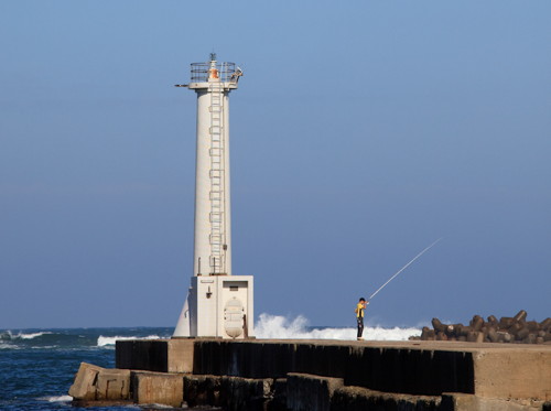
1940 (station established 1899). Active; focal plane 73 m (240 ft); white flash every 15 s. 27 m (89 ft) round concrete tower with lantern and gallery. A large Fresnel lens is in use. Entire lighthouse is white. A Coast Guard photo is at the top of this page, Lighthouses of Japan has additional photos, FOAL's page also has photos, Aoi Shinonome has a 2021 photo, a 2009 photo is available, Masashiro Hayata has a closeup of the lantern, Aquiloni Pano has a street view, and Google has a satellite view. This is a staffed light and communications station with a visitor center and lighthouse museum (seen in a 2021 photo). The original lighthouse, built of brick, was destroyed by an earthquake in 1938. The second lighthouse was heavily damaged by an American air raid only five days before the end of World War II. It was repaired and returned to service in 1947. The lighthouse was also damaged by the 2011 earthquake; it was out of service until November 2011. The museum was damaged badly by the earthquake and did not reopen until February 2014. The light station may also be endangered by erosion of the cliff on which it stands. Located atop a spectacular promontory about 10 km (6 mi) southeast of Iwaki. Site open, tower open daily to guided tours. . ARLHS JPN-574; JCG-1801; Admiralty M6512; NGA 4552.

Eastern Iwaki Lighthouses
Toyama Kō Shioya Saki Outer Breakwater
Date unknown. Active; focal plane 14 m (46 ft); two green flashes every 6 s. 9.5 m (31 ft) concrete post attached to a square 1-story concrete equipment shelter. Entire lighthouse is white. FOAL has a photo (bottom of the page) and Google has a satellite view and a distant street view across the harbor. Located at the east end of a detached outer breakwater protecting the harbor in the lee of Shioya Saki. Accessible only by boat. Site status unknown. ARLHS JPN-1369; JCG-1801.5; Admiralty M6511; NGA 4556.
Ena Kō Southeast (Offing) Breakwater
Date unknown. Active; focal plane 15 m (49 ft); red flash every 3 s. 11 m (36 ft) round concrete tower with a flared top. Entire lighthouse is red. Google has a satellite view and a very distant street view across the harbor. Located on a short detached breakwater protecting the entrance to Ena harbor. Accessible only by boat. Site status unknown. JCG-1803; Admiralty M6509.6; NGA 4564.
#Ena Kō Outer Breakwater (1)
Date unknown. Replaced in 2019. This was an 11 m (36 ft) round concrete tower with a flared top. Entire lighthouse was white. Google has aa satellite view. Both FOAL and Lighthouse Visits mention the replacement but no photo of the new light is available. Located at the east end of detached outer breakwater. Accessible only by boat. Site status unknown. Active light: JCG-1802; Admiralty M6509.5.
#Ena Kō West Breakwater (?)
Date unknown. Inactive since 2017 and removed sometime in 2019-20. 13 m (43 ft) concrete post attached to a square 1-story concrete equipment shelter. Entire lighthouse is white. A 2009 photo is at right and Google has a 2013 street view. Google's satellite view confirms the removal of the lighthouse. This was an unusually robust example of this style of pierhead light. FOAL has an April 2019 photo (second row, right) of the tower with the lamp removed. Located at the east end of the inner breakwater protecting Ena harbor, about 8 km (5 mi) east of Onahama. Accessible by walking the pier. Site open, tower closed. ex-JCG-1804; ex-Admiralty M6508; NGA 4560.
Ena West Breakwater Light
Ena Kō West Breakwater Light (now lost), Iwaki, September 2009
ex-Panoramio photo copyright urapyon; used by permission
#Nakanosaku Kō Old East Breakwater
Date unknown (station established 1935). Destroyed by the 2011 tsunami. 7.5 m (25 ft) concrete post attached to a square 1-story concrete equipment shelter. Entire lighthouse was red. The east breakwater light is missing in Google's satellite view. Although it is still listed by NGA as of 2022 this lighthouse will not be replaced; in April 2016 it was listed as haishi (obsolete). Located on the east breakwater of the old inner harbor of Nakanosaku. ARLHS JPN-399; ex-JCG-1808; ex-Admiralty M6507.4; NGA 4580.
#Nakanosaku Kō Old West Breakwater (2?) (?)
2011 (station established 1959). Replaced. This was a 9 m (30 ft) concrete post attached to a square 1-story concrete equipment shelter. Entire lighthouse was white. FOAL's page has 2015 photos and Google has a 2019 street view. However Google's satellite view shows the post light (focal plane 9 m (30 ft); green flash every 3 s) that replaced the lighthouse in November 2019. This light was damaged by the tsunami but was returned to service later in 2011. Located on the west breakwater of the old inner harbor of Nakanosaku. ARLHS JPN-1354; JCG-1809; Admiralty M6507; NGA 4584.
Nakanosaku Kō East (Detached) Breakwater
Date unknown. Active; focal plane 14 m (46 ft); two red flashes every 8 s. 10 m (33 ft) concrete post attached to a square 1-story concrete equipment shelter. Entire lighthouse is red. FOAL's page has a photo (bottom of the page) and Google has a long-range street view and a satellite view. Located on a detached breakwater on the east side of the modern entrance to Nakanosaku harbor. Accessible only by boat. ARLHS JPN-1355; JCG-1812; Admiralty M6505.6; NGA 4588.
#Nakanosaku Kō West Breakwater (2)
2013. Removed. This was a 10 m (33 ft) concrete post attached to a square 1-story concrete equipment shelter. Entire lighthouse is white. FOAL's page has a photo (bottom of the page) and Google has a 2011 street view but its satellite view confirms the removal of the light. The original light was destroyed by the 2011 tsunami. Located on the short breakwater on the west side of the modern entrance to Nakanosaku harbor. Accessible by walking the pier. ARLHS JPN-1356; JCG-1813; ex-Admiralty M6505.4; NGA 4592.
Ryugasaki Hana
Date unknown. Inactive since 2016. 16 m (52 ft) lantern and gallery mounted atop a large steel tripod. Lighthouse painted white. A 2009 photo is at right, FOAL's page has 2015 photos, Misty's Tour has a photo, Mutsuki Hiroshi has a 2018 drone view, Sakae Ibuki has a 2020 view from shore, and Google has a satellite view. The lighthouse was deactivated in December 2016 but it was still standing as of 2020 and is still listed by NGA. Located in the surf just off the modern entrance to Nakanosaku harbor. Accessible only by boat but easy to view from shore. Site and tower closed. ARLHS JPN-1363; ex-JCG-1814; ex-Admiralty M6505; NGA 4604.
Ryugasaki Hana Light
Ryugasaki Hana Light, Iwaki, September 2009
photo copyright urapyon; used by permission

Onahama Port Lighthouses
* Bandokoro (2)
2014 (station established 1928). Active; focal plane 35 m (115 ft); white light, 3 s on, 3 s off. 11 m (36 ft) hexagonal white fiberglass tower; the fiberglass is molded to resemble stone. A 2018 photo is at right, a 2021 photo is available, Trabas has a photo, a collection of photos is available, and Google has a satellite view. The earlier light was a concrete post attached to a square 1-story concrete equipment room. Lighthouse-Japan.com has a page with good photos from 2007 and Misty's Tour also has a photo. This lighthouse was damaged by the earthquake. Although it was back in service later in 2011, cracks in the tower forced its replacement in August 2014. Located in a park on a promontory on the east side of Onahama harbor, about 10 km (6 mi) south of Iwaki. Parking is available near the lighthouse. Site open, tower closed. . ARLHS JPN-041; JCG-1815; Admiralty M6504; NGA 4608.
Onahama Kō East Breakwater
Date unknown. Active; focal plane 14 m (46 ft); two red flashes every 6 s. 10 m (33 ft) concrete post attached to a square 1-story concrete equipment shelter. Entire lighthouse is red. Trabas has a photo, FOAL has a photo (bottom of the page) and Google has a satellite view and a very distant street view. Located at the end of the east breakwater at Onahama. Site status unknown (may be accessible by walking the pier from Matsushita Park). ARLHS JPN-1358; JCG-1818; Admiralty M6500.4; NGA 4612.
Onahama Kō West Breakwater East Head
Date unknown. Active; focal plane 14 m (46 ft); two green flashes every 6 s. 10 m (33 ft) concrete post attached to a square 1-story concrete equipment shelter. Entire lighthouse is white. Trabas has a photo, FOAL has a photo (third row, right) and Google has a satellite view. NGA and ARLHS call this the "Misaki Breakwater" light. Located at the end of the east breakwater at Onahama. Site status unknown (may be accessible by walking the pier from Matsushita Park). ARLHS JPN-1360; JCG-1819; Admiralty M6500.6; NGA 4620.
#Onahama Kō
Date unknown. Destroyed in 2012. Approx. 13 m (43 ft) round concrete tower; lantern removed. This former lighthouse survived the tsunami but was demolished, apparently in June 2012; it has vanished from Google's satellite view. This lighthouse marked the old eastern entrance to Onahama harbor; with subsequent redevelopment there is no longer a clear passage through this area. Located at the east end of a detached breakwater at Onahama. Accessible only by boat. Site open, tower closed. ex-JCG-1816.

Bandokoro Light, Iwaki, June 2018
ex-Google Plus photo by Plasma PKMN
Onahama South Breakwater West Head
Date unknown. Active; focal plane 19 m (62 ft); two red flashes every 7 s. 16 m (52 ft) round cylindrical concrete tower with lantern and gallery. Entire lighthouse is red. A Coast Guard photo is at right, Trabas has a photo, a 2023 photo is available, FOAL has a photo (second row, left), another photo is available (3/4 of the way down the page), and Google has a satellite view. Located at the end of the new outer breakwater of Onahama. Accessible only by boat. Site and tower closed. ARLHS JPN-1361; JCG-1817.5; Admiralty M6499.8; NGA 4632.
Onahama No. 2 Southwest Breakwater (Hassaki Outer Breakwater) East Head
Date unknown. Active; focal plane 15 m (49 ft); green flash every 5 s. 12 m (39 ft) tapered square skeletal tower, painted white and mounted on a large concrete base. Trabas has a photo, FOAL has photos (fifth row on the page) and Google has a satellite view. Located at the east end of the older detached breakwater of Onahama. Accessible only by boat. Site and tower closed. ARLHS JPN-1357; JCG-1820; Admiralty M6500; NGA 4636.
Onahama No. 2 Southwest Breakwater (Hassaki Outer Breakwater) West Head
Date unknown. Active; focal plane 17 m (56 ft); red flash every 3 s. 13 m (43 ft) round cylindrical concrete tower with a flared top. Entire lighthouse is red. Trabas has a photo, FOAL has a photo (third row on the page) and Google has a satellite view. Located at the west end of the older detached breakwater of Onahama. Accessible only by boat. Site and tower closed. ARLHS JPN-1347; JCG-1822; Admiralty M6503.5; NGA 4648.
Onahama Otsurugi (Hassaki) Breakwater)
Date unknown. Active; focal plane 17 m (56 ft); three green flashes every 13 s. 13 m (43 ft) concrete post attached to a square concrete equipment shelter. Entire lighthouse is white. Junichiro Hoshikawa has a 2012 photo, Trabas has a photo, FOAL has a photo (second row, right) and Google has a satellite view. Located on a breakwater at the south end of Onahama harbor. Accessible only by boat. Site and tower closed. JCG-1823; Admiralty M6502.8; NGA 4644.

Southern Iwaki Lighthouse
Nakoso (Hirakata) Kō
Date unknown. Active; focal plane 13 m (43 ft); green flash every 5 s. 9 m (30 ft) concrete post attached to a 1-story concrete equipment shelter. Entire lighthouse is white. Trabas has a closeup photo, FOAL's page has many photos, and Google has a satellite view. The fishing port of Hirakata straddles the border between Fukushima and Ibaraki prefectures, with the portion in Fukushima being known also as Nakoso. Located at the north end of the detached breakwater of the Nakoso port. Accessible only by boat but easily seen from shore. Site open, tower closed. ARLHS JPN-1388; JCG-1825; Admiralty M6499; NGA 4652.
Onohama South Breakwater Light
Onahama South Breakwater West Head Light
Japanese Coast Guard Fukushima Office photo

Information available on lost lighthouses:

Notable faux lighthouses:

Adjoining pages: North: Miyagi | South: Ibaraki

Return to the Lighthouse Directory index | Ratings key

Posted August 15, 2006. Checked and revised June 22, 2023. Lighthouses: 37. Site copyright 2023 Russ Rowlett and the University of North Carolina at Chapel Hill.