Lighthouses of Japan: Western Yamaguchi

The nation of Japan, known in Japanese as Nihon or Nippon (日本), occupies an archipelago off the east coast of Asia. The four main islands are Hokkaidō in the north, Honshū (the largest) in the center, Shikoku in the south, and Kyūshū in the southwest. The country includes thousands of other islands of all sizes; among them the Ryūkyū (Nansei) Islands are a long chain extending to the southwest and including the large island of Okinawa, and the Nanpō Islands are another long chain extending south into the Pacific Ocean. Much of Japan is mountainous but the coastal regions are densely populated and urbanized; the country's population is about 126 million.

Japan is divided into 47 prefectures. Yamaguchi Prefecture is located at the extreme southwestern tip of the main island of Honshū. Yamaguchi has coasts facing south on the Seto Inland Sea (Seto Naikai) and west and northwest on the Sea of Japan. The narrow, twisting Kanmon Strait connects these two seas and barely separates Honshū from Kyūshū. The principal ports in Yamaguchi are Tokuyama on the Inland Sea, Shimonoseki on the Kanmon Strait, and Nagato on the Sea of Japan.

Because of its lengthy coastline, Yamaguchi Prefecture has an unusually large number of lighthouses. This page includes lighthouses of the prefecture's Sea of Japan coast; the Southern Yamaguchi and Eastern Yamaguchi pages have the lighthouses of the Kanmon Strait and Seto Inland Sea.

In Japanese the word for a lighthouse is tōdai or toudai (灯台). The words saki and misaki are for capes and headlands, hana ("nose") is a promontory, hantō is a peninsula, shima (also spelled sima or jima) is an island, bae is a reef, iwa or shi is a rocky reef, amase or se is a shoal, wan is a bay, nada is a sound or basin, kaikyō is a strait, kawa is a river, and kō or minato is a harbor.

Lighthouses in Japan are operated and maintained by the Japanese Coast Guard's Maritime Safety Agency. On Honshū there is at least one Coast Guard Section Office in each prefecture, often two or more. The situation in Yamaguchi is more complicated. The lighthouses of th prefecture's west coast are maintained by the Moji Office, located across the Kanmon Strait in Fukuoka Prefecture, while the Senzaki Office in northern Yamaguchi maintains the lights on the prefecture's northern Sea of Japan coast.

A note on the Sea of Japan/East Sea controversy: The Directory takes no side in any international dispute; it makes use of the terminology, names, and spellings as they currently exist in each area covered. The sea between Japan and Korea is called the Sea of Japan on the pages for Japan and the East Sea on the pages for Korea.

ARLHS numbers are from the ARLHS World List of Lights. JCG numbers are the Japanese Coast Guard's light list numbers. Admiralty numbers are from volume M of the Admiralty List of Lights & Fog Signals. U.S. NGA List numbers are from Publication 112.

General Sources:
Lighthouse-Japan.com - Yamaguchi
Another comprehensive site with photos and notes from visits to many lighthouses.
Lighthouse Visit
Another site with photos of Yamaguchi lighthouses.
Misty's Japanese Lighthouse Tour - Yamaguchi
Photos and a few notes for lighthouses in all parts of the country.
Senzaki Coast Guard Office - Lighthouses
Photos and data for the major lighthouses on the prefecture's northwest coast.
Moji Coast Guard Office - Lighthouses
Photos of lighthouses in the Moji Coast Guard District.
Online List of Lights - Japan - Kanmon Strait and Honshu West Coast
Photos by various photographers posted by Alexander Trabas.
Lighthouses in Yamaguchi Prefecture
Photos by various photographers available from Wikimedia.
Lighthouses in the Meiji Period
Information and photos of lighthouses built during the reign of the Emperor Meiji (1868-1912), posted by the 7th Coast Guard Region.
Japan: Modern Lighthouses
Historic postcard views posted by Michel Forand.
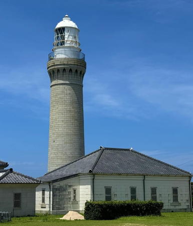

Tsuno Shima Light, Shimonoseki, August 2024
Instagram photo by todai_oshiro


Nagato Kawajiri Misaki Light, Nagato, February 2025
Google Maps photo by Yukako Guesthouse

Shimonoseki City (Moji Coast Guard District) Lighthouses

West Coast (Sea of Japan) Lighthouses
Kurumi Se (Kurumi No Se)
Date unknown. Active; focal plane 12 m (39 ft); two white flashes every 5 s. 12 m (39 ft) round hourglass-shaped concrete tower with gallery, painted black with one red horizontal band. Trabas has a closeup photo, and Bing has an indistinct satellite view of the reef. Located on a reef about 2.5 km (1.5 mi) west of Fukue. Accessible only by boat. Site open, tower closed. JCG-0701; Admiralty M5330; NGA 1540.
Futaoi (Hutaoi, Hutsaoi) Shima
1912. Active; focal plane 104 m (341 ft); three white flashes every 30 s. 15 m (49 ft) octagonal concrete tower with lantern and gallery, attached to a 1-story concrete keeper's house. Entire lighthouse is white. Yukihiro Matsumura's 2022 photo is at right, the Moji Coast Guard Office has a photo, Trabas has Jim Smith's photo, Yukihiro Matsumura has a 2022 photo, a 2015 photo is available, and Google has a satellite view. Futaoi Shima is an inhabited island about 6 km (3.5 mi) off the mainland and about 16 km (10 mi) north northwest of Daiba Hana and the entrance to the Kanmon Strait. The light here is an important guide for ships approaching the strait, especially from the north. In 1951 the lighthouse was the first in Japan to be powered by wind, but it was converted to regular electric power after lines were brought to the station in 1967. Located at the southwestern tip of the island, which is accessible by ferry. Site status unknown. . ARLHS JPN-147; JCG-0704; Admiralty M5322; NGA 1548.
Yadama (Yatama) Kō
1963. Active; focal plane 13 m (43 ft); two green flashes every 6 s. 10 m (33 ft) concrete post attached to a square 1-story concrete equipment shelter. Entire lighthouse is white. Trabas has a closeup photo, and Google has a street view and a satellite view. Located at the end of the west breakwater of Yadama harbor, about 13 km (8 mi) southeast of Tsuno Shima. Accessible by walking the pier. Site open, tower closed. ARLHS JPN-1679; JCG-0707; Admiralty M7400; NGA 1560.
* Kottoi
1912. Active; focal plane 27 m (89 ft); white or red light depending on direction, occulting once every 8 s; in addition, a continuous white spotlight (JCG-0710) illuminates a stone beacon on a nearby reef. 6 m (20 ft) octagonal concrete tower with lantern and gallery. Entire lighthouse is white. Trabas has a closeup photo, Lighthouse Visit has a page with photos, Benedict Lee has a closeup photo, the Coast Guard has a closeup, and Google has a satellite view. This is the westernmost lighthouse on the mainland of Honshū. Located on a bluff on the north side of the entrance to Kottoi, a small town about 35 km (22 mi) west of Nagato. An unmarked stairway leads from the waterfront to the lighthouse. Site open, tower closed. . ARLHS JPN-291; JCG-0709; Admiralty M7399; NGA 1564.
**** Tsuno (Tuno) Shima
1876 (Richard Henry Brunton). Active; focal plane 45 m (148 ft); white flash every 5 s. 30 m (98 ft) round stone tower with lantern and gallery. The tower is unpainted gray stone; lantern painted white. Adjoining keeper's house and other light station buildings. A 2024 photo is at the top of this page, Trabas has a fine closeup photo, another good photo is available, the Coast Guard has a photo, and Google has a street view and a satellite view of the station. This handsome lighthouse is the last of the lighthouses built in Japan by the British engineer Richard Henry Brunton. It marks the "top of the toe" of Honshū, a place where the trend of the coastline shifts from north-south to east-west. The island, Tsuno Shima, is connected to the mainland by an exceptionally scenic bridge. Located at the western tip of the island. Site open, tower open for climbing daily. . ARLHS JPN-693; JCG-0715; Admiralty M7397; NGA 1568.

Futaoi Shima Light, Shimonoseki, JUNE 2022
Instagram photo by Yukihiro Matsumura
* Kuzu Se
1972. Active; focal plane about 19 m (62 ft); continuous white spotlight. 4 m (13 ft) square stone tower, painted white. Located at the base of the Tsuno Shima lighthouse, this light illuminates a reef 1.3 km (0.8 mi) north northwest. Site open, tower closed. JCG-0716.
* Motoyama
1982. Active; focal plane 60 m (197 ft); two continuous white spotlights illuminating the two ends of the Sano Se reef north of Tsunoshima. 13 m (43 ft) square cylindrical concrete tower carrying a large square lantern room and gallery. Entire lighthouse is white. Google has a street view and a satellite view. Located near the northern point of the island Tsuno Shima. Site open (limited parking available), tower closed. JCG-0717 and 0718; NGA 1572.
Nagato Ise
Date unknown. Active; focal plane 18 m (59 ft); white flash every 3 s. 13 m (43 ft) round tapered concrete tower with gallery, mounted on a round concrete pier. Entire lighthouse is white. A 2023 photo is at right, Lighthouse Visit has a page with photos, Trabas has a photo, the Coast Guard has a closeup, and Google has a satellite view and a distant street view from the Tsuno Shima Bridge. Located on a skerry in the northern entrance to the strait separating Tsuno Shima from the mainland. Accessible only by boat. Site open, tower closed. ARLHS JPN-1642; JCG-0714; Admiralty M7396; NGA 1584.
Yuya Kō Agawa Breakwater
Date unknown. Active; focal plane 10 m (33 ft); green flash every 3 s. 8.5 m (28 ft) concrete post rising from a square 1-story concrete equipment shelter. Entire lighthouse is white. Trabas has a closeup photo, a 2021 photo is available, and Google has a street view and a satellite view. Located on a detached breakwater protecting Agawa harbor, on the south side of Yuya Bay. Accessible only by boat. Site open, tower closed. JCG-0720; Admiralty M7395.4; NGA 1576.
Yuya Kō Awano Breakwater
Date unknown. Active; focal plane 12 m (39 ft); green flash every 3 s. 10 m (33 ft) round cylindrical concrete tower. Entire lighthouse is white. Trabas has a closeup photo, S. Katsuragi has a 2020 photo, and Google has a satellite view and a distant street view. Located on a detached breakwater protecting Awano harbor, on the south side of Yuya Bay. Accessible only by boat. Site open, tower closed. JCG-0721; Admiralty M7395.6; NGA 1580.

Nagato Ise Light, Shimonoseki, March 2023
Google Maps photo by Leon

North Coast (Senzaki Coast Guard District) Lighthouses

Nagato City Lighthouses
Hon Yuya (Funa Se)
1976. Active; focal plane 95 m (312 ft); continuous white spotlight. The light illuminates the Funa Se reef about 800 m (1/2 mi) south southwest. 11 m (36 ft) concrete post with a large, square lantern room. Entire lighthouse is white. Trabas has a closeup photo, and Google has a satellite view. Erroneously listed as "Yuya Ko" in NGA. Located on the north side of Yuya Bay about 1 km (0.6 mi) east of the Tawara Shima lighthouse (next entry). Accessible by road but the light is hard to find and there's no parking. Site open, tower closed. ARLHS JPN-766; JCG-0724; Admiralty M7394.2; NGA 1596.
Yuya Kō (Tawara Shima, Yuya Wan)
Date unknown. Active; focal plane 39 m (128 ft); white light occulting twice every 10 s; also a continuous white spotlight (JCG-0719.1) illuminates a nearby reef. 10 m (33 ft) round concrete tower rising from a 1-story concrete equipment room. Entire lighthouse is white. Trabas has a photo, the Coast Guard has a page with a closeup photo (seen at right), a 2003 closeup is available, and Google has a satellite view and a distant street view. The lighthouse stands at the summit of a small island (Tawara Shima) sheltering Yuya harbor. The island is connected tenuously to the mainland by a series of stepping stones that can be crossed at low tide, but some local knowledge is probably needed to do this safely. Site open, tower closed. ARLHS JPN-1683; JCG-0719; Admiralty M7394; NGA 1600.
* Nagato Kawajiri (Kawaziri) Misaki (1?)
1929. Active; focal plane 70 m (230 ft); white light, 3 s on, 3 s off. 8.5 m (28 ft) concrete post rising from a 1-story concrete equipment room. Entire lighthouse is white. A 2025 photo is at the top of this page, the Coast Guard also has a page with a photo, a 2022 photo is available, Trabas has a distant view, and Google has a satellite view. Despite its small size, this is an important light for navigation along this dangerous coast. An Admiralty Notice to Mariners suggests this lighthouse may have been replaced in 2017; new photos are needed. Located on a sharp headland about 15 km (9 mi) west northwest of Nagato. Accessible by a very scenic hiking trail; parking is available at the trailhead. Site open, tower closed. Site manager: Kita-Nagato Kaigan Quasi-National Park. ARLHS JPN-395; JCG-0725; Admiralty M7392; NGA 1604.

Tawara Shima Light, Nagato
Japanese Coast Guard Senzaki Office photo
* Kawajiri Kō
Date unknown. Active; focal plane 17 m (56 ft); red flash every 3 s. 10 m (33 ft) concrete post rising from a square 1-story concrete equipment shelter. Entire lighthouse is red. Trabas has a closeup photo, and Google has a street view and a satellite view. Located on the main breakwater of Kawajiri harbor, on the east side of the Kawajiri peninsula. Accessible by walking the pier. Site open, tower closed. ARLHS JPN-1624; JCG-0726; Admiralty M7390.5; NGA 1616.
* Kiwado Kō
Date unknown. Active; focal plane 14 m (46 ft); two red flashes every 6 s. 8.5 m (28 ft) concrete post rising from a square 1-story concrete equipment shelter. Entire lighthouse is red. Trabas has a closeup photo, Lighthouse Visit has a photo, and Google has a satellite view and a very distant street view. Located at the end of the main breakwater at Kiwado, a small port on Fukawa Bay. Accessible by walking the pier. Site open, tower closed. ARLHS JPN-1627; JCG-0739; Admiralty M7389.5; NGA 1624.
Ima Misaki
1959. Active; focal plane 75 m (246 ft); two white flashes every 10 s. 7 m (23 ft) concrete post rising from a 1-story concrete equipment room. Entire lighthouse is white. The Coast Guard has a page with a photo, Lighthouse Visit has a page with a photo, A 2021 photo is available, Trabas has a very distant view, and Google has a satellite view. Accessible, but local guidancemay be needed to find the path to this light. Located on a promontory marking the west side of the entrance to Nagato Wan (bay). Site open, tower closed. ARLHS JPN-162; JCG-0738; Admiralty M7388; NGA 1620.
Shiobana (Siobana, Ushiobata) Hana (2)
Date unknown (station established 1894). Active; focal plane 104 m (341 ft); white light, 4 s on, 4 s off. 9 m (30 ft) round concrete tower rising from a 1-story concrete equipment room. Entire lighthouse is white. Tomokazu Yasuda has the 2022 photo at right, Trabas has a drone view, the Coast Guard has a page for the lighthouse with a good photo, and Google has a satellite view. Located on a high promontory jutting into the Sea of Japan at the northeast end of Omi Shima, about 13 km (8 mi) northeast of Nagato. Accessible by a hiking trail, but local knowledge will be needed. Site open, tower closed. ARLHS JPN-571; JCG-0744; Admiralty M7377; NGA 1628.
Senzaki Kō Outer No. 1 Breakwater
Date unknown. Active; focal plane 11 m (36 ft); continuous green light with a more intense flash every 4 s. 9.5 m (31 ft) concrete post attached to a square 1-story concrete equipment shelter. Entire lighthouse is white. Trabas has a photo and Google has a street view and a satellite view. Located at the north end of the northern detached breakwater on the east side of Senzaki harbor. Accessible only by boat. Site open, tower closed. ARLHS JPN-1653; JCG-0752; Admiralty M7381.8; NGA 1656.

Shiobana Hana Light, Nagato, April 2022
Google Maps photo by Tomokazu Yasuda
Senzaki Kō Outer No. 2 Breakwater
Date unknown. Active; focal plane 12 m (39 ft); continuous red light with two more intense flashes every 8 s. 9.5 m (31 ft) concrete post attached to a square 1-story concrete equipment shelter. Entire lighthouse is red. Trabas has a photo and Google has a street view and a satellite view. Located at the south end of the southern detached breakwater on the east side of Senzaki harbor. Accessible only by boat. Site open, tower closed. ARLHS JPN-1654; JCG-0753; Admiralty M7381.9; NGA 1660.
* Matsushima
Date unknown. Active; focal plane 9.5 m (31 ft); continuous white spotlight illuminating a nearby reef. 10 m (33 ft) square cylindrical white concrete tower; the light is shown through a square window. Trabas has a closeup, and Google has a street view and a satellite view. Located on a sharp point of land on the south side of Senzaki Bay about 8 km (5 mi) east of Nagato. Accessible by road. Site open, tower closed. JCG-0755; Admiralty M7386.5.

Hagi City: Ai Shima Lighthouse
Hagi Ai Shima
Date unknown. Active; focal plane 56 m (184 ft); two white flashes every 21 s. 10 m (33 ft) semicircular cylindrical concrete tower with lantern and gallery. Entire lighthouse is white. Junichi Ishikawa's 2023 photo is at right, Ryu Suii has a 2021 photo, and Google has a satellite view. Located near the northern tip of Ai Shima (also called Ainoshima), a small island about 15 km (9 mi) northwest of Hagi. Accessible only by boat. Site status unknown. JCG-0756; Admiralty M7378; NGA 1632.

Hagi City: Hagi Harbor Lighthouse
* Tamae Kō
Date unknown. Active; focal plane 15 m (49 ft); two red flashes every 8 s; in addition, a continuous white spotlight (JCG-0760) illuminates the breakwater on the other side of the harbor entrance. 9.5 m (31 ft) concrete post attached to a square 1-story equipment shelter. Entire lighthouse is red. Trabas has a photo, Tavis Allen has a photo, and Google has a distant street view and an indistinct satellite view. Located on a rock on the west side of the entrance to the Hashimoto River in Tamae, on the east side of Hagi City. Site open (may not be accessible at high tide), tower closed. ARLHS JPN-1665; Admiralty M7365; JCG-0759; NGA 1688.

Hagi Ai Shima Light, Hagi, August 2023
Google Maps photo by Junichi Ishikawa
#Hagi Kō Obata Hotō Breakwater (Fishery Harbor East Breakwater)
Date unknown. Removed aound 2020. This was an 8.5 m (28 ft) concrete post rising from a 1-story concrete equipment room. Entire lighthouse was white. Trabas has a closeup photo but Google's distant 2023 street view and satellite view confirm the removal. Located at the end of an inner breakwater at Hagi harbor. Site status unknown. ARLHS JPN-1612; JCG-0765; ex-Admiralty M7363.4 (?); NGA 1700.
#Hagi Kō Uraoki Breakwater
Date unknown. Removed in 2019. This was an 8.5 m (28 ft) concrete post rising from a 1-story concrete equipment room. Entire lighthouse was red. Google's satellite view and street view confirm the removal. Site status unknown. ex-JCG-0766.5; ex-Admiralty M7362.5; NGA 1722.
Hagi Kō (Kistsune Shima)
Date unknown. Active; focal plane 17 m (56 ft); white flash every 5 s. 7 m (23 ft) white concrete post with gallery rising from a round concrete equipment shelter. Trabas has a photo, Lighthouse Visit has a page with a photo (first lighthouse on the page), and Google has a satellite view. Located on Kistsune Shima, which is not an island but a peninsula connected to the north end of Hagi by a narrow isthmus. The lighthouse is behind the campus of a small college, which has been closed in recent years. Site status unknown. ARLHS JPN-1626; JCG-0767; Admiralty M7362; NGA 1696.
* Toraga Saki
1959. Active; focal plane 15 m (49 ft); white flash every 4 s. 10 m (33 ft) concrete post rising from a 1-story concrete equipment room. Entire lighthouse is white. Junichi Ishikawa's 2023 photo is at right, Lighthouse Visit also has a page with photos, Trabas has a closeup, another closeup is available, and Google has a satellite view. Located in the Tsubaki Forest preserve at the tip of a peninsula protecting the north side of Hagi Wan. Accessible by a short walk. Site open, tower closed. . ARLHS JPN-832; JCG-0771; Admiralty M7361; NGA 1692.

Toraga Saki Light, Hagi, December 2023
Google Maps photo by Junichi Ishikawa

Abu Town Lighthouse
Abu is an independent town surrounded by Hagi City.

Ōhira Se
1976. Active; focal plane 140 m (459 ft); white light, 3 s on, 3 s off. 13 m (43 ft) concrete post attached to a 1-story concrete equipment room. Entire lighthouse is white. The Coast Guard has a page for the lighthouse, Trabas has a closeup photo, Lighthouse Visit has a page with good photos, and Google has a satellite view. Located on a high promontory in a wild area about 8 km (5 mi) northwest of Abu. Accessible by walking a service road, but local knowledge is required to find this lighthouse. Site open, tower closed. JCG-0775; Admiralty M7360.6; NGA 1736.

Hagi City: Susa and Ezaki Lighthouses
Susa Kō (Tenjin Shima)
Date unknown. Active; focal plane 52 m (171 ft); white flash every 3 s. 7.5 m (25 ft) concrete post attached to a 1-story concrete equipment room. Entire lighthouse is white. (bottom of the page), Trabas also has a distant view, and Google has a satellite view. Located on an island in the entrance to Susa Bay. Accessible only by boat. Site status unknown. JCG-0777; Admiralty M7360; NGA 1780.
Kōyama Misaki South
1985. Active; focal plane 115 m (377 ft); continuous white spotlight illuminating a shoal 930 m (0.58 mi) to the west. 11 m (36 ft) round cylindrical concrete tower with a large concrete lantern and gallery. Entire lighthouse is white. Trabas has a closeup, Lighthouse Visit also has a page with photos, and Google has a street view and a satellite view. Kōyama Misaki is a prominent cape about 20 km (13 mi) west of Masuda. Located atop a summit on the south side of the cape, about 1 km (0.6 mi) southwest of the main lighthouse (next entry). Site status unknown, but the tower can be seen from the road leading to the Koyama Misaki lighthouse. JCG-0778.5; Admiralty M7359.5.
* Kōyama Misaki
1951. Active; focal plane 93 m (305 ft); white flash every 15 s. 12 m (39 ft) square cylindrical concrete tower with lantern and gallery, rising from a 1-story concrete keeper's house. Entire lighthouse is white. Yukihiro Matsumura's 2021 photo is at right, the Coast Guard has a page with a good photo, Lighthouse Visit also has a page with photos (lower half of the page), Trabas has a photo, and Google has a satellite view. Located at the tip of Kōyama Misaki, about 20 km (13 mi) west of Masuda. Accessible by a narrow, twisting road (reported open to the public) followed by a short hike up the service road to the lighthouse. Site open, tower closed. . ARLHS JPN-277; JCG-0779; Admiralty M7359; NGA 1784.
Esaki (Ezaki) Kō (Ryukin Saki)
1959. Active; focal plane 11 m (36 ft); white light occulting once every 8 s. 9 m (30 ft) round concrete tower with gallery rising from a round 1-story concrete equipment shelter. Entire lighthouse is white. Trabas has a photo, Lighthouse Visit has a page with photos (last lighthouse on the page), another photo is available, and Google has a satellite view. Located on the east side of the entrance to a fjord leading to the harbor of Ezaki. Accessible by a hiking trail. Site open, tower closed. ARLHS JPN-1608; JCG-0782; Admiralty M7358; NGA 1788.

Kōyama Misaki Light, Hagi, April 2021
Instagram photo byy Yukihiro Matsumura

Hagi City: Mishima Lighthouses
Mishima (Mi Shima) is a small island located in the Sea of Japan about 50 km (30 mi) northwest of Hagi. The island is famous for its cattle, which produce the highly prized and very expensive Mishima beef. The island is accessible by ferry from Hagi.

Mishima East Breakwater
Date unknown. Active; focal plane 14 m (46 ft); continuous red light with a more intense flash every 4 s. 10 m (33 ft) round cylindrical concrete tower with a flared top attached to a small equipment shelter. Entire lighthouse is red. A 2021 photo is available, the light is the left distance in Takahiro Miyake's photo and Google has a satellite view. The Admiralty and NGA misidentify this as the west breakwater light. Located on the detached east breakwater of Mishima harbor, at the south end of the island. Accessible only by boat. Site open, tower closed. ARLHS JPN-1632; JCG-0732; Admiralty M7374; NGA 1758.
Mishima West Breakwater
Date unknown. Active; focal plane 17 m (56 ft); two white flashes every 8 s. 10 m (33 ft) round cylindrical concrete tower, flared at the top, attached to a small equipment shelter. Entire lighthouse is white. A 2021 photo is available, Takahiro Miyake has a photo and Google has a satellite view. NGA misidentifies this as the east breakwater light. Located on the detached west breakwater of Mishima harbor, at the south end of the island. Accessible only by boat. Site open, tower closed. ARLHS JPN-1634; JCG-0729.5; Admiralty M7372.4; NGA 1754.
* Mishima (South)
1934. Active; focal plane 81 m (266 ft); white flash every 4 s. 14 m (46 ft) concrete post rising from a 1-story concrete equipment room. Entire lighthouse is white. An adjoining 1-story building, perhaps a former keeper's house, appears to house communications equipment. The Coast Guard has a page for the lighthouse, Chie Date has a 2021 photo, a 2018 closeup photo is available, and Google has a satellite view of the station. Located on heights at the south end of the island west of harbor. Site open, tower closed. ARLHS JPN-346; JCG-0729; Admiralty M7370; NGA 1748.
* Mishima North
1963. Active; focal plane 57 m (187 ft); two white flashes every 30 s. 14 m (46 ft) square cylindrical concrete tower with lantern and gallery, rising from a 2-story concrete equipment building. Entire lighthouse is white. Kaoru Wakabayashi's 2024 photo is at right, Coast Guard has a page for the lighthouse, a 2022 photo is available, Masahiro Nakano has a 2017 photo, Takashi Sugiyama has a street view, and Google has a satellite view of the station. Located at the north end of the island. Site open, tower closed. . ARLHS JPN-1633; JCG-0737; Admiralty M7368; NGA 1764.
Utsu Kō Owari Breakwater
Date unknown. Active; focal plane about 14 m (46 ft); two red flashes every 6 s. 9 m (30 ft) round cylindrical concrete tower with a flared top attached to a small equipment shelter. Entire lighthouse is red. A 2021 photo is available and Google has a satellite view. Located at the end of the main breakwater of the Utsu port on the northeast coast of the island. Accessible only by boat. Site open, tower closed. JCG-0736; Admiralty M7369.6; NGA 1760.

Mishima North Light, Mishima, April 2024
Instagram photo by Kaoru Wakabayashi

Information available on lost lighthouses:

Notable faux lighthouses:

Adjoining pages: North: Shimane | South: Southern Yamaguchi

Return to the Lighthouse Directory index | Ratings key

Posted January 25, 2007. Checked and revised April 10, 2025. Lighthouses: 36. Site copyright 2025 Russ Rowlett and the University of North Carolina at Chapel Hill.