Lighthouses of South Korea: Northeast Geoje

For most of its history Korea was an independent kingdom, or at least an autonomous kingdom under Chinese influence. This came to an end in 1910 when Japan annexed all of Korea. At the end of World War II in 1945 the 38° parallel was established as the dividing line between U.S. and Soviet zones of occupation, and in 1948 separate civil administrations were established in the two halves of the country. The Korean War (1950-53) ended in a draw with the armistice line falling close to the prewar 38° line. The Republic of Korea (ROK), commonly called South Korea, occupies the Korean peninsula south of the armistice line.

The name Korea, used internationally, is a Western version of Goryeo or Koryŏ (고려), the name of a kingdom that unified the country in the tenth century. From 1392 to 1897 the kingdom was known instead as Joseon or Chosŏn (조선). Today South Koreans usually call their country Hanguk (한국, literally "one country") and the official name of the Republic of Korea is Daehan Minguk (대한민국).

South Korea is divided into nine provinces and eight province-level cities. This page covers lighthouses of the northeastern coast of the city of Geoje in Gyeongsangnam (South Gyeongsang) province on South Korea's south coast. The city occupies Geojedo (also called Koje-do or Geoje Island), a large, irregularly-shaped island, roughly 30 km (19 mi) north to south and 20 km (13 mi) east to west, lying south of Changwon and east of Tongyeong (Chungmu). It is connected to the mainland near Tongyeong by two bridges, and the Busan-Geoje Fixed Link, a bridge-tunnel link that opened in December 2010, connects it to Busan. The city includes all of Geojedo as well as several smaller nearby islands. It has a population of about 240,000.

Navigational aids in the ROK are regulated by the Ministry of Oceans and Fisheries (MOF). Management of lighthouses in Geoje is the responsibility of the Masan Regional Oceans and Fisheries Administration. The Korean Hydrographic and Oceanographic Administration (KHOA) publishes notices to mariners.

In 2000 South Korea adopted a Revised Romanization System to replace systems formerly used in the West. In the Revised System, the word for a lighthouse is deungdae (등대); dan (formerly tan) is a cape, seom (som) or do (to) is an island, am or amseog is a rock, man is a bay, and hang is a harbor. Some place names may be more familiar to Westerners in the spellings of older systems.

ARLHS numbers are from the ARLHS World List of Lights. KR numbers, where available, are from the Korean light list. Admiralty numbers are from volume M of the Admiralty List of Lights & Fog Signals. U.S. NGA List numbers are from Publication 112.

General Sources
Online List of Lights - Korea - South Coast
Photos by various photographers posted by Alexander Trabas. Capt. Peter Mosselberger ("Capt. Peter") contributed several photos.
Lighthouses to Visit
Information on three lighthouses provided by the Masan Office of Oceans and Fisheries.
Google Maps
Satellite view of Geoje.


Yangjiam Chwi Light, Geoje, January 2024
Google Maps photo by Jeong Gyeong-cheol
Yeoncho Township Lighthouse
Yechimdo
Date unknown. Active; focal plane 41 m (135 ft); white flash every 6 s. 11 m (36 ft) round cylindrical concrete tower, painted white. No photo available but Google has a satellite view. Located on an island off the northern entrance to Geoje harbor. Site status unknown. KR-2197; Admiralty M4341.4; NGA 16832.

Hacheong Township Lighthouses
Janganseo
Date unknown. Active; focal plane 8 m (26 ft); green flash every 4 s. 10 m (33 ft) round concrete tower mounted on a round concrete pier. Entire structure is green. Kim Cheol Bong has a 2011 photo, Kim Do-ha has a 2018 photo, and Google has a satellite view. Located near the west end of the bridge connecting Geojedo to Chicheondo, a smaller island to the northwest. Accessible only by boat. Site status unknown. KR-2139; Admiralty M4340.8; NGA 16824.
* Hwangdeokdo (Hwangdok To) (3)
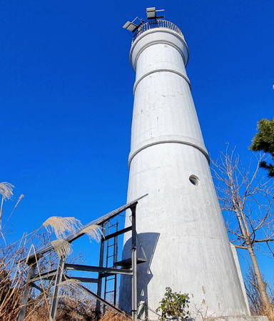
2006 (station established 1911). Active; focal plane 90 m (295 ft); white flash every 6 s. 16 m (52 ft) round cylindrical white concrete tower. A 2020 photo is at right, a 2023 closeup is available, and Google has a satellite view. According to a Korean article (no longer online), the 1911 skeletal tower was to be sent to the lighthouse museum at Homigot Light in Pohang. Located on a cliff on the northwestern corner of Hwangdeokdo, a small island off the northwestern coast of Chicheondo. The lighthouse is accessible by a hiking trail. Site open, tower closed. Admiralty M4341; NGA 16828.
* Muran Hang
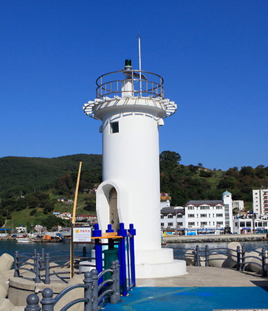
Date unknown. Active; focal plane about 12 m (39 ft); green light, pattern unknown. Approx. 8 m (26 ft) round cylindrical concrete tower, white with gray trim. Seong Rae has a photo, Lee Young-ju has a 2025 view across the harbor, and Google has a street view and a satellite view. Located on the main breakwater of a small harbor on the east side of Hwangdeokdo. Accessible by walking the pier. Site open, tower closed. Admiralty M4342.62.

Jangmok Township Lighthouses
Sobeombukdo (Sobombukdo, Sobombuk To)
Date unknown. Active; focal plane 13 m (43 ft); quick-flashing white light. 14 m (46 ft) round tower, painted yellow with one black horizontal band. Kwon Young-chan has a distant 2019 view and Google has a satellite view. Located on the northwest side of a small round island in the entrance to the harbor of Changmong, near the northern end of Geojedo. Accessible only by boat. Site status unknown. KR-2079; Admiralty M4342.7; NGA 16822.

Hwangdeokdo Light, Geoje, 2020
ex,Firenzecity.com photo by Songway20
 
Sageungseo (2)
2004. Active; focal plane 13 m (43 ft); two white flashes every 5 s. 12 m (39 ft) round concrete tower, painted black with one red horizontal band. Trabas has Capt. Peter's closeup 2025 photo, Kim Cheol Bong has a 2013 photo, and Google has a satellite view. The original light was damaged or destroyed by Typhoon Maemi in September 2003. Located on a dangerous reef off the northeastern corner of Geojedo. Accessible only by boat. Site status unknown. Admiralty M4351; NGA 16780.
Sangyu (2)
2004. Active; focal plane 11 m (36 ft); green flash every 6 s. 14 m (46 ft) round concrete tower, painted green. Trabas has Capt. Peter's 2025 photo, Kim Cheol Bong has a closeup 2011 photo, Kim Young Ho has a 2017 photo, and Google has a satellite view. The original light was damaged or destroyed by Typhoon Maemi in September 2003. Located just off the small harbor of Sangyu, at the northeastern corner of Geojedo just north of the Busan-Geoje Fixed Link bridge. Accessible only by boat. Site status unknown. KR-2077; Admiralty M4350.
Gyeokdo (Kyokdo, Kyok To)
2001. Active; focal plane 17 m (56 ft); three quick white flashes every 10 s. 16 m (52 ft) cylindrical concrete tower centered on a round concrete base. Tower painted black with one yellow horizontal band. Kim Cheol Bong has a 2013 photo and Google has an indistinct satellite view. Located on a rocky reef about 1 km (0.6 mi) off the northeast coast of Geojedo. Accessible only by boat. Site status unknown. KR-2076.5; Admiralty M4351.9; NGA 16829.
Huinyeo
Date unknown. Active; focal plane 18 m (59 ft); two white flashes every 5 s. 15 m (49 ft) round conical concrete tower painted black with one red horizontal band. Trabas has Capt. Peter's 2025 photo, Kim Cheol Bong has a photo, and Google has a satellite view. Located on a reef about 4 km (2.5 m) east of Geojedo. Accessible only by boat. Site open, tower closed. KR-2076.6; Admiralty M4351.98; NGA 16831.
* Isudo Hang South Breakwater
Date unknown. Active; focal plane 10 m (33 ft); red flash every 4 s. 8 m (26 ft) round red concrete tower. Kim Young-ho has a 2018 photo of both lighthouses, Kim Cheol Bong has a closeup 2013 photo, Kim Hyang-suk also has a photo showing both lighthouses, and Google has a satellite view. Located on the south breakwater of Isudo, an inhabited island off the east coat of Geojedo. Accessible by walking the pier. Site open, tower closed. KR-2076.3; Admiralty M4351.95.
* Isudo Hang North Breakwater
Date unknown. Active; focal plane 10 m (33 ft); green flash every 4 s. 8 m (26 ft) round white concrete tower. Kim Cheol Bong has a closeup and a photo of both lighthouses, Kim Hyang-suk also has a photo showing both lighthouses, and Google has a satellite view. Located on the north breakwater of Isudo. Accessible by walking the pier. Site open, tower closed. KR-2076.4; Admiralty M4351.96.
* Oepo (Ogapo) Hang East Breakwater (2?)
Date unknown. Active; focal plane 13 m (43 ft); red flash every 6 s. 8 m (26 ft) square cylindrical red concrete tower. Kim Cheol Bong has a very distant view. This light was probably replaced because it disappeared for a time from Google's satellite view. Located at the end of the east (outer) breakwater at Oepo. Accessible by walking the pier. Site open, tower closed. KR-2154; Admiralty M4340.75; NGA 16838.
* Oepo (Ogapo) Hang West Breakwater (2)
Date unknown (around 2020). Active; focal plane 9 m (30 ft); green flash every 6 s. 7 m (23 ft) round cylindrical white concrete tower. Gung Che-lin has a 2023 photo (seen at right) and Google has a satellite view. This light replaced a hexagonal white concrete tower; a 2010 photo of the earlier light is available and Bae Mi-Young has a 2018 photo. Located at the end of the west (inner) breakwater at Oepo. Accessible by walking the pier. Site open, tower closed. KR-2153; Admiralty M4340.7; NGA 16836.

Oepo Hang West Breakwater Light, Oepo, December 2023
Google Maps photo by Gung Che-lin


Okpo Area Lighthouses
Okpo is a highly urbanized ward on the central east coast of Geojedo. It is the home of the Hanwha Ocean Company, formerly known as the Daewoo Shipyard, one of South Korea's largest shipbuilders.

Hwangdo
2021. Active; focal plane 11 m (36 ft); six quick white flashes followed by one long white flash every 15 s. 13 m (43 ft) octagonal concrete tower with lantern and gallery, upper half painted yellow and lower half painted black. A 2021 photo is at right, a distant 2024 drone view is available but Google has an indistinct satellite view. Located on a reef north of the entrance to Okpo harbor. Accesible only by boat. Site open, tower closed. KR-2567.1; Admiralty M4340.63.
* Okpo Hang North Breakwater
Date unknown. Active; focal plane 11 m (36 ft); red flash every 4 s. 11 m (36 ft) round cylindrical red concrete tower. Shaun Jones has a 2015 photo and Google has a satellite view. Located at the end of the north breakwater of Okpo Hang, a bay sheltered by the Yangjiam Chwi peninsula. Accessible by walking the pier. Site open, tower closed. KR-2155; Admiralty M4340.6; NGA 16844.
* Okpo Hang South Breakwater
Date unknown. Active; focal plane 11 m (36 ft); green flash every 4 s. 11 m (36 ft) round cylindrical white concrete tower. Vanhuan Nguyen has a very distant view and Google has a satellite view. NGA lists the tower height as 7 m (23 ft), but Google's views show that the two breakwater lights are the same height. Located at the end of the south breakwater of Okpo Hang. Accessible by walking the pier. Site open, tower closed. KR-2156; Admiralty M4340.5; NGA 16840.
* Okpojora Hang East Breakwater
2010. Active; focal plane 10 m (33 ft); red flash every 5 s. 8 m (26 ft) round cylindrical red concrete tower. Kim Yoon Ha has a 2016 photo of both lighthouses and Google has a satellite view. Located at the end of the east breakwater at Okpojora Hang, a small harbor on the north side of Okpo Hang. Presumably accessible by walking the pier. Site open, tower closed. KR-2155.3; Admiralty M4340.65.
* Okpojora Hang West Breakwater
2007. Active; focal plane 10 m (33 ft); green flash every 5 s. 8 m (26 ft) round cylindrical white concrete tower. Kim Yoon Ha has a 2016 photo of both lighthouses and Google has a satellite view. Located at the end of the west breakwater at Okpojora Hang. Accessible by walking the pier. Site open, tower closed. KR-2155.1; Admiralty M4340.66.

Hwangdo Light, Okpo, January 2021
Google Maps photo by baibeulsyepeu

* Neungpo (Nungpo) Hang West Breakwater
Date unknown. Active; focal plane 12 m (39 ft); green flash every 6 s. 10 m (33 ft) round cylindrical red concrete tower. Kim Cheol Bong has a closeup 2013 photo, Taegab Han has a 2017 street view, and Google has a satellite view. Located at the end of the west breakwater at Neungpo Hang, a small harbor at the base of the Yangjiam Chwi peninsula. Accessible by walking the pier. Site open, tower closed. KR-2159; Admiralty M4340.45: NGA 16847.
* Neungpo (Nungpo) Hang East Breakwater
Date unknown. Active; focal plane 12 m (39 ft); red flash every 6 s. 10 m (33 ft) round cylindrical white concrete tower. Kim Tae-young's 2019 photo is at right, Kim Cheol Bong has a closeup 2016 photo, Taegab Han has a distant 2017 street view, and Google has a satellite view. Located at the end of the east breakwater at Neungpo Hang. Accessible by walking the pier. Site open, tower closed. KR-2158; Admiralty M4340.4; NGA 16846.
*** Yangjiam Chwi (2?)
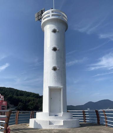
2008. Active; focal plane 60 m (197 ft); white flash every 6 s. 18 m (59 ft) octagonal cylindrical concrete tower with lantern and gallery. Entire lighthouse painted white. Jeong Gyeong-cheol's 2024 photo is at the top of this page, Jimmy Soondae has a 2020 photo, Kim Cheol Bong' has a good 2016 photo, a 2022 photo is available, Trabas has Capt. Peter's distant 2025 photo, Geun Cho Choi has a drone view, and Google has a satellite view. The tower is hollow, with an internal stairway and numerous openings with a spectacular view. Located at the end of narrow peninsula projecting from the east coast of Geojedo about 4 km (2.5 mi) north of Jangseungpo. Accessible by road. Site and tower open. . KR-2157; Admiralty M4340.3; NGA 16848.
Jangseungpo East Breakwater (2)
Date unknown. Active; focal plane 9 m (30 ft); red flash every 5 s. 8 m (26 ft) round cylindrical concrete tower, painted red. Sang Lee has a photo of both lighthouses and Google has a satellite view. NGA formerly described a skeletal tower at this location. Located at the end of the east breakwater of Jangseungpo. Site status unknown. KR-2160; Admiralty M4338; NGA 16852.
Jangseungpo West Breakwater (2)
Date unknown. Active; focal plane 9 m (30 ft); green flash every 5 s. 8 m (26 ft) round cylindrical concrete tower, painted white. A 2026 photo and a 2011 photo are available, Sang Lee has a photo of both lighthouses and Google has a satellite view. NGA formerly described a skeletal tower at this location. Located at the end of the west breakwater of Jangseungpo. Site status unknown. KR-2161; Admiralty M4340; NGA 16856.

Neungpo Hang East Breakwater Light, Okpo, November 2019
Google Maps photo by Kim Tae-young

Irun Township Lighthouses
Jisepo (Chisepo) Hang Breakwater West End
Date unknown. Active; focal plane 11 m (36 ft); green flash every 5 s. 9 m (30 ft) round cylindrical white concrete tower. No closeup photo available but Jo Gwang-rae has a distant view and Google has a satellite view and a very distant street view. Located at the west end of a detached breakwater at Jisepo, just south of the Yangjiam Chwi peninsula. Accessible only by boat. Site open, tower closed. KR-2163; Admiralty M4337.4; NGA 16857.5.
Jisepo (Chisepo) Hang Breakwater East End
Date unknown. Active; focal plane 11 m (36 ft); red flash every 5 s. 9 m (30 ft) round cylindrical red concrete tower. Jo Gwang-rae has a photo and Google has a satellite view. Located at the east end of a detached breakwater at Jisepo. Accessible only by boat. Site open, tower closed. KR-2162; Admiralty M4337.3; NGA 16857.
* Jisepo (Chisepo) Entrance Breakwater
Date unknown. Active; focal plane 12 m (39 ft); green flash every 4 s. 7 m (23 ft) round cylindrical white concrete tower. A 2021 photo is at right, Enfnal Seo has a closeup 2021 photo, and Google has a satellite view. Located at the end of a long breakwater on the south side of the entrance to Jisepo harbor. Accessible by walking the pier. Site open, tower closed. KR-2161.5; Admiralty M4337.2; NGA 16858.

Information available on lost lighthouses:

Notable faux lighthouses:


Jisepo Entrance Breakwater Light, Jisepo, November 2021
Google Maps photo by Zenith J

Adjoining pages: North: Changwon | Northeast: Southern Busan | Southwest: Southwest Geoje

Return to the Lighthouse Directory index | Ratings key

Posted December 4, 2007. Checked and revised July 23, 2026. Lighthouses: 26. Site copyright 2026 Russ Rowlett and the University of North Carolina at Chapel Hill.