Lighthouses of South Korea: Southwest Geoje

For most of its history Korea was an independent kingdom, or at least an autonomous kingdom under Chinese influence. This came to an end in 1910 when Japan annexed all of Korea. At the end of World War II in 1945 the 38° parallel was established as the dividing line between U.S. and Soviet zones of occupation, and in 1948 separate civil administrations were established in the two halves of the country. The Korean War (1950-53) ended in a draw with the armistice line falling close to the prewar 38° line. The Republic of Korea (ROK), commonly called South Korea, occupies the Korean peninsula south of the armistice line.

The name Korea, used internationally, is a Western version of Goryeo or Koryŏ (고려), the name of a kingdom that unified the country in the tenth century. From 1392 to 1897 the kingdom was known instead as Joseon or Chosŏn (조선). Today South Koreans usually call their country Hanguk (한국, literally "one country") and the official name of the Republic of Korea is Daehan Minguk (대한민국).

South Korea is divided into nine provinces and eight province-level cities. This page covers lighthouses of the southern and swestern coasts of the city of Geoje in Gyeongsangnam (South Gyeongsang) province on South Korea's south coast. The city occupies Geojedo (also called Koje-do or Geoje Island), a large, irregularly-shaped island, roughly 30 km (19 mi) north to south and 20 km (13 mi) east to west, lying south of Changwon and east of Tongyeong (Chungmu). It is connected to the mainland near Tongyeong by two bridges, and the Busan-Geoje Fixed Link, a bridge-tunnel link that opened in December 2010, connects it to Busan. The city includes all of Geojedo as well as several smaller nearby islands. It has a population of about 240,000.

Navigational aids in the ROK are regulated by the Ministry of Oceans and Fisheries (MOF). Management of lighthouses in Geoje is the responsibility of the Masan Regional Oceans and Fisheries Administration. The Korean Hydrographic and Oceanographic Administration (KHOA) publishes notices to mariners.

In 2000 South Korea adopted a Revised Romanization System to replace systems formerly used in the West. In the Revised System, the word for a lighthouse is deungdae (등대); dan (formerly tan) is a cape, seom (som) or do (to) is an island, am or amseog is a rock, man is a bay, and hang is a harbor. Some place names may be more familiar to Westerners in the spellings of older systems.

ARLHS numbers are from the ARLHS World List of Lights. KR numbers, where available, are from the Korean light list. Admiralty numbers are from volume M of the Admiralty List of Lights & Fog Signals. U.S. NGA List numbers are from Publication 112.

General Sources
Online List of Lights - Korea - South Coast
Photos by various photographers posted by Alexander Trabas.
Lighthouses to Visit
Information on three lighthouses provided by the Masan Office of Oceans and Fisheries.


Seoimal Light, Geoje, February 2020
Google Maps photo by Yun Yun

.Southeast Coast Lighthouses
* Seoimal (Soi Mal) (3)
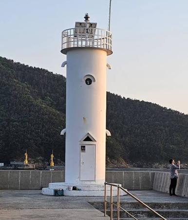
2006 (station established 1944). Active; focal plane 120 m (394 ft); white flash every 20 s. 10 m (33 ft) round hourglass-shaped concrete tower with lantern and gallery. Lighthouse painted white, gallery railing black. Several keeper's houses and other light station buildings. A closeup 2020 photo is at the top of this page, Musoo Kim has a 2023 photo, a 2018 photo is available, and Google has an indistinct satellite view. This lighthouse marks the narrowest passage of the Korea Strait; from here it is about 60 km (35 mi) southeast to the Japanese island of Tsushima. The first lighthouse, built during World War II, did not survive the hostilities. Located at the end of a sharp-pointed peninsula on the southeast side of Geojedo, about 15 km (9 mi) south of Jangseungpo. Accessible by road. Site open, tower closed. . Admiralty M4336; NGA 16860.
* Gujora Hang North Breakwater
2013. Active; focal plane 11 m (36 ft); green flash every 5 s. 9 m (30 ft) round metal tower, painted red and amusingly decorated with metal bands spiralling around the tower and a face at the top. Lim Chae-hoon has a 2023 photo, Kim Cheol Bong has a view of both breakwater lighthouses, and Google has a satellite view. Gujora is the cruise ship terminal for the greater Busan area. Located at the end of the north breakwater pier at Gujora. Accessible by walking the pier. Site open, tower closed. KR-2164; Admiralty M4336.21.
* Gujora Hang South Breakwater
2013. Active; focal plane 11 m (36 ft); green flash every 5 s. 9 m (30 ft) round metal tower, painted white and amusingly decorated with metal bands spiralling around the tower and a face at the top. A 2021 photo is available, Kevin Moore has a photo, Kim Cheol Bong has a view of both breakwater lighthouses and Google has a satellite view. Located at the end of the south breakwater pier at Gujora. Accessible by walking the pier. Site open, tower closed. KR-2164.1; Admiralty M4336.2.
* Oejorado (Oejora Do, Oedo)
Date unknown. Active; focal plane 10 m (33 ft); two red flashes every 6 s. 11 m (36 ft) red concrete tower rising from a pierhead structure; the lighthouse is shaped like a shoe. The light is perched atop the roof. Kim Cheol Bong's photo is at right, Youngdeuk Jo has a short closeup video, Seon Kwang Kim has a more distant view, and Google has a satellite view. Oedo is a small island about 3 km (2 mi) southwest of the Seoimal lighthouse. The island is the site of a popular formal garden and is readily accessible by ferry. Site open, tower closed. Admiralty M4335.9.
Dojangpo
Date unknown. Active; focal plane 11 m (36 ft); green flash every 4 s. 12 m (39 ft) robust concrete post light with gallery, mounted on a round concrete pier. Entire structure is green. Seo Jiwon has a 2019 photo, Kim Cheol Bong has a 2016 closeup, and Google has a street view and a satellite view. Located just offshore on the north side of a ragged peninsula at the southeastern corner of Geojedo, about 8 km (5 mi) southwest of the Seoimal lighthouse. Site open, tower closed. KR-2165.8; Admiralty M4335.8.

South Coast (Korea Strait) Lighthouses
Bugyeodo
Date unknown. Active; focal plane 24 m (79 ft); two white flashes every 5 s. 23 m (75 ft) tower, painted black with one red horizontal band. A photo and a distant view are available and Bing has a satellite view of the light on the reef. Located on an isolated rock in the Strait of Korea about 9 km (5.5 mi) south southeast of the Seoimal lighthouse. Accessible only by boat, although there is presumably a distant view from Seoimal and from other locations on the southeast coast of Geojedo. Accessible only by boat. Site status unknown. KR-2169; Admiralty M4335; NGA 16862.
* Dadaedapo (Tadaetap'o) Hang East Breakwater
Date unknown. Active; focal plane 13 m (43 ft); red flash every 5 s. 8 m (26 ft) octagonal concrete tower. Entire lighthouse is red. Kim Cheol Bong has a closeup photo and Google has a satellite view. Located on the east (really north) breakwater of a small boat harbor near the south end of Geojedo. Accessible by walking the pier. Site open, tower closed. KR-2167; Admiralty M4335.4; NGA 16861.

Oejorado Light, Geoje, May 2016
ex-Panoramio photo copyright Kim Cheol Bong; used by permission
* Dadaedapo (Tadaetap'o) Hang West Breakwater
Date unknown. Active; focal plane 14 m (46 ft); green flash every 5 s. 8 m (26 ft) octagonal concrete tower. Entire lighthouse is white. Kim Cheol Bong has a closeup photo and Google has a satellite view. Located on the west (really south) breakwater of a small boat harbor near the south end of Geojedo. Accessible by walking the pier. Site open, tower closed. KR-2168; Admiralty M4335.6; NGA 16861.5.
Dapodo
Date unknown. Active; focal plane 15 m (49 ft); two red flashes every 6 s. 14 m (46 ft) round red concrete tower. A 2023 photo and a distant 2023 photo is available and Google has a satellite view. Located just off the southernmost peninsula of Geoje. Accessible only by boat. Site status unknown. KR-2168.1; Admiralty M4335.7.
Daebyongdaedo (Taebyongdaedo)
2003. Active; focal plane 26 m (85 ft); green flash every 5 s. 21 m (69 ft) tower, painted green. No photo available but Google has a satellite view. Daebyongdaedo is a small island about 3 km (2 mi) off the southern tip of Geojedo. Located on the highest point of the islet. Accessible only by boat. Site status unknown. KR-2168.3; Admiralty M4331.75; NGA 16875.5.
Seokmundo (Seongmundo, Sokmun Do) (2)
Date unknown. Active; focal plane 16 m (52 ft); white flash every 5 s. 8 m (26 ft) round cylindrical white concrete tower. Kim Cheol Bong has a photo, Kim Dae-yong has a photo, and Google has a satellite view. Located on a small island about 4 km (2.5 mi) west of Daebyongdaedo. Accessible only by boat. Site status unknown. KR-2177; Admiralty M4331.7; NGA 16876.
Mangsangak
Date unknown. Active; focal plane 14 m (46 ft); white flash every 3 s. 8 m (26 ft) round cylindrical white concrete tower, perched atop a giant rock. Kim Cheol Bong has a view from the sea and Google has a satellite view. Located on a sharp cape at the southwestern point of Geojedo. Site status unknown. KR-2178; Admiralty M4331.6; NGA 16877.
* Daepo Hang
Date unknown. Active; focal plane 11 m (36 ft); red flash every 4 s. 8 m (26 ft) round cylindrical red concrete tower. Dong Kim has a 2021 photo, Kim Cheol Bong has a drone view, and Google has a satellite view. Located on the outer breakwater of Daepo/Geunpo harbor, sheltered by the Mangsangak peninsula. Accessible by walking the pier. KR-2178.5; Admiralty M4331.55; NGA 16876.9.
Geunpo Hang Outer Breakwater North Head
Date unknown. Active; focal plane about 12 m (39 ft); red light, pattern unknown. 8 m (26 ft) round cylindrical red concrete tower. Kim Cheol Bong has a photo and Google has a satellite view. Located on the outer breakwater of Daepo/Geunpo harbor. Accessible only by boat. Admiralty M4331.544.
* Geunpo Hang North Breakwater
Date unknown. Active; focal plane about 13 m (43 ft); green light, pattern unknown. 8 m (26 ft) round cylindrical white concrete tower. A 2024 photo is at right, Kim Cheol Bong has a photo and Google has a satellite view. Located on the north breakwater of Daepo/Geunpo harbor. Accessible by walking the pier. KR-2171.9; Admiralty M4331.545.
* Ssanggeun Hang
Date unknown. Active; focal plane 14 m (46 ft); red flash every 5 s. 10.5 m (34 ft) round cylindrical red concrete tower. Yong Min Seo has a photo and Google has a satellite view. Located on the breakwater of Ssanggeun harbor on the southwest coast of Geoje. Accessible by walking the pier. KR-2185.6; Admiralty M4330.6.

Geunpo North Breakwater Light, Daepo, April 2024
Google Maps photo by Michel S.

West Coast Lighthouses
Geoje (Koje) Man (Gudo)
Date unknown. Active; focal plane 15 m (49 ft); white flash every 5 s. 14 m (46 ft) round concrete tower, painted white. Kim Cheol Bong has a photo and Google has a satellite view. Located on the southwestern tip of Gudo, a small island in the center of Geoje Bay, about 12 km (7.5 mi) southeast of Tongyeong. Site status unknown. Admiralty M4330.5; ex-NGA 16904.
Daecho (Taech'o)
Date unknown. Active; focal plane 9 m (30 ft); red flash every 5 s. 11 m (36 ft) round concrete tower, painted red, mounted on a round concrete pier. Kim Cheol Bong has a photo and Google has a satellite view. Located off the west coast of Hwado in Geoje Bay about 2.5 km (1.5 mi) east southeast of Tongyeong harbor. Accessible only by boat. Site open, tower closed. KR-2200; Admiralty M4325.4; NGA 16911.
Banghwado (Panghwa Do) (1)
1911. Inactive since 2006. 10 m (33 ft) square steel skeletal tower rising from a small steel equipment cabinet. A photo is at right and Google has a satellite view. A unique survivor from its period, this light was awarded Lighthouse Cultural Heritage designation in September 2019. Located adjacent to the modern lighthouse. Site status unknown. Site manager: Hallyeohaesang National Park.
Banghwado (Panghwa Do) (2)
2006 (station established 1911). Active; focal plane 34 m (112 ft); white flash every 4 s. 15 m (49 ft) round cylindrical white concrete tower. Kim Cheol Bong has a view from the sea and Google has a satellite view. Located at the west end of an island in Geoje Bay about 2.5 km (1.5 mi) east of Tongyeong harbor. Site status unknown. Site manager: Hallyeohaesang National Park. Admiralty M4326; NGA 16912.

Northwest Coast (Seongpo Area) Lighthouses
Myeongdungdo (Myongdung Do)
Date unknown. Active; focal plane 29 m (95 ft); two white flashes every 6 s. 12 m (39 ft) round cylindrical concrete tower, painted white. Kim Cheol Bong has a photo (lighthouse in lower right corner, dwarfed by a huge electric power transmission tower); Google has a satellite view. Located on an island off the northwestern coast of Geojedo. Site status unknown. KR-2205; Admiralty M4329; NGA 16932.
Jiseok
Date unknown. Active; focal plane 10 m (33 ft); white flash every 5 s. 10 m (33 ft) round concrete tower, painted white. No photo available but Google has a satellite view. Located at the tip of a forested headland on the northwest coast of Geojedo. May be accessible only by boat. Site open, tower closed. KR-2203.1; Admiralty M4329.4.

1911 Banghwado Light, Geoje
unattributed press photo
Noruseom
Date unknown. Active; focal plane 9 m (30 ft); green flash every 5 s. 13 m (43 ft) round concrete tower, painted green. Kim Cheol Bong has a photo, Kim Soo Yeon has a photo, and Google has a satellite view. Located on the north side of a narrow channel leading westward into Seongpo on the northwest side of Geojedo. Accessible only by boat. Site status unknown. KR-2202; Admiralty M4329.5; NGA 16881.
* Seongpo (Songp'o) Hang West Breakwater
Date unknown. Active; focal plane 9 m (30 ft); red flash every 6 s. 8 m (26 ft) round hourglass-shaped red concrete tower. Park Sung-sik has a 2017 photo, Kim Cheol Bong has a photo, Kei Unggaro has a street view, and Google has a satellite view. Located at the end of the west breakwater in Seongpo on the northwest side of Geojedo. Accessible by walking the pier. Site open, tower closed. KR-2201.5; Admiralty M4330.1; NGA 16880.5.
* Seongpo (Songp'o) Hang East Breakwater
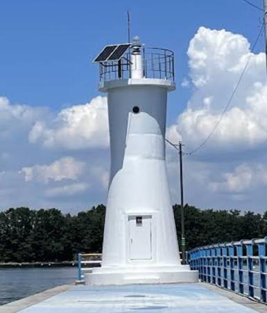
Date unknown. Active; focal plane 9 m (30 ft); green flash every 6 s. 8 m (26 ft) round tapered white concrete tower. Kim Cheol Bong has a photo, Kei Unggaro has a street view, and Google has a satellite view. Kee-Hyuck Kim has a 2011 photo that shows in the background the bridge connecting Geojedo to the smaller nearby island of Gajodo. Located at the end of the east breakwater in Seongpo. Accessible by walking the pier. Site open, tower closed. KR-2201.6; Admiralty M4330; NGA 16880.
Mangeumyeo
Date unknown. Active; focal plane 7 m (23 ft); two white flashes every 5 s. 8 m (26 ft) round concrete tower with gallery, mounted on a round concrete pier. Lighthouse painted black with one red horizontal band. No photo available and Google has only a distant satellite view. Located off the west coast of Gajodo. Accessible only by boat. Site open, tower closed. KR-2203.3; Admiralty M4330.35.
Dolkkeuchyeo (Gajodo)
Date unknown. Active; focal plane 10 m (33 ft); two white flashes every 10 s. 10 m (33 ft) round concrete tower with gallery, mounted on a round concrete pier. Lighthouse painted black with one red horizontal band. Kim Cheol Bong has a photo and Google has a distant satellite view. Located off the northwest coast of Gajodo. Accessible only by boat. Site open, tower closed. KR-2203.5; Admiralty M4330.3; NGA 16879.3.
Mangeumchodo
2021. Active; focal plane 8 m (26 ft); two white flashes every 5 s. 8 m (26 ft) round concrete tower painted black with one red horizontal band. No photo available but Google has a satellite view. Located about 600 m (3/8 mi) north of the Dolkkeuchyeo light. Accessible only by boat. Site open, tower closed. KR-2203; Admiralty M4330.25.
Gyedo
2022. Active; focal plane 8 m (26 ft); quick-flashing white light. 8 m (26 ft) round concrete tower, upper half painted black and lower half yellow. The light is at the left edge of a 2023 photo and Google has a satellite view. Located just off the end of a ridge projecting from the northwest corner of Gajodo. Accessible only by boat. Site open, tower closed. KR-2217.21; Admiralty M4330.23.

Seongpo Hang East Breakwater Light, February 2011
ex-Panoramio photo by Kee-Hyuck Kim

Information available on lost lighthouses:

Notable faux lighthouses:

Adjoining pages: Northeast: Northeast Geoje | Southwest: Hansan | West: Tongyeong

Return to the Lighthouse Directory index | Ratings key

Posted December 4, 2007. Checked and revised April 18, 2025. Lighthouses: 29. Site copyright 2025 Russ Rowlett and the University of North Carolina at Chapel Hill.