Lighthouses of Mexico: Central Gulf Coast

Mexico, officially the United Mexican States (Estados Unidos Mexicanos or EUM), is the second largest country of Latin America and the largest Spanish-speaking nation in the world. With an east coast on the Gulf of Mexico and Caribbean Sea and a long west coast on the Pacific Ocean it has by far the longest coastline in Latin America and, as a result, the largest number of lighthouses.

Mexico is a federal union of 31 states (estados) plus the capital district, and the states are subdivided into municipalities (municipios). This page includes the lighthouses of the central and southern regions of the Mexican state of Veracruz, which faces east on the Gulf of Mexico. Lighthouses of the Huasteca regions of northern Veracruz State are described on the Northern Gulf Coast page. Wedged between the Gulf on the east and the mountains of the Sierra Madre Oriental to the west, Veracruz state has a coastline about 650 km (400 mi) long. Veracruz City is the largest port, but there are many smaller ports.

In Spanish the word for a lighthouse is faro, baliza is a beacon, isla is an island, cabo is a cape, punta is a promontory or point of land, péñon is a rock, arrecife is a reef, bahía is a bay, ría is an estuary or inlet, estrecho is a strait, río is a river, and puerto is a port or harbor.

Mexican lighthouses are managed by the Port Captains and Maritime Affairs Unit (Unidad de Capitanías de Puerto y Asuntos Marítimos, UNICAPAM). Many of the larger light stations are staffed by resident civilian keepers.

ARLHS numbers are from the ARLHS World List of Lights. CF numbers are from the Mexican Cuaderno de Faros (Handbook of Lighthouses). Admiralty numbers are from volume J of the Admiralty List of Lights & Fog Signals. NGA Light List numbers are from NGA Publication 110.

General sources
Online List of Lights - Mexico - Gulf of Mexico
Photos posted by Alexander Trabas. Most of these photos were taken by Capts. Peter Mosselberger or Theo Hinrichs, better known as Capt. Peter and Capt. Theo.
Lighthouses in Mexico
Photos by various photographers available from Wikimedia.
World of Lighthouses - Mexico
Photos by various photographers available from Lightphotos.net.
Cuaderno de Faros 2023 - Golfo y Caribe
Official light list for the east coast, with tiny photos of each light.
Leuchttürme Mittelamerikas auf historischen Postkarten
Historic postcard images posted by Klaus Huelse.


Faro Benito Juárez, Veracruz, September 2023
Instagram photo by Adrian Crespo
Totonaca Region Lighthouses
Punta Cazones
Date unknown. Active; focal plane 15 m (49 ft); two white flashes every 10 s. 11 m (36 ft) square pyramidal white skeletal tower. No photo available but Google has an indistinct satellite view. Cazones de Herrera is a fishing port of about 25,000 residents at the mouth of the Río Cazones about 35 km (22 mi) southeast of Tuxpan. Located on the north side of the entrance to the river. Site status unknown. CF-30-370; Admiralty J4259.4; NGA 15331.
* Barra de Cazones
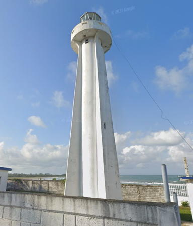
1970s. Active; focal plane 26 m (85 ft); white flash every 5 s. 16 m (52 ft) white concrete tower with four ribs, lantern and gallery. Lantern roof painted red. Wikimedia has a photo by Alejandro Linares Garcia, Jorge Ordoñez has a closeup, and Google has the 2023 street view seen at right and a satellite view. Located on the waterfront street in Cazones de Herrera. Site open, tower status unknown. ARLHS MEX-021; CF-30-365; Admiralty J4259.5; NGA 15332.
* Tecolutla (2)
Date unknown (station established 1906). Active; focal plane 25 m (82 ft); two white flashes every 10 s. 23 m (74 ft) "2-stage" masonry tower with lantern and two galleries: a cylindrical extension rises above the gallery of a conical lower section. The lighthouse, painted white, is also floodlit at night. Wikimdia has Alejandro Linares Garcia's photo, Fernando Castillo has a 2019 photo, Ivan Leos Santiago has 2023 photo, and Google has a 2023 street view and a satellite view. Located at the port captain's office on the Avenida Hidalgo in the center of Tecolutla, a small coastal town at the mouth of the Río Tecolutla about 65 km (40 mi) southeast of Túxpan. Site open, tower closed. . ARLHS MEX-066; CF-30-350; Admiralty J4260; NGA 15336.

Nautla Region Lighthouses
* Río Nautla (3)
Date unknown (station established 1906). Active; focal plane 30 m (98 ft); white flash every 6 s. 22 m (72 ft) concrete tower with lantern and double gallery. Lighthouse painted white, lantern roof red. A keeper's house is nearby. Jesús Enrique López Cadena has a 2019 photo, and Google has a 2022 street view and a satellite view. The lighthouse was repainted between Sybil White's March 2007 photo and Arturo Hugo's 2009 photo. Nautla is on the coast roughly halfway between Cabo Rojo and Veracruz. Located on the south side of the Río Nautla entrance; accessible by road. Site open, tower closed. ARLHS MEX-065; CF-30-345; Admiralty J4262; NGA 15348.

Barra de Cazones Light, Cazones, May 2023
Google Maps street view
* Punta Delgada (2)
Date unknown (station established 1906). Active; focal plane 46 m (151 ft); three white flashes every 25 s. 22 m (72 ft) cylindrical concrete tower with lantern and gallery. Lighthouse is unpainted concrete; lantern roof painted red. 1-story keeper's houses and other light station buildings. Omar Maximiliano has a 2021 photo, Martin Paredes has a closeup 2017 photo, Manolo Arrubarrena has a photo, another closeup is available, Jose Demetrio Sanchez Corro has a 2017 street view, and Google has a satellite view. Located on a headland (a rare hill on this coast) about 100 km (60 mi) southeast of Nautla. Site open, tower closed. . ARLHS MEX-179; CF-30-340; Admiralty J4266; NGA 15352.

Veracruz Harbor Lighthouses
Veracruz Northeast Breakwater
Date unknown. Active; focal plane 12 m (39 ft); red flash every 5 s. 7 m (23 ft) octagonal pyramidal concrete tower, covered with red ceramic tile. Trabas has Capt. Peter's closeup photo, Juan Rey Casas has a view from the sea, and Google has a satellite view. Located at the end of the breakwater on the northeast side of the harbor. Site status unknown. CF-30-300; Admiralty J4284; NGA 15384.
* Veracruz (1) (San Juan de Ulúa)
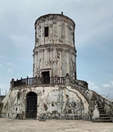
1796. Inactive since about 1890. Approx. 18 m (60 ft) ruined cylindrical masonry tower; lantern removed. Marisa Ofelia's 2023 photo is at right, Edgar Gerardo Galindo has a good photo, Carlos Eduardo Aguirre González has a second photo, Wikimedia has a 2009 photo, a closeup is available, Lighthouse Digest has Michel Forand's historic postcard view of the lighthouse when it was in service, Huelse has a second postcard view, Mikuel A. Ramos has a street view, and Google has a satellite view. This was the first lighthouse on Mexico's Gulf coast, created by placing a lantern and optics prefabricated in London atop the existing Torre de San Pedro del Castillo. The historic lens is on display at the Museo Histórico Naval in Mexico City. Located on a seaward corner of the star-shaped Fuerte de San Juan de Ulúa, the historic fortress that guarded Veracruz from early in the 16th century. Recognized as a national historic site, it has been operated as a museum by the Ministry of Culture since 1984. The fort is one of the principal tourist attractions of the city. Site open, museum open daily, tower closed. Owner/site manager: Instituto Nacional de Antropología e Historia (Fuerte de San Juan de Ulúa). . ARLHS MEX-148.
Veracruz Segundo Cambio de Rumbo (Second Change of Course) Range Front
Date unknown. Active; focal plane 32 m (105 ft); white flash every 3 s. 32 m (105 ft) square cylindrical skeletal tower. Trabas has Capt. Peter's photo and Google has a street view, but the tower is hard to see in Google's indistinct satellite view. This is the entrance range for the inner harbor of Veracruz. Located on the waterfront a short distance north of the First Range lights. Site status unknown. CF-30-325.5; Admiralty J4286.15.
Veracruz Segundo Cambio de Rumbo (Second Change of Course) Range Rear
Date unknown. Active; focal plane 32 m (105 ft); white flash every 3 s. 32 m (105 ft) square cylindrical skeletal tower. Trabas has Capt. Peter's photo and Google has a street view and a satellite view. Located on the waterfront about 200 m (220 yd) northwest of the front light. Site status unknown. CF-30-325.6; Admiralty J4286.2.

1796 Veracruz Light, San Juan de Ulúa, May 2023
Instagram photo by Marisa Ofelia
* [Veracruz Primer Cambio de Rumbo (First Change of Course) Range Front]
Date unknown. Active; focal plane 22 m (72 ft); white flash every 3 s. 20 m (60 ft) steel mast. The light is at the left edge of a drone view by Hugo Croix, Trabas has Capt. Peter's photo and Google has a satellite view. Located on the Muelle T pier, the "Pilot's Wharf." Site and tower closed but the light can be seen from the nearby waterfront. CF-30-325.3; Admiralty J4286.3.
* Veracruz Primer Cambio de Rumbo (First Change of Course) Range Rear
Date unknown. Active; focal plane 37 m (121 ft); white light, 1 s on, 1 s off. 37 m (121 ft) square cylindrical skeletal tower; the top of the tower carries a square daymark painted with red and yellow diagonal bands. This is an entrance range for the southern piers of Veracruz harbor. Trabas has Capt. Peter's photo and Google has a street view and an indistinct satellite view. Located on the waterfront near the Fiscal Piers. Site open, tower closed. CF-30-325.4; Admiralty J4286.31; NGA 15395.
* Veracruz (2) (Convento de San Francisco, Faro Benito Juárez)
1872. Inactive since 1910. Approx. 23 m (75 ft) square masonry clock tower at one corner of the 2-story Convento de San Francisco, a 17th century convent and church. Adrian Crespo's 2023 photo is at the top of this page, Wikimedia has Alejandro Linares Garcia's photo, Philo Nordlund has a photo, a 2018 photo is available, Huelse has a historic postcard view, and Google has a street view and an indistinct satellite view. It was in this building that Benito Juárez promulgated laws reforming the Mexican constitution in the late 1850s. Still recognized as having been a lighthouse, the tower is now called the Faro Benito Juárez. The building is now a historical museum. Located at the foot of the Calle Benito Juárez y Morelos in downtown Veracruz. Site open, museum open daily, tower closed. Owner/site manager: City of Veracruz (Museo Recinto de la Reforma). . ARLHS MEX-144.
Hotel Hawaii (Veracruz Entrance Range Rear)
Date unknown. Active; focal plane 31 m (102 ft); white light, 1 s on, 1 s off. Light mounted atop the 10-story Hotel Hawaii. Trabas has Capt. Peter's photo, a 2022 photo is available, and Google has a street view of the hotel and a satellite view. The front light is on the Muro de Pescadores (see below). Located on the Paseo El Malecón on the Veracruz waterfront. Site open, tower closed. ARLHS MEX-081; CF-30-325.2; Admiralty J4286.1; NGA 15392.1.
* Veracruz (3) (Faro Venustiano Carranza)
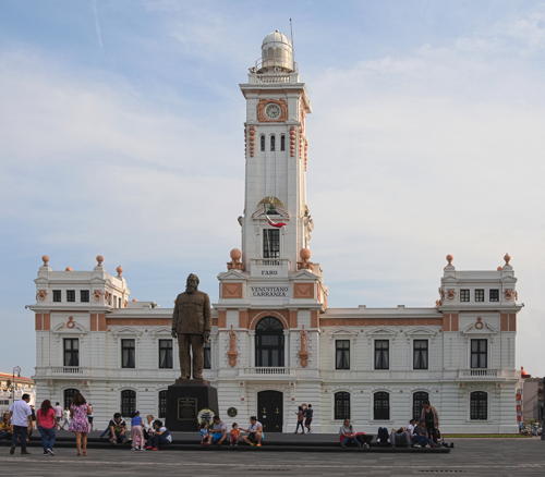
1910 (Salvador Echegaray). Inactive since 1952, but a decorative light is displayed. 23 m (75 ft) (?) square cylindrical tower rising from the 2-story Museo Venustiano Carranza. C.V. Montuy's photo is at right, Arturo Jimenez has a good photo, Lesli Sacadas has an excellent 2017 photo, and Google has a street view and a satellite view. This building played a crucial role in Mexico's 1913-1917 revolution, and for a time in 1914-15 it served as the national capitol. It is named for Venustiano Carranza, the hero of the revolution and president of Mexico from 1917 to 1920. Owned by the Navy, since 1935 the building has housed the headquarters of the Third Naval District. It also includes a historical museum. After 1952 the light was moved atop the Banco de México (now the Pemex building) next door. In 1964 it was moved to the top of the Hotel Diligencias, and in the early 1990s it was moved again to the top of the Hotel Hawaii. The general navigation light was finally discontinued in or about 2002, but the rear light of the entrance range remains on the hotel (see previous entry). Located on the waterfront (the Malecón) in downtown Veracruz. It is open daily except Mondays (free). Owner/site manager: Marina Armada de México. Site open, museum open daily, tower closed. . ARLHS MEX-149; ex-Admiralty J4298; ex-NGA 15404.

Faro Venustiano Carranza, Veracruz, January 2020
Wikimedia Creative Commons photo by Cvmontuy
Muro de Pescadores (Veracruz Entrance Range Front)
Date unknown. Actve; focal plane 24 m (79 ft); white flash every 3 s. 24 m (79 ft) concrete post with gallery rising from a round 2-story concrete base. The concrete is a pale yellow color. Trabas has Capt. Peter's photo, Jesus Vazquez has a 2023 photo, the light is on the right in a photo on Lightphotos.net, and Google has a satellite view and a street view across the harbor. The rear light of the range is mounted on the top of the Hotel Hawaii (see above). Located at the end of the south inner breakwater of Veracruz. Accessible by walking the breakwater, which is popular with fishermen. Site open, tower closed. CF-30-325.1; Admiralty J4286; NGA 15392.
* Veracruz Outbound Range Rear (Acuario Viejo, "Old Aquarium")
Date unknown. Active; focal plane 12 m (39 ft); white light, 1 s on, 1 s off. 12 m (39 ft) square pyramidal aluminum skeletal tower carrying a slatted daymark. Trabas has Capt. Peter's photo, Luis F. Cedillo has a 2022 photo, and Google has a 2022 street view and a satellite view. The range guides ships leaving the harbor. The front light is on a post located midway on the Muro de Pescadores. Located at a plaza at the base of the Southeast Breakwater. Site open, tower closed. CF-30-325.8; Admiralty J4286.41; NGA 15392.6.
* Veracruz Southeast Breakwater ("Faro Verde")
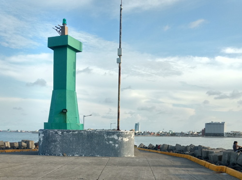
Date unknown. Active; focal plane 10 m (33 ft); green flash every 5 s. 7 m (23 ft) octagonal pyramidal concrete tower, painted green. A photo by Carlos Rodrigues is at right, Ricardo Rosas also has a 2018 photo, Trabas has Capt. Peter's closeup photo, Eduardo Castro has a 2022 photo, the light is on the left in a photo on Lightphotos.net, Mikuel Ramos has a closeup street view, and Google has a satellite view. Known locally as the Faro Verde (Green Lighthouse). Located at the end of the breakwater on the southeast side of the harbor. Accessible by walking the pier. Site open, tower closed. . CF-30-305; Admiralty J4282; NGA 15388.

Faro Verde (Southeast Breakwater Light), Veracruz, July 2018
ex-Google Plus photo by Carlos Rodrigues

Veracruz Reefs Lighthouses

The Veracruz Reefs (Sistema Arrecifal Veracruzano) are 23 coral reefs fringing the approach to the harbor of Veracruz. Protected as the Veracruz Reef System National Park, the reefs are very popular sites for scuba diving.

La Galleguilla
Date unknown. Active; focal plane 11 m (36 ft); two white flashes every 10 s. 11 m (36 ft) round white concrete tower mounted on a round concrete pier. Lightphotos.net has Capt. Peter's photo and Google has a satellite view. According to the Admiralty the light was moved to a buoy in 2020; apparently this was temporary while the tower was restored. Located at the south end of the Galleguilla reef, about 4 km (2.5 mi) north of the Veracruz harbor entrance. Accessible only by boat. Site open, tower closed. CF-30-290; Admiralty J4271; NGA 15356.
Arrecife Blanquilla Nord
Date unknown. Active; focal plane 15 m (49 ft); four red flashes every 16 s. 14 m (46 ft) two-stage tower, with a round post mounted atop an octagonal pyramidal concrete tower. Lighthouse red with narrow white horizontal bands. Trabas has Capt. Peter's photo and Google has a satellite view. Located at the northwestern end of the reef, about 4 km (2.5 mi) northeast of the Veracruz harbor entrance. Accessible only by boat. Site open, tower closed. CF-30-280; Admiralty J4270; NGA 15360.
Arrecife Blanquilla Sud
Date unknown. Active; focal plane 14 m (46 ft); two red flashes every 10 s. 14 m (46 ft) round cylindrical concrete tower, painted red with narrow white horizontal bands. Tony Quezada has a 2025 drone view, Trabas has Capt. Peter's photo, and Google has a satellite view. Located at the southern end of the reef. Accessible only by boat. Site open, tower closed. CF-30-275; Admiralty J4270.2; NGA 15364.
Anegada de Adentro
Date unknown. Active; focal plane 11 m (36 ft); three green flashes every 12 s. 10 m (33 ft) round cylindrical concrete tower, painted green. Trabas has Capt. Peter's photo and Google has a satellite view. The Anegada de Adentro is an outer reef located about 12 km (7.5 mi) east northeast of the harbor entrance. (Anegada, "flooded," refers to reef that is always awash.) Located at the northwestern end of the reef. Accessible only by boat. Site open, tower closed. CF-30-285; Admiralty J4272; NGA 15368.
Isla Verde
Date unknown. Active; focal plane 8 m (26 ft); four white flashes every 16 s. 8 m (26 ft) hexagonal pyramidal concrete tower, mounted on a hexagonal concrete base. Lighthouse covered with red ceramic tile. Wikimedia has Iriri Hye's 2016 photo, Raul Gutierrez has a 2019 photo, Trabas has Capt. Peter's closeup, and Google has a satellite view. This light is close to the approach channel for large ships. Located on an islet at the southern end of the reef, about 7 km (4.5 mi) east of the harbor entrance. Accessible only by boat. Site open, tower closed. CF-30-270; Admiralty J4274; NGA 15372.
Isla de Sacrificios (2)
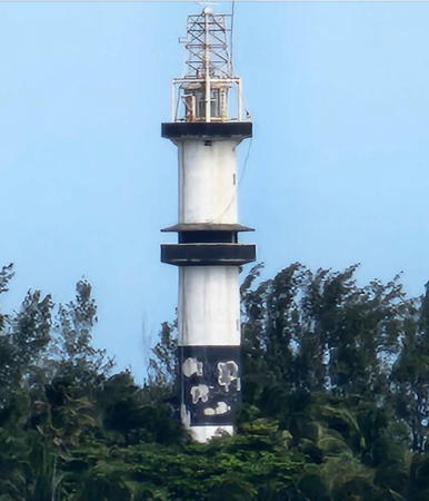
1964? (station established 1894). Active; focal plane 42 m (138 ft); flash every 15 s, white, red or green depending on the direction of approach. 39 m (128 ft) cylindrical concrete (?) tower with double gallery, painted with black and white horizontal bands. Lantern topped by a square skeletal tower to elevate the light. A 2022 photo by Olivia Presa is at right, Trabas has Capt. Peter's photo, Laura Fern has a 2007 photo, Wikimedia has a view from the water by Ricardo Rodriguez, Fernando M. Imperiale has a 2017 photo, Arturo Chavez has a 2016 street view, and Google has a satellite view. This lighthouse, one of Mexico's tallest, is a familiar sight for anyone arriving in Veracruz by sea. The original lighthouse was a 9 m (30 ft) cast iron tower; Huelse has posted a postcard image and Lighthouse Digest has Michel Forand's historic photo. The lighthouse is on a small island southeast of the harbor of Veracruz; the island is famous as the place where the conquistador Hernán Cortés landed in 1519. Accessible only by boat. The island is owned by the Navy and said to be closed to visitors but it seems that many ignore this restriction. Site and tower closed. . ARLHS MEX-145; CF-30-240; Admiralty J4278; NGA 15380.

Isla de Sacrificios Light, Veracruz Reefs, November 2022
Google Maps photo by Olivia Presa

Antón Lizardo Reef Lighthouses
These reefs lie off the cape of Antón Lizardo, southeast of Veracruz.

#Anegada de Afuera (1)
Date unknown. Replaced sometime before 2017. This was a 12 m (39 ft) square pyramidal concrete tower, painted white. No photo available. Trabas has Capt. Peter's photo of the active light on a post (focal plane 10 m (33 ft); four white flashes every 16 s) and Bing has a distant satellite view. Located at the northwestern point of a large reef, about 7 km (4.2 mi) northwest of the Arrecife Santiaguillo lighthouse. Accessible only by boat. Site open, tower closed. Active light: CF-30-225; Admiralty J4319; NGA 15440.
Arrecife Santiaguillo (2)
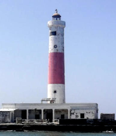
1934 (station established 1898). Active; focal plane 32 m (105 ft); two flashes, alternating red and white, every 10 s. 32 m (105 ft) cylindrical tower, attached to a 1-story concrete keeper's house. Lighthouse painted with red and white horizontal bands. A 2023 photo by Carlos Mesta Fernández is at right, Laura Elena Rosado has a good 2007 photo, Trabas has Capt. Peter's photo, and Google has a satellite view. This isolated island is off the coast about 30 km (20 mi) east southeast of Veracruz. Accessible only by boat. Site open, tower closed. ARLHS MEX-076; CF-30-235; Admiralty J4318; NGA 15436.
Arrecife Cabezo Norte
Date unknown. Active; focal plane 9 m (30 ft); two white flashes every 10 s. 9 m (30 ft) square pyramidal concrete tower on a square concrete base. Entire lighthouse is white. No photo available but Bing has a distant satellite view. The Cabezo reef is the largest of the Antón Lizardo reefs; it is elliptical with a length of about 5.5 km (3.5 mi). Located at the northwest end of the reef about 10 km (6 mi) east of the Isla de Enmedio. Accessible only by boat. Site open, tower closed. CF-30-205; Admiralty J4317; NGA 15428.
Arrecife Cabezo Sur
Date unknown. Active; focal plane 8 m (26 ft); white flash every 6 s. 8 m (26 ft) post rising from a square concrete base. Entire lighthouse is red. No photo available but Bing has a distant satellite view. Located at the southeast end of the reef. Accessible only by boat. Site open, tower closed. CF-30-200; Admiralty J4317.2; NGA 15432.
Arrecife Blanca
Date unknown. Active; focal plane 10 m (33 ft); two white flashes every 10 s. 10 m (33 ft) square pyramidal concrete tower painted white and mounted on a concrete base. Trabas has Capt. Peter's closeup photo and Google has a satellite view. Located on a reef about 3 km (1.8 mi) north northwest of Antón Lizardo. Accessible only by boat. Site open, tower closed. CF-30-220; Admiralty J4310; NGA 15408.

Arrecife Santiaguillo Light, Antón Lizardo Reefs, July 2023
Google Maps photo by Carlos Mesta Fernández
Arrecife El Giote
Date unknown. Active; focal plane 9 m (30 ft); white flash every 6 s. 7 m (23 ft) square cylindrical concrete skeletal tower with gallery. Entire structure is red. Trabas has Capt. Peter's closeup photo and Google has a satellite view and a distant 2015 street view. Located about 500 m (1/3 mi) off the beach at Antón Lizardo. Accessible only by boat but visible distantly from the beach. Site open, tower closed. CF-30-215; Admiralty J4308; NGA 15412.
Isla de Enmedio (2)
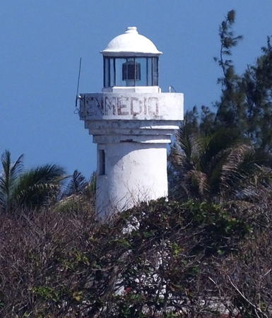
Date unknown (station established 1893). Active; focal plane 14 m (46 ft); three flashes, alternating white, red, and green, every 12 s. 14 m (46 ft) round concrete tower with lantern and gallery. Entire lighthouse painted white; the name "Isla de Enmedio" is written in black on the gallery. Keeper's house. Staffed light station. Trabas has Capt. Peter's photo (also seen at right), Javier Lopez has a 2008 closeup, an aerial view is available, and Bing has a satellite view. The reef is off the coast about 5 km (3 mi) north of Antón Lizardo and 30 km (20 mi) southeast of Veracruz. Located on an island at the north end of the Salmedina reef. Accessible only by boat. Site open, tower open by arrangement with the keeper. . ARLHS MEX-032; CF-30-230; Admiralty J4314; NGA 15420.
Arrecife El Rizo (2)
Date unknown (station established 1900). Active; focal plane 12 m (39 ft); three white flashes every 12 s. 10 m (33 ft) square cylindrical concrete skeletal tower with gallery. The lighthouse is covered with red tiles. Trabas has Capt. Peter's distant view and Google has a satellite view. Located near the southeast end of a barely-exposed reef about 5 km (3 mi) southeast of the Isla de Enmedio. Accessible only by boat. Site open; if you can get there, the tower can be climbed. CF-30-195; Admiralty J4316; NGA 15424.

Papaloapan Region Lighthouses
* Antón Lizardo
2017. Active; focal plane 34 m (112 ft); white flash every 4 s. 35 m (115 ft) square cylindrical masonry tower rising from one of the buildings of the Mexican Naval Academy. Trabas has Capt. Peter's photo and Google has a 2023 street view and a satellite view. Located on the campus of the academy in Antón Lizardo. Site open, tower closed. Site manager: Universidad Naval. Admiralty J4308.3.
* [El Fortín (Punta Alvorado)]
Date unknown. Active; focal plane 9 m (30 ft); white flash every 6 s. 7 m (23 ft) square cylindrical concrete tower painted white with a red top. Ruben Palomo has a 2020 photo and Google has a street view and a satellite view. Alvarado is a town of about 25,000 residents located 65 km (40 mi) southeast of Veracruz. The town is built at the inlet connecting the Gulf to the Laguna de Alvorado. This light guides vessels leaving the lagoon for the sea. Located on the waterfront avenue (Calle Marco A. Muñoz) at the Calle Luis H. Reyes. Site open, tower closed. CF-30-185; Admiralty J4326; NGA 15452.

Isla de Enmedio Light, Antón Lizardo Reefs, March 2019
photo copyright Capt. Peter Mosselberger; used by permission
Alvarado (Monte Simón) (1)
1930. Inactive since 2012. 8 m (26 ft) square concrete post centered on a square 1-story concrete base, adjacent to a keeper's house. Entire lighthouse painted red. Carlos Rodrigues has a 2018 closeup photo, a distant Google street view from September 2012 shows the old and new lighthouses, and Google has a photo of the two lighthouses and a satellite view of the station. NGA's listing still describes this lighthouse. The lighthouse marks the east side of the entrance to the Laguna de Alvarado, about 65 km (40 mi) southeast of Veracruz. Site status unknown.
Alvarado (Monte Simón) (2)
2012. Active; focal plane 52 m (171 ft); three white flashes every 12 s. 22 m (72 ft) round cylindrical concrete tower with lantern and gallery, painted white with a red horizontal band. Isabelino Alcudia Leon has a photo, Jesus Ruiz Angel has a more distant view, Trabas has Capt. Peter's view from the sea, a distant Google street view from September 2012 shows the old and new lighthouses, and Google has a 2024 street view and a satellite view of the station. The lighthouse marks the east side of the entrance to the Laguna de Alvarado, about 65 km (40 mi) southeast of Veracruz. Site status unknown. ARLHS MEX-098; CF-30-170; Admiralty J4324; NGA 15444.

Los Tuxtlas Region Lighthouse
Punta Roca Partida (2)
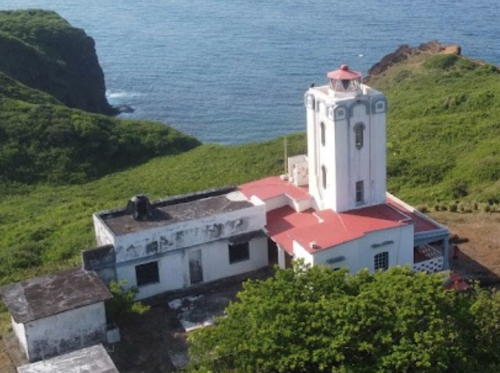
Date unknown (station established 1909). Active; focal plane unknown (the published figure, 15 m, cannot be correct); four white flashes every 16 s. 13 m (43 ft) square cylindrical concrete tower with lantern and gallery, rising from the front end of a 1-story keeper's house. Lighthouse painted white; lantern roof is red. Daniel Guzmán's 2022 drone view is at right, Alex Ayala has a 2023 photo, Francisco Lermo has a 2024 view, Wikimedia's 2014 photo by Alejandro Linares Garcia shows the lighthouse painted with red and white horizontal bands, and Google has a satellite view. Located on a headland at Punta Roca Partida. Site status unknown. ARLHS MEX-068; CF-30-165; Admiralty J4330; NGA 15456.

Punta Roca Partida Light, Los Tuxtlas, May 2022
Google Maps photo by Daniel Guzmán

Olmeca Region Lighthouses
Punta Zapotitlán
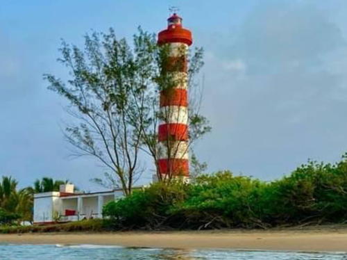
Date unknown (probably 1920s). Active; focal plane 30 m (98 ft); white flash every 6 s. 28 m (92 ft) round concrete tower with lantern and gallery, painted with red and white horizontal bands. Ilse Denisse Garrido Carranza's 2023 view from the sea is at right, she also has a drone view, Tonatiuh MeCa has a photo, another photo is available, José Antonio Islas has a 2024 photo, and Google has a satellite view. Punta Zapotitlán is a prominent headland jutting into the Bay of Campeche about 150 km (90 mi) east southeast of Veracruz. Site status unknown. ARLHS MEX-063; CF-30-160; Admiralty J4332; NGA 15460.
* Coatzacoalcos West Breakwater
Date unknown. Active; focal plane 17 m (56 ft); red flash every 5 s. 14 m (46 ft) tower with gallery but no lantern, painted red. Trabas has Capt. Peter's photo, Rodolfo Imai Escalante Zepeda has a 2023 photo, Arturo Sagredo has a street view, and Google has a satellite view. The breakwater lighthouses are now painted in solid colors instead of with the white horizontal bands seen in Samuel Rocha's 2008 photo. This light appears freshly painted in a 2018 photo by Carlos Glez. Accessible by walking the breakwater in Coatzacoalcos. Site open, tower closed. . ARLHS MEX-181; CF-30-020; Admiralty J4337; NGA 15480.
* Coatzacoalcos East Breakwater
Date unknown. Active; focal plane 17 m (56 ft); green flash every 5 s. 14 m (46 ft) tower with gallery but no lantern painted green. Trabas has Capt. Peter's photo, Daniel Zacarias has a 2022 photo, and Google has a street view and a satellite view. This light appears freshly painted in a 2017 photo by Maye Cordova. Accessible by walking the breakwater. Site open, tower closed. ARLHS MEX-182; CF-30-025; Admiralty J4338; NGA 15476.

Punta Zapotitlán Light, La Perlo del Golfo, June 2023
Google Maps photo by Daniel Guzmán
Coatzacoalcos Entrance Range Front
Date unknown. Active; focal plane 33 m (108 ft); white flash every 3 s. 33 m (108 ft) square pyramidal skeletal tower painted with red and white horizontal bands. Trabas has Capt. Peter's photo and Google has a satellite view. Located on the east side of the dredged entrance channel, about 4 km (2.5 mi) south of the breakwater lights. Site status unknown. CF-30-030; Admiralty J4339; NGA 15468.
Coatzacoalcos Entrance Range Rear
Date unknown. Active; focal plane 55 m (180 ft); white flash every 2 s. Approx. 60 m (197 ft) square skeletal tower painted with red and white horizontal bands. Trabas has Capt. Theo's photo and Google has a satellite view. Located 290 m (317 yd) south southeast of the front light. Site status unknown. CF-30-030.1; Admiralty J4339.1; NGA 15472.
**** Coatzacoalcos (Allende, Cerro del Gavilan, (2)
1945. Inactive since 1982. 21 m (69 ft) octagonal white concrete tower with lantern. The lighthouse is in the background of the 2018 photo by Hilda Zamudio Gonzalez seen at right, a 2024 photo is available, Erick Ortiz has a 2018 photo of the new and old lighthouses, and Google has a street view and a satellite view. The lighthouse was completed in 1943 but not lighted until the end of World War II in 1945. The lighthouse is adjacent to the city museum, the Museo del Faro. Located on a hill southeast of the harbor entrance in the city of Coatzacoalcos. Site and tower open. Site manager: Municipio de Coatzacoalcos.
**** Coatzacoalcos (Allende, Cerro del Gavilan, (3)
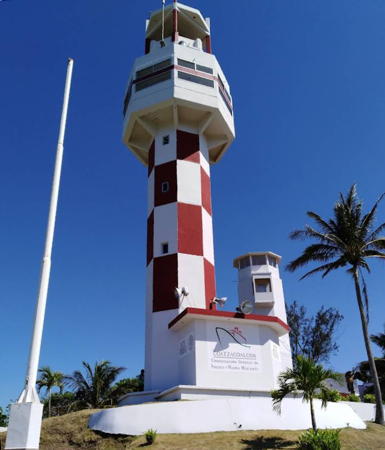
1982. Active; focal plane 54 m (177 ft); two white flashes every 18 s. 14 m (46 ft) octagonal concrete tower crowned by a large observation platform and lantern. The lighthouse has been repainted in a red and white checkerboard pattern, as seen in Capt. Peter Mosselberger's 2021 photo and the 2018 photo by Hilda Zamudio Gonzalez at right. Erick Ortiz has a 2018 photo of the new and old lighthouses and Google has a street view and a satellite view. Located on a hill southeast of the harbor entrance in the city of Coatzacoalcos. Site and tower open. Site manager: Municipio de Coatzacoalcos. ARLHS MEX-026; CF-30-010; Admiralty J4336; NGA 15464.
Tonalá (2)
1990s (station established 1908). Active; focal plane 23 m (75 ft); three white flashes every 12 s. 17 m (56 ft) square cylindrical masonry tower painted with red and white horizontal bands. A closeup photo is available, Mapio.net has a photo, the top of the tower can be seen in a Google street view, and Google also has a satellite view. Located in Tonalá on the west side of the entrance to the Río Tonalá, which forms the border between Veracruz and Tabasco states. Site status unknown. ARLHS MEX-134; CF-30-005; Admiralty J4348; NGA 15492.

New and old Coatzacoalcos Lights, Coatzacoalcos, May 2018
Google Maps photo by Hilda Zamudio Gonzalez

Information available on lost lighthouses

Notable faux lighthouses:

Adjoining pages: North: Northern Gulf Coast | East: Southern Gulf Coast

Return to the Lighthouse Directory index | Ratings key

Posted December 2004. Checked and revised April 9, 2025. Lighthouses: 41. Site copyright 2025 Russ Rowlett and the University of North Carolina at Chapel Hill.