Lighthouses of Mexico: Northern Gulf Coast

Mexico (officially the United Mexican States (Estados Unidos Mexicanos or EUM) is the second largest country of Latin America and the largest Spanish-speaking nation in the world. With an east coast on the Gulf of Mexico and Caribbean Sea and a long west coast on the Pacific Ocean it has by far the longest coastline in Latin America and, as a result, the largest number of lighthouses.

Mexico is a federal union of 31 states (estados) plus the capital district, and the states are subdivided into municipalities (municipios). This page describes lighthouses of the northeastern corner of Mexico including the state of Tamaulipas and the Huasteca regions in the northern portion of the state of Veracruz. This coast, facing east on the Gulf of Mexico, consists mostly of sandy barrier islands and beaches similar to the coast of neighboring southern Texas. The important ports of Altamira and Tampico are at the extreme southern end of Tamaulipas and the port of Tuxpan is in the Huasteca region of Veracruz.

In Spanish the word for a lighthouse is faro, baliza is a beacon, isla is an island, cabo is a cape, punta is a promontory or point of land, péñon is a rock, arrecife is a reef, bahía is a bay, ría is an estuary or inlet, estrecho is a strait, río is a river, and puerto is a port or harbor.

Mexican lighthouses are managed by the Port Captains and Maritime Affairs Unit (Unidad de Capitanías de Puerto y Asuntos Marítimos, UNICAPAM). Many of the larger light stations are staffed by resident civilian keepers.

ARLHS numbers are from the ARLHS World List of Lights. CF numbers are from the Mexican Cuaderno de Faros (Handbook of Lighthouses). Admiralty numbers are from volume J of the Admiralty List of Lights & Fog Signals. NGA Light List numbers are from NGA Publication 110.

General sources
Online List of Lights - Mexico - Gulf of Mexico
Photos posted by Alexander Trabas. Most of these photos were taken by Capt. Peter Mosselberger ("Capt. Peter").
Construcción
A Flickr.com folder of photos from the construction of new lighthouses in Tamaulipas by ISNI.
Lighthouses in Mexico
Photos by various photographers available from Wikimedia.
World of Lighthouses - Mexico
Photos by various photographers available from Lightphotos.net.
Cuaderno de Faros 2023 - Golfo y Caribe
Official light list for the east coast, with tiny photos of each light.
Leuchttürme Mittelamerikas auf historischen Postkarten
Historic postcard images posted by Klaus Huelse.
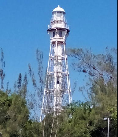

Tampico (Ciudad Madero) Light, Tampico, September 2023
Google Maps photo by David Sloat
Lighthouses of Tamaulipas

Matamoros Lighthouses
Río Bravo (Matamoros, Faro de Bagdad) (2)
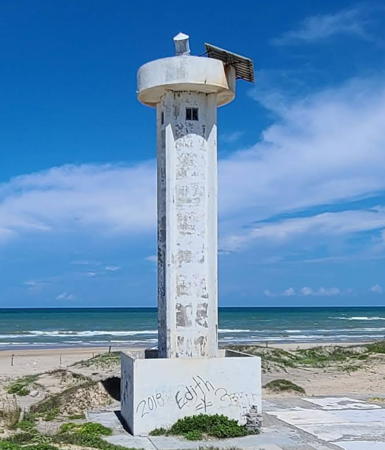
2007 (station establishment date unknown). Active; focal plane 18 m (59 ft); white flash every 6 s. 16 m (52 ft) round cylindrical white concrete tower with gallery, and four ribs. The lantern was removed sometime in 2017-18. Rafael Axel has the 2021 photo at right, Leonel Muri has a 2017 photo is at right, ISNI has a photo of the new lighthouse, Daniel Padilla has a 2018 photo, and Google has a satellite view and a distant street view across the mouth of the Río Grande. Located in Matamoros on the south side of the entrance to the Río Grande, which is called the Río Bravo del Norte in Mexico. There is little or no navigation through the entrance, so the light is primarily a marker for the international border. Site status unknown. ARLHS MEX-037; CF-28-145; Admiralty J4229.5; NGA 15203.
Canal de Chávez
Date unknown. Active; focal plane 12 m (39 ft); white flaash every 5 s. 10 m (33 ft) round cylindrical concrete tower with gallery, painted white. 300 mm lens mounted on a short mast; no lantern. Daniel Padilla has a distant view, Miguel Ramos has a 2019 view, and Google has a satellite view. "Canal" suggests that the light is supposed to mark a channel through the barrier beach. In fact the satellite images show a former channel that has silted shut completely. The light does mark the easternmost bulge of the coastline. Although the light was dropped by the Admiralty it remains as active in the Cuaderno de Faros. Located on the beach 25 km (15 mi) south of the Río Bravo. Site open by not easy to reach, tower closed. ARLHS MEX-177; CF-28-140; ex-Admiralty J4229.55; NGA 15203.2.
* El Mezquital (2)
2013 (station establishment date unknown). Active; focal plane 25 m (82 ft); three white flashes every 15 s. 26 m (85 ft) round cylindrical white concrete tower with lantern, gallery, and four ribs; lantern roof is red. Daniel Padilla has a fine 2018 photo, another 2018 photo is available, Google has a satellite view. ISNI has a photo of the nearly completed tower and another ISNI photo shows an early stage of construction of the tower. The original lighthouse was a skeletal tower reinforced with concrete legs. El Mezquital is a small fishing port and naval station at the northern end of the Laguna Madre; it is connected to the sea by a short canal through the barrier beach. Located at the end of highway 5 about 135 km (84 mi) south of the Río Bravo. Site open, tower closed. ARLHS MEX-031; CF-28-135; Admiralty J4230; NGA 15203.1.

San Fernando Lighthouses
* La Carbonera (Carboneras) (2)
2010. Active; focal plane 12 m (38 ft); white flash every 6 s. 10 m (33 ft) round cylindrical white concrete tower with gallery; gallery painted blue. 300 mm lens mounted on a small lantern painted with red and white horizontal bands. ISNI has a photo of the new lighthouse, and Google has a distant 2022 street view and an indistinct satellite view. Located off highway 20 on the waterfront of La Carbonera, a fishing village on the Laguna Madre about 60 km (38 mi) south of El Mezquital. Site open, tower closed. ARLHS MEX-178; CF-28-130; Admiralty J4230.4; NGA 15206.

Río Bravo Light, Matamoros, July 2021
Google Maps photo by Rafael Axel
Punta Piedra (Punta de Piedra) (2)
2009. Active; focal plane 25 m (82 ft); two white flashes every 10 s. 25 m (82 ft) round cylindrical white concrete tower with lantern and gallery. Lantern roof is red. ISNI has a photo of the completed lighthouse, Uriel Martinez has a 2019 photo, Karlita Davila has a 2021 photo, and Google has a satellite view. This new lighthouse replaced a light on a short post. Located at the end of a sandbar at Punta de Piedra, a village on the west side of the Laguna Madre at the end of highway 20. Accessible only by boat, but easily seen from the village waterfront. Site open, tower closed. CF-28-130.1; Admiralty J4230.5; NGA 15207.
Barra de Catan
Date unknown. Active; focal plane 10 m (33 ft); white flash every 5 s. 7.5 m (25 ft) round white concrete post with gallery. No photo available but Google has a satellite view.The Admiralty location for this light is incorrect, placing the light on the wrong side of the inlet. Located on the south side of the entrance to Punta Piedra. CF-28-128; Admiralty J4230.7.

Soto la Marina Lighthouse
* La Pesca (2)
2009. Active; focal plane 18 m (59 ft); four white flashes every 16 s. 16 m (52 ft) cylindrical concrete tower with four large ribs, lantern and gallery. 375 mm lens. Tower painted white with blue trim, lantern red. Benigno Gómez Garza has a 2012 photo, Francisco Castellón Amaya has a 2020 photo, ISNI has a closeup of the top of the new lighthouse, and Google has the 2022 street view at right and a satellite view. A distant view of the original lighthouse is available. La Pesca is a small fishing port and beach resort. The lighthouse marks the southern entrance to the Laguna Madre. Located at the end of highway 52 in La Pesca; accessible by road from Soto la Marina and Ciudad Victoria. Site open; tower closed. ARLHS MEX-034; CF-28-110; Admiralty J4231; NGA 15208.

Aldama Lighthouses
Barra del Tordo
Date unknown. Active; focal plane 11 m (6 ft); white flash every 6 s. 7 m (23 ft) white square pyramidal skeletal tower. No closeup photo available. Sergio Guerra has a distant view and Google has an indistinct satellite view. Located on the south side of the pass through the barrier beach at El Tordo. Site status unknown. CF-28-102; Admiralty J4231.9; NGA 15211.

La Pesca Light, Soto la Marina, May 2022
Google Maps photo by Benigno Gómez Garza
#Punta Jerez (1)
1904. Inactive since the early 1990s and destroyed in 2000. This lighthouse, a round French cast iron tower with ribs or buttresses, collapsed during Hurricane Keith in October 2000. Lighthouse Digest has a small photo by Hector de Luna Espinosa. A 2006 photo (no longer online) showed a single buttress still standing. Ruins of the keeper's houses also survive, as seen in Abimael Silva's 2022 photo and Google's satellite view. Punta Jerez, about 70 km (45 mi) north of Tampico, is not a cape but only a subtle bend in the barrier beach. The abandoned light station is located on the beach. Accessible only by boat. Site open.
Punta Jerez (2)
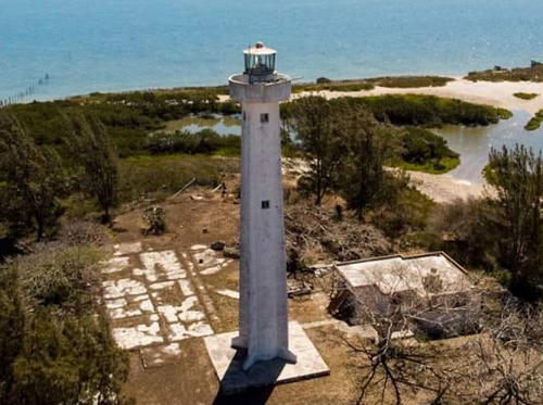
Early 1990s (station established 1904). Active; focal plane 24 m (79 ft); white flash every 6 s. 20 m (66 ft) cylindrical concrete tower with four buttresses, lantern and gallery. Lighthouse painted white; the gallery is blue. Two modern keeper's cottages. A 2019 aerial view is at right, a 2015 photo is available, Alejandro Aguilar has a 2019 photo, and Google has a satellite view. The new light station is located on the mainland about 650 m (0.4 mi) west of the original location. Accessible by 4WD. Site open, tower closed. ARLHS MEX-058; CF-28-100; Admiralty J4232; NGA 15212.
Canal de Chavarria (Barra Morón) (2)
2012. Active; focal plane 10 m (33 ft); white flash every 5 s. 7 m (23 ft) round concrete post with gallery, painted white with blue trim. No photo available but Google has a satellite view. The Admiralty location for this light is incorrect, placing the light on the wrong side of the inlet. Located on the south side of a dredged lagoon entrance at Barra Morón. Accessible only by boat. Site open, tower closed. Active light: CF-28-098; Admiralty J4232.5; NGA 15213.

Punta Jerez Light, Aldama, May 2019
Facebook photo posted by City of Aldama

Altamira Lighthouses
Altamira is a relatively new industrial zone and port constructed on the north side of the Tampico metropolitan area. While the traditional wharves of Tampico continue to handle "loose" cargo, Altamira handles all the containerized shipments for northeastern Mexico.

*
Altamira
1985. Active; focal plane 42 m (138 ft); white flash every 6 s. 37 m (120 ft) octagonal building, with a 3-story base, a central tower, an octagonal harbor control room, and a light tower with lantern and gallery. Building painted white with red (formerly green) trim. Trabas has Capt. Peter's photo (seen at right), César Orta also has a photo, Martín Osuna has a 2022 photo, and Google has a satellite view. The lighthouse includes the headquarters and traffic control center for the port of Altamira. Site open, tower status unknown. Located on the north side of the harbor entrance. Site manager: Puerto de Altamira. ARLHS MEX-097; CF-28-025; Admiralty J4233; NGA 15214.
#Altamira North Range Rear (1)
Date unknown. Removed in 2019-20. This was a 36 m (118 ft) square skeletal tower carrying a rectangular daymark painted red with a white vertical stripe. It has been replaced by a light on a mast (focal plane 16 m (52 ft); white light, 1 s on, 1 s off). The range has been relocated. Trabas has Capt. Peter's photo of the new light and Google has a satellite view. Located on the north side of the dredged harbor of Altamira. Site and tower closed. CF-28-050.1; Admiralty J4233.71.
Altamira Range Rear
Date unknown. Active; focal plane 37 m (121 ft); white light, 1 s on, 1 s off. 36 m (118 ft) square skeletal tower, painted with red and white horizontal bands and carrying a rectangular daymark painted red with a white vertical stripe. Trabas has Capt. Peter's photo and Google has a satellite view. The front light of this range is now on a post and the middle light is on a short skeletal tower. NGA lists the middle light erroneously as the rear light. Located in an oil tank farm about 500 m (0.4 mi) west of the end of the dredged harbor of Altamira. Site and tower closed. CF-28-035.2; Admiralty J4233.42.
Altamira South Range Rear
Date unknown. Active; focal plane 16 m (52 ft); white light, 1 s on, 1 s off. 36 m (118 ft) square skeletal tower carrying a rectangular daymark painted red with a white vertical stripe. Trabas has Capt. Peter's photo and Google has an indistinct satellite view. The front light of this range is on a similar, shorter skeletal tower 11 m (36 ft) tall. Located in a forest on the south side of the dredged harbor of Altamira. Site and tower closed. CF-28-055.1; Admiralty J4233.81.

Altamira Light, Altamira, February 2024
photo copyright Capt. Peter Mosselberger; used by permission

Ciudad Madero Lighthouses
Altamira, Ciudad Madero, Tampico, and Pueblo Viejo are adjoining municipalities, part of the same metropolitan area. Ciudad Madero and Tampico are on the north bank of the Río Pánuco, the border between Tamaulipas and Veracruz states. Pueblo Viejo is on the south bank in Veracruz.

*
Tampico Escollera Norte (North Breakwater)
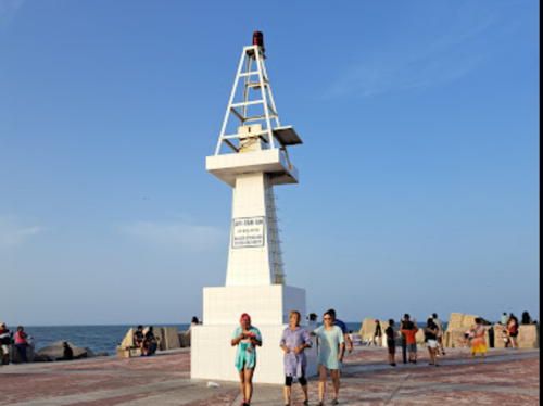
Date unknown. Active; focal plane 10 m (33 ft); red flash every 5 s. 6 m (20 ft) square pyramidal concrete tower, painted white, topped by a square pyramidal skeletal tower. Fernando Martínez's photo is at right, Trabas has Capt. Peter's photo, Ranulfo Martinez has a 2019 photo, Omar Fernando Vilchis Zárate has a street view, and Google has a satellite view. Located at the end of the north breakwater at the entrance to the Río Pánuco and Tampico's traditional harbor. Accessible by walking the breakwater. Site open, tower closed. CF-28-005; Admiralty J4240; NGA 15232.
* Tampico (Faro de la Barra, Ciudad Madero) (2)
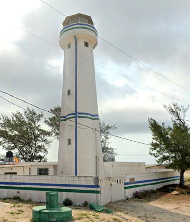
1883 (station established 1865). Active; focal plane 43 m (141 ft); three white flashes every 6 s. 40 m (131 ft) hexagonal pyramidal skeletal tower with central cylinder, lantern and gallery. Entire lighthouse painted white. A 2023 photo by David Sloat is at the top of this page, Emmanual Faz has a good photo, Trabas has Capt. Peter's photo, Huelse has posted a postcard image, and Google has a 2024 street view and a satellite view The lighthouse was designed by U.S. engineers and prefabricated in Pittsburgh. It is the only surviving example of its design. The U.S. Library of Congress has a historic photo of the lighthouse taken before 1897. Locally the lighthouse is also called El Faro de Madero, the name of the seaside city adjacent to Tampico, or El Faro de la Barra, the same name used at Tuxpan (see below) and at many other places in Latin America. Located in an industrial area on the north side of the entrance to the Río Pánuco, about 1200 m (3/4 mi) from the open Gulf of Mexico. Site open, tower closed. ARLHS MEX-033; CF-28-010; Admiralty J4236; NGA 15220.

Escollera Norte Light, Tampico, July 2022
Google Maps photo by Fernando Martínez
Tergosa Range Front
Date unknown. Active (privately maintained); focal plane 16 m (52 ft); white flash every 3 s. 16.5 m (54 ft) square pyramidal skeletal tower with gallery, painted white. Trabas has Capt. Peter's photo and Google has a satellite view. This range guides vessels on the Río Pánuco on the west side of Tampico. Located in an industrial area on the east side of the confluence of the Río Tamesí with the Río Pánuco. Site status unknown. CF-028-615.3.1; Admiralty J4245.5.
Tergosa Range Rear (2)
Date unknown. Active (privately maintained); focal plane 22 m (72 ft); white light, 1 s on, 1 s off. 22 m (72 ft) square pyramidal skeletal tower with gallery, painted white. Trabas has Capt. Peter's photo. and Google has a satellite view. Located in an industrial area on the east side of the confluence of the Río Tamesí with the Río Pánuco, about 180 m (600 ft) west northwest of the front light. Site status unknown. CF-028-615.3; Admiralty J4245.3.
Cemex Range Front (2)
Date unknown. Active (privately maintained); focal plane about 16 m (52 ft); white flash every 3 s. Approx. 12 m (39 ft) square pyramidal skeletal tower with gallery, painted white. Trabas has Capt. Peter's photo and Google has a street view and an indistinct satellite view. Located in the Cemex cement plant west of the Río Tamesí. Site and tower closed. CF-28-615.4; Admiralty J4245.2.
Cemex Range Rear (2)
Date unknown. Active (privately maintained); focal plane about 25 m (82 ft); white light, 1 s on, 1 s off. Approx. 22 m (72 ft) square pyramidal skeletal tower with gallery, painted white. Trabas has Capt. Peter's photo and Google has the street view seen at right and a satellite view. Located in the Cemex cement plant west of the Río Tamesí, about 240 m (800 ft) west of the front light. Site and tower closed. CF-28-615.5; Admiralty J4245.1.

Cemex Range Rear Light, Tampico, June 2024
Google Maps street view

Lighthouses of the Huasteca Region, Veracruz

Huasteca is a cultural region, the traditional home of the Huastec people. It extends from the mountains to the coast and includes southern Tamaulipas. In Veracruz state it is defined to be the portion of the state north of the Río Cazones, which enters the Gulf of Mexico about halfway between Tuxpan and Tecolutla.

Pueblo Viejo Lighthouses
* Canal de Pueblo Viejo Range Rear
Date unknown. Active; focal plane 11 m (36 ft); white light, 1 s on, 1 s off. 9 m (30 ft) square pyramidal white concrete skeletal tower. Trabas has Capt. Peter's photo and Google has the closeup 2024 street view seen at right and a fuzzy satellite view. This is a downstream range guiding vessels leaving Tampico. The front light is on a shorter tower. Located off the Avenida 16 de Septiembre in Pueblo Viejo. Site open, tower closed. CF-28-620.1; Admiralty J4246.1; NGA 15264.1.
* Isla Pérez
Date unknown. Active; focal plane 9 m (30 ft)); white flash every 3 s. 6 m (20 ft) white square pyramidal concrete tower. Trabas has Capt. Peter's photo and Google has a street view and a satellite view. This light guides vessels on a north to south reach in the Río Pánuco. Located near the Calle Principal on the south side of the river. Site open, tower closed. CF-28-625; Admiralty J4245; NGA 15260.
Tampico Arranque Escollera Sur (South Breakwater Root) (2)
Date unknown. Active; focal plane 10 m (33 ft); white flash every 3 s. 7 m (23 ft) white square pyramidal skeletal tower. Trabas has Capt. Peter's photo and Google has a satellite view. Located at the base of the south breakwater at the entrance to the Río Pánuco. Site and tower closed. CF-28-650; Admiralty J4241.4; NGA 15240.

Canal de Pueblo Viejo Range Rear Light, Pueblo Viejo, june 2024
Google Maps street view
Tampico Escollera Sur (South Breakwater) (2)
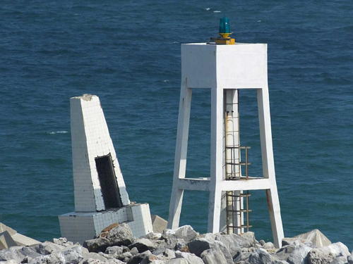
Date unknown (station established 1912). Active; focal plane 10 m (33 ft); green flash every 5 s. 7 m (23 ft) square white concrete skeletal tower with a central post. Trabas has Capt. Peter's closeup photo (seen at right), Rex Castillo Acevedo has a 2025 closeup, and Google has a satellite view and a distant street view from the north breakwater. The original light, a smaller concrete tower, stands askew next to the present light. Located at the end of the south breakwater at the entrance to the Río Pánuco at Tampico (the north side of the river is in Tamaulipas state). Accessible only by boat (the south breakwater is not walkable). Site and tower closed. CF-28-655; Admiralty J4241; NGA 15236.

Laguna de Tamiahua Lighthouses
The Laguna de Tamiahua is large lagoon extending nearly 100 km (60 mi) south from the Tampico area. The lagoon is enclosed by the sandy barrier of Cabo Rojo, which extends like a bent arm into the Gulf of Mexico.

La Rivera (La Ribera)
Date unknown. Active; focal plane 9 m (30 ft); white flash every 3 s. 7.5 m (25 ft) square pyramidal skeletal tower. Alexis Del Angel Reyes has a view from the gallery and Google has an indistinct satellite view and a very distant street view across the lagoon. Located on an islet in the Laguna de Tamiahua off the town of La Rivera, near the northern end of the lagoon. Accessible only by boat. Site open and apparently the tower can be climbed. CF-30-615; Admiralty J4247; NGA 15266.
Punta Bustos
Date unknown. Active; focal plane 6 m (20 ft); white flash every 5 s. 6 m (20 ft) square pyramidal white concrete tower. No photo available but Google has an indistinct satellite view. Located off a headland on the east side of the Laguna de Tamiahua about 11 m (7 mi) south of La Rivera. Accessible only by boat. Site open, tower closed. CF-30-605; Admiralty J4247.6; NGA 15267.1.

Escollera Sur Light, Pueblo Viejo, March 2016
photo copyright Capt. Peter Mosselberger; used by permission
Punta Mangles
Date unknown. Active; focal plane 6 m (20 ft); white flash every 5 s. 6 m (20 ft) square pyramidal white concrete tower. No photo available but Google has an indistinct satellite view. Located off a Ensenada de Mangles, a swampy peninsula projecting from the east side of the Laguna de Tamiahua opposite Las Chacas. Accessible only by boat. Site open, tower closed. CF-30-600; Admiralty J4252.01.
Punta Morales
Date unknown. Active; focal plane 6 m (20 ft); white flash every 5 s. 6 m (20 ft) square pyramidal white concrete tower. No photo available but Google has an indistinct satellite view. Located at the tip of a swampy peninsula projecting from the east side of the Laguna de Tamiahua at the village of Morales. Accessible only by boat. Site open, tower closed. CF-30-595; Admiralty J4252.02.
Martinica (Bajo de Burros)
Date unknown. Active; focal plane 6 m (20 ft); white flash every 3 s. 6 m (20 ft) square pyramidal white concrete tower. on a square concrete pier. No photo available but Google has an indistinct satellite view. This light marks the entrance to the channel for the northern Laguna de Tamiahua. Located in the center of the lagoon east of La Laja. Accessible only by boat. Site open, tower closed. CF-30-575; Admiralty J4252.03.
Guayabalillo
Date unknown. Active; focal plane 6 m (20 ft); white flash every 6 s. 6 m (20 ft) square pyramidal white concrete tower. on a square concrete pier. No photo available but Google has an indistinct satellite view. Located off a swampy peninsula projecting from the east side of the southernmost section of the Laguna de Tamiahua. Accessible only by boat. Site open, tower closed. CF-30-520; Admiralty J4252.16.
 

Cabo Rojo Offshore Lighthouses
Arrecife Blanquilla
Date unknown. Active; focal plane 10 m (33 ft); white flash every 6 s. 9.5 m (31 ft) square cylindrical concrete tower with gallery, painted red and mounted on a square concrete pier. No photo available but Google has a satellite view. Not to be confused with the two Arrecife Blanquilla lights on the Veracruz Reefs (see the Central Gulf Coast page). Located on a reef 12 km (7.5 mi) northeast of the Isla de Lobos lighthouse (next entry). Accessible only by boat. Site open, tower closed. CF-30-480; Admiralty J4249; NGA 15280.
[Arrecife Medio]
Date unknown. Active; focal plane 11 m (36 ft); white flash every 3 s. 11 m (36 ft) post, painted with red and white horizontal bands, on a square concrete pier. No photo available but Google has a satellite view. Located on a reef halfway between the Blanquilla reef and the Isla de Lobos. Accessible only by boat. Site open, tower closed. CF-30-475; Admiralty J4249.5; NGA 15284.
Isla de Lobos (3)
Date unknown (station established 1895). Active; focal plane 32 m (105 ft); white flash every 5 s. 30 m (98 ft) white concrete tower with lantern and gallery. This lighthouse appears to be a sibling of El Palmar, Yucatán. This is a staffed station. José María Espinosa Tapia has the 2021 drone view at right and also a distant drone view, Radio Club Satélite has a photo on a QSL card, Héctor Bohoslavsky has a distant view, and Google has a satellite view. Lighthouse Digest has a historic photo of the 1895 cast iron lighthouse. The lighthouse guides vessels around Cabo Rojo, a very prominent cape in northern Veracruz. The island is located about 15 km (9 mi) southeast of the cape. Accessible only by boat. Site open, tower apparently open with permission of the attendent. ARLHS MEX-035; CF-30-465.1; Admiralty J4250; NGA 15276.

Isla de Lobos Light, Huasteca Alta, April 2021
Google Maps photo by José María Espinosa Tapia

Tuxpan: Reef Lighthouses
Tuxpan (officially Túxpam) is a city of about 80,000 residents at the mouth of the Río Tuxpan. Its port is the closest port to Mexico City, the national capital.

Arrecife Tanguijo (Tanhuijo)
Date unknown. Active; focal plane 11 m (36 ft); three white flashes every 12 s. 10.5 m (35 ft) round concrete tower mounted on a large square concrete base. Entire lighthouse is red. A photo (fourth thumbnail in second row) and a second photo are available and Google has a satellite view. Located on a reef about 25 km (15 mi) north of the Tuxpan entrance. Accessible only by boat. Site open, tower closed. ARLHS MEX-001; CF-30-450; Admiralty J4253; NGA 15288.
[Arrecife Enmedio]
Date unknown. Active; focal plane 10 m (36 ft); two white flashes every 10 s. 10 m (36 ft) post, painted with red and white horizontal bands, on a square concrete pier. A distant 2024 photo is available and Google has a satellite view. Located on a reef halfway between the Tanguijo reef and the Arrecife Tuxpan. Accessible only by boat. Site open, tower closed. CF-30-446; Admiralty J4253.2; NGA 15290.
Arrecife Tuxpan
Date unknown. Active; focal plane 11 m (36 ft); three white flashes every 12 s. 11 m (36 ft) octagonal concrete tower mounted on a large square concrete base. Entire lighthouse is orange. Trabas has Capt. Peter's photo, another photo is available, Ere Rodriguez has a distant 2017 view, and Google has a distant satellite view. Located on a reef about 13 km (8 mi) northeast of the Tuxpan entrance. Accessible only by boat. Site open, tower closed. CF-30-445; Admiralty J4254; NGA 15292.

Tuxpan: Río Tuxpan North Bank Lighthouses
La Barra (Tuxpan, Túxpam, Faro de Recalada) (2)
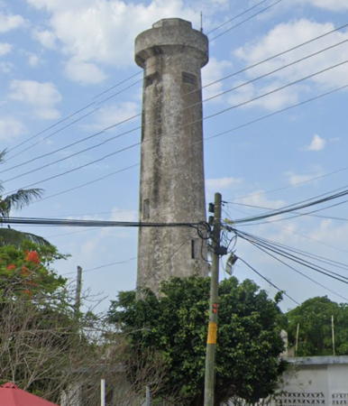
Date unknown (1930s?) (station established 1895). Inactive. Approx. 18 m (59 ft) round unpainted concrete tower. Google's 2023 street view is at right, Capt. Peter contributed a photo, Lighthouse Digest has a historic photo, and Google also has a satellite view. The original lighthouse was a 10 m (33 ft) wood tower. Located on the north side of the entrance to the Río Túxpan in Barra Norte about 200 m (220 yd) south of the modern lighthouse (next entry). Site and tower closed (Mexican Navy property).
* La Barra (Tuxpan, Túxpam, Faro de Recalada) (3)
Date unknown (station established 1895). Active; focal plane 24 m (79 ft); four white flashes every 7 s. 22 m (72 ft) concrete block tower with lantern and double gallery, attached to a 1-story keeper's cottage. Lighthouse painted white; the lantern roof is red. A 2020 photo by Eduardo Pérez is below right, Trabas has Capt. Peter's 2018 photo, and Google has a street view and a satellite view. Located on the north side of the entrance to the Río Túxpan in Barra Norte. Site open, tower closed. ARLHS MEX-136; CF-30-375; Admiralty J4255; NGA 15304.

Second La Barra Light, Tuxpan, May 2023
Google Maps street view
El Cocal (2)
2017. Active; focal plane 34 m (112 ft); red flash every 3 s. Approx. 31 m (102 ft) triangular skeletal tower with gallery, painted red. Trabas has Capt. Peter's 2018 photo and Google has a 2023 street view and a satellite view. Google's 2014 street view shows an earlier, shorter tower. Located on a pier on the north side of the river in downtown Túxpan. Site and tower probably closed. CF-30-416; Admiralty J4258.4.
North Bank Range 1 Front (2)
2018. Active; focal plane about 26 m (85 ft); white light, 1 s on, 1 s off. Approx. 25 m (82 ft) square pyramidal skeletal tower with gallery, painted white. The tower also carries ten daymarks panels colored red with a white vertical stripe. Trabas has Capt. Peter's photo. Google has a street view of the new light and an indistinct satellite view of the original lighthouse. Located on the north bank of the river 250 m (1/8 mi) west of the rear light. Site status unknown. CF-30-405; Admiralty J4259; NGA 15308.
* North Bank Range 1 Rear (2)
2018. Active; focal plane about 35 m (115 ft); white light, 1 s on, 1 s off. Approx. 33 m (105 ft) square pyramidal skeletal tower with gallery, painted white. The tower also carries eleven daymark panels colored red with a white vertical stripe. Trabas has Capt. Peter's photo. Google has a street view of the new tower and an indistinct satellite view. Google's 2012 street view shows the earlier tower. Located on the Carretera Barra Norte about 3 km (2 mi) west of the harbor entrance. Site status unknown, but the tower is easy to see from the street. CF-30-405.1; Admiralty J4259.1; NGA 15312.
* North Bank ex-Range 2 Rear
Date unknown. Inactive. 16 m (52 ft) square pyramidal skeletal tower painted white and carrying a slatted orange daymark. Google has a 2023 street view and an indistinct satellite view. Located near the north bank of the river behind the Hotel Paraíso. Site open, tower closed. ex-CF-30-410.1; ex-Admiralty J4259.21; NGA 15316.1.
* North Bank Range 2 Front (formerly Range 3 Front)
Date unknown. Active; focal plane about 26 m (85 ft); white light, 1 s on, 1 s off. Approx. 25 m (82 ft) square pyramidal skeletal tower with gallery, painted white. The tower also carries ten daymark panels colored red with a white vertical stripe. Trabas has Capt. Peter's photo and Google has a 2023 street view and an indistinct satellite view. Located on the north bank of the river next to the main highway at the western entrance to Túxpan. Site open, tower closed. CF-30-410; Admiralty J4259.24.
* North Bank Range 2 Rear (formerly Range 3 Rear)
Date unknown. Active; focal plane about 35 m (115 ft); white light, 1 s on, 1 s off. Approx. 33 m (105 ft) square pyramidal skeletal tower with gallery, painted white. The tower also carries seven daymark panels colored red with a white vertical stripe. Trabas has Capt. Peter's photo and Google has a 2023 street view and an indistinct satellite view. Located on the north bank of the river next to the main highway at the western entrance to Túxpan. Site open, tower closed. CF-30-410.1; Admiralty J4259.25.

Third (active) La Barra Light, Tuxpan, January 2020
Google Maps photo by Eduardo Pérez

Tuxpan: Río Tuxpan South Bank Lighthouses
* Seminario
Date unknown. Active; focal plane 15 m (49 ft); white flash every 5 s. 13 m (43 ft) triangular skeletal tower painted black and carrying even square red daymarks. Trabas has Capt. Peter's photo and Google has a street view and a satellite view. Located on the south bank of the river off the Carratera Cobos. Site open, tower closed. CF-30-418; Admiralty J4259.32; NGA 15318.
* Cobos (2)
2018. Active; focal plane about 22 m (72 ft); green flash every 3 s. Approx. 20 m (66 ft) triangular skeletal tower painted black and carrying ten red daymark panels. Trabas has Capt. Peter's photo. Google has a closeup 2023 street view of the new light and a satellite view. Google also has a closeup 2012 street view of the original light, which was 12.5 (41 ft) tall. Located on the south bank of the river off the Carratera Cobos. Site open, tower closed. CF-30-417; Admiralty J4259.3; NGA 15317.
Muelle Pemex Range Rear
Date unknown. Active; focal plane about 20 m (66 ft); white light, pattern unknown. Approx. 16 m (52 ft) square white skeletal tower carrying six large red daymarks. A photo contributed by Capt. Peter is at right, Trabas has a version of the same photo, and Google has a satellite view. Located on the south bank of the river just west of the Pemex oil terminal. Site status unknown. CF-30-418.2; Admiralty J4259.296.
* Muelle Pemex Range Front
Date unknown. Active; focal plane about 15 m (49 ft); white light, pattern unknown. Approx. 12 m (39 ft) square white skeletal tower carrying five large red daymarks. Trabas has Capt. Peter's photo and Google has a 2023 street view and a satellite view. Located on the south bank of the river opposite the naval base. Site open, tower closed. CF-30-418.1; Admiralty J4259.2905.

Muelle Pmex Range Rear Light, Tuxpan, September 2018
photo copyright Capt. Peter Mossellberger; used by permission
* Tuxpan Range 3 Rear (formerly Etileno Range Rear) (2)
Date unknown. Active; focal plane about 35 m (115 ft); white light, 1 s on, 1 s off. Approx. 33 m (105 ft) square pyramidal skeletal tower with gallery, painted white. The tower also carries eleven daymark panels colored red with a white vertical stripe. Trabas has Capt. Peter's photo and Google has a 2023 street view seen at right and a satellite view. Located on the south bank of the river opposite the naval base. Site open, tower closed. CF-30-415.1; Admiralty J4259.291.
* Tuxpan Range 3 Front (formerly Etileno Range Front) (2)
Date unknown. Active; focal plane about 26 m (85 ft); white light, 1 s on, s off. Approx. 25 m (82 ft) square pyramidal skeletal tower with gallery, painted white. The tower also carries seven daymark panels colored red with a white vertical stripe. Trabas has Capt. Peter's photo and Google has the 2023 street view seen at right and a satellite view. Located on the south bank of the river opposite the naval base. Site open, tower closed. CF-30-415; Admiralty J4259.29.
Tuxpan Entrance Range Front (1 and 2)
2017. Active; focal plane 22 m (72 ft); white flash every 3 s. 22 m (72 ft) triangular skeletal tower with gallery, painted white. The tower also carries ten daymark panels colored red with a white vertical stripe. Trabas has Capt. Peter's photo; it also shows the older tower, which was still standing as of 2023. Google has a satellite view and a distant 2023 street view from across the river showing the old and new towers. Located on the south side of the Río Túxpan in La Moderna. Site status unknown. CF-30-400; Admiralty J4258; NGA 15305.
Tuxpan Entrance Range Rear (1 and 2)
2017. Active; focal plane 28 m (92 ft); white light, 1 s on, 1 s off. 28 m (92 ft) triangular skeletal tower with gallery, painted white. The tower also carries seven daymark panels colored red with a white vertical stripe. Trabas has Capt. Peter's photo and Google has a satellite view. and a distant street view across the river showing the new tower on the right and the old one on the left. Located 270 m (885 ft) west southwest of the front light. Site status unknown. CF-30-400.1; Admiralty J4258.1; NGA 15306.

Range 3 (Etileno) Range Rear Light, Tuxpan, May 2023
Google Maps street view

Information available on lost lighthouses

Notable faux lighthouses:

Adjoining pages: North: South Texas | South: Central Gulf Coast

Return to the Lighthouse Directory index | Ratings key

Posted December 2004. Checked and revised April 1, 2025. Lighthouses: 51. Site copyright 2025 Russ Rowlett and the University of North Carolina at Chapel Hill.