Lighthouses of the United States: South and Central Texas

The United States of America is a federal union of 50 states and a capital district. Texas is the second-largest U.S. state (after Alaska) but its long coast on the Gulf of Mexico is relatively featureless and has never required very many coastal lighthouses. And unfortunately the number of historic Texas lighthouses has fallen from 7 to 5 since 2000. In May 2000 the Galveston Jetty Light collapsed into the Gulf during a severe thunderstorm and in early 2002 the Coast Guard demolished the Sabine Bank Light.

The first European settlements in Texas were made by Spain in the early 1700s. Texas continued as a Spanish colony and then as a part of Mexico after Mexico won its independence from Spain in 1821. In 1836 Americn settlers in Texas declared their independence and succeeded in defeating a Mexican army that sought to retake the territory. Texas was then governed as an independent republic until it was admitted to the United States as the 28th state in 1845.

Navigational aids in South Texas are operated by the U.S. Coast Guard Sector Corpus Christi with Aids to Navigation Teams at Corpus Christi, Port O'Conner, and South Padre Island. Ownership (and sometimes operation) of historic lighthouses has been transferred to local authorities and preservation organizations in many cases.

ARLHS numbers are from the ARLHS World List of Lights. Admiralty numbers are from volume J of the Admiralty List of Lights & Fog Signals. USCG numbers are from Volume IV of the U.S. Coast Guard Light List.

General Sources
Texas Lighthouses
Fine photos and historical accounts by Kraig Anderson.
Online List of Lights - Texas
Photos posted by Alexander Trabas. Many photos for South Texas were taken by Capt. Peter Mosselberger ("Capt. Peter") or Capt. Theo Hinrichs ("Capt. Theo").
Lighthouses in Texas
Photos by various photographers available from Wikimedia.
World of Lighthouses - Gulf Coast of U.S.
Photos by various photographers available from Lightphotos.net.
Sentinels of the Sea
A 2017 article in Texas Highways magazine describes the state's historic lighthouses.
Leuchttürme auf der USA auf historischen Postkarten
Historic postcard views posted by Klaus Huelse.
U.S. Coast Guard Navigation Center: Light Lists
The USCG Light List can be downloaded in pdf format.
NOAA Nautical Charts
Nautical charts for the coast can be viewed online.
GPSNautical Charts
Navigation chart for Texas.


Port Isabel Light, Port Isabel, March 2024
Instagram photo by Port Isabel Lighthouse S.H.S.
South Texas Lighthouses

Calhoun County (Matagorda Bay Area) Lighthouses
Matagorda Bay is a large estuarine lagoon roughly 80 mi (130 km) northeast of Corpus Christi. Port O'Connor and Port Lavaca are seaports on the bay.

Matagorda Ship Channel Entrance (2)
Around 2022. Active; focal plane 64 ft (19.5 m); white flash every 10 s. This tower also carries the rear light of the outbound exit range (Range B) (white light occulting once every 4 s, at focal plane 62 ft (19 m)) and also a passing light (red flash every 4 s at focal plane 23 ft (7 m)). 64 ft (19.5 m) square cylindrical skeletal tower with gallery. The tower carries a rectangular daymark colored red with a white vertical stripe. Google has a satellite view. Trabas has Capt. Peter's photo of the earlier pyramidal tower; it is seen in Bing's satellite view. The front light is on a short skeletal tower. Located on the north jetty at the entrance to the Matagorda Ship Channel, a cut made through the barrier about 3 miles (5 km) east of Port O'Connor and a similar distance northeast of the natural Matagorda Inlet. Accessible only by boat. Site open, tower closed. Admiralty J4193.1; USCG 4-1385 (=27110) (entrance light) and 4-27180 (range light).
Matagorda Ship Channel Entrance Range (Range A) Rear
Date unknown. Active; focal plane 78 ft (24 m); white light, 3 s on, 3 s off; there's also a passing light showing a white flash every 4 s at focal plane 21 ft (6.5 m). 78 ft (24 m) square skeletal tower with gallery, mounted on a rectangular (double square) platform supported by piles. Trabas has Capt. Peter's photo and Google has a satellite view. The front light is on a post. Located in Matagorda Bay, east of the ship channel and about 2.5 miles (4 km) northwest of the entrance. Accessible only by boat. Site open, tower closed. Admiralty J4192.1; USCG 4-27125.
Point Comfort Channel Range E Rear
Date unknown. Active; focal plane 66 ft (20 m); red light occulting once every 4 s, visible only on the range line; there's also a passing light showing a white flash every 4 s at focal plane 17 ft (5 m). 60 ft (18 m) square skeletal tower with gallery, mounted on a square platform supported by piles. Trabas has Capt. Peter's very distant view of both range lights and Google has a satellite view. This is the inbound range for ships arriving at Point Comfort, on the north shore of Matagorda Bay. Located near the waterfront in an indistrial area of Point Comfort. Accessible only by boat. Site open, tower closed. Admiralty J4195.59; USCG 4-27495.
Matagorda Ship Channel Range C Rear
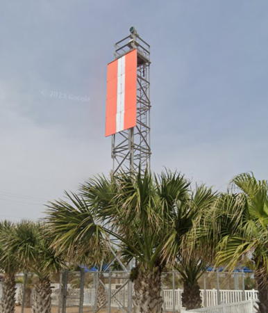
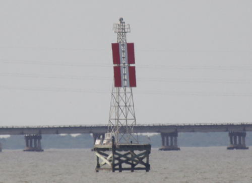
Date unknown. Active; focal plane 60 ft (18 m); white light occulting once every 4 s, visible only on the range line; there's also a passing light showing a white flash every 4 s at focal plane 15 ft (4.5 m). 60 ft (18 m) square skeletal tower with gallery, mounted on a square platform supported by piles. Trabas has Capt. Peter's photo (also seen at right) and Google has a satellite view. The front light is on a short tower. Located in the northwestern corner of Matagorda Bay about 2 miles (3 km) east of the Port Lavaca waterfront. Accessible only by boat. Site open, tower closed. Admiralty J4195.03; USCG 4-27345.

Matagorda Ship Channel Range C Rear Light, Matagorda Bay
photo copyright Capt. Peter Mosselberger; used by permission
Point Comfort Channel Range D Rear
Date unknown. Active; focal plane 47 ft (14.5 m); green light occulting once every 4 s, visible only on the range line; there's also a passing light showing a white flash every 4 s at focal plane 18 ft (5.5 m). 47 ft (14.5 m) square skeletal tower with gallery, mounted on a square platform supported by piles. Trabas has Capt. Peter's distant view and Google has a satellite view. This is the outbound range for ships leaving Point Comfort, on the north shore of Matagorda Bay. The front light is on a short tower. Located off Gallinipper Point in the northwestern corner of Matagorda Bay about 2 miles (3 km) east of the Port Lavaca waterfront. Accessible only by boat. Site open, tower closed. Admiralty J4195.63; USCG 4-27520.
*** Halfmoon Reef
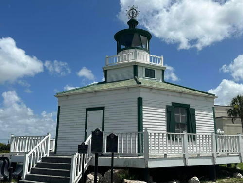
1858 (Walter H. Stevens). Inactive since 1942 (a decorative flashing light is displayed). 6 m (20 ft) hexagonal wood keeper's house surmounted by a hexagonal cylindrical tower with lantern and gallery. Lighthouse painted white with green trim. Coral Dworaczyk Carey's 2023 photo is at right, Chris Foster has a 2021 photo, Zanna McNeil has a 2018 photo, and Google has a street view and a satellite view. This lighthouse was originally located on a screwpile platform off Palacios Point in the central part of Matagorda Bay; the Coast Guard has a historic photo. The lighthouse was deactivated, sold, and relocated onshore following a 1942 hurricane. In 1978 it was donated by its owner, Bill Bauer, to the Calhoun County Historical Commission. Bauer also endowed a trust fund for future maintenance. The lighthouse was then relocated a second time to the Port Lavaca Community Park in Port Lavaca, at the west end of the bay, where it is in service as the Port Lavaca Visitors Center. The building was renovated in the spring of 2016, reopening in August. Located at the intersection of TX 35 and TX 238 at the northeastern entrance to Port Lavaca. Site and lighthouse open daily. Owner/site manager: Calhoun County Historical Commission. . ARLHS USA-363.

Halfmoon Reef Light, Port Lavaca, July 2023
Instagram photo by Coral Dworaczyk Carey
Matagorda
1852 (relocated inland 1873) (Hiram G. Runnels). Reactivated (inactive 1995-1999, now privately maintained); focal plane 90 ft (27.5 m); white flash every 3 s. 79 ft (24 m) tapered cast iron tower, painted black, solar-powered 250 mm lens. The original 3rd order Fresnel lens is on display at the Calhoun County Museum in Port Lavaca. The keeper's house and all other light station buildings have been demolished. A 2023 closeup is at right, Steve Franz has a 2020 photo, Fred Lanoue has Ron Smudy's 2015 photo, Mauricio de la Torre has a drone view, the Coast Guard has a historic photo of the light station, and Google has a satellite view. This is the first lighthouse built in Texas. Originally a sibling of the Pass a l'Outre Light in Louisiana, the tower was raised from 65 ft (20 m) to 79 ft (24 m) when it was relocated, giving it an unusual tapered profile. The Matagorda Island Foundation raised over $1 million as a Millennium project to preserve the lighthouse and the beacon was relit on New Year's Eve 1999. After three more years of work the restored lighthouse was rededicated on 11 June 2004. However, there is now reason for concern about the lighthouse. In later phases of the project the keeper's house was to be rebuilt and a visitor center built at the state park dock. These improvements have not been made. In 2014 there were discussions about plans for further restoration but nothing has been done. The 2020 photo by Franz and the 2023 closeup at right show the tower rusting and in need of repainting, at least. The lighthouse is located in the Matagorda Island Wildlife Management Area. There is no regular ferry service, but several shuttle services are available. Located near the northeast end of Matagorda Island, opposite Port O'Connor. Site open, tower closed. Owner/site manager: U.S. Fish and Wildlife Service (leased to Calhoun County). . ARLHS USA-482; Admiralty J4193.2; USCG 4-1395.

Aransas County Lighthouses
Aransas Bay is an estuarine lagoon about 30 miles (50 km) northeast of Corpus Christi. Aransas Pass connects the bay to the Gulf of Mexico and is also the principal entrance to the important port of Corpus Christi.

***
Texas Maritime Museum (Rockport)
2003. Active (privately maintained); focal plane 43 ft (13 m); quick-flashing white light. 48 ft (14.5 m) square tower with a broad observation gallery, pyramidal roof, and a small lantern at the peak. The tower is painted black with a white trapezoidal daymark on the front face; observation room painted white; roof is red. Cara McGowin has a 2019 photo and Google has a street view and a satellite view. An addition to the museum built in 2003, the building houses exhibits related to Texas lighthouses. Located at 1202 Navigation Circle on the waterfront at Rockport, on the west side of Aransas Bay. Site open; museum and tower open daily except Mondays (admission fee). Owner/site manager: Texas Maritime Museum. ARLHS USA-1247; USCG 4-39010.

Matagorda Light, Calhoun County, May 2023
Instagram photo by Rowdy Fisherman
Corpus Christi Cut A Outbound Range Rear
Date unknown. Active; focal plane 78 ft (24 m); white light, 3 s on, 3 s off, visible only on the range line. Approx. 72 ft (22 m) square skeletal tower mounted on a concrete base. The tower carries a rectangular daymark colored red with a white vertical stripe. Trabas has Capt. Peter's photo and Google has a satellite view. The front light is on a smaller skeletal tower. The Corpus Christi Cut is a dredged channel about 20 miles (32 km) long connecting Corpus Christi Bay to Aransas Pass. Located in dunes about 0.6 mi (1 km) north of the pass. Site open, tower closed. ARLHS USA-1366; Admiralty J4213.26; USCG 4-28310.
 
Lydia Ann Channel (Aransas Pass)
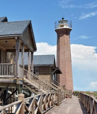
1857 (Walter H. Stevens). Reactivated (inactive 1952-1988; now privately maintained); focal plane 65 ft (20 m); continuous white light. 68 ft (21 m) octagonal red brick tower. Lantern painted white. The original 4th order Fresnel lens is on display at the Port Aransas Museum. The lighthouse is a sibling of the Sabine Pass (Louisiana) Light, but without the buttresses added to that lighthouse. The 1-story frame keeper's quarters (1919) is occupied by resident keepers. A portion of Andy Staver's 2019 photo is seen at right, Jim Howard has a photo, Kimberly Lavoie has a 2016 photo, Trabas has a photo, and Google has a satellite view. The light station was restored by its former owner Charles Butt, owner of the HEB grocery chain; it remains in private ownership. The keepers light the lens each night. Located adjacent to the Lydia Ann Channel on the north side of Aransas Pass in San Patricio County. Accessible only by boat. Site and tower closed. Owner/site manager: private. . ARLHS USA-018; Admiralty J4216.49 (ex-J4212); USCG 4-39720.

Eastern Nueces County (Port Aransas Area) Lighthouses
Harbor Island Range Front
Date unknown. Active; focal plane 67 ft (20 m); green (night) or white (day) light, 1 s on, 1 s off, visible only on the range line. Approx. 62 ft (19 m) square skeletal tower. Trabas has Capt. Theo's photo and Google has a satellite view. The range guides vessels through the dredged cut that has replaced Aransas Pass for commercial traffic. Located about 1.75 miles (3 km) southwest of the historic lighthouse. Site status unknown. ARLHS USA-1367; Admiralty J4213; USCG 4-28145.
Harbor Island Range Rear
Date unknown. Active; focal plane 121 ft (37 m); continuous green (night) or white (day) light visible only on the range line. Approx. 115 ft (35 m) triangular skeletal tower. Trabas has Capt. Theo's photo and Google has a satellite view. Located 0.85 mi (1.37 km) northwest of the front light. Site status unknown. ARLHS USA-1368; Admiralty J4213.1; USCG 4-28150.
Corpus Christi Cut B Outbound Range Rear
Date unknown. Active; focal plane 128 ft (39 m); white light, 3 s on, 3 s off, visible only on the range line; there's also a quick-flashing yellow passing light at a focal plane of 36 ft (11 m). 128 ft (39 m) square skeletal tower mounted on a square platform supported by piles. Trabas has Capt. Theo's photo and Google has a satellite view. The front light is on a tall post. Located in Corpus Christi Bay off the south side of an island southeast of Ingleside. Accessible only by boat. Site open, tower closed. ARLHS USA-1363; Admiralty J4214.41; USCG 4-28710.

Lydia Ann Channel Light, Aransas Pass, August 2019
Google Maps photo by Andy Staver
La Quinta Outbound Range Rear
Date unknown. Active; focal plane 55 ft (17 m); white light, 3 s on, 3 s off, visible only on the range line. 55 ft (17 m) square skeletal tower mounted on a square platform supported by piles. The tower carries a rectangular daymark colored red with a white vertical stripe. Trabas has Capt. Theo's photo and Google has a satellite view. The front light is on a short skeletal tower. Located in Corpus Christi Bay off the south side of an island southeast of Ingleside. Accessible only by boat. Site open, tower closed. ARLHS USA-1370; Admiralty J4216.91; USCG 4-28965.
Corpus Christi Cut A Inbound Range Rear
Date unknown. Active; focal plane 78 ft (24 m); white light, 3 s on, 3 s off, visible only on the range line. Approx. 65 ft (20 m) square skeletal tower mounted on a square platform supported by piles. The tower carries a rectangular daymark colored red with a white vertical stripe. Trabas has Capt. Theo's photo and Google has a satellite view. The front light is on a short skeletal tower. Located in Corpus Christi Bay about 3 miles (5 km) southwest of Ingleside. Accessible only by boat. Site open, tower closed. ARLHS USA-1362; Admiralty J4214.31; USCG 4-28625.

San Patricio County Lighthouse
La Quinta Inbound Range Rear
Date unknown. Active; focal plane 64 ft (19.5 m); green light, 3 s on, 3 s off, visible only on the range line. Approx. 59 ft (18 m) square skeletal tower carryings a rectangular daymark colored red with a white vertical stripe. Trabas has Capt. Peter's distant view and Google has a satellite view. The front light is on a short skeletal tower. Located in an industrial area at the northernmost extension of Corpus Christi Bay. Site and tower closed. ARLHS USA-1369; Admiralty J4216.96; USCG 4-28975.

Corpus Christi City Lighthouses
Corpus Christi is a city of more than 325,000 residents. It is a major seaport on the inner side of Corpus Christi Bay, an estuarine lagoon separated from the Gulf of Mexico by Mustang Island. The dredged ship channel crosses the mostly shallow bay from east to west.
* Corpus Christi Cut B Inbound Range Front
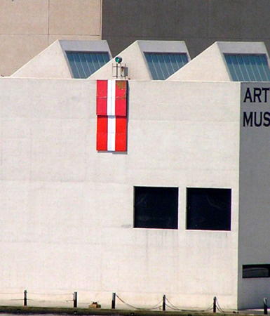
Date unknown. Active; focal plane 55 ft (17 m); green light occulting once every 4 s, visible only on the range line. This light is mounted on the front of the Art Museum of South Texas. Below the light is a rectangular daymark colored red with a white vertical stripe. Trabas has Capt. Peter's photo and Google has a street view and a satellite view. Capt. Theo contributed a photo showing both range lights. Located on the Corpus Christi waterfront on the south side of the entrance to the inner harbor channel. Site open, tower closed. Owner/site manager: Art Museum of South Texas. ARLHS USA-1364; Admiralty J4215.25; USCG 4-28770.
Corpus Christi Cut B Inbound Range Rear
Date unknown. Active; focal plane 101 ft (31 m); continuous green light visible only on the range line. 101 ft (31 m) square skeletal high-voltage transmission tower, painted white. The tower carries a rectangular daymark colored red with a white vertical stripe. Trabas has Capt. Theo's photo and Capt. Theo also contributed a photo showing both range lights. Google has a street view and a satellite view. Located in an industrial area on the south side of the inner harbor channel in Corpus Christi. Site and tower closed. ARLHS USA-1365; Admiralty J4215.26; USCG 4-28775.
Industrial Canal Inbound Range Rear
Date unknown. Active; focal plane 65 ft (20 m); continuous green light. Approx. 62 ft (19 m) square skeletal tower carrying a rectangular daymark colored red with a white vertical stripe. Trabas has a photo and Google has a street view and an indistinct satellite view. The front light is on a 14 m (46 ft) skeletal tower. The Corpus Christi Industrial Canal is a channel with several turning basins; about 4 mi (6.4 km) long, it parallels the south shore of Nueces Bay, a northwestern extension of Corpus Christi Bay. Located at the west end of Avery Point Turning Basin on the south side of the Canal. Site and tower closed. Admiralty J4215.51; USCG 4-28830.
Tule Lake Channel Inbound Range A Rear
Date unknown. Active; focal plane 63 ft (19.5 m); continuous green light. Approx. 59 ft (18 m) square skeletal tower carrying a rectangular daymark colored red with a white vertical stripe. Trabas has a photo and Google has a satellite view and a distant street view. The front light is on a 14 m (46 ft) skeletal tower. Located on the north side of the Canal, north of Navigation Boulevard and opposite the Industrial Canal Inbound Range Light. Site status unknown. Admiralty J4215.56; USCG 4-28840.
Tule Lake Channel Directional
Date unknown. Active; focal plane 143 ft (44 m); continuous or flashing light, white, red or green depending on direction. Approx. 138 ft (42 m) triangular skeletal tower. Google has a satellite view and a distant street view. The light guides ships through a narrow section of the Canal. This is apparently a new tower, only recently listed by the Admiralty. Located on the south side of the Canal at the start of the Tule Lake section. Site and tower closed. Admiralty J4215.7; USCG 4-28872.

Corpus Christi Cut B Ibound Range Front Light, Corpus Christi
photo copyright Capt. Peter Mosselberger; used by permission
Tule Lake Channel Outbound Range F Rear
Date unknown. Active; focal plane 80 ft (24.5 m); green light, 3 s on, 3 s off, intensified on the range line. Approx. 75 ft (23 m) square skeletal tower carrying a rectangular daymark colored red with a white vertical stripe. Trabas has a photo and Google has a street view and a satellite view. Located next to the Interstate Grain Corporation at 5700 Up River Road on the south side of the Canal. Site status unknown. Admiralty J4215.96; USCG 4-28890.
Tule Lake Channel Outbound Range F Front
Date unknown. Active; focal plane 55 ft (17 m); quick-flashing green light. Approx. 52 ft (16 m) square skeletal tower carrying a rectangular daymark colored red with a white vertical stripe. Trabas has a photo and Google has a satellite view. Located on the south side of the channel at the Valero facility 646 yd (591 m) west northwest of the rear light. Site and tower closed. Admiralty J4215.95; USCG 4-28885.
Tule Lake Channel Inbound Range B Front
Date unknown. Active; focal plane 55 ft (17 m); quick-flashing green light, intensified on the range line. 55 ft (17 m) square skeletal tower carrying a rectangular daymark colored red with a white vertical stripe and mounted on a platform supported by piles. Trabas has a photo and Google has an indistinct satellite view. Located on the south side of the Canal at a Valero Oil tank farm. Site and tower closed. Admiralty J4215.75; USCG 4-28850.
Tule Lake Channel Inbound Range B Rear
Date unknown. Active; focal plane 75 ft (23 m); green light, 3 s on, 3 s off, intensified on the range line. Approx. 72 ft (22 m) square skeletal tower carrying a rectangular daymark colored red with a white vertical stripe. Trabas has a photo and Google has a satellite view. Located in a Valero Oil tank farm on the south side of the Canal, 651 yd (595 m) west of the front light. Site and tower closed. Admiralty J4215.76; USCG 4-28855.

Tule Lake Channel Outbound Range F Rear Light, Corpus Christi, May 2016
Google Maps street view

Willacy County Lighthouse
* Port Mansfield Range Rear
Date unknown. Active; focal plane 77 m (23.5 m); red light occulting once every 4 s, visible only on the range line. Approx. 72 ft (22 m) square skeletal tower mounted on a square concrete base. The tower carries a rectangular daymark colored red with a white vertical stripe. Google has a street view and a satellite view. The front light is on a 20 ft (6 m) skeletal tower just offshore. tower. Port Mansfield is a fishing port on the west side of Laguna Madre, connected to the Gulf of Mexico by an artificial cut through the South Padre Island barrier beach. Located one block west off Red Fish Bay Road (TX 186) at Beacon Street in Port Mansfield. Site open, tower closed. ARLHS-1401; USCG 4-29420.

Cameron County (Brownsville Area) Lighthouses
Brownsville is a city of nearly 200,000 residents facing the Mexican city of Matamoros across the lower Rio Grande. The mouth of the river is not navigable but the city is connected to the Gulf of Mexico at the Brazos Santiago Pass by the Brownsville Ship Channel, a dredged canal with a depth of 16 m (52 ft).
**** Port Isabel (Point Isabel)
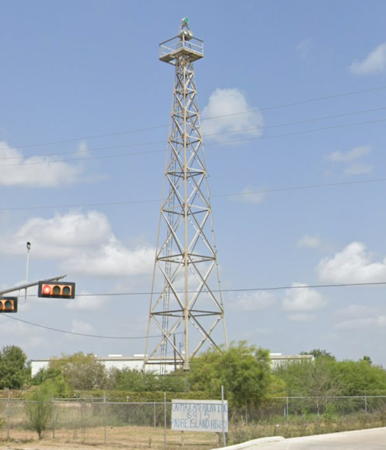
1853 (John E. Garrey). Reactivated (inactive 1905-2018, now privately maintained and unofficial, though charted as a lighthouse); focal plane 91 ft (28 m); continuous white light. 57 ft (17 m) brick tower, painted white; lantern and gallery black. A replica of the 1-story frame 1855 keeper's quarters (1995) houses a small museum and the city's visitor center. A 2024 photo is at the top of this page, the Bailey Family has a 2021 photo, Larry Weiss has a fine photo, Trabas has Michael Boucher's photo, Huelse has a historic postcard view, and Google has a street view and a satellite view. The lighthouse reopened in late July 2000 following a major restoration. In 2014 the buildings were repainted and the stairs of the lighthouse repaired. The lighthouse was closed to climbing in October 2016 for restoration and repairs. Various problems caused the planned four-month restoration to extend more than a year, but the work was completed by the end of 2017 and the lighthouse reopened on 2 January 2018. In September 2019 control of the light station was transferred from Texas Parks and Wildlife to the Texas Historical Commission. In 2022 a replica 3rd order Fresnel lens was installed and a lighting ceremony held on December 9. Located on TX 100 at Tarnava Street in Port Isabel, at the west end of the bridge to Padre Island. Site open, visitor center (free) open daily except Sundays, tower (admission fee) open daily. Owner: Texas Historical Commission (Port Isabel Lighthouse State Historic Site ). Site manager: Museums of Port Isabel. ARLHS USA-649; Admiralty J4228.6.
* Laguna Madre Range Rear (2)
Date unknown. Active; focal plane 67 ft (20 m); green light, 3 s on, 3 s off, visible only on the range line. 62 ft (19 m) square skeletal tower mounted on a square platform supported by piles. The tower carries a rectangular daymark colored red with a white vertical stripe. Google has the street view seen at right and a satellite view. Trabas has Capt. Peter's photo of the earlier version of the light. This light is close to the location of the historic Brazos Santiago Light. The front light is on a shorter skeletal tower just offshore. The range guides outbound vessels toward the Brazos Santiago Pass. Located off Channel View Road near the southern tip of South Padre Island. Site open, tower closed. ARLHS USA-1323; Admiralty J4226.56; USCG 4-29560.
Brazos Santiago Entrance Range Rear
Date unknown. Active; focal plane 72 ft (22 m); green light, 3 s on, 3 s off, visible only on the range line. 72 ft (22 m) square skeletal tower mounted on a square platform supported by piles. The tower carries a rectangular daymark colored red with a white vertical stripe. Trabas has Capt. Peter's photo and Google has a satellite view. The front light is on a shorter skeletal tower. Located in the sound about 1.75 mi (3 km) east southeast of Port Isabel. Accessible only by boat. Site open, tower closed. ARLHS-1405; Admiralty J4226.51; USCG 4-29470.

Laguna Madre Range Rear Light, South Padre Island,March 2023
Google Maps street view
Brownsville Channel Outbound Range C Rear
Date unknown. Active; focal plane 65 ft (20 m); green light, 3 s on, 3 s off, visible only on the range line. 62 ft (19 m) square skeletal tower. The tower carries a rectangular daymark colored red with a white vertical stripe. Trabas has Capt. Peter's photo and Google has a satellite view. The Brownsville Channel is a canal 17 mi (27 km) long linking the city of Brownsville to Brazos Santiago Pass. The canal serves ocean-going ships, and it is also the southernmost channel of the Gulf Intracoastal Waterway. The range guides vessels leaving Brownsville. The front light is on a short skeletal tower. Located on the south side of the channel near the east end. Site open, tower closed. ARLHS USA-1376; Admiralty J4226.91; USCG 4-29865.
Brownsville Channel Outbound Range E Rear
Date unknown. Active; focal plane 63 ft (19.5 m); green light, 3 s on, 3 s off, visible only on the range line. 60 ft (18 m) square skeletal tower mounted on a square platform supported by piles. The tower carries a rectangular daymark colored red with a white vertical stripe. Trabas has Capt. Peter's photo (also seen at right) and Google has a satellite view. This range also guides vessels leaving Brownsville. The front light is on a short skeletal tower. Located on the north side of the channel opposite the Range A Rear Light (next entry). Site open, tower closed. ARLHS USA-1378; Admiralty J4227.11; USCG 4-29905.
Brownsville Channel Inbound Range A Rear
Date unknown. Active; focal plane 60 ft (18 m); green light, 3 s on, 3 s off, visible only on the range line. 57 ft (17.5 m) square skeletal tower. The tower carries a rectangular daymark colored red with a white vertical stripe. Trabas has Capt. Peter's photo and Google has a satellite view. This is the entrance range for vessels approaching Brownsville. The front light is on a shorter skeletal tower. Located on the south side of the channel about 1/4 the way down. Site open, tower closed. ARLHS USA-1374; Admiralty J4226.96; USCG 4-29875.
Brownsville Channel Inbound Range B Rear
Date unknown. Active; focal plane 75 ft (23 m); green light, 3 s on, 3 s off, visible only on the range line. 72 ft (22 m) square skeletal tower. The tower carries a rectangular daymark colored red with a white vertical stripe. Trabas has Capt. Peter's photo and Google has a satellite view and a very distant street view. This range guides vessels approaching Brownsville. The front light is on a shorter skeletal tower. Located on the north side of the channel near the middle. Site open, tower closed. ARLHS USA-1375; Admiralty J4227.21; USCG 4-29930.
Brownsville Channel Outbound Range G Rear
Date unknown. Active; focal plane 58 ft (17.5 m); green light, 3 s on, 3 s off, visible only on the range line. 55 ft (16.5 m) (?) square skeletal tower. The tower carries a rectangular daymark colored red with a white vertical stripe. Trabas has Capt. Peter's photo, and Google has a satellite view and a very distant street view. This range guides vessels leaving Brownsville. The tower appears taller in the photo than its listed height. The front light is on a short skeletal tower. Located beside a service road on the south side of the channel about 2/3 of the way from the entrance. Site open, tower closed. ARLHS USA-1381; Admiralty J4227.41; USCG 4-29970.
Brownsville Channel Inbound Range D Rear
Date unknown. Active; focal plane 67 ft (20 m); white light, 3 s on, 3 s off. 64 ft (19.5 m) (?) square skeletal tower. The tower carries a rectangular daymark colored red with a white vertical stripe. Trabas has Capt. Peter's photo and Google has a satellite view. The front light is on a shorter skeletal tower. Located on the south side of the channel a short distance west of the fishing harbor. Site open, tower closed. ARLHS USA-1377; Admiralty J4227.51; USCG 4-29955.
Brownsville Channel Inbound Range F Rear
Date unknown. Active; focal plane 98 ft (30 m); green light during the night and white light during the day, occulting once every 4 s, visible only on the range line. 64 ft (19.5 m) (?) square skeletal tower. The tower carries a rectangular daymark colored red with a white vertical stripe. Trabas has Michael Boucher's closeup photo and Google has the street view at right and a satellite view. This is the terminal range for vessels arriving in Brownsville. The front light is on a short skeletal tower. Located beside the South Padre Island Highway (TX 48) at Coffee Port Road on the east side of Brownsville. Site open, tower closed. ARLHS USA-1380; Admiralty J4228.06; USCG 4-29995.

Inbound Range F Rear Light, Brownsville, July 2023
Google Maps street view

Central Texas Lighthouses

Comal County Lighthouse
* Lake Canyon Yacht Club
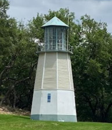
1985. Active; white light, characteristics unknown. Approx. 25 ft (7.5 m) octagonal wooden tower with lantern, painted white; lantern is turquoise. Carolina Velasco Rojas has the 2022 photo at right and Google has a satellite view. This was originally a faux lighthouse built as part of the Boston Sea Party restaurant in San Antonio. When the restaurant was demolished in 1985 the lighthouse was donated to the club and relocated. The base of the tower includes a room used for hearing race protests. Located on a bluff above the docks of the yacht club, off Mt. Lookout Drive on the north shore of Canyon Lake in Comal County, about 45 mi (72 km) north of San Antonio. Site open, tower closed. Owner/site manager: Lake Canyon Yacht Club.

Llano County Lighthouses
* Horseshoe Bay (Lake Lyndon B. Johnson)
1972. Active, charted by Navionics; white light, characteristics unknown. 55 ft (17 m) square tower with a large observation room; the navigation beacon is on the roof. Venkata Raghavendhra Chowdary Maddhipatla has a 2020 photo, Rubi Bothwell has a 2018 photo, M.S. Zakeer has a closeup, George Williamson has an aerial view, and Google has a satellite view. The tower also includes chimes that announce the hours and are also played on special occasions. In 2014 a fund drive was underway to raise $80-100,000 to refurbish the lighthouse. In 2015 a complete renovation of the lighthouse, including siding, roof, interior and exterior lighting, and a new entrance gate, was completed at a cost of over $105,000. Located at the end of Lighthouse Drive and of a long dike extending into Lake Lyndon B. Johnson at Horseshoe Bay in Llano County, about 45 mi (72 km) northwest of Austin. Accessible by walking the dike (the entry is gated but visitors on foot are not excluded). Site open, tower status unknown. Owner: Horseshoe Bay Property Owners Association. Site manager: Friends of the Horseshoe Bay Lighthouse. .
Lake Buchanan
1984. Reactivated (inactive ca. 1990-2006; charted by Navionics); focal plane 140 ft (42.5 m); rotating white light. 110 ft (33.5 m) square concrete tower with gallery, topped by a large square observation room. The lighthouse is actually painted in a red and white checkerboard pattern, but from each side it appears to have red and white horizontal bands. A 2009 photo iand a good 2008 photo are available, and Google has a street view and a satellite view. Built privately by Raymond Barker, this lighthouse was repossessed by a bank in 1990 and deteriorated for years. In 2006 it was purchased by Harold Riley of Austin, owner of the Citizens Insurance Company. Riley restored and reactivated the lighthouse; in 2008 it was repainted with the checkerboard daymark. In 2024 the property was sold for redevelopment. Located near Buchanan Dam off TX 29 about halfway between Burnet and Llano in Llano County and 60 mi (96 km) northwest of Austin. Site and tower closed; the lighthouse can be seen distantly from the state highway. Owner/site manager: private. ARLHS USA-1408.

Lake Canyon Yacht Club Light, Canyon Lake, April 2022
Google Maps photo by Carolina Velasco Rojas

Rockwall County Lighthouses
* Rockwall Harbor (Scott Self Lighthouse)
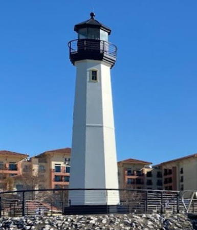
2007. Active, charted by Navionics; focal plane about 39 ft (12 m); continuous white light. 35 ft (11 m) octagonal steel tower with lantern and gallery. Tower painted white, lantern black. Juan Mauricio's 2022 photo is at right, a 2017 photo is available, Michael Zheng has a sunset photo of the lighthouse in action, and Google has a street view and a satellite view. The lighthouse is in the city of Rockwall, on the east side of Lake Ray Hubbard, a reservoir in the eastern suburbs of Dallas. The lighthouse guides visitors arriving by boat at a downtown development that includes restaurants, shopping, and a hotel. In July 2021 the lighthouse was dedicated to the memory of former mayor and county commissioner Scott Self. Located on the harbor breakwater; accessible by walking the pier. Site open, tower closed. Owner/operator: The Harbor Rockwall. .

Information available on lost lighthouses:

  • Brazos Santiago (1854-1974), southern tip of South Padre Island. The first lighthouse was destroyed by Confederate troops during the Civil War; it was replaced by a temporary structure in 1864. Huelse has a historic postcard view of the third (1878) lighthouse; it was destroyed by fire in 1940. The light was re-established in 1943 atop the South Padre Island Coast Guard Station. It was probably deactivated when the station building was replaced in 1974. ARLHS USA-081.
  • Corpus Christi (1859-1878), downtown Corpus Christi near the modern intersection of North Upper Broadway and Buffalo Street. Nothing remains of the lighthouse but a historical marker has been placed at the site. Google has a street view of the marker. ARLHS USA-1137.
  • East Shoal (1872-1875), Saluria Bayou near Port O'Connor. The lighthouse was destroyed by a storm in 1875. ARLHS USA-1138.
  • Saluria (1858-1861), near Port O'Connor. The lighthouse was destroyed by Confederate troops early in the Civil War. ARLHS USA-1139.
  • Swash (1858-1861), Matagorda Bay. The lighthouse was burned by Confederate troops early in the Civil War. There was a project to rebuild it in 1871 but there's no record it was ever reactivated. ARLHS USA-1182.
  • West Shoal (1872-1875), Saluria Bayou near Port O'Connor. The lighthouse was destroyed by a hurricane in 1875. ARLHS USA-1140.
 

Scott Self Light, Rockwall, January 2022
Google Maps photo by Juan Mauricio
 

Notable faux lighthouses:

Adjoining pages: North: Southeast Texas | South: Mexico Northern Gulf Coast

Return to the Lighthouse Directory index

Checked and revised November 24, 2024. Lighthouses: 40. Site copyright 2024 Russ Rowlett and the University of North Carolina at Chapel Hill.