Lighthouses of Norway: Northern Sunnmøre

The Kingdom of Norway (Norge in Norwegian) is one of the world's most maritime nations. The country is long and narrow, with drowned valleys called fjords that bring the sea far inland in most regions. The mainland coast is estimated to be 2650 km (1650 mi) long and when all the islands and minor indentations are counted the total coastline approaches an astonishing 60,000 km (37,500 mi), long enough the go around the world one and a half times. With such a lengthy and rocky shore it's not surprising that Norway has a large number of lighthouses.

Norway is divided into counties (fylker) and the counties are divided into municipalities (kommuner). This page includes lighthouses in the southern part of Møre og Romsdal County in the central part of the west coast. Southern Møre og Romsdal is the traditional district called Sunnmøre. However, Sunnmøre has so many lighthouses it needs two pages. The Southern Sunnmøre page includes the lighthouses south of Alesund, and this page includes lighthouses in the Alesund area and northward.

In Norwegian a lighthouse is a fyrtårn (fire tower) or simply a fyr; a fyrlykt is a beacon and a lyktehus is a lantern. Øy is an island, holmen is an islet, skjær is a skerry (a tiny island or rocky reef), sund is a strait (often between an island and the mainland), bukt is a bay, nes is a headland, and havn is a harbor.

Aids to navigation are maintained by the Kystverket (Coast Directorate), an agency of the Ministry of Transport and Communications.

ARLHS numbers are from the ARLHS World List of Lights. NF numbers are from the Norsk Fyrliste. Admiralty numbers are from volume L of the Admiralty List of Lights & Fog Signals. U.S. NGA List numbers are from Publication 115, but in 2018 NGA dropped many of its listings for the Norwegian fjords.

General Sources
Norsk Fyrhistorisk Forening
News and photos from the Norwegian Lighthouse Association.
Online List of Lights - Norway - Northwest Coast
Photos by various photographers posted by Alexander Trabas. Many of the photos for this area are by Michael Boucher, Erich Hartmann, or Arno Siering.
Lighthouse Pages from Anke and Jens - Norway
Excellent photos of more than 60 Norwegian lighthouses.
Norway's Fjorden and Lighthouses
Photos taken by Charles W. Bash on a 2010 cruise from Bergen to North Cape.
Leuchttürme an der norwegischen Küste
Photos posted by Bernd Claußen.
Leuchttürme in Norwegen
Photos posted by Andreas Köhler.
Lighthouses in Ålesund Area
Photos by various photographers available from Wikimedia.
Norwegische Leuchttürme auf historischen Postkarten
Historic postcard images posted by Klaus Huelse.
Norske Fyr
From Wikipedia, a handy list of Norwegian light stations with their dates of establishment.
Norsk Fyrliste
The official Norwegian light list can be downloaded in six .pdf volumes.
Google Maps
Satellite view of the Sunnmøre area.


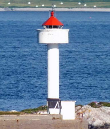
Alnes Light, Giske, August 2023
Instagram photo by Maryam Alzood

Sula Lighthouses
Kveitskjer (2)
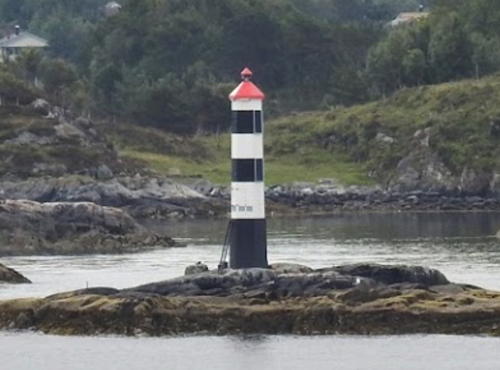
2015. Active; focal plane 11.5 m (38 ft); flash every 5 s, white, red or green depending on direction. 9.5 m (31 ft) octagonal fiberglass tower colored with black and white horizontal bands and a red roof. A 2019 view from the sea is at right, Trabas has Rainer Arndt's 2017 photo, Luciano Robles has a 2024 view, and Google has a satellite view that appears to show the former lighthouse. This light replaced an 8 m (26 ft) lantern mounted on a platform supported by four straight piles. Located on a skerry in the Hessefjord off the north coast of Sula, about 2.5 km (1.5 mi) south of Ålesund. Accessible only by boat. Site open, tower closed. NF-331000; Admiralty L0768; ex-NGA 6088.
Svinholmen
Date unknown. Active; focal plane 4 m (13 ft); white, red or green light, depending on direction, 2 s on, 2 s off. 5 m (17 ft) lantern mounted on a concrete pier. Lantern painted white with a red roof. Trabas has Boucher's 2011 photo and Google has a satellite view. Located on the western end of Svinholmen, an island off the north coast of Sula. Accessible only by boat. Site open, tower closed. NF-331200; Admiralty L0770; ex-NGA 6092.

Ålesund Lighthouses
The principal town of Sunnmøre, Ålesund has a population of nearly 70,000.

Flisneset
Date unknown. Active; focal plane 7 m (23 ft); white, red or green light, depending on direction, occulting twice every 8 s. 6 m (20 ft) square skeletal tower with lantern and gallery. Lighthouse painted white; lantern roof painted red. Trabas has Siering's 2012 photo, Kenneth Enstad has a photo, and Google has a satellite view. Located on a point of land projecting into the Storfjord, about 3 km (2 mi) southeast of Vegsundet. Accessible only by boat. Site open, tower closed. NF-305700; Admiralty L0576; ex-NGA 5696.

Kveitskjer Light, Sula, July 2019
Google Maps photo by ubeetrip
* Steinvåg
Date unknown. Inactive since 2024. 9 m (30 ft) lantern and gallery mounted on tripod piles. Trabas has Boucher's photo and Google has a satellite view. This light guided vessels entering the harbor on the south side of Ålesund. Located on a promontory at the west end of the harbor. Site open, tower closed. ex-NF-330000; ex-Admiralty L0765; ex-NGA 6084.
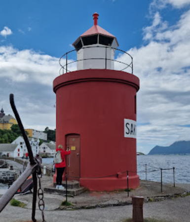
** Ålesund Molja
1858. Active; focal plane 8 m (26 ft); white, red or green light, depending on direction, occulting once every 6 s. 8 m (26 ft) round cylindrical stone tower with lantern and gallery. Tower painted red; the lantern is white with a red roof. A 2024 photo is at right, Trabas has Siering's 2012 photo, Bash has a photo, Köhler has a closeup, Wikipedia has a photo by Joachim Müllerchen, another photo is available, Anke and Jens have a page for the lighthouse, Huelse has a historic postcard view, and Google has a street view and a satellite view. In 1886 the tower was extended 3 m (10 ft) by adding a second floor. The lighthouse is leased to a hotel and is renovated as a "perfect location for special occasions," popular with newlyweds. Located on the waterfront of Ålesund; accessible by walking the short pier. Site open, tower open to hotel guests. Owner: Kystverket. Site manager: Hotel Brosundet (Molja Lighthouse).. ARLHS NOR-289; NF-329500; Admiralty L0761; ex-NGA 6080.
Kalvøyskjæret
Date unknown. Active; focal plane 7.5 m (25 ft); white, red or green light, depending on direction, 3 s on, 3 s off. 6 m (20 ft) concrete post with lantern and gallery. Lighthouse painted white, lantern roof red. No photo available but Google has a satellite view. Located on a skerry off the northeastern tip of Kalvøy, about 10 km (6 mi) east of Ålesund. Accessible only by boat. Site open, tower closed. NF-334900; Admiralty L0799; ex-NGA 6068.

Skodje Lighthouses
Dyrøy
Date unknown. Active; focal plane 4.5 m (15 ft); white, red or green light, depending on direction, occulting twice every 8 s. 5 m (17 ft) lantern mounted on a stone base. No photo available but Google has a satellite view and a very distant street view across the fjord from Leirvika. Located at the northwestern corner of Dyrøy, an island about 16 km (10 mi) east of Ålesund. Site status unknown. NF-335200; Admiralty L0799.6; ex-NGA 6076.
Valleskjær
Date unknown. Active; focal plane 7 m (23 ft); white, red or green light, depending on direction, 3 s on, 3 s off. 6 m (20 ft) square tower with lantern and gallery. Lighthouse painted white, lantern roof red. Trabas has Rainer Arndt's 2018 photo and Google has a satellite view. Located on a skerry on the north side of the Storfjord near Valle. Site open, tower closed. NF-306300; Admiralty L0588; ex-NGA 5712.

Ålesund Mole Light, Ålesund, July 2024
Google Maps photo by R.T.

Giske Lighthouses
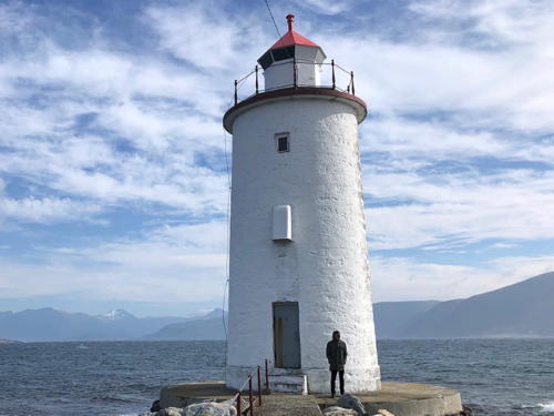
* Hogsteinen
1857. Active; focal plane 12 m (39 ft); white, red or green light, depending on direction, occulting once every 6 s. 13 m (43 ft) round brick tower with lantern and gallery. Lighthouse painted white; lantern roof is red. A 2021 photo is at right, Trabas has Ronald Wöhrn's 2007 photo, Martin Sercombe also has a photo, Kjell Jøran Hansen has a 2011 photo, a sunset view is available, Anke and Jens have a good photo, Ingo Maack has a closeup street view, and Google has a satellite view and a distant street view. The original lantern was replaced in 1905. This is one of the few brick lighthouses ever built in Norway, and it is protected under the Cultural Heritage Act. Built at the end of a stone mole, the light marks the southeastern point of the island of Godøya. The island is connected to Ålesund by a series of bridges and tunnels. Accessible by walking the mole. Site open, tower closed. . ARLHS NOR-121; NF-328500; Admiralty L0756; NGA 6044.
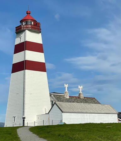
**** Alnes (2)
1876 (station established 1853). Active; focal plane 36 m (118 ft); white, red or green light, depending on direction, occulting twice every 8 s. 26 m (75 ft) square shingle-covered wood tower with lantern and gallery, attached to a 1-1/2 story wood keeper's house. Lighthouse painted white with two red horizontal bands, gallery white with red trim, lantern red. Maryam Alzood's 2023 photo is at the top of this page, Wikipedia's article on the lighthouse has a photo, Kjell Jøran Hansen also has a closeup photo, Trabas has Ronald Wöhrn's 2009 photo, Anke and Jens have a page with good photos, the Lighthouse Association has a page for the lighthouse, Jonson Li has a street view, and Google has a satellite view. Readily accessible from Ålesund, this unusual and historic tower is one of Norway's most visited lighthouses. Automated in 1982, it is now managed by Giske Kommune. The station is operated as a cultural center and historic museum, with an exhibition hall and a café. Huelse has a historic postcard view of the original lighthouse as well as a postcard view of the present lighthouse. Located in the village of Alnes at the northwestern point of Godøya. Site open; cultural center and tower open daily June through August and on Sundays otherwise March through October. Owner: Giske Kommune. Site manager: Stiftelsen Alnes Fyr . ARLHS NOR-299; NF-338700; Admiralty L0832; NGA 6192.

Hogsteinen Light, Giske, June 2021
Instagram photo by lafeedunord
* Valderhaug Molo
Date unknown. Active; focal plane 7 m (23 ft); red light, 1 s on, 1 s off. 8 m (26 ft) lantern and gallery on four straight piles, mounted on a concrete pier. Lantern painted white with a red roof, piles painted black. Morten Husum has a 2020 photo, Köhler has a closeup 2009 photo, another photo is available, and Google has a satellite view and a distant 2022 street view. Located just offshore at Valderhaug, on the island of Valderøy about 2.5 km (1.5 mi) northwest of Ålesund. Site open, tower closed. NF-336002; Admiralty L0759.5; ex-NGA 6058.
* Synes (Syneset) (4)
1959 (station established 1870). Active; focal plane 19 m (62 ft); white, red or green light, depending on direction, 2 s on, 2 s off. 8.5 m (28 ft) concrete post with lantern and gallery. Lighthouse painted white, lantern roof red. Anke and Jens have a page with photos, Köhler has a closeup photo, and Haavard Kristiansen has a distant 2023 view. Foundations of the second (1913) lighthouse are beside the tower and are visible in Google's satellite view. Located at the tip of a promontory at Synes, in the southwestern corner of the island of Vigra. Site open, tower closed. ARLHS NOR-239; NF-340000; Admiralty L0842; NGA 6208.
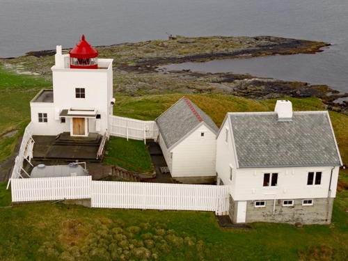
Erkna (2)
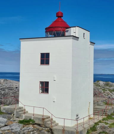
1950 (station established 1869). Active; focal plane 49 m (161 ft) and, for a second light, 44 m (144 ft); both lights show white, red or green light, depending on direction, occulting three times every 10 s. This light displays no less than 18 sectors. 10 m (33 ft) square cylindrical concrete tower, attached to a 1-1/2 story keeper's house. Lighthouse painted white, lantern red. A 2019 Kystverket photo is at right, Kenneth Enstad has a closeup, Trabas has Rainer Arndt's distant 2017 view, Anke and Jens have a view from the sea, and Google has a satellite view. The original lighthouse was destroyed in 1945. Erkna is an island about 5 km (3 mi) northwest of Alnes Fyr and 3 km (2 mi) west northwest of Synes Fyr. The island is a nature reserve protecting a flock of wild sheep, and the lighthouse is leased to a caretaker. Located atop a bluff on the northwestern coast of the island. Accessible only by boat in heavy seas; there are distant views from Alnes Fyr and Synes Fyr. Site status unknown. . ARLHS NOR-011; NF-340500; Admiralty L0852; NGA 6212.

Erkna Light, Giske, May 2019
Facebook photo posted by Kystverkmusea (Kystverket Museum)
* Blindheim
Date unknown (station established 1893). Inactive since 2024. 8 m (26 ft) square skeletal tower, covered with white siding, with lantern and gallery. Lighthouse painted white; lantern roof painted red. Andreas Köhler has a 2009 photo, Branislav Beliancin has a 2011 closeup, and Google has a satellite view. Located on the northwestern coast of the island of Vigra, about 3 km (2 mi) west of Roald. Accessible by road. ex-NF-341000; ex-Admiralty L0848; NGA 6216.
* Molnes
Date unknown. Apparently inactive. Approx. 6 m (20 ft) square pyramidal metal tower with lantern and gallery. Lighthouse painted white; lantern roof is red. Köhler has a photo, Branislav Beliancin has a closeup, and Google has a satellite view. Located at the northwestern tip of Vigra island about 2.5 km (1.5 mi) northwest of Roald. The island is accessible by ferry. Site open, tower closed. ARLHS NOR-409; ex-NF-341100; ex-Admiralty L0850; NGA 6220.
Rosholmen
1908 (station established 1881). Active; focal plane 14 m (46 ft); flash every 5 s, white, red or green depending on direction. 8 m (26 ft) conical iron tower with lantern. Tower painted red, lantern white. No photo available but Bing has an indistinct satellite view. Located on a skerry about 2 km (1.2 mi) northwest of Vigra. Accessible only by boat in heavy seas; there is a distant view from Vigra. Site and tower closed. NF-342500; Admiralty L0856; NGA 6228.
Storholmen
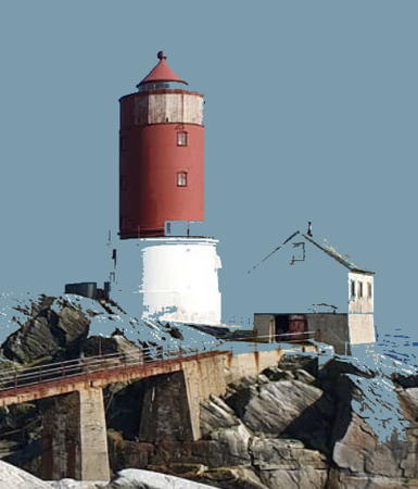
1920. Active; focal plane 36 m (118 ft); white, red or green light, depending on direction, occulting once every 6 s. 22 m (72 ft) round cylindrical cast iron tower with lantern and gallery, mounted on a round cylindrical 2-story stone base. Lighthouse painted red, except the stone base is painted white. A 2019 photo is at right, a page for the lighthouse has a closeup photo, a kayaker reports on a visit with several photos, Wikipedia has a page with a photo, Trabas has a distant 2016 view by Klaus Wolfgang, and Google has a satellite view. Keepers were often stranded for long periods at this lighthouse; it was difficult to supply them even during the summer. Located on a tiny skerry in the Norwegian Sea about 6 km (3.5 mi) due north of Erkna and 8 km (5 mi) northwest of the populated island of Vigra. This remote lighthouse is only accessible safely by helicopter; there may be a distant view from Vigra. Site and tower closed. . ARLHS NOR-231; NF-342000; Admiralty L0854; NGA 6224.

Storholmen Light, Norwegian Sea, JApril 2019
Instagram photo by royjossund

Haram Lighthouses
The Nordøyvegen (North Islands Way) Project, completed in 2022, connects the main islands of Haram to the mainland by a tunnel and a series of bridges between the islands. Perhaps because of this new connection at the start of 2020 the Sandøy municipality and the islands of the Haram municipality were merged into the Ålesund municipality. Lighthouses of Sandøy are described on the Romsdal page.

Håstein
Date unknown. Active; focal plane 4.5 m (15 ft); white, red or green light, depending on direction, 3 s on, 3 s off. 6 m (20 ft) concrete post with lantern and gallery. Lighthouse painted white, lantern roof red. No closeup photo available but Google has a satellite view. At maximum zoom the light is visible in Ciprian Bogdan Ghioc's sea view. Located on a reef off the southern end of Terøy. Accessible only by boat. Site open, tower closed. NF-337000; Admiralty L0814; ex-NGA 6156.
#Søre Kverna
Date unknown. Light inactive since 2014 and more recently removed. 8.5 m (28 ft) concrete post with lantern and gallery. Lighthouse painted white; lantern roof is red. The active light had been moved to the top of the lantern. Bash has a 2010 photo but the lighthouse is no longer seen in Bing's satellite view. The light marked a dangerous reef in the inland passage between Lepsøya and the mainland. Located about 800 m (1/2 mi) northwest of Åsegarden. Accessible only by boat. Site open, tower closed. ex-NF-337400; ex-Admiralty L0818; NGA 6168.
* Lepsøyrev
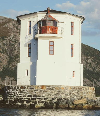
1879; lightship station established 1856. Inactive since 2014. 12 m (39 ft) octagonal cylindrical stone tower, painted white. There's a lantern on a "shelf" on the seaward side, as seen in the 2023 photo at right. The lantern roof is red. Bash has a photo, Wikipedia has a Norwegian page with a photo, Joar Karsten Øygard has a 2022 closeup, Anke and Jens have a page for the lighthouse, and Google has a satellite view and a distant street view. The lighthouse marks a dangerous reef. It was repaired after being damaged by Allied bombing in 1944. A preservation group, the Lepsøyrevets Fyrvenner, was formed in 2009 to work for restoration of the lighthouse. When Michael Boucher passed the lighthouse in September 2011 it was under restoration and covered by scaffolding.The restored lighthouse is available for rental. Located at the end of a mole on a small island off the southeastern tip of Lepsøya and a short distance west of Skjelten on the Haram peninsula. Site open, tower closed. Owner: Kystverket. Site manager: Lepsøyrevets Fyrvenner . ARLHS NOR-154; ex-NF-337600; ex-Admiralty L0820; ex-NGA 6176.
 

Lepsøyrevet Light, Haram, January 2023
Facebook photo by Lepsøyrevets Fyrvenner
Innholmen (2)
Date unknown. Active; focal plane 18 m (59 ft); white, red or green light, depending on direction, occulting twice every 8 s. 6 m (20 ft) octagonal fiberglass tower colored with black and white horizontal bands and a red roof. Trabas has a 2024 photo by Conelia Grosch and Bing has a fuzzy satellite view. The original lighthouse was a square skeletal tower, covered with siding, with lantern and gallery. Trabas has Boucher's distant view. Located on a small island off the northwestern tip of Lepsøya. Accessible only by boat. Site open, tower closed. NF-343500; Admiralty L0860; NGA 6236.
Hellevik Range Rear (2)
1918 (station established 1881). Inactive since 1988. Approx. 7 m (23 ft) square cylindrical wood tower with lantern and gallery, attached to the seaward end of a 1-1/2 story keeper's house. Lighthouse painted white, lantern red. Adnan Maksumic's 2022 photo is at right, a blogger has a closeup photo (2/3 the way down the page), Iwan Groot has a photo, Anke and Jens has a page for the station, and Google has a satellite view. The lighthouse was the rear light of a range from sometime in the early 1900s until 1988, when the front light (next entry) was converted to a leading light. Norwegian Wikipedia also has a page with a historic photo. The lighthouse was sold as a private residence. Located at Hellevik on the north side of the island of Lepsøya. Site and tower closed (private property). ARLHS NOR-114; ex-Admiralty L0864.1.
Hellevik (2) (former Range Front)
1988 (station establishment date unknown). Active; focal plane 13 m (43 ft); white, red or green light, depending on direction, occulting once every 6 s. 6 m (20 ft) square skeletal tower, covered with siding, with lantern and gallery. Lighthouse painted white, lantern red. Trabas has a 2024 closeup by Cornelia Grosch, Arneka Tuki has a 2022 photo, and Google has a satellite view. Located about 400 m (1/4 mi) west of the historic lighthouse. Site and tower closed (private residence). NF-344100; Admiralty L0864; NGA 6240.

Hellevik Light, Haram, April 2022
Google Maps photo by Adnan Maksumic
Ulla (2)
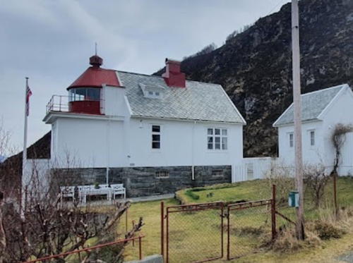
1950 (station established 1874). Active; focal plane 22 m (72 ft); white, red or green light, depending on direction, occulting twice every 8 s. 10 m (34 ft) square cylindrical concrete tower with lantern and gallery, painted white; lantern roof painted red. Two 1-1/2 story keeper's houses, boathouses, and other station buildings preserved. Kristin Sollied's 2022 photo is at right, Trabas has a 2024 photo by Cornelia Grosch, Agnete Syrtveit has a 2009 photo, Anke and Jens have a page with an excellent photo, Svein Petter Måseidvåg has a closeup photo, Kenneth Enstad has a good 2011 photo, and Google has a satellite view of the station. The lighthouse was severely damaged by an Allied bombing raid in 1944 and was rebuilt after the war. The new version of the lighthouse stands on the site of the former keeper's house. Automated since 1975, the station is now maintained by the Ullafyrets Venner (Friends of Ulla Lighthouse). Overnight accommodations for groups up to 22 are available, and a café serves waffles and coffee. Located on Kværnholmen, a small island just off the northwest end of the larger island of Haramsøya. The light station is accessible by road from Austnes on Haramsøya, which is accessible by ferry; a footbridge leads to the station. Site open, café open mid May through mid September, tower status unknown. Owner: Kystverket. Site manager: Ullafyrets Venner . ARLHS NOR-259; NF-345000; Admiralty L0872; NGA 6260.
Naustskjæret
Date unknown. Active; focal plane 5 m (17 ft); white, red or green light, depending on direction, occulting three times every 10 s. 9.5 m (31 ft) concrete post with lantern and gallery. Lighthouse painted white, lantern roof red. Google has a street view and a satellite view. Located on a shoal under the bridge connecting Haramsøya and Flemsøya. Accessible only by boat. Site open, tower closed. NF-344900; Admiralty L0870; NGA 6256.
Kjeholmen (2)
1916. Active; focal plane 12 m (39 ft); flash every 5 s, white, red or green depending on direction. 8 m (26 ft) fiberglass tower, colored white with a black horizontal band; lantern roof is red. No photo available but Google has a satellite view, This light replaced a 6 m (20 ft) square skeletal tower. Anke and Jens have a page for the earlier light. Located on an islet off the north side of Flemsøya. Accessible only by boat. Site open, tower closed. NF-345500; Admiralty L0876; NGA 6264.
Fjørtoftneset (2)
2017 (station established 1916). Active; focal plane 17 m (56 ft); white, red or green light, depending on direction, 2 s on, 8 s off. 9 m (30 ft) octagonal fiberglass tower colored with black and white horizontal bands and a red roof. Ole W. Moe Lund has a street view, a closeup is available, and Google has a satellite view. This light replaced a square skeletal tower, upper portion covered with white siding, with lantern and gallery. Located on the western tip of Fjørtofta. Site open, tower closed. NF-345600; Admiralty L0880; NGA 6268.

Ulla Light, Haram, August 2022
Instagram photo by Kristin Sollied
Haugnes (2)
Date unknown. Active; focal plane 5.5 m (18 ft); white, red or green light, depending on direction, occulting once every 6 s. 6 m (20 ft) square skeletal tower, covered by white siding, with lantern and gallery. Lighthouse painted white, lantern roof red. Trabas has Boucher's 2011 photo and Google has a satellite view and a distant street view. Located on a promontory of the mainland opposite Haramsøya. Site status unknown (the light appears to be on a farm). NF-338000; Admiralty L0824; NGA 6180.
Raudholmane (Rødholmen) (2)
1954 (station established 1893). Active; focal plane 14.5 m (48 ft); flash every 5 s, white, red or green, depending on direction. 11.5 m (38 ft) concrete post with lantern and gallery. Lighthouse painted white, lantern red. Trabas has Arno Siering's 2012 photo (also seen at right) and Google has a satellite view. The original lighthouse was a keeper's house with lantern. These buildings were demolished when the light was automated in 1954 but foundation ruins can be seen next to the modern light. Located on a skerry southeast of Skuløya and about 5 km (3 mi) north of Brattvåg. Accessible only by boat. Site open, tower closed. NF-338200; Admiralty L0826; NGA 6184.
Boltholmen
Date unknown. Active; focal plane 7 m (23 ft); white, red or green light, depending on direction, occulting twice every 8 s. 5.5 m (18 ft) square skeletal tower, covered with white siding, with lantern and gallery. Lighthouse painted white, lantern red. Trabas has Boucher's 2011 photo and Google has a satellite view and a distant 2019 street view. Located on an island in the Samsfjord at the entrance to Brattvåg. Accessible only by boat. Site open, tower closed. NF-358500; Admiralty L0940; NGA 6428.
Bårsnes
Date unknown. Active; focal plane 6 m (20 ft); white, red or green light, depending on direction, occulting twice every 8 s. 6 m (20 ft) square skeletal tower, covered with white siding, with lantern and gallery. Lighthouse painted white, lantern red. No photo available but Google has a satellite view. Located on a promontory on the east side of the Tomrefjord. Site status unknown. NF-363000; Admiralty L0962; NGA 6484.

Information available on lost lighthouses:


Raudholmane Light, Haram, June 2012
photo copyright Arno Siering; used by permission

Notable faux lighthouses:

Adjoining pages: North: Romsdal (Molde Area) | South: Southern Sunnmøre

Return to the Lighthouse Directory index | Ratings key

Posted June 19, 2006. Checked and revised August 19, 2025. Lighthouses: 31. Site copyright 2025 Russ Rowlett and the University of North Carolina at Chapel Hill.