Lighthouses of Norway: Southern Sunnmøre

The Kingdom of Norway (Norge in Norwegian) is one of the world's most maritime nations. The country is long and narrow, with drowned valleys called fjords that bring the sea far inland in most regions. The mainland coast is estimated to be 2650 km (1650 mi) long and when all the islands and minor indentations are counted the total coastline approaches an astonishing 60,000 km (37,500 mi), long enough the go around the world one and a half times. With such a lengthy and rocky shore it's not surprising that Norway has a large number of lighthouses.

Norway is divided into counties (fylker) and the counties are divided into municipalities (kommuner). This page includes lighthouses of the southern part of Møre og Romsdal County in the central part of the west coast. Southern Møre og Romsdal is the traditional district called Sunnmøre. However, Sunnmøre has so many lighthouses it needs two pages. This page includes the lighthouses south of Alesund, and the Northern Sunnmøre page includes lighthouses in the Alesund area and northward.

In Norwegian a lighthouse is a fyrtårn (fire tower) or simply a fyr; a fyrlykt is a beacon and a lyktehus is a lantern. Øy is an island, holmen is an islet, skjær is a skerry (a tiny island or rocky reef), sund is a strait (often between an island and the mainland), bukt is a bay, nes is a headland, and havn is a harbor.

Aids to navigation are maintained by the Kystverket (Coast Directorate), an agency of the Ministry of Transport and Communications.

ARLHS numbers are from the ARLHS World List of Lights. NF numbers are from the Norsk Fyrliste. Admiralty numbers are from volume L of the Admiralty List of Lights & Fog Signals. U.S. NGA List numbers are from Publication 115, but in 2018 NGA dropped many of its listings for the Norwegian fjords.

General Sources
Norsk Fyrhistorisk Forening
News and photos from the Norwegian Lighthouse Association.
Online List of Lights - Norway - Northwest Coast
Photos by various photographers posted by Alexander Trabas. Many of the photos for this area are by Michael Boucher, Erich Hartmann, Arno Siering, or Ronald Wöhrn.
Lighthouse Pages from Anke and Jens - Norway
Excellent photos of more than 60 Norwegian lighthouses.
Norway's Fjorden and Lighthouses
Photos taken by Charles W. Bash on a 2010 cruise from Bergen to North Cape.
Leuchttürme an der norwegischen Küste
Photos posted by Bernd Claußen.
Leuchttürme in Norwegen
Photos posted by Andreas Köhler.
Lighthouses in Ålesund Area
Photos by various photographers available from Wikimedia.
Norwegische Leuchttürme auf historischen Postkarten
Historic postcard images posted by Klaus Huelse.
Norske Fyr
From Wikipedia, a handy list of Norwegian light stations with their dates of establishment.
Norsk Fyrliste
The official Norwegian light list can be downloaded in six .pdf volumes.
Google Maps
Satellite view of the Sunnmøre area.


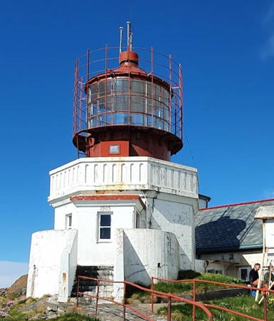
Svinøy Light, Sande, June 2020
Instagram photo by Roy Jøssund
Vanylven Lighthouses
* Sylte (Strand)
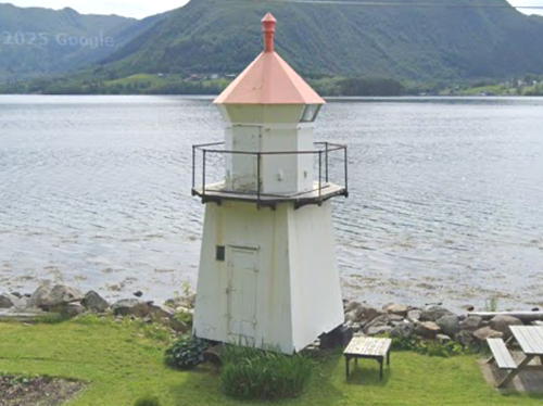
Date unknown. Active; focal plane 5 m (17 ft); white, red or green light, depending on direction, occulting three times every 10 s. 6 m (20 ft) octagonal lantern mounted on a square skeletal tower covered by wood siding. Lighthouse painted white, lantern roof red. Googles' 2025 street view is at right, Trabas has Siering's 2015 photo, a 2008 photo is available, and Google has a satellite view. Located on the north side of the Syltefjord about 4 km (2.5 mi) east of Vanylven on highway 61. Readily accessible from the highway, which follows the fjord. Site open, tower closed. NF-301800; Admiralty L0540; NGA 5628.
#Åramsund (Bleka) (2)
1897. Inactive since 2023 and since removed. This as a 6 m (20 ft) round fiberglass lantern and gallery mounted on a cylindrical stone beacon. Lantern painted white with a red roof; stone column painted black. Trabas has Siering's photo, a distant view is available (third row from the bottom), and Google has a satellite view. Google's 2025 street view confirms the removal. A nearby active light on a post (seen in the street view) has focal plane 6 m (20 ft); green flash every 3 s. Located on a skerry off the ferry terminal at Åram; ferries link this point to Larnes, on the other side of the Åramsund, and to the island of Voksa. Accessible only by boat. Site and tower closed. ex-NF-302200; ex-Admiralty L0542; ex-NGA 5632. Active light: NF-301007; Admiralty L0542.5.
* Syvdsfjorden
Date unknown. Inactive since 2023 and since removed. This was a 6 m (20 ft) square tower with lantern and gallery. Lighthouse painted white, lantern roof red. Google has a 2022 street view, but Google's 2025 street view and satellite view confirm the removal. A nearby active light on a post has focal plane 7 m (23 ft); red light, 1 s on, 1 s off. NGA misspells the name as Sovdefjorden. Located beside highway 652 on the east side of the Syvdsfjord, opposite Eidsa. Site open, tower closed. ex-NF-303200; ex-Admiralty L0552; ex-NGA 5652. Active light: NF-303202; Admiralty L0550.

Sylte Light, Vanylvan, June 2025
Google street view

Sande Lighthouses
Haugsholmen (Frekøy) (1)
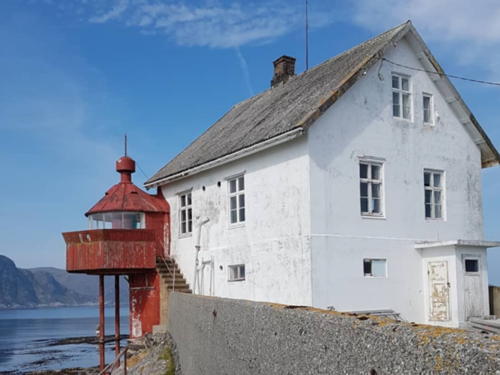
1876. Inactive. 10 m (33 ft) cylindrical tower with lantern and gallery, attached to one corner of a 2-1/2 story keeper's house. Lighthouse painted red, house white. A photo is at right, the Stiftinga Sunnmøre Museum has a photo, Anke and Jens have a page for the lighthouse, Jens Inge Ringstad has a closeup photo, Ole Amundsen has a view from the sea, Wikimedia has a historic photo, and Google has a satellite view. Automated in 1979, the house was reported to be abandoned and deteriorating. In 2007 it was purchased by Sande Kommune. A preservation society, Forening for Frekøy Fyrstasjon , has been formed to work for the restoration of the station; work was beginning in 2010. In 2018 interior retoration was in progress with the goal of making the house available for overnight stays. Located at the western tip of Frekøy, an island in the Vanylvsfjord about 10 km (6 mi) west of Larsnes. Accessible only by boat. Owner: Sande Kommune. Site status unknown. ARLHS NOR-111.
Haugsholmen (2)
Date unknown. Active; focal plane 20 m (66 ft); white, red or green light, depending on direction, occulting three times every 12 s. 6 m (20 ft) octagonal fiberglass tower colored white with two narrow black horizontal bands. No photo available but Google has a satellite view. Located about 30 m (100 ft) south of the historic lighthouse. Site status unknown. NF-301000; Admiralty L0530; NGA 5608.
Agnskjæret (2)
Date unknown. Active; focal plane 10.5 m (34 ft); white, red or green light, depending on direction, 3 s on 3 s off. 13 m (43 ft) octagonal fiberglass tower colored white with two narrow black horizontal bands.No photo available but Google has an satellite view. The previous light was a lantern and gallery mounted on a tall tripod. Google has a very distant 2010 street view of the original lighthouse. Located on a shoal off the south side of Kvamsøya. Accessible only by boat. Site open, tower closed. NF-300900; Admiralty L0531; NGA 5604.
* Sandshamn
1915. Active; focal plane 5 m (17 ft); white, red or green light, depending on direction, 3 s on, 3 s off. 7 m (23 ft) concrete post with lantern and gallery. Lighthouse painted white; lantern roof is red. Geir Myrind has a distant view and Google has a closeup street view and a distant satellite view. Located at the end of the north breakwater protecting the harbor of Sandshamn, on the east end of the island of Sandsøy, about 7 km (4.5 mi) northwest of Larsnes. Accessible by walking the pier. Site open, tower closed. NF-309000; Admiralty L0656; NGA 5756.

Haugsholmen Light, Sande
Google Maps photo posted by Jo Lee
Svinøy
1905. Active; focal plane 46 m (151 ft); two white flashes every 30 s. 11 m (36 ft) octagonal stone tower with lantern and gallery, attached to the seaward end of a keeper's house. Lighthouse painted white with red trim, lantern red. Roy Jøssund's 2020 photo is at the top of this page, a view from the sea is available, Trabas has Boucher's 2011 photo, the Lighthouse Association has a page for the lighthouse, Frode Pilskog posted a 2009 photo, Wikimedia has a collection of historic photos, and Google has a satellite view of the station. The lighthouse was damaged by an Allied bombing raid in 1940 but was repaired after the war. The lighthouse, one of Norway's most difficult assignments for lightkeepers, was finally automated in 2005 on the 100th anniversary of its establishment. The keeper's quarters was formerly available for overnight stays by small groups, but in September 2012 the government restricted helicopter flights to the island to those required for lighthouse maintenance and repairs. Located on a small island in the Norwegian Sea about 20 km (13 mi) northwest of Larsnes. Accessible only by boat in heavy seas. Site and tower closed. . ARLHS NOR-042; NF-300000; Admiralty L0650; NGA 5600.
Saudeholmen (2)
Date unknown. Active; focal plane 9.5 m (31 ft); white, red or green light, depending on direction, 3 s on, 3 s off. 6 m (20 ft) round fiberglass tower with lantern and gallery. Lighthouse is white, lantern roof red. Alf Marius Grønnevik has a 2017 photo and Google has a satellite view. This lighthouse replaced the square wood tower with lantern and gallery seen in Petra Zachow's 2012 view from the sea. Located on a skerry in the Rovdefjord, off the south coast of Gurskøy about 3 km (2 mi) southeast of Larsnes. Accessible only by boat. Site open, tower closed. NF-303000; Admiralty L0548; NGA 5644.
Gjerdesvika Molo
Date unknown. Active; focal plane 10 m (33 ft); white, red or green light, depending on direction, occulting twice every 8 s. 8 m (26 ft) lantern on a platform supported by piles. Lantern painted white with a red roof. Trabas has Siering's 2015 photo and Google has a distant 2025 street view from shore and a distant satellite view. Located on the north mole at Gjerdesvika, a fishing port on the west coast of Gurskøy. May be accessible by walking the pier. Site status unknown. NF-311200; Admiralty L0668; NGA 5788.
Hidsneset
1902. Active; focal plane 16 m (52 ft); white, red or green light, depending on direction, 2 s on, 2 s off. 6 m (20 ft) square cylindrical concrete tower with lantern and gallery. Lantern painted white with a red roof, tower unpainted. A 2022 photo is at right, Trabas has Siering's 2015 photo, Jens Inge Ringstad has a photo, and Google has a distant 2025 street view and a satellite view. Located on a rocky point near the northwestern corner of Gurskøy, about 5 km (3 mi) southwest of Kvalsund. Site status unknown, but the light can be seen from the nearby coastal road. Site and tower closed. NF-312000; Admiralty L0670; NGA 5792.

Hidsneset Light, Sande, July 2022
Google Maps photo by Cam Camera

Herøy Lighthouses
Steinsholmskjeret
Date unknown. Active; focal plane about 7 m (23 ft); white, red or green light, depending on direction, occulting three times every 10 s. Approx. 6 m (20 ft) lantern on a square concrete base. Lantern painted white with a red roof; base painted black with a white horizontal band. Trabas has Boucher's 2011 photo, Bash has a distant view, and Google has a satellite view. NGA describes this light as a post and has a typo in its location (65° should be 62°). Located on a skerry off Steinholm on the north coast of Gurskøy. Accessible only by boat. Site open, tower closed. NF-313000; Admiralty L0684; NGA 5808.
Flåvær
1870. Active; focal plane 17 m (56 ft); white, red or green light, depending on direction, occulting three times every 10 s. 14 m (46 ft) square cylindrical wood tower with lantern and gallery, rising from the seaward gable of a 1-1/2 story wood keeper's house. Lighthouse painted white, lantern and gallery red. A 2025 photo by Alex Kurtz is seen at right, Allan Jones has a 2011 photo, Anke and Jens have a page for the lighthouse, Trabas has Wöhrn's 2007 photo, Bash has a 2010 photo, the Lighthouse Association has a page for the lighthouse, Wikimedia has a photo, and Google has a satellite view of the station. In 2010 Herøy Kommune and several area museums were considering managing the lighthouse, but it seems nothing came of this effort. Located on a small island about 2 km (1.2 mi) south of Kvalsund. Accessible only by boat. Site open, tower closed. . ARLHS NOR-085; NF-312500; Admiralty L0674; NGA 5800.
Kvaleklubben (Klubben)
Date unknown. Active; focal plane 6 m (20 ft); white, red or green light, depending on direction, occulting twice every 8 s. 6 m (20 ft) tower: octagonal lantern and gallery mounted on four staightpiles. Lantern painted white with a red roof; piles painted black. Trabas has Boucher's 2011 photo and Google has a satellite view. Located on a skerry in the Herøyfjord about 1200 m (3/4 mi) east of the Flåvær lighthouse. Accessible only by boat. Site open, tower closed. NF-312800; Admiralty L0676; ex-NGA 5804.
Lille Hestholmflu
Date unknown. Active; focal plane 6 m (20 ft); white, red or green light, depending on direction, occulting twice every 8 s. 9 m (30 ft) lantern and gallery mounted on tripod piles. Lantern painted white with a red roof. No photo available but Google has a distant satellite view. Located on a shoal in the Eiksundsleia sound, off the east coast of Gurskøy. Accessible only by boat. Site open, tower closed. NF-318200; Admiralty L0608; ex-NGA 5892.

Flåvær Light, Herøy, June 2025
Google Maps photo by Alex Kurtz
Kyrkjeholmen
Date unknown. Active; focal plane 9.5 m (31 ft); flash every 5 s, white, red or green depending on direction. 6 m (20 ft) concrete post with lantern and gallery. Lighthouse painted white; lantern roof painted red. Alex Kurtz has the 2025 photo at right, Bash has a 2010 photo, Trabas has Douglas Cameron's 2008 photo, and Google has a satellite view. Located on a skerry off the western tip of Bergsøy, about 1.6 km (1 mi) south of Kvalsund. Accessible only by boat. Site open, tower closed. NF-322000; Admiralty L0748; ex-NGA 5940.
* Gållanes (2)
Late 2022 or early 2023. Active; focal plane 10 m (33 ft); white, red or green light, depending on direction, occulting twice every 8 s. 8.5 m (28 ft) fibeerglass tower colored white with a black horizontal band; lantern roof is red. A distant 2023 photo is available and Google has a distant satellite view. This light replaced a 6 m (20 ft) square wood tower with lantern and gallery. Regina Traupyte has a May 2022 photo, Inge Kvalsvik has a closeup photo, and Andreas Köhler has a 2009 photo. Located at the northeastern corner of Nerlandsøy, about 800 m (1/2 mi) north of Kvalsvik. This location is accessible by a short walk. Site open, tower closed. ARLHS NOR-399; NF-326000; Admiralty L0730; NGA 6004.
* [Rundesund (Rundøysund, Sæviksten)] (2)
2025 (station established 1910). Active; focal plane 25 m (82 ft); white, red or green light, depending on direction, occulting three times every 10 s. 3 m (10 ft) round fiberglass lantern, colored white with a red roof. Alex Kurtz has a 2025 photo and Google has a 2025 street view and a satellite view. This light replaced an octagonal lantern; Trabas has Siering's 2015 photo and Köhler has a 2009 photo. Located at the northern tip of the island of Remøya, beside the south end of the Rundebrua, the bridge from Remøya to Runde. Site open, tower closed. ARLHS NOR-412; NF-326200; Admiralty L0726; NGA 6012.

Kyrkjeholmen Light, Herøy, Juky 2025
Google Maps photo by Alex Kurtz
** Runde (Rundøy) (4)
1935 (station established 1767). Active; focal plane 50 m (164 ft); white, red or green light, depending on direction, occulting once every 6 s. 14 m (46 ft) 2-story square masonry tower with lantern and gallery. Building painted white, lantern red. 1st order Fresnel lens is in use. Lisbeth Enger's 2023 photo is at right, Mark Koenig has a 2018 photo, Wikimedia has Chell Hill's 2012 photo, Unni-Lise Dahl has a photo of the lihthouse in action, Anka and Jens have a page for the lighthouse, Wikipedia has a view from the sea and an article in Norwegian, another view from the sea is available, Trabas has a 2024 photo by Cornelia Grosch, Daniel Knutsen has a street view, and Google has a satellite view of the station. This is one of the best preserved lighthouse stations in Norway, with practically all of its original buildings intact. The original lighthouse was replaced in 1826. A cast iron tower was installed in 1858; the base of that tower remains and the rest of it was relocated to the Sklinna lighthouse in Nord-Trondelag. Automated in 2002, the station now has overnight accommodations for groups of up to 20 hikers, in tours arranged by the Ålesund-Sunnmøre Tourist Association. The northernmost of the pictureseque islands in the Herøy municipality, Runde (Rundøy) is accessible from the mainland by a series of bridges. Located on the northwestern tip of the island, accessible by a hiking trail. Site open, tower open to guided tours. Site manager: DNT Sunnmøre. . ARLHS NOR-050; NF-327000; Admiralty L0722; NGA 6024.
Langenes
Date unknown. Active; focal plane 12 m (39 ft); two flashes every 5 s, white, red or green depending on direction. 4.5 m (15 ft) octagonal lantern on a square stone base. Lantern painted white with a red roof. Trabas has Siering's 2015 photo and Google has a satellite view. Located on a sharp promontory at the northeastern tip of Rundøy. Accessible only by boat. Site open, tower closed. NF-327400; Admiralty L0718; NGA 6032.
Torvikholmen
Date unknown. Active; focal plane 6.5 m (21 ft); white, red or green light, depending on direction, 1 s on, 1 s off. 6 m (20 ft) square pyramidal stone tower with lantern and gallery. Lighthouse painted white; lantern roof painted red. Trabas has Wöhrn's 2007 photo, Bash has a 2010 photo, and Google has a satellite view and a very distant street view. Located on a skerry marking a reef in the channel east of Leinøy. Accessible only by boat. Site open, tower closed. NF-315400; Admiralty L0692; ex-NGA 5848.

Runde Light, Herøy, May 2023
Google Maps photo by Lisbeth Enger

Ulstein Lighthouses
Teigesund
Date unknown. Active; focal plane 8 m (26 ft); white, red or green light, depending on direction, 3 s on, 3 s off. 4 m (13 ft) lantern on a stone base. Lantern painted white with a red roof. Trabas has Bash's distant 2010 photo and Google has a satellite view. Located on the Dimnanes promontory on the west side of Dimnøya. Accessible only by boat. Site open, tower closed. NF-315200; Admiralty L0688; ex-NGA 5840.
#Søre Lyngneskråka (1)
Date unknown. Replaced by 2010. This was a 6 m (20 ft) square skeletal tower, covered with siding, with lantern and gallery. Lighthouse painted white; lantern roof is red. Wikimedia has a 2006 photo. The active light (focal plane 5 m (17 ft); green flash every 3 s) is on a post; Google has an indistinct satellite view. Located on a skerry marking the east side of the entrance to the harbor of Ulsteinvik, a town on the west side of the island of Hareidlandet. Accessible only by boat. Site open, tower closed. Active light: NF-320201; Admiralty L0702.
[Grasøyane (Ulstein) (1)]
1886. Inactive since 1950. 1-1/2 story wood keeper's house; the lantern was mounted on or attached to the house. A 2024 photo of the station is available. The building was damaged during World War II, and after the war it was decided to move the light to a new cast iron tower.
Grasøyane (Ulstein) (2)
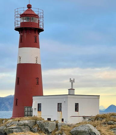
1950 (station established 1886). Active; focal plane 29 m (95 ft); white, red or green light, depending on direction, occulting twice every 8 s. 20 m (66 ft) round cast iron tower with lantern and gallery, painted red with one white horizontal band. Svein Sætre's 2021 photo is at right, a 2020 closeup and a 2025 view are available, Anke and Jens have a distant photo, Bash has a distant view, Trabas has Boucher's 2011 photo, the Lighthouse Association has a page for the lighthouse, and Google has a satellite view. This was the last cast iron lighthouse built in Norway. The light station was automated on its 100th anniversary in 1986. Standing off the Hareidlandet peninsula, the light marks the beginning of the approaches to Ulstein to the south and Ålesund to the west. In 2017 the Kystverket published a management study of the light station, but it's not clear if this has led to any action. Located on a small island about 15 km (9 mi) northwest of Ulstein and 5 km (3 mi) off the northwestern coast of the Hareidlandet. Accessible only by boat. Site open, tower closed. . ARLHS NOR-103; NF-327600; Admiralty L0712; NGA 6036.
Flørauden
Date unknown. Active; focal plane 12 m (39 ft); flash every 5 s, white, red or green depending on direction. 6 m (20 ft) tower: octagonal lantern and gallery mounted on four straightpiles. Lantern painted white with a red roof; piles painted black. Trabas has Boucher's 2011 photo, Bash has a distant view, and Google has a satellite view. Located on a small island on a reef about 4 km (2.5 mi) east of the Grasøyane lighthouse and 3 km (2 mi) northwest of Flø. NF-321500; Admiralty L0710; NGA 5936.

Grasøyane Light Station, Ulstein, January 2021
Instagram photo by Super Svein Sætre

Information available on lost lighthouses:

Notable faux lighthouses:

Adjoining pages: North: Northern Sunnmøre | South: Nordfjord

Return to the Lighthouse Directory index | Ratings key

Posted June 19, 2006. Checked and revised October 21, 2026. Lighthouses: 24. Site copyright 2026 Russ Rowlett and the University of North Carolina at Chapel Hill.