Lighthouses of Canada: Northern Ontario (Algoma District)

The nation of Canada was created by the British North America Act in 1867 with Ontario, Québec, New Brunswick, and Nova Scotia as the four original provinces. The area of Ontario was part of New France, the former French empire in North America, from tthe founding of Québec city in 1608 until France was forced to cede its Canadian territories to Britain at the end of the Seven Years War in 1763. Today Canada is a federation of ten provinces and three large federal territories in the far north of the country.

In 1798 the southern portions of modern Ontario were separated from Québec as Upper Canada, known after 1841 as Canada West and taking the name Ontario in 1867. Its territory was expanded northward several times and the province reached it present boundaries in 1912.

The province of Ontario has a tremendous width east to west, including the entire Canadian side of the Great Lakes. Across this vast area there were once about 250 lighthouses. More than 130 remain, a large percentage of them active. This page includes lighthouses in the western part of the province, guiding vessels on the St. Marys River, Lake Superior, the Rainy River, and the Lake of the Woods.

Southern Ontario is divided into counties and municipalities but these more sparsely populated areas to the north are divided into districts having mostly unincorporated areas. This page covers the Algoma District, including the lighthouses of the north shore of the North Channel, the St. Mary's River region, and the east shore of Lake Superior.

Aids to navigation in Canada are maintained by the Canadian Coast Guard. In 2008 Parliament passed the Heritage Lighthouse Protection Act to designate and protect historic lighthouses. Fortunately, Canadian Lighthouses of Lake Superior has been organized to support and restore the lighthouses of that region.

This page has been greatly improved by the comments and corrections of Michel Forand. I'd also like to thank Ron Walker of the Canadian Coast Guard for answering a number of questions.

ARLHS numbers are from the ARLHS World List of Lights. CCG numbers are from the Inland Waters volume of the List of Lights, Buoys, and Fog Signals of Fisheries and Oceans Canada. For lights near the international border, USCG numbers are from volume 7 of the U.S. Coast Guard Light List.

General Sources
Lighthouses of Lake Superior
Photos posted by C.W. Bash.
Ontario Canada Lighthouses
Excellent photos plus historical and visitor information from Kraig Anderson's LighthouseFriends.com web site.
Lighthouses in Ontario
Photos by various photographers available from Wikimedia.
World of Lighthouses - Canadian part of Great Lakes
Photos by various photographers available from Lightphotos.net.
Ontario, Canada Lighthouses
Aerial photos posted by Marinas.com.
List of Lights, Buoys, and Fog Signals
Official Canadian light lists are available in both pdf and html formats.
U.S. Coast Guard Navigation Center: Light Lists
The USCG Light List can be downloaded in pdf format.
GPSNavigationCharts
Navigation chart information for Lake Superior.
Google Maps
Satellite view of the Algoma District.


West Sister Rock Light, St. Joseph Channel, March 2022
Google Maps photo by Dan Ableson

   
North Shore (North Channel and St. Joseph Channel) Lighthouses
The North Channel separates Manitoulin Island from the mainland and provides a passage from Georgian Bay on the east to the St. Marys River on the west. Lighthouses on the south side of the channel are described on the West Central Ontario page. The St. Joseph Channel separates St. Joseph Island from the mainland and carries part of the outflow of the St. Marys River, which drains Lake Superior into Lake Huron. The channel is wide on the east, where it connects to the North Channel, but it narrows to the west, where it is crossed by the Twyning Bridge (ON 548) near Port Findlay.

[Boyd Island (3?)]
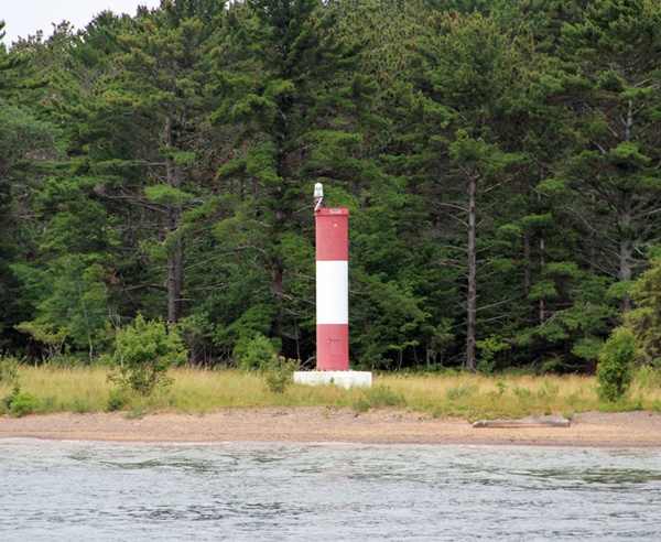
Date unknown (station established 1885). Active; focal plane 15 m (49 ft); white flash every 4 s. 10 m (33 ft) square skeletal tower carrying a square daymark colored with red and white horizontal bands. No photo available but Google has a satellite view. The original lighthouse, a square wood tower, was demolished in the 1950s. Located on a small island on the north side of the channel south of Spanish. Accessible only by boat. Site open, tower closed. ARLHS CAN-057; CCG I-1020.
Mississagi Island (3?)
Date unknown (station established 1884). Active; focal plane 21 m (62 ft); white flash every 4 s. 18 m (59 ft) square skeletal tower, height unknown, carrying a daymark colored with red and white horizontal bands. No photo available but Bing has an indistinct satellite view. The original lighthouse, a square wood tower attached to a keeper's house, burned to the ground in 1948. Anderson has a photo of the skeletal tower that replaced it in 1948, but it's likely that tower has since been replaced by a more modern skeletal tower. Located on an island on the north side of the channel south of Blind River. Accessible only by boat. Site open, tower closed. ARLHS CAN-321; CCG I-1033.
Sulphur Island (2?)
Date unknown (station established 1869). Active; focal plane 18 m (59 ft); white flash every 4 s. 12 m (39 ft) square skeletal tower carrying a daymark colored with red and white horizontal bands. An older photo is available (showing the daymark colored black and white) and Google has a satellite view. The original lighthouse, a square wood tower, was apparently removed in 1968. Located on an island on the south side of the channel opposite Thessalon and off the north coast of Drummond Island (in the U.S.). Accessible only by boat. Site open, tower closed. ARLHS CAN-484; CCG I-1038.
[Thessalon (Thessalon Point) (3?)]
Date unknown (station established 1870). Active; focal plane 9 m (30 ft); white flash every 4 s. 6 m (20 ft) square skeletal mast carrying a daymark colored with red and white horizontal bands. No photo available but Google has a satellite view. The original lighthouse had a lantern atop a 2-story square keeper's house; foundation ruins of the house are seen in the satellite view. Located beyond the end of Lighthouse Point Road at the tip of a sharp point projecting into the North Channel at Thessalon. Site probably open, tower closed. ARLHS CAN-499; CCG I-1049.4.
* McKay Island (1)
1907. Inactive since 1975. Approx. 12 m (40 ft) square cylindrical wood tower with lantern and gallery mounted on the roof of 2-story square wood keeper's house. Lighthouse painted white; lantern roof is red. Frank Post has a 2024 photo is at right, Nicole Gocz an has a 2018 photo, Bash has a photo, Phil Seel has a 2020 photo, and Google has a street view and a satellite view. By the time it was deactivated, the lighthouse was severely deteriorated. Harold Peterson, who owned the rest of the island, purchased the building and restored it. Still owned by the Peterson family, the lighthouse is now available year-round for vacation rental. Located on an island off Bruce Mines on the north side of the channel. The island is accessible by bridges from the mainland via French Island. Site open, lighthouse open only to paying guests. Owner: Canadian Coast Guard. Site manager: Bruce Bay Cottages and Lighthouse . ARLHS CAN-311.
* McKay Island (2)
1975. Active; focal plane 13 m (45 ft); white light, 2 s on, 2 s off. 10 m (30 ft) square skeletal tower carrying a rectangular daymark colored with red and white horizontal bands. Frank Post's photo is at right. Located in front of the historic lighthouse. Site open, tower closed. CCG I-1050.

McKay Island Light, Bruce Mines, August 2024
Google Maps photo by Frank Post
West Sister Rock
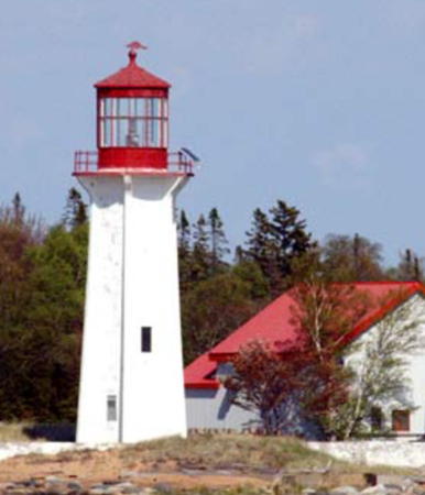
1885 (relocated here in 1905). Active; focal plane 11.5 m (38 ft); white flash every 4 s. 9 m (29 ft) hexagonal wood tower with lantern and gallery, painted white; lantern is red. Dan Ableson's 2022 photo is at the top of this page (he biked across the ice to the lighthouse), Nicholas Fraser has a 2018 photo, and Google has a satellite view. This lighthouse was originally built on North Sister Rock and was relocated in 1905; it guides vessels through a narrow passage west of Portlock Island. Located on a tiny island off the northeast coast of St. Joseph Island. Accessible only by boat. Site and tower closed. Owner/site manager: Canadian Coast Guard. ARLHS CAN-528; CCG I-1054.
Wilson Channel Range Front
1905. Active; focal plane 21 m (69 ft); continuous red light visible only on the range line. 8 m (27 ft) square pyramidal wood tower with lantern and gallery, painted white with red trim and a red vertical stripe on the range line. The range guides "downbound" (eastbound) vessels tunder the Twyning Bridge and into a very narrow passage between the mainland and Wilson Island. A 2025 photo is at right, Bash has a good photo, a 2020 closeup street view is available, and Google has a satellite view. Located beyond the end of Range Lights Road on the north side of the channel east of the ON 548 bridge to St. Joseph Island. Land access blocked by private property. Site and tower closed. Owner/site manager: Canadian Coast Guard. ARLHS CAN-599; CCG I-1055.
Wilson Channel Range Rear
1905. Active; focal plane 35.5 m (117 ft); continuous red light. 9 m (29 ft) square pyramidal wood tower with lantern and gallery, painted white with red trim and a red vertical stripe on the range line. Bash has a photo, a 2025 photo is available, and Google has a satellite view. Located 220 m (240 yd) northeast of the front light, beyond the end of Range Lights Road on the north side of the channel east of the ON 548 bridge to St. Joseph Island. Land access blocked by private property. Site and tower closed. Owner/site manager: Canadian Coast Guard. ARLHS CAN-600; CCG I-1056.

Wilson Channel Range Front Light, St. Joseph Channel, June 2025
Google Maps photo by Orange Zeke

St. Joseph Island Lighthouses
St. Joseph Island is about 30 km (19 mi) long and 20 km (12.5 mi) wide. Access to the island is by the Twyning Bridge on ON 548 at the north end of the island. On the east and north sides it is separated from the Ontario mainland by the St. Joseph Channel. On the west and southwest is the St. Marys River and the main ship channels connecting Lakes Huron and Superior. The river forms part of the boundary between Canada and the United States. Lighthouses on the U.S. side are described on the Eastern Upper Michigan page.

Hay Point Range Front
Date unknown. Active; focal plane 14 m (46 ft); continuous white light. 12 m (39 ft) round cylindrical tower, painted white with an orange vertical stripe. No photo available but Google has a satellite view. This range guides downbound vessels in the St. Marys River through the Munuscong Lake section of the river. Located at Hay Point near the southern end of St. Joseph Island. Probably accessible only by boat. Site open, tower closed. USCG 7-12995; CCG I-1059.6.
Hay Point Range Rear
Date unknown. Active; focal plane 22.5 m (74 ft); continuous white light. 21 m (69 ft) square skeletal tower carrying a daymark colored white with an orange vertical stripe. No photo available but Google has a satellite view. Located 330 m (1000 ft) southeast of the front light. Probably accessible only by boat. Site open, tower closed. USCG 7-13000; CCG I-1059.7.
Rains Wharf Range Rear
Date unknown. Active; focal plane 16.5 m (54 ft); continuous white light. 14 m (46 ft) square skeletal tower carrying a daymark colored white with an orange vertical stripe. Google has a satellite view and a distant 2024 street view. This range guides downbound vessels. The front light is on a mast. Located off ON 548 a short distance south of the Sailors' Encampment Church (next entry). Site open, tower closed. USCG 7-13140; CCG I-1063.
Sailor's Encampment Range Front (2?)
Date unknown (1950s? station established 1892). Inactive. Approx. 20 m (66 ft) square skeletal tower. Google has a 2024 street view and a satellite view. Located about 75 m (250 ft) south of the new front light. Site and tower closed (private property) but the tower can be seen from the street.
* Sailor's Encampment Range Front (3?)
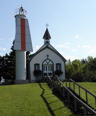
Date unknown (station established 1892). Active; focal plane 19.5 m (64 ft); continuous white light. 12.5 m (41 ft) round cylindrical tower, painted white and carrying a trapezoidal daymark painted white with a red vertical stripe. Google's 2024 street view is at right, Tess Parker posted a 2009 photo, and Google also has a satellite view. This range guides northbound (upbound) vessels in the narrow passage between St. Joseph Island and Neebish Island. The original lighthouse, a square wood tower, was replaced by a skeletal tower in 1959. Located beside ON 548 in front of the historic Sailor's Encampment Church on the northwest side of St. Joseph Island. Site open, tower closed. ARLHS CAN-820; USCG 7-13100; CCG I-1060.

Sailors Encampment Front Light, St. Joseph Island, Sepember 2024
Google Maps street view
Sailors' Encampment Range Rear (2?)
Date unknown (1959? station established 1892). Inactive. Square skeletal tower, unknown height. No photo available but Google has a satellite view. Located about 100 m (110 yd) southeast of the active light (next entry). Site and tower closed (private property).
Sailors' Encampment Range Rear (3?)
Date unknown (station established 1892). Active; focal plane 35 m (115 ft); continuous white light. square skeletal tower carrying a daymark colored white with an orange vertical stripe. No photo available but Google has a satellite view. The original lighthouse, a square wood tower, was replaced by a skeletal tower in 1959. Located 672 m (2200 ft) northeast of the front light. Site and tower closed (private property). ARLHS CAN-821; USCG 7-13105; CCG I-1061.
Stribling Point Range Front (3?)
Date unknown (station established 1902). Active; focal plane 15 m (49 ft); continuous white light. 16 m (52 ft) round cylindrical tower, painted white. The tower is listed with an orange vertical stripe. Google has a satellite view. This range is called an upbound range in both the Canadian and U.S. light lists, but actually it guides downbound vessels in the St. Marys River around the northern end of Neebish Island. The original lighthouse, a square wood tower, was replaced by a skeletal tower in the 1950s. Located at the northwestern point of St. Joseph Island. Probably accessible only by boat. Site open, tower closed. ARLHS CAN-825; USCG 7-13260; CCG I-1064.
Stribling Point Range Front (2?)
Date unknown (1950s? station established 1902). Inactive. Approx. 20 m (66 ft) square skeletal tower. Google has a satellite view. Located about 75 m (250 ft) north of the new front light. Site status unknown.
Stribling Point Range Rear (3?)
Date unknown (station established 1902). Active; focal plane 26 m (85 ft); continuous white light. 12 m (39 ft) round cylindrical tower, painted white. No photo available but Google has a satellite view. The new light was required by a small realignment of the range line. Located 957 m (0.6 mi) east southeast of the front light. Site status unknown. ARLHS CAN-824; USCG 7-13265; CCG I-1065.
Stribling Point Range Rear (2?)
Date unknown (1950s? station established 1902). Inactive. 30 m (98 ft) square skeletal tower. No photo available but Google has a satellite view. Located about 75 m (250 ft) north of the new rear light. Site status unknown.
Shoal Island (2)
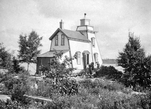
1909 (station established 1884). Active; focal plane 11 m (36 ft); white flash every 4 s. 10.5 m (34 ft) square cylindrical wood tower with lantern and gallery centered on the roof of 2-story wood keeper's house. Lighthouse painted white with red trim. Chuck Hoag's 2022 view from the water is at right, C.M. Hanchey has a 2017 photo, Lighthouse Digest has Michel Forand's photo, Bryan O'Toole has a nice photo, and Google has a satellite view. This light marks a narrow passage at the northwestern corner of St. Joseph Island. The original lighthouse burned in 1909. The current lighthouse is endangered. The Coast Guard declared the building surplus in 2008 with the intention of replacing it with a skeletal tower. The St. Joseph Township Council has expressed its willingness to take ownership of the lighthouse if the Coast Guard will make some needed repairs. Negotiations are continuing. The lighthouse was still active in the summer of 2022. Located on a small island just off the northwest coast of St. Joseph Island; visible from the end of B Line Road near Richards Landing. Accessible only by boat. Site and tower closed. Owner/site manager: Canadian Coast Guard. ARLHS CAN-588; CCG I-1058.
* Richards Landing (3)
2009 (station establishment date unknown). Active; focal plane 8.5 m (28 ft); green flash every 5 s. Approx. 7.5 m (25 ft) square pyramidal tower with lantern and gallery. Lighthouse painted white, lantern and gallery rail red. Google's 2024 street view is at right, Anurag Talati has a 2018 photo, Lori Goheen-Prichard has a 2019 closeup, and Google also has a satellite view. The original light was mounted on the roof of a warehouse on the town wharf; this was replaced in 1940 by a light on a 7 m (23 ft) post. In 2004 retired judge Ray Stortini started a campaign to replace the beacon with a lighthouse; Judge Stortini also contibuted the funds to construct the building. The lighthouse was activated in a ceremony on 30 May 2009. Located on the wharf at Richards Landing, a village on the north shore of St. Joseph Island. Site open, tower closed. CCG I-1057.


Shoal Island Light, St. Joseph, June 2022
Google Maps photo by Chuck Hoag


Richards Landing Light, St. Joseph, September 2024
Google Maps street view


Sault Sainte Marie City (Upper St. Marys River) Lighthouses
The St. Marys River drains Lake Superior into Lake Huron, falling 7 m (23 ft) over its length of 120 km (75 mi). The Soo Locks at Sault Sainte Marie, Michigan manage this elevation difference for vessels. On the Canadian side Sault Sainte Marie, Ontario is a city of about 75,000 residents and the administrative seat of the Algoma District.

Canadian Canal Upper Entrance Range Rear
Date unknown. Active; focal plane 19 m (62 ft); continuous red light. 17 m (56 ft) square cylindrical skeletal tower carrying a red slatted daymark with a white vertical stripe. A photo of the range lights is available and Google has a satellite view. The Canadian Sault Sainte Marie Canal, completed in 1895, is now a national historic site; the lock is in operation but it serves only small craft. Located in the Algoma Steel Plant, on the north side of the river west of the canal entrance. Site and tower closed. Site manager: Algoma Steel. CCG I-1071; USCG 7-14295.
Pointe aux Pins Range Front
1903. Active; focal plane 9 m (30 ft); continuous green light. 8.5 m (28 ft) square pyramidal wood tower, painted white with red trim and a red vertical stripe on the range line. Kelley Neal's 2024 photo is at right, Bash has a 2011 photo, and Google has a satellite view and a distant street view. This is an "upbound" (westbound) range guiding ships around a sharp bend in the river above the Soo Locks. Pointe aux Pins is now known as Pointe Louise. Located on the point, at the end of Pointe Louise Road on the west side of Sault Sainte Marie. Site closed (surrounded by private property), tower closed. Famous Soo Locks Boat Tours has a lighthouse cruise that provides a view of this lighthouse. Owner/site manager: Canadian Coast Guard. ARLHS CAN-889; USCG 7-14325; CCG I-1077.
Pointe aux Pins Range Rear (1)
1903. Inactive since about 1975. 17 m (56 ft) square pyramidal wood tower with lantern and gallery, painted white with red trim, attached to a 1-story wood residence. Google has a satellite view. After deactivation the lighthouse was sold, relocated to private property near its original location, and attached to a residence. The original keeper's house was destroyed. Located near the end of Point Louise Road on the west side of Sault Sainte Marie. Site closed (surrounded by private property), tower closed. Famous Soo Locks Boat Tours has a lighthouse cruise that provides a view of this lighthouse. Owner/site manager: private. ARLHS CAN-890.
Pointe aux Pins Range Rear (3)
2010 (station established 1903). Active; focal plane 19 m (62 ft); continuous green light. 17 m (55 ft) slender triangular steel skeletal tower. The tower carries a trapezoidal slatted daymark painted white with a red vertical stripe. Bash has a photo and Google has a satellite view. Located 280 m (980 ft) southwest of the front light, on the tip of a small peninsula at the end of Harriet Street. Site status unknown. USCG 7-14330; CCG I-1078.

Pointe aux Pins Range Front Light, Sault Sainte Marie, August 2024
ex-Google Maps photo by Kelley Neal
[Pointe aux Pins Main (2)]
1970 (station established 1873). Active; focal plane 8 m (26 ft); red light, 2 s on, 2 s off. 7 m (23 ft) round cylindrical Claymar tower painted red with a white horizontal band. Anderson has Craig Hanchey's photo and Google has a satellite view. The original lighthouse, a square wood tower, was replaced in 1970. Site and tower closed (private property). ARLHS CAN-888; USCG 7-14370; CCG I-1079.

Southeastern Lake Superior Lighthouses
Gros Cap Reef
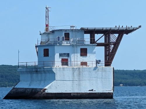
1953 (lightship station established 1923). Active; focal plane 18 m (59 ft); red flash every 5 s. 18 m (60 ft) structure: the light is displayed from a skeletal mast mounted on the roof of a 3-story keeper's quarters. Lighthouse painted white with red trim. The lighthouse also carries a helipad and a tall triangular radio mast. Kelley Neal's 2024 photo is at right, Dan Cravotta has a closeup photo, Tim Lowe has a 2022 closeup, Rob Fekete has a distant view, Marinas.com has aerial photos, and Bing has an indistinct satellite view. The lighthouse is mounted on a concrete crib that has a knife-edge similar to a ship's prow pointed northwest; this design splits ice floes in the winter. Located on the southwest edge of the reef guarding the entrance to the river from Lake Superior. Accessible only by boat; Famous Soo Locks Boat Tours has a lighthouse cruise that provides a view of this lighthouse and there is a distant view from the Point Iroquois lighthouse in the U.S., 4 km (2.5 mi) to the south. Owner/site manager: Canadian Coast Guard. ARLHS CAN-565; USCG 7-14495; CCG I-1081.

Gros Cap Reef Light, Sault Sainte Marie, August 2024
Google Maps photo by Kelley Neal
Île Parisienne
1912. Active; focal plane 16 m (53 ft); white flash every 10 s. 9 m (30 ft) hexagonal concrete tower with lantern and gallery, painted white; lantern is red. The two keeper's houses are staffed in season as the initial contact for eastbound vessels entering the Soo Traffic Control Area. Nathan Dunn's has a 2021 view from the lake is at right, Kelley Neal has a 2024 view, Wikimedia has a view from the lake, Bash has a photo, Marinas.com has aerial photos, and Google has a satellite view of the station. Île Parisienne is an uninhabited 900 ha (2200 acre) island in Whitefish Bay southeast of Whitefish Point, Michigan, and northwest of the entrance to the St. Marys River. Most of the island is wilderness included in the Île Parisienne Conservation Reserve; a 46 ha (114 acre) tract at the southeast corner is privately owned. Lighthouse located at the southwest corner of the island. Accessible only by boat. Site and tower closed. Owner/site manager: Canadian Coast Guard. ARLHS CAN-567; USCG 7-14510; CCG I-1082.
* Corbeil Point (2)
1931 (station established 1873). Inactive since 1961. Square cylindrical wood tower mounted on the roof of 2-story wood keeper's quarters. Lantern removed. Beth McIntyre has a photo and Google has a satellite view. The original lighthouse was replaced after being struck by lightning in the fall of 1930. In 1967 the light station property was ceded to the original landowners, the Batchewana First Nation of Ojibways; they administer it as the Obadjiwan 15E Reserve. The lighthouse was then designated as the residence of the hereditary chief, currently Joe Tom Sayers. Located on a prominent cape at the west side of the entrance to Batchawana Bay, about 3 km (2 mi) southwest of the town of Batchawana Bay. Accessible by road. Site open, tower closed. Owner/site manager: Batchewana First Nation. ARLHS CAN-1028.
* Coppermine Point
1910. Inactive since the 1960s. Approx. 9 m (30 ft) square pyramidal frame tower with lantern and gallery, painted white with red trim; lantern and gallery are red. Bash has a photo, Michele Maki also has a photo, and Google has a 2024 street view and a fuzzy satellite view. Gravely endangered; an October 2018 photo and Maureen Hutchinson-Parker's 2022 photo show the poor condition of the lighthouse. Originally located on the cape, about 20 km (13 mi) northwest of Batchawana Bay; it was replaced there by a small post light (CCG I-1087). After deactivation the lighthouse was sold and relocated to a restaurant and campground at Hibbard Bay, about 3 km (2 mi) to the north. These businesses are now closed but the lighthouse still stands beside the Trans-Canada Highway (ON 17) about 85 km (53 mi) north of Sault Sainte Marie. Site open, tower closed. Owner/site manager: private. ARLHS CAN-147.

Île Parisienne Light, Lake Superior, May 2021
Google Maps photo by Nathan Dunn
[Gargantua (3)]
1980 (station established 1889). Active; focal plane 24 m (79 ft); white flash every 4 s. 5 m (17 ft) mast carrying a red and white daymark. No photo available but Bing has a distant satellite view. Gargantua is a former logging and fishing harbor on the central east coast of Lake Superior. The village has been abandoned at least since the 1960s. The original lighthouse, a hexagonal wood tower, was replaced by a skeletal tower in 1949 and then by the mast in 1980. Located on the summit of the island, in the entrance to the harbor. Accessible only by boat. Site open, tower closed. Site manager: Lake Superior Provincial Park. ARLHS CAN-1066; CCG I-1091.

Wawa Township Lighthouse
Michipicoten Harbour (2)
1967 (station established 1902). Active; focal plane 27 m (89 ft); white flash every 10 s. 12.5 m (41 ft) square pyramidal steel skeletal tower. Several Coast Guard station buildings. Fog horn (two 3 s blasts every 60s) on request. A closeup snapshot is available and Google has an indistinct satellite view. The original lighthouse, a square wood tower, was demolished after being deactivated. Located on Perkwakwia Point about 10 km (6 mi) west of Michipicoten and 25 km (15 mi) west of Wawa, at the extreme northeastern corner of Lake Superior. Site status unknown. Owner/site manager: Canadian Coast Guard. ARLHS CAN-1318; USCG 7-16855; CCG I-1093.

Information available on lost lighthouses:

Notable faux lighthouses:

Adjoining pages: Southeast: West Central Ontario | South: USA: Eastern Upper Michigan | West: Northwestern Ontario

Return to the Lighthouse Directory index | Ratings key

Posted December 16, 2003. Checked and revised September 28, 2025. Lighthouses: 30. Site copyright 2025 Russ Rowlett and the University of North Carolina at Chapel Hill.