Lighthouses of Canada: Eastern Prince Edward Island

The nation of Canada was created by the British North America Act in 1867 with Ontario, Québec, New Brunswick, and Nova Scotia as the four original provinces. The area had been part of New France, the French empire in North America, which fell to Britain during the Seven Years War (1756-63). Prince Edward Island, previously called Île Saint-Jean under French rule, was initially assigned to the Nova Scotia colony, but it became a separate colony in 1769. The colony's name was changed from St. John's Island to Prince Edwrad Island in 1798. The island declined to join the Confederation in 1867 but joined in 1873 after several years of negotiation.

Smallest of the ten Canadian provinces, Prince Edward island is located in the southern part of the Gulf of St. Lawrence, separated from the mainland by the Northumberland Strait. The island is readily accessible by the Confederation Bridge from Cape Jourimain, New Brunswick, or in the summer by car ferry from Caribou, Nova Scotia.

The province is divided into three counties, although the counties no longer have any governmental functions. This page lists lighthouses of the central and eastern portions of the island in Queens County and Kings County, respectively. There's another page for Western Prince Edward Island.

The Prince Edward Island Lighthouse Society works for the preservation of the island's light stations.

Aids to navigation in Canada are maintained by the Canadian Coast Guard. In 2008 Parliament passed the Heritage Lighthouse Protection Act (HLPA) to designate and protect historic lighthouses.

Special thanks to Kelly Ann Loughery for sharing her extensive knowledge of Prince Edward Island lighthouses and her large collection of photos.

ARLHS numbers are from the ARLHS World List of Lights; CCG numbers are from the Atlantic Coast volume of the List of Lights, Buoys, and Fog Signals of Fisheries and Oceans Canada; Admiralty numbers are from Volume H of the Admiralty List of Lights & Fog Signals; and U.S. NGA numbers are from Publication 110, Atlantic Coast of the Americas. Unless noted otherwise, all active lights are owned and operated by the Canadian Coast Guard.
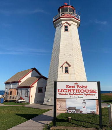
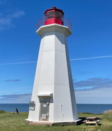
East Point Light, Souris, September 2022
Instagram photo by East Point Lighthouse
General Sources
Prince Edward Island Lighthouse Society
Information for all of the island's lighthouses.
Prince Edward Island Lighthouses
Photos and information posted by Kraig Anderson.
Seldom-Seen Lighthouses of Prince Edward Island
Photos contributed by Kelly Anne Loughery.
Lighthouses of Prince Edward Island
Photos by various photographers available from Wikimedia.
Online List of Lights - Prince Edward Island
Photos by various photographers posted by Alexander Trabas. Photos for Prince Edward Island are by Michael Boucher and Klaus Potschien.
World of Lighthouses - Prince Edward Island
Photos by various photographers available from Lightphotos.net.
Prince Edward Island, Canada Lighthouses
Aerial photos posted by Marinas.com.
Leuchttürme Kanadas auf historischen Postkarten
Historic postcard views posted by Klaus Huelse.
List of Lights, Buoys, and Fog Signals
Official light lists from the Canadian Coast Guard.
GPSNauticalCharts
Navigational chart information for Prince Edward Island.
Navionics Charts
Navigational chart for Prince Edward Island.

Cape Tryon Light, French River, August 2018
Wikimedia Creative Commons photo by William Li

Queens County North Coast Lighthouses

Cape Tryon (1) (relocated)
1905. Inactive since 1969. Approx. 11 m (36 ft); lantern and gallery mounted at one end of a 2-story wood keeper's house. Building painted white with red trim; lantern painted red. Lighthouse Digest has Michel Forand's photo, Kelly Anne Loughery has a photo, a distant view is available, Timothy Flanders has a distant street view from the beach, and Google has a satellite view. The original Cape Tryon lighthouse has been relocated three times since it was deactivated in 1969. Nicely restored, it is in use as a summer residence by the Somers family. Located at Cousins Shore about 4 km (2.5 mi) west of the cape. The surrounding land is private but Kelly Anne Loughery reports that the lighthouse can be viewed by parking at the end of Cousins Shore Road and walking a short distance up Lighthouse Road. Site and tower closed. Owner/site manager: private. ARLHS CAN-771.
Cape Tryon (2)
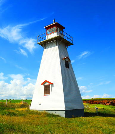
1969. Active; focal plane 35 m (115 ft); white light, 2 s on, 4 s off. 12 m (39 ft) square pyramidal shingled tower with lantern and gallery, painted white with red trim; lantern roof is red. William Li's photo is above, Alan Culley has a 2007 photo, Trabas has Boucher's photo, Stephen Peacock has a 2019 closeup, Ian MacNeill has a street view, and Google has a satellite view. The lighthouse is endangered by erosion of the cliff on which it stands; its situation can be seen in aerial photos from Marinas.com. Located on a farm atop a cliff north of French River; accessible by a private dirt road. In July 2014 the landowner closed the road to vehicles but visitors are welcome to walk the 1 km (0.6 mi) to the lighthouse as long as they respect private property. The lighthouse was repainted and refurbished in 2018. Site open, tower closed. Owner: Canadian Coast Guard. Site manager: private. . ARLHS CAN-113; CCG A-1061; Admiralty H1129; NGA 7948.
* New London (Range Rear) (Yankee Hill)
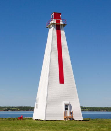
1876. Active; focal plane 13 m (43 ft); white light, 2 s on, 2 s off. 12 m (40 ft) square pyramidal shingled tower with lantern and gallery, rising from one half of a 1-1/2 story keeper's house. Lighthouse painted white with red trim; vertical red stripe marks the range line. Michael McDonald's 2022 photo is at right, a 2007 closeup is available, Trabas has Boucher's photo, Robert Hiscock has a good 2005 photo, Marinas.com has aerial photos, and Google has a street view and a distant satellite view. There was a pair of small range lights here in 1874. The range was discontinued in 2006 and the front range light was removed. The lighthouse is leased as a private residence and the occupants have applied for ownership. Located at the eastern end of the Cape Road north of French River, marking the west side of the entrance to Rustico Harbour. Site open, tower closed. Owner: Canadian Coast Guard. Site manager: private. ARLHS CAN-341; CCG A-1060.01; Admiralty H1130.05; NGA 7956.

New London Range Rear Light, Kensington, July 2022
Google Maps photo
by Michael McDonald
* North Rustico Harbour (2)
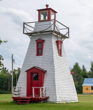
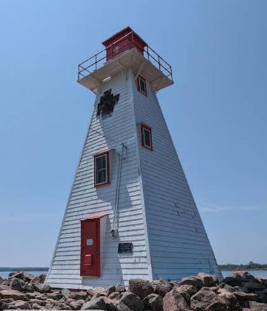
1899 (station established 1876). Reactivated (inactive 1973-76); focal plane 12.5 m (41 ft); yellow light, 5 s on, 5 s off. 10 m (34 ft) square pyramidal wood tower with lantern and gallery, rising from one half of a 1-1/2 story keeper's house. Lighthouse painted white wth dark red trim; lantern is bright red. Renan Dante Straccia's 2023 photo is at right, another excellent photo is available, Trabas has Boucher's photo, Wikimedia has Dylan Kereluk's photo, Randy Gardner has a good photo, Marinas.com has aerial photos, and Google has a street view and a satellite view. A very well maintained little lighthouse. The light was moved to a skeletal tower in 1973 but in response to local protests the Coast Guard returned it to the lighthouse in 1976. The Friends of North Shore Communities applied for ownership with the intention is to renovate the building for overnight accommodations. The Coast Guard was willing to transfer the lighthouse but the deal was held up by a dispute with a neighboring landowner. This effort appears to have failed. Located off PE 6 in the center of the town of North Rustico. Site open, tower closed. Owner/site manager: Canadian Coast Guard. . ARLHS CAN-350; CCG A-1056; Admiralty H1141; NGA 7972.
* Covehead Harbour (Cape Stanhope) (2)
1976 (station established 1967). Active; focal plane 10 m (33 ft); white flash every 5 s. 8 m (27 ft) square pyramidal wood tower with lantern and gallery, painted white with red trim; lantern is red. Fresnel lens in use. Fog horn (maintained by local harbor authority, blast every 30 s). Lighthouse Digest has Terry D'Entremont's photo, Trabas has Potschien's closeup photo, Taljit Singh Gill has a 2021 photo, another fine photo is available, Marinas.com has aerial photos, and Google has a street view and a satellite view. The siding on the lighthouse was replaced in 1994. The preservation group Friends of Covehead Lighthouse applied for ownership and in 2015 the group's application was accepted. The transfer of ownership has probably occurred. In February 2018 the lighthouse was featured on a new postage stamp. Located just off the Gulf Shore Parkway on the cape north of Stanhope, marking the entrance to Covehead Bay. Parking is provided. Site open, tower closed. Owner/site manager: Friends of Covehead Lighthouse and Parks Canada (Prince Edward Island National Park). . ARLHS CAN-150; CCG A-1051; Admiralty H1150; NGA 7996.

North Rustico Harbour Light, North Rustico, January 2023
Google Maps photo by Renan Dante Straccia

Kings County Lighthouses

North Coast Lighthouses
* St. Peters Harbour (2)
1881 (station established 1865). Inactive since the spring of 2008. Approx. 8 m (27 ft) square pyramidal wood tower with lantern and gallery, painted white with red trim; lantern is black. Kevin Journeau has a 2022 photo, Dan Watson has a fine 2020 photo, Lighthouse Digest has Michel Forand's photo, Marinas.com has aerial photos, and Google has a satellite view. The lighthouse marks the entrance to St. Peter's Bay. A local group applied for ownership and received the deed to the lighthouse in February 2017. They acted immediately to repaint and refurbish the tower in the summer of 2017. Juju Wang's 2016 street view shows the lighthouse before its restoration. The lighthouse received federal heritage designation in September 2016. Located at the end of a dirt road at the west side of the entrance to St. Peters Bay. Anderson says that the last section of the road is generally impassable but one can walk the rest of the way. Kelly Ann Loughery reports that the best access is by parking at the end of St. Peters Harbour Road and walking east on the beach about 1 km (2/3 mi) to the lighthouse. Site open, tower closed. Owner/site manager: St. Peters Harbour Lighthouse Society . ex-CCG A-1044; ex-Admiralty H1164; ex-NGA 8032.
* [Shipwreck Point (Naufrage) (1)]
1913. Inactive since 1968. 2-story square wood keeper's house, painted white. Lantern removed. Kelly Anne Loughery has a photo, Marinas.com has aerial photos, and Google has a street view and a satellite view. The house has been in use as a private residence; it was sold in 2013 and the new owners renovated it as a vacation cottage. It's unclear if it's still available for rental. Located a short distance east of the current lighthouse. Site and tower closed (private property) but the lighthouse can be seen from a short distance away behind the Shipwreck Point Café. Owner/site manager: private.
* Shipwreck Point (Naufrage) (2)
1968 (station established 1913). Active; focal plane 25.5 m (84 ft); white light, 3 s on, 2 s off. 13.5 m (44 ft) octagonal concrete tower with lantern and gallery, painted white; lantern is red. Marie-Claude Paquette's photo is at right, Trabas has Boucher's photo, Toby Clark has a 2021 photo, Doug Leitch has a wintertime closeup, Marinas.com has aerial photos, and Google has a street view and a satellite view. Naufrage is the French word for a shipwreck. In 2015 a local group applied for ownership of the lighthouse; as of July 2021 they were still waiting for the transfer. In 2017 the group received a grant of $28,540 for repairs to the lighthouse. In the fall of 2021 DFO repainted the lighthouse, but the paint began peeling within months and DFO exerted its warranty for another painting. Located off PE 16 at Naufrage Harbour. Site and tower closed (private property) but the lighthouse can be seen from a short distance away behind the Shipwreck Point Café. Owner: Canadian Coast Guard. Site manager: Friends of Shipwreck Point . ARLHS CAN-459; CCG A-1042. Admiralty H1168; NGA 8036.

Shipwreck Point Light, Souris, August 2023
Google Maps photo by Marie-Claude Paquette

East Point (Souris Area) Lighthouses
**** East Point
1867. Active; focal plane 30.5 m (100 ft); white flash every 5 s. 19.5 m (64 ft) octagonal wood tower with lantern and gallery, painted white with red trim; lantern is red. The former fog signal building is now used as a visitor center and gift shop; a modern dwelling (1965) is staffed by the Coast Guard.A 2022 photo is at the top of this page, Anderson's page has good photos, Douglas Sprott has a good photo, Corey Balazowich also has a good photo, Ketan Raval has a 2020 photo, Jenn Calder has a 2010 closeup, Trabas has Boucher's closeup photo, Marinas.com has aerial photos, Huelse has a historic postcard view, and Google has a closeup street view and a distant satellite view. One of the island's most popular tourist attractions. The lighthouse was relocated closer to the water in 1885 and then returned to its original site in 1908 when threatened by erosion. Erosion is a continuing problem and in the spring of 2008 the fog signal/visitor center building was relocated next to the tower to escape the waves. In 2009 DFO transferred ownership of the station to Friends of Elmira, a local preservation group. In August 2010 the group and the provincial government also completed at $250,000 program of improvements to the site, including enlarged visitor facilities. In 2016 the friends group received $54,375 in grants, mostly from the federal and provincial governments, for exterior and interior restoration of the light tower. Located at the easternmost point of the island off PE 16 northeast of Souris. Accessible by paved road; parking provided. Site open; tower open from June through September. Owner/site manager: Friends of Elmira, Inc. (East Point Lighthouse ). ARLHS CAN-165; CCG A-943; Admiralty H0920; NGA 8072.
*** Souris East (Knight Point)
1880. Active; focal plane 27 m (89 ft); white light, 2 s on, 2 s off. 14 m (46 ft) square pyramidal wood tower with lantern and gallery, painted white with red trim; lantern is red. 1-story fog signal building. Dan Darling's photo is at right, Po Wang Chow has a 2011 closeup photo, Trabas has Boucher's closeup photo, a 2021 drone view is available, Jordan Rideout has a 2021 sunset photo of the light in action, Marinas.com has aerial photos, Google has a distant street view, and Bing has a satellite view. In 2009-10 the Souris Harbour Authority took ownership and restored the lighthouse, aided by a $50,000 grant from the Atlantic Canada Opportunities Agency. The lighthouse opened to the public in July 2010; an interpretive center and gift shop was added, and the original 4th order Fresnel lens is on display. Located on Knight Point in Souris. Site open, tower open daily June through October. Owner/site manager: Souris Harbour Authority (Souris Historic Lighthouse ). ARLHS CAN-465; CCG A-947; Admiralty H0922; NGA 8084.

Souris East Light, Souris, October 2016
Flickr Creative Commons photo by Dan Darling

Annandale Lighthouses
* Annandale Sector (former Range Front) (2)
1990 (station established 1898). Active; focal plane 9 m (30 ft); continuous red, white or green light depending on direction. 5 m (17 ft) square pyramidal shingled tower, painted white, originally with a red vertical stripe. No lantern: the light is displayed through a small opening near the top of the tower. Ryan Xu has a winter 2021 photo, Lighthouse Digest has Carol Livingstone's closeup photo, another closeup photo is available, Trabas has Boucher's closeup photo, and Google has a street view and a satellite view. This was formerly the front light of the Annandale Range; it was converted to a sector light in 2015. No one has applied for ownership of this lighthouse. Located off PE 310 on Banks Point at Annandale Harbour. Site open, tower closed. Owner/site manager: Canadian Coast Guard. ARLHS CAN-011; CCG A-949.5; Admiralty H0928; NGA 8092.
Annandale Range Rear (2)
1901 (station established 1898). Inactive since 2015. 20 m (66 ft) square pyramidal shingled tower with lantern and gallery, painted white formerly with with a red vertical stripe. A 2022 photo is at right, Lighthouse Digest has Carol Livingstone's closeup photo, a 2011 photo is available, Ryan Xu has a 2021 photo, Marinas.com has aerial photos, Google has a street view, and Bing has a satellite view. This is the second-tallest lighthouse on the island, standing nearly a mile northwest of the front range tower. Originally it was a skeletal tower, but it was enclosed in 1905. The lighthouse was long endangered by beach erosion, but in early 2020 DFO moved it inland about 30 m (98 ft) from the beach. The lighthouse was also turned so that its vertical red stripe now faces the land. Members of the Norton family formed a new organization to work for restoration and ownership. In October 2020 the lighthouse was added to the list of Heritage Lighthouses. In 2022 the lighthouses opened as an Airbnb overnight rental. Located off PE 310 on Juniper Point at Annandale Harbour. Site and tower closed (private property), but the light can be seen from a distance of about 400 m (1/4 mi). Owner/site manager: Canadian Coast Guard (?). Site manager: Annandale Lighthouse . ARLHS CAN-012; ex-CCG A-950; ex-Admiralty H0928.1; ex-NGA 8096.
Annandale Range Front (1) (relocated)
1898. Inactive since 1990. 5 m (17 ft) square pyramidal shingled tower, painted white with a red vertical stripe. No lantern: the light was displayed through a small opening near the top of the tower. Kelly Anne Loughery has contributed a photo and Google has a satellite view. The lighthouse was sold and relocated in 1991 to private property a short distance west of the current rear range light; it can be seen in Marinas.com aerial photos. Located off PE 310 on Juniper Point at Annandale Harbour. Site and tower closed (private property), but the light can be seen from a distance of about 400 m (1/4 mi). Owner/site manager: private.

Annandale Range Rear Light, Montague, June 2022
Instagram photo by Annandale Lighthouse Inc.

Georgetown Area Lighthouses
* Cardigan River (Range Rear) (relocated)
1883. Inactive since the early 1980s. 10 m (33 ft) square wood tower with lantern and gallery, painted white with red trim; lantern is red. Reed Radcliffe has a 2022 photo, Chandu Andhe has a photo, and Google has an indistinct satellite view. The lighthouse became the rear light of the Cardigan River Range in 1926. In 1967 a directional light was installed and the front light was discontinued. After all lights were discontinued in the early 1980s the lighthouse was purchased by Paul and Rosemary Batchilder and moved about 300 m (1000 ft) west to its present location in a summer cottage development. The present owner is their daughter Melissa. Located at the end of Morrison's Beach Road north of Georgetown. Site status uncertain; the entrance to the cottage development is open. Owner/site manager: private. ARLHS CAN-1254; ex-Admiralty H0946.
* Georgetown (Wightman's Point, St. Andrews Point) Range Rear (2)
1890 (station established 1877). Inactive since 2017. 13 m (43 ft) square pyramidal wood tower with lantern and gallery, painted white with a red vertical stripe on the range line. Paul Ratha Yem has a 2017 photo, Sandeep Bharadwaj has a 2019 photo, Lighthouse Digest has Carol Livingstone's photo, Marinas.com has aerial photos, and Google has a satellite view. No one applied for ownership of this lighthouse, but since it has been deactivated it is likely to be transferred to the private landowners. Located on Wightmans Point Road in Lower Montague. Site and tower closed (private property), but the lighthouse is easily seen from the road. Site manager: Canadian Coast Guard. ARLHS CAN-196; ex-CCG A-956; ex-Admiralty H0936.1; ex-NGA 8116.
* Georgetown (Wightman's Point, St. Andrews Point) Range Front (1) (relocated)
1868. Inactive since 1969. Approx. 9 m (30 ft) square wood lantern and gallery centered on the roof of a square 1-story wood keeper's house. Lighthouse painted white with red trim. Kelly Anne Loughery has contributed the photo at right and Google has a satellite view. After deactivation, the lighthouse was relocated as a private residence. As the photo shows, it has been altered somewhat from its original appearance. Located on Wightman's Point (St. Andrews Point) on St. Andrews Point Road on the south side of the entrance to Cardigan Bay. Site and tower closed, but the lighthouse can be seen from nearby. Owner/site manager: private. ARLHS CAN-1388.
[Georgetown (Wightman's Point, St. Andrews Point) Range Front (2)]
1969 (station established 1868). Inactive since 2017 and apparently removed. 7.5 m (25 ft) cylindrical fiberglass tower, painted red with a white horizontal band; no lantern. There are many lights of this style in Canada but this was the only one in Prince Edward Island. The light is not seen in Bing's satellite view. Located on a very sharp point of land projecting into the mouth of the Cardigan River estuary at Lower Montague, near Georgetown. Site open, tower closed. Owner/site manager: Canadian Coast Guard. ARLHS CAN-195; ex-CCG A-955; ex-Admiralty H0936; ex-NGA 8112.
Georgetown Range Front Right
1868 Georgetown Range Front Light
photo copyright Kelly Anne Loughery
used by permission

Panmure Island Lighthouse
*** Panmure Head (Panmure Island)
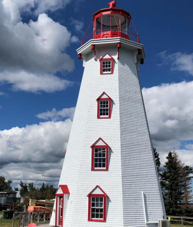
1853. Active; focal plane 25 m (82 ft); white flash every 4 s. 18.5 m (61 ft) octagonal wood tower with lantern and gallery, painted white with red trim; lantern is red. Fog signal building (1908) and modern dwelling (1958) used as a private residence. A 2023 photo is at right, Quoc Phan has a 2021 closeup photo, Lighthouse Digest has Alan Culley's photo, Bill MacKinnon has a fine closeup, Trabas has Boucher's closeup photo, Jimmy Emerson has a good photo, Marinas.com has aerial photos, and Google has a street view and a satellite view of the station. This is the island's oldest wood lighthouse. In 2011 the Panmure Island Lighthouse Association was formed to work for the preservation of the lighthouse; the association applied for ownership. In 2015 volunteers began work to restore the lighthouse, and ownership was transferred in December. An $80,000 grant that came with ownership was used in 2016 to repaint and restore the lighthouse. There is a small gift shop on the ground floor of the tower. Located on PE 347 on Panmure Island at the southwest entrance to Cardigan Bay, within the borders of Panmure Island Provincial Park; accessible by paved road over a causeway. Site open; gift shop and tower open daily June 29 through September 30. Owner/site manager: Panmure Island Lighthouse Association . ARLHS CAN-363; CCG A-953; Admiralty H0932; NGA 8108.

Murray River Lighthouses
* Douse Point Range Front
1898. Inactive since 1984. 5 m (16 ft) square pyramidal wood tower; the light was shown through a square window. Lighthouse painted white. Anderson has a page for the lighthouse, Google has a street view, and Bing has a satellite view. Endangered by lack of maintenance. Originally located on Douse Point, on the east side of the entrance to Orwell River from Hillsborough Bay. The two range lights were sold and relocated to private property in Murray River, about 20 km (13 mi) southeast of the original location. Site and tower closed but the lighthouse stands beside Gladstone Road and can be viewed without trespassing. Owner/site manager: private. ARLHS CAN-1255; ex-Admiralty H0888.
Douse Point Range Rear
1898. Inactive since 1984. 7 m (23 ft) square pyramidal wood tower; the light was shown through a square window. Lighthouse painted white. Anderson has a page for the lighthouse and Bing has a satellite view. Endangered by lack of maintenance. Originally located on Douse Point, on the east side of the entrance to Orwell River from Hillsborough Bay. The two range lights were sold and relocated to private property in Murray River, about 20 km (13 mi) southeast of the original location. This lighthouse is farther from Gladstone Road than the front light and may not be visible from the highway. Site and tower closed. Owner/site manager: private. ARLHS CAN-1256; ex-Admiralty H0888.1.

Panmure Head Light, Panmure Island, May 2023
Instagram photo by Panmure Island Lighthouse

Cape Bear and Murray Harbour Area Lighthouses
Murray Harbour Range Rear (2)
1879 (station established 1869). Active; focal plane 17.5 m (58 ft); continuous red light, visible only on the range line. 14 m (45 ft) square pyramidal wood tower with lantern and gallery, painted white with a red lantern and a vertical red stripe marking the range line. Trabas has Boucher's closeup photo, Lighthouse Digest has Carol Livingstone's photo, Marinas.com has aerial photos, Google has a very distant street view from Wharf Lane east of the lighthouse, and Bing has a satellite view. A local group has applied for ownership of the lighthouse. Located about 1.5 km (almost a mile) southwest of the front range light, in a field on private property. Best viewed from the Beach Point Wharf in Murray Harbour. Site and tower closed. Site manager: Canadian Coast Guard. ARLHS CAN-329; CCG A-965; Admiralty H0954.1; NGA 8144.
* Murray Harbour Range Front (Murray Head, Beach Point) (2)
1879 (station established 1869). Reactivated (inactive 2010-11); focal plane 6.5 m (21 ft); continuous red light, visible only on the range line. 6 m (20 ft) square pyramidal wood tower with lantern, painted white with red trim and a vertical red stripe marking the range line. Lighthouse Digest has Michel Forand's photo, Mitch White has a 2019 closeup, a view from the water is available, Trabas has Boucher's distant view, Marinas.com has aerial photos, and Bing has an indistinct satellite view. Endangered. In December 2010 a powerful storm swept this highly-exposed little lighthouse off its foundation and into the water. The Coast Guard retrieved the tower and left it lying on its side on the beach. Residents formed the Beach Point Lighthouse Society and petitioned for its restoration. Fisheries and Oceans Minister Gail Shea directed the Coast Guard to restore the light, and with the help of a crane it was mounted on a new foundation on 27 July 2011. The Society has applied for ownership of the light. A 2021 photo by Arash Ghashghaei shows the light in immediate need of repainting. Located at Beach Point in Murray Harbor, off PE 18. Site open (accessible at low tide, but the approach over sand is underwater at high tide); tower closed. Site manager: Canadian Coast Guard. ARLHS CAN-328; CCG A-964; Admiralty H0954; NGA 8140.
**** Cape Bear (relocated)
1881. Inactive since 2011. 12 m (40 ft) square pyramidal wood tower with lantern and gallery, painted white; lantern is red. The formerly attached 1-story wood annex was a replica (1999) of the Marconi Radio Station that operated here from 1905 to 1922; the original radio station was relocated to Guernsey Cove as a private residence. A photo is at right, Quoc Phan has a 2021 photo, Rocco Rampino has a good photo, and Google has a satellite view. For many years the lighthouse was gravely endangered by beach erosion. C.M. Hanchey has a good 2007 photo of the lighthouse at its original location, Lorraine Rainey has an excellent closeup, Marinas.com has aerial photos, and Bing has a satellite view. Beginning in 2009 the Northumberland Community Development Corporation negotiated with DFO and the Coast Guard to take ownership of the lighthouse and move it from the exposed cape. In May 2011 the active light was moved from the lighthouse to a small skeletal tower nearby (focal plane 16.5 m (54 ft); yellow light, 2 s on, 4 s off). Trabas has Boucher's photo of the new light. In 2013 the lighthouse was closed due to the erosion threat and 48 hectares (119 acres) of land was purchased as a new home for the lighthouse. Just before Christmas 2014 the lighthouse was moved 30 m (100 ft) to escape imminent danger of collapse; in April 2015 it was moved another 400 m (1300 ft) to its new location. Dennis Jarvis has an October 2015 photo taken shortly after the move and before the lighthouse was restored. Located at the southeasternmost point of the island; the entrance is on Black Brook Road just off PE 18. Site open, tower open daily July through September. Owner: Northumberland Development Corporation. Site manager: Cape Bear Lighthouse and Marconi Station . ARLHS CAN-092. Active light: CCG A-971; Admiralty H0950; NGA 8156.

Cape Bear Light, Murray Harbour, August 2017
ex-Google Plus photo by Terri Travels

Queens County South Coast Lighthouses

Wood Islands Lighthouses
**** Wood Islands
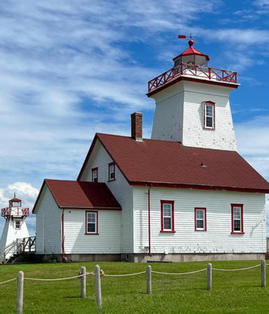
1876. Active; focal plane 22 m (72 ft); white light, 5 s on, 5 s off. 16 m (52 ft) square pyramidal wood tower with lantern and gallery, rising from one end of a 1-1/2 story wood keeper's house. Building painted white with red trim; lantern and keeper's house roof are red. The keeper's house is used as a crafts shop and visitor center. Paula Soler Moya's 2023 photo is at right, Trabas has an excellent photo by Boucher, Lighthouse Digest has Michel Forand's photo, Scott Baltjes has a good closeup, C.M. Hanchey's photo Chris Wilkinson has a 2021 photo showing all three Wood Islands lighthouses, Google has a street view, and Bing has a satellite view. On 10 March 2008 the lighthouse was relocated 70 m (230 ft) inland to avoid beach erosion and in 2009 it was transferred to local ownership. Located adjacent to the ferry terminal at Wood Island, at the end of Wood Islands Park Road. Site open, tower open to guided tours early June through late September. Owner/site manager: Wood Islands and Area Development Corporation (Wood Islands Lighthouse) . ARLHS CAN-535; CCG A-976; Admiralty H0962; NGA 8164.
* Wood Islands Harbour Range Front (relocated)
1902. Inactive since 2007. 6 m (19 ft) square cylindrical wood tower with lantern, rising from a 1-story square wood utility building. Lighthouse painted white with a red vertical stripe on the range line; roofs are dark red. This lighthouse is on the left in Chris Wilkinson's 2021 photo and in the center of Markus Gregory's 2014 photo, Google has a street view, and Bing has a satellite view. The lighthouse was formerly located at the end of the east breakwater of the harbor; Lighthouse Digest has Michel Forand's photo and C.M. Hanchey also has a photo of the lighthouse on the pier. The range was discontinued in 2007 and in 2013 the lighthouse was relocated to a position close to the Wood Islands Lighthouse. Site open, tower closed. Owner/site manager: Wood Islands and Area Development Corporation. ARLHS CAN-536; ex-CCG A-973; ex-Admiralty H0964; ex-NGA 8168.
* Wood Islands Harbour Range Rear (relocated)
1902. Inactive since 2007. 10 m (32 ft) square pyramidal wood tower with lantern and gallery, painted white with red trim and a red vertical stripe on the range line. This lighthouse is on the left in Paula Soler Moya's photo at right, on the right in Chris Wilkinson's 2021 photo, and on the left in Markus Gregory's 2014 photo, Ardalan Shahgholi has a street view, and Bing has a satellite view. The lighthouse was formerly located on the east breakwater of the harbor about 150 m (500 ft) north of the front range light; Lighthouse Digest has Michel Forand's photo and Shane MacClure also has a photo showing both range lighthouses in their original positions. The range was discontinued in 2007 and in 2013 the lighthouse was relocated to a position close to the Wood Islands Lighthouse. Wikimedia has Markus Gregory's 2014 photo of the three lighthouses. Site open, tower closed. Owner/site manager: Wood Islands and Area Development Corporation. ARLHS CAN-537; ex-CCG A-974; ex-Admiralty H0964.1; ex-NGA 8172.

Wood Islands Light, August 2023
Instagram photo by Paula Soler Moya

Point Prim Lighthouse
**** Point Prim (Prim Point)
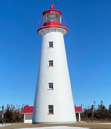
1846 (Isaac Smith). Active; focal plane 21 m (68 ft); white flash every 5 s.18 m (60 ft) brick tower with lantern and gallery, painted white with red trim; lantern and gallery painted red. A 2023 photo is at right, Anderson has a fine page for the lighthouse, Trabas has Potschien's closeup photo, Lighthouse Digest has Alan Culley's photo, a 2019 closeup photo and another excellent closeup photo are available, Jimmy Emerson' ha a good 2010 photo, Marinas.com has fine aerial photos, and Google has a street view and a satellite view. This is the oldest lighthouse on the island and one of only two round brick lighthouses in Canada. The lighthouse is endangered by beach erosion. In 2010 the Coast Guard announced that it would repair the seawall, expand parking, and make other site improvements before turning Point Prim Lighthouse over to the Belfast Community Development Corporation. The lighthouse was repainted in 2015. The original keeper's house has been demolished but in 2017 a $400,000 project rebuilt the house as a visitor center and museum. In 2020 the lighthouse was painted and some minor restoration was done in preparation for the station's 175th birthday. Note: the light is listed officially as Prim Point, but it is almost always known as Point Prim. Located at the end of PE 209 at the eastern entrance to Charlottetown Harbour. Site open, tower open to guided tours mid June through mid September. The tower stairs are very steep. Owner: Belfast Community Development Corporation. Site manager: Point Prim Lighthouse . ARLHS CAN-809; CCG A-983; Admiralty H0982; NGA 8192.

Charlottetown Area Lighthouses
Brush Wharf Range Rear
1879. Inactive since 1947. 5 m (16 ft) square pyramidal wood tower; the light was shown through a square window. Anderson has a page with photos, but surrounding brush hides the lighthouse in Google's street view and satellite view. There has been some confusion as to whether this is the front or the rear light of the former range (Lighthouse Digest has it as the front light). Anderson's research reveals that the range was abandoned when the front light burned in 1947, so this must be the rear light. Critically endangered by lack of maintenance; according to the Society "mildew is visible on the walls, and no glass remains in the windows." A 2018 photo posted by Anderson suggests that some restoration is in progress. Originally located on the wharf close to the Douse Point Range Lights, the lighthouse has been relocated and stands behind a private residence. Located off Orwell Cove Road near the intersection of Brush Wharf Road, south of Vernon River. Site and tower closed. Owner/site manager: private. ARLHS CAN-1253.

Point Prim Light, Belfast, September 2023
Instagram photo by Point Prim Lighthouse
Haszard Point Range Front
1889. Active; focal plane 18 m (59 ft); continuous yellow light visible only on the range line. 14 m (47 ft) square pyramidal wood tower with lantern and gallery. The lantern and front face of the tower are painted red with a black vertical stripe on the range line. The other sides of the tower are painted white. Coleen Matthews has a 2021 closeup photo, Lighthouse Digest has Carol Livingstone's photo, Trabas has Boucher's photo, Marinas.com has aerial photos, and Google has a satellite view and a distant street view. The lighthouse was relocated to escape beach erosion in 1902 and 1936 and it will probably need to be moved again. An application for ownership has been filed. Located at the end of Lighthouse Lane, off PE 1A in Tea Hill, on the east side of the entrance to Charlottetown's harbor. Site and tower closed; the tower is in a gated neighborhood. Owner/site manager: Canadian Coast Guard. ARLHS CAN-128; CCG A-991; Admiralty H1006; NGA 8228.
Haszard Point Range Rear
1889. Active; focal plane 46 m (152 ft); continuous yellow light visible only on the range line. 12 m (37 ft) tapered square pyramidal wood tower with lantern and gallery. The lantern and front face of the tower are painted red with a black vertical stripe on the range line. The other sides of the tower are painted white. Trabas has Boucher's photo, Jordan Crowe has a photo, Lighthouse Digest has Carol Livingstone's photo, Marinas.com has aerial photos, and Google has an indistinct satellite view. The Town of Stratford has applied for ownership of the lighthouse. Located at the end of Bellevue Road, off PE 1A between Cross Roads and Tea Hill. Site and tower closed; the tower is on private property. Owner/site manager: Canadian Coast Guard. ARLHS CAN-129; CCG A-992; Admiralty H1006.1; NGA 8232.
* Brighton Beach Range Front
1890. Active; focal plane 12 m (36 ft); continuous yellow light visible in a narrow arc including the range line. 11.5 m (35 ft) square pyramidal wood tower with lantern and gallery, painted white with a red vertical stripe on the range line; lantern painted red. Daniel Arseneault's photo is at right, Trabas has Boucher's closeup photo, Lighthouse Digest has Carol Livingstone's photo, Charles Kyriazos has a photo of the lighthouse in action at dusk, Oleg Rumiancev has a sunset photo, Marinas.com has aerial photos, and Google has a street view and a satellite view. The lighthouse was repaired after being damaged by a storm in 2000. In November 2009 Charlottetown City Council rejected a Coast Guard plan for renovations because the work would have altered the appearance of the lighthouse. The work was postponed, allowing for further negotiations. In January 2012 city council voted to assume ownership of the lighthouse and in July the Council awarded a contract for $146,700 in repairs to the lighthouse. The formal transfer of ownership took place in September 2013. Located at the water's edge in Charlottetown near Queen Elizabeth Drive and York Lane. Site open, tower closed. Owner/site manager: City of Charlottetown. ARLHS CAN-126; CCG A-994; Admiralty H1012; NGA 8240.

Brighton Beach Range Front Light, Charlottetown, July 2019
Google Maps photo by Daniel Arseneault
*Brighton Beach Range Rear (4)
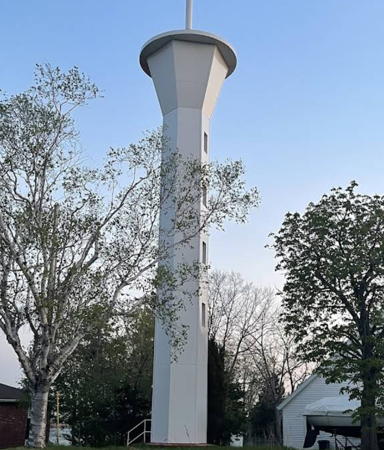
1969 (station established 1890). Active; focal plane 26.5 m (87 ft); continuous yellow light visible in a narrow arc including the range line. 18 m (60 ft) hexagonal concrete tower flaring outward at the top to support the gallery. Lighthouse is white with a red vertical stripe on the range line. A 2023 photo is at right, Trabas has Boucher's photo, Lighthouse Digest has a closeup photo, and Google has a street view and a satellite view. The original light on a skeletal tower was blown over by a gale in 1900. Anderson has a historic photo of the second light, which was destroyed by fire in 1930. This modern lighthouse is not included in the divestiture program. In April 2015 there was an uproar when a cellphone transmitter was mounted on the lighthouse. Located on Queen Elizabeth Drive north of Viceroy Avenue in Charlottetown. The tower is on private property but it can be viewed at close range from the street. Site and tower closed. Owner/site manager: Canadian Coast Guard. ARLHS CAN-127; CCG A-995; Admiralty H1012.1; NGA 8244.
*Warren Cove (Warren Farm) Range Front
1907. Active; focal plane 17 m (56 ft); continuous yellow light visible only on the range line. 7.5 m (25 ft) square pyramidal wood tower with flared gallery and square lantern. Tower painted white with red trim and a red vertical stripe on the range line; lantern painted red. Ryan Xu has a 2021 photo, Lighthouse Digest has Carol Livingstone's photo, Trabas has Boucher's closeup photo, Larry Myhre has a photo of both range lights, Marinas.com has aerial photos, and Google has a street view and a satellite view. This is an outbound range for vessels leaving Charlottetown; the lighthouse has been moved several times to accommodate changes in the channel. In 2008 the Coast Guard replaced the siding on both range lights and made other renovations that changed somewhat the historic appearance of the lighthouse. A community group has submitted a petition to assume ownership under the Parks Canada Heritage Lighthouse Program. Located on the west side of Charlottetown harbor. Site open, tower closed. Site manager: Skmaqn-Port La Joye-Fort Amherst National Historic Site. ARLHS CAN-130; CCG A-996; Admiralty H1016; NGA 8248.
*Warren Cove (Warren Farm) Range Rear
1907. Active; focal plane 23 m (76 ft); continuous yellow light visible only on the range line. 7.5 m (25 ft) square pyramidal wood tower with flared gallery and square lantern. Tower painted white with red trim and a red vertical stripe on the range line; lantern painted red. Douglas Wong has a 2022 photo, Lighthouse Digest has Carol Livingstone's photo, Trabas has Boucher's closeup photo, Dan Hentschel has a photo, Larry Myhre has a photo of both range lights, Marinas.com has aerial photos, and Google has a street view and a satellite view. In 2008 the Coast Guard replaced the siding on both range lights. A community group has submitted a petition to assume ownership under the Parks Canada Heritage Lighthouse Program. Located on the west side of Charlottetown harbor. Site open, tower closed. Site manager: Skmaqn-Port La Joye-Fort Amherst National Historic Site. ARLHS CAN-131; CCG A-997; Admiralty H1016.1; NGA 8252.
 

Brighton Beach Range Rear Light, Charlottetown, June 2023
Google Maps photo by SKS FUNG
 
* Blockhouse Point (3)
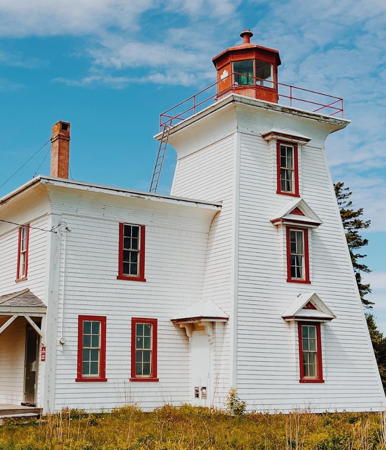
1876 (station established 1846). Active; focal plane 17 m (56 ft); white light occulting every 4 s. 12 m (40 ft) square pyramidal wood tower with lantern and gallery, attached at one corner of a 2-story wood keeper's house. Buildings painted white with red trim; lantern and gallery painted red. Kung-E Cheng's photo is at right, Trabas has Boucher's closeup photo, a 2022 photo is available, Lighthouse Digest has Michel Forand's photo, Jason Cooke has a 2017 photo, Larry Myhre has a photo, Marinas.com has aerial photos, and Google has a street view and a satellite view. This is the second oldest light station on the island. In 2012 the Friends of the Blockhouse Lighthouse was formed to work for preservation of the lighthouse, and a business plan has been submitted. However, the native Mi'kmaq Confederacy has a right of refusal for the land transfer. By 2017 the Friends were alarmed to see serious deterioration in the lighthouse; following their protests the Coast Guard moved to make critically needed repairs. James Barbu's September 2018 photo shows the resulting improvements. In April 2023 Fisheroes and Oceanss reached a deal with the Abegweit First Nation conveying to them control of the property. Located off PE 19 on the west side of Charlottetown harbor. Site open, tower closed. Site manager: Canadian Coast Guard. . ARLHS CAN-046; CCG A-993; Admiralty H1008; NGA 8236.
St. Peter's Island (4?)
1980s (station established 1866). Reactivated (inactive 1964-?). focal plane 21 m (68 ft); white flash every 4 s. 11.5 m (38 ft) square pyramidal wood tower with lantern and gallery. Lighthouse painted white, lantern roof red. Tara Caouette has a closeup 2023 photo, Marinas.com has aerial photos, and Google has a satellite view. This is a landfall light for Charlottetown for vessels approaching from the west. Nothing is known about the form of the first light. The second (1881) lighthouse was originally built at the western end of St. Peter's Island; the lighthouse was moved in 1884 to somewhere near the present location. The light was moved in 1964 to the top of an ugly metal cylinder painted with red and white horizontal bands. We need better information on this station. The light has been returned to the original tower. The foundation pad of the metal light tower remains. A community group has applied for ownership of the lighthouse. Located on the southeast side of the island, in the western entrance to Charlottetown Harbour about 2.5 km (1.5 mi) east southeast of Rice Point. Accessible only by boat. Site open, tower closed. Site manager: Canadian Coast Guard. ARLHS CAN-481; CCG A-1007; Admiralty H0996; NGA 8216.

Blockhouse Point Light, Charlottetown, August 2019
Google Maps photo by Kung-E Cheng

Victoria Lighthouses
*** Victoria Harbour (Leards Range Front/Palmer Range Rear) (2)
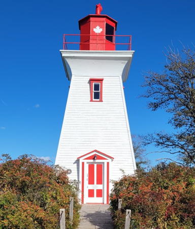
1879 (station established 1873). Inactive since 2020. 10.5 m (35 ft) square pyramidal wood tower with flared gallery and square lantern. Tower painted white with red trim; lantern painted red. The tower also carries a triangular board with a red vertical daymark on the Palmer range line. Madeleine Campeau's 2021 photo is at right, Jordan Rideout has a 2021 photo, Jimmy Emerson has a good 2010 photo, Alan Culley has an excellent 2007 photo, Trabas has Boucher's closeup photo, Marinas.com has aerial photos, and Google has a street view and a distant satellite view. This lighthouse formerly carried two range lights, the Leards Range Front Light (inactive since 2011) and the Palmer Range Rear Light (inactive since 2010). The range daymarks seen in older photos have been removed. The two range lights were replaced by a single general purpose light. Ownership of the lighthouse was transferred to the Village of Victoria in 2012. In 2019 the lighthouse received Heritage designation. The light was deactivated in February 2020. Located near the wharf at Victoria, close to Victoria Provincial Park. Site open, tower open daily July 1 through September 15 (no stairs, but visitors are allowed to climb the ladder to the lantern). Owner: Village of Victoria. Site manager: Victoria Seaport Lighthouse Museum. . ARLHS CAN-512 (=1321); ex-CCG A-1008.1, ex-Admiralty H1036 (also ex-H1028); ex-NGA 8264.
Leards Range Rear
1879. Inactive since 2011. 14 m (45 ft) square pyramidal wood tower with lantern and gallery, painted whit; lantern roof painted red. The tower formerly had a red vertical stripe on the range line, but the stripe was removed after the range was discontinued. Ryan Xu has a 2021 photo, Lucie Bellemare has a 2023 closeup, Alan Culley has a 2007 photo, and Google has a street view and a satellite view. Located east of Nelson Street about 800 m (1/2 mi) northwest of the front range light. The lighthouse is on private property, but it can be seen from Nelson Street. The Victoria Seaport Lighthouse Museum has applied for ownership of the lighthouse. Owner/site manager: Canadian Coast Guard. ARLHS CAN-513; ex-CCG A-1009; ex-Admiralty H1028.1; ex-NGA 8268.
Wrights Range Front (2)
1903 (station established 1894). Inactive since 2014. 3.5 m (12 ft) square tower, painted white with a red vertical stripe on the range line. No lantern; the light is displayed through a square opening. Lighthouse Digest has Carol Livingstone's closeup photo, and Google has a satellite view. The Victoria Seaport Lighthouse Museum has applied for ownership of the lighthouse. This tiny lighthouse is located on private property on a bluff overlooking Victoria; it is visible from the waterfront. Site and tower closed. Site manager: private. ARLHS CAN-516; ex-CCG A-1010; ex-Admiralty H1032; ex-NGA 8272.

Victoria Seaport Light, Victoria, October 2021
Instagram photo by Madeleine Campeau
Wrights Range Rear
1894. Inactive since 2014. 10 m (32 ft) square pyramidal wood tower with square lantern and gallery, painted white with a red vertical stripe on the range line. Ryan Xu has a 2021 photo, Lighthouse Digest has Carol Livingstone's photo, Marinas.com has aerial photos, and Google has a satellite view. The Victoria Seaport Lighthouse Museum has applied for ownership of the lighthouse. Located in the yard of a privately-owned cottage at the end of Beach Light Road, about 800 m (1/2 mi) west of the front range light. Site and tower closed. Site manager: private. ARLHS CAN-517; ex-CCG A-1011; ex-Admiralty H1032.1; ex-NGA 8276.

Information available on lost lighthouses:

Notable faux lighthouses:

Adjoining pages: South: Northwestern Nova Scotia | West: Western Prince Edward Island

Return to the Lighthouse Directory index

Posted December 2002. Checked and revised March 16, 2024. Lighthouses: 38. Site copyright 2024 Russ Rowlett and the University of North Carolina at Chapel Hill.