Lighthouses of Saint Vincent and the Grenadines

Saint Vincent and the Grenadines is an independent British Commonwealth Realm in the Windward Islands of the West Indies, located to the south of Saint Lucia and to the north of Grenada. Although it was originally colonized by the French, the country was a British colony from 1783 until it achieved independence in 1979. The country includes the large island of Saint Vincent and the northern two thirds of the Grenadines, a chain of small islands between Saint Vincent and Grenada. Tourism in the country has been encouraged recently by the filming of the Pirates of the Caribbean movies on St. Vincent.

Aids to navigation in St. Vincent and the Grenadines are the responsibility of the St. Vincent and the Grenadines Port Authority (SVGPA).

ARLHS numbers are from the ARLHS World List of Lights. Admiralty numbers are from volume J of the Admiralty List of Lights & Fog Signals. U.S. NGA List numbers are from Publication 110.

General Sources
Online List of Lights - St. Vincent and the Grenadines
Photos by various photographers posted by Alex Trabas. Currently the St. Vincent photos are by Rainer Arndt and Capt. Theo Hinrichs.
World of Lighthouses - St. Vincent and the Grenadines
Photos by various photographers available from Lightphotos.net.
Leuchttürme auf den Kleinen Antillen
Photos posted by Bernd Claußen.
GPSNauticalCharts
Navigation chart information for Saint Vincent.
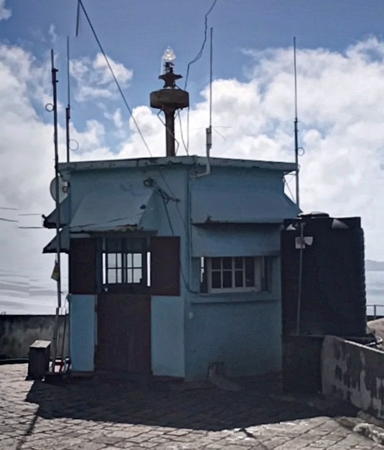

Fort Charlotte Light, Kingstown,December 2022
Google Maps street view by giggel

Saint Vincent Lighthouses
[Duvernette Island]
Date unknown. Active; focal plane 70 m (230 ft); two very quick white flashes every 2 s. 9 m (30 ft) triangular skeletal mast with lantern. Rakesh Gami has the 2018 photo at right, a distant view is available, Trabas has Capt. Theo's distant view, and Google has a closeup street view and an indistinct satellite view. Located atop a massive rock islet off the southern tip of St. Vincent. Accessible only by boat; it's a stiff climb up the rock to the lighthouse. Site status unknown. Admiralty J5816; NGA 15068.
* [Kingstown Pier]
Date unknown. Active; focal plane 12 m (39 ft); green flash every 3 s. 8 m (26 ft) mast supporting a platform; the mast carries a square green daymark. Trabas has Arndt's photo and Google has an indistinct satellite view. Located on the ferry and cruise ship pier at Kingstown, the island's capital. Accessible by walking the pier. Site open, tower closed. Admiralty J5817.51.
[Kingstown Jetty]
Date unknown. Active; focal plane 10 m (33 ft); green flash every 3 s. 8 m (26 ft) mast supporting a platform; the mast carries a square green daymark. Trabas has Arndt's photo and Google has an indistinct satellite view. Located at the end of the jetty extending from the ferry and cruise ship pier. Accessible only by boat. Site open, tower closed. Admiralty J5817.5; NGA 15093.
 
** Fort Charlotte
1892(?) (station established 1858). Active; focal plane 195 m (640 ft); three long (1.5 s) white flashes, separated by 3 s, every 20 s. Light mounted on a short mast atop a 1-story hexagonal wood watch room, the whole structure resting atop a point of the historic fort. Watch room painted blue. A 2022 street view is at the top of this page, a 2012 photo is available, Eric Hutton has a 2007 photo, David Christian has a closeup photo, Trabas has Arndt's very distant view, Marinas.com has aerial photos of the fort, and Google has a satellite view. The lighthouse has been repainted since 2004; formerly it was painted white with blue trim. The site offers an outstanding view southwestward toward the Grenadines. Fort Charlotte was built in 1806 during the Napoleonic wars. Located atop Berkshire Hill on the west side of Kingstown, St. Vincent's capital. The fort is open to guided tours; it appears from the photos that the watch room is often open to visitors. Site manager: St. Vincent and the Grenadines Port Authority. ARLHS STV-001; Admiralty J5817; NGA 15064.

Duvernette Island Light, Saint Vincent, February 2018
Google Maps photo by Rakesh Gami

Bequia Lighthouse
[West Cay (2)]
Date unknown. Active; focal plane unknown; whit flash every 10 s. Approx. 10 m (33 ft) triangular skeletal mast. A photo is available and Capt. Theo has a distant view from the sea but the light is not seen in Google's fuzzy satellite view. This light is listed by NGA and charted by C-Map with a focal plane of 13 m (43 ft), but this must refer to a former light at a lower elevation. Bequia is the largest and northernmost of the Granadines; it has a population of about 5300. Located atop a small island off the westernmost point of Bequia. Site status unknown. Admiralty J5819; NGA 15160.

Information available on lost lighthouses:

Notable faux lighthouses:

Adjoining pages: North: St. Lucia | East: Barbados | South: Grenada

Return to the Lighthouse Directory index | Ratings key

Posted December 8, 2005. Checked and revised March 17, 2025. Lighthouses: 1. Site copyright 2025 Russ Rowlett and the University of North Carolina at Chapel Hill.