Lighthouses of Venezuela: Caribbean Islands

Located on the north coast of South America, the Bolivarian Republic of Venezuela was colonized by Spain early in the 16th century and was ruled as part of the Viceroyalty of New Granada until the viceroyalty won its independence in a complex struggle in 1810-1819. The former viceroyalty, known as Gran Colombia, fell apart in 1831, creating the nations of Colombia, Venezuela, and Ecuador.

Venezuela has a long coastline facing the Caribbean Sea. In addition, Venezuela administers a number of islands in the westward extension of the Lesser Antilles chain. Geographers call these islands the Leeward Antilles, from the Dutch Benedenwindse Eilanden; the chain also includes the Dutch islands of Bonaire, Curaçao, and Aruba. This page lists the lighthouses of the Venezuelan Leeward Antilles.

Venezuela is a federal republic with 23 states and a capital district. The Isla de Margarita and associated smaller islands comprise the state of Nueva Esparta; the smaller, mostly unpopulated islands are governed as federal territories (Dependencias Federales).

The word for a lighthouse is faro in Spanish; smaller lighthouses are often called balizas (beacons). In Spanish isla is an island, cabo is a cape, punta is a promontory or point of land, péñon is a rock, arrecife is a reef, bahía is a bay, ría is an estuary or inlet, estrecho is a strait, río is a river, and puerto is a port or harbor.

Active lighthouses in Venezuela are owned by the navy and managed by the Oficina Coordinadora de Hidrografía y Navegación (OCHINA).

Special note: As of this revision in August 2026 conditions in Venezzuela are unstable and travel there is not recommended. In January 2026 U.S. forces intervened in the country and removed the dictatorial President Nicolás Maduro. On 24 June 2026 two powerful earthquakes coming in quick succession devastated a large part of the countrya and killed at least 6100 people..

ARLHS numbers are from the ARLHS World List of Lights. Admiralty numbers are from volume J of the Admiralty List of Lights & Fog Signals. U.S. NGA numbers are from Publication 110.

General Sources
Online List of Lights - Venezuela - Leeward Antilles and Isla Aves
Photos by various photographers posted by Alexander Trabas. The Venezuelan Caribbean photos are by Andreas Köhler, Capt. Theo Hinrichs ("Capt. Theo"), and Capt. Peter Mosselberger ("Capt. Peter").
Lighthouses in Venezuela
Photos by various photographers available from Wikimedia.
World of Lighthouses - Venezuela
Photos by various photographers available from Lightphotos.net.
Anexo: Faros de Venezuela
Articles and photos from the Spanish edition of Wikipedia.
World Lights - Venezuela
Historic postcard images posted by Michel Forand.
Leuchttürme Südamerikas auf historischen Postkarten
Historic postcard images posted by Klaus Huelse.'
Google Maps
Satellite view of the Isla de Margarita.


La Puntilla Light, Porlamar, December 2023
Google Maps photo by John Atehortua

Dependencias Federales Lighthouses

Los Monjes Islands Lighthouses
The Los Monjes Islands are three small islands in the mouth of the Gulf of Venezuela about 50 km (30 mi) off the Colombian coast. The islands are barren and uninhabited. Colombia claimed the islands for many years but surrendered its claim to Venezuela in 1952. The Venezuelan Navy maintains a small outpost on the largest island.

#Monjes del Sur (1)
1952. Inactive since 2003. This was an approx. 11 m (36 ft) round stone tower with gallery, painted with red and white horizontal bands. At some point the lantern was removed and the light was displayed from a short mast. The old lighthouse has apparently been demolished. ARLHS VEN-034.
Monjes del Sur (2)
2003 (station established 1952). Active; focal plane 87 m (285 ft); white flash every 10.6 s. 13 m (42 ft) round rubblestone tower with lantern and gallery, painted white with a red horizontal band, attached to a 1-story service building. This station is staffed by the Venezuelan Navy. Trabas has Capt. Peter's closeup 2018 photo (seen at right), OCHINA posted a photo, Jesus Nones has a closeup 2017 photo, Wikimedia has a distant view by Rainer Radloff, and Google has a satellite view. The light guides vessels entering the Gulf of Venezuela from the Caribbean Sea. Nones's view from the lighthouse shows how the two southernmost Monjes del Sur islets have been joined by a causeway and developed as a military outpost. Located at the summit of Los Monjes del Sur. Accessible only by boat. Site and tower closed; landing on the island requires permission of the navy. ARLHS-013; Admiralty J6270; NGA 16852.

Islas de las Aves Lighthouses
The Islas de las Aves should not be confused with Aves Island (see the bottom of this page), another Venezuelan possession, which is far away in the eastern Caribbean. The Las Aves islands are the small cays of two extensive reefs located roughly halfway between the Dutch island of Bonaire and the Islas los Roques. The islands are uninhabited but are often visited by scuba divers.

Aves de Sotavento (Leeward Aves) (3) (?)
Date unknown (station established 1931). Possibly destroyed but listed focal plane 16 m (52 ft); white flash every 7 s. Approx. 13 m (43 ft) square pyramidal steel skeletal tower with gallery, painted with red and white horizontal bands. Trabas has a 2016 view from the sea by Capt. Peter and Google has a distant satellite view, but no trace of the tower is seen in a 2023 aerial view by Albert Acevedo. Located on Isla del Faro, a small cay at the northwest end of the western reef complex. Accessible only by boat. Site open, tower closed. Admiralty J6419; NGA 17004.

2003 Los Monjes Light, Monjes del Sur, March 2018
photo copyright Capt. Peter Mosselberger; used by permission
 
Aves de Barlovento (Windward Aves)
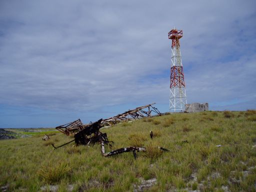
Date unknown. Active; focal plane 16 m (52 ft); one long (1.5 s) white flash every 10 s. Approx. 12 m (39 ft) square pyramidal steel skeletal tower with gallery, painted with red and white horizontal bands. Trabas has Capt. Peter's 2016 photo and Google has an indistinct satellite view. This light has probably been rebuilt several times; there's a photo of one earlier tower on the ground. Located near the western tip of a cay at the southeast end of the eastern reef complex. Accessible only by boat. Site open, tower closed. ARLHS VEN-002; Admiralty J6420; NGA 17000.

Islas de los Roques Lighthouses
The Islas de los Roques are an archipelago of more than 50 islands with a rich associated complex of coral reefs, located about 150 km (90 mi) north of La Guaira. The islands have been a national park since 1972. El Gran Roque, one of the larger islands, has a permanent population of about 3100 and an airstrip accessible by small aircraft; air transportation from Maiquetía can be arranged.

Cayo de Agua (2)
Date unknown (recent). Active; focal plane 17 m (56 ft); white flash every 15 s. 15 m (49 ft) round cylindrical fiberglass tower with lantern and gallery, painted with orange and white horizontal bands. Lina Borneo has a 2017 street view, (also seen at right), Lightphotos.net has a photo, Trabas has a 2011 photo by Capt. Hinrichs, and Google has a satellite view. Located on a small cay at the west end of the Los Roques archipelago. Accessible only by boat. Site open, tower closed. Site manager: Parque Nacional de los Roques. ARLHS VEN-006; Admiralty J6425; NGA 17012.

Cayo de Agua Light, Los Roques, August 2017
Google maps street view by Lina Borneo
* El Gran Roque (4?)
Date unknown. Active; focal plane 114 m (374 ft); white flash every 10 s. 6 m (20 ft) hexagonal fiberglass pillar, orange with a white horizontal band. Nestor Riveros has a distant 2026 view of the light at the summit of Gran Roque and Google has a distant satellite view. Located on heights at the west end of the island, about 1.5 km (0.9 mi) west of the historic lighthouse. Site open, tower closed. ARLHS VEN-009; Admiralty J6424; NGA 17008.
* El Gran Roque (Los Roques, Faro Holandés) (2)
1875. Reactivated (inactive, since the 1950s at least, until 2019); focal plane 79 m (259 ft); white flash every 6 s. Approx. 18 m (60 ft) square pyramidal stone tower recently encased in white concrete. Eduardo Peña's 2025 photo is at right, Jorge Riera has a 2019 photo, Jovito Rodriguez has a 2018 photo, and Google has an indistinct satellite view.The history of this derelict lighthouse is somewhat unclear. Apparently construction was started by the Dutch colony of Bonaire but it was completed by the Venezuelan government after it established control over the islands in the early 1870s. It recent years the lighthouse has been a picturesque ruin; José Ilidio Spinola has a good 2011 photo, Lightphotos.net has a closeup photo, Wikimedia has a 2004 closeup by Procsilas Moscas, Edwin Rivera has a 2007 closeup, and Pedro Gonzalez has a closeup 2016 street view. But in 2017 the lighthouse was surrounded by scaffolding and encased in concrete with a roof over an observation level at the top; Tomas Fernandez has a March 2017 photo of the restoration in progress. Located on a hill in the center of El Gran Roque, at the northern end of the reef complex. Site open and tower open. Site manager: Parque Nacional de los Roques. . ARLHS VEN-025; Admiralty J6424.5.
Punta Sebastopol (3)
2002 (station established 1970). Active; focal plane 12 m (39 ft); white flash every 6 s. Approx. 10 m (33 ft) round cylindrical fiberglass tower with gallery, painted with orange and white horizontal bands. Trabas has the 2014 photo by Capt. Peter and Google has a satellite view. This light marks the Boca de Sebastopol, one of the few good entrances through the reef. The original skeletal tower was replaced by a fiberglass tower in 1992; that tower was patched up after being heavily damaged by Hurricane Brett in 1993. Located on Cayo Grande at the southeastern point of the reef complex. Site open, tower closed. Site manager: Parque Nacional de los Roques. ARLHS VEN-022; Admiralty J6425.4; NGA 17016.


El Gran Roque Light, Islas los Roques, January 2025
Google Maps photo by Eduardo Peña


Isla La Orchila Lighthouse
La Orchila is a high island about 40 km (25 mi) east of the Los Roques archipelago. The island is a Venezuelan Air Force base; it includes a presidential retreat and vacation housing for military officers.

Cerro Walker
1968. Active; focal plane 137 m (449 ft); white flash every 10 s. 6 m (20 ft) square skeletal tower painted red with a white horizontal band. No photo available but Google has a distant satellite view of the station. Located on the summit of the island, near the northwestern tip. Site and tower closed. ARLHS VEN-049; Admiralty J6426; NGA 17024.

Isla Farallón Centinela Lighthouse
Isla Farallón Centinela (5?)
2001 (station established 1930). Active; focal plane 44 m (146 ft); white flash every 12 s. 6 m (20 ft) square skeletal tower painted with red and white horizontal bands. No lantern. Trabas has Capt. Theo's 2011 photo, a 2008 closeup shows the present tower, and Jairo Orrego has a view from the sea that also shows an earlier tower, but the tiny island is missing from Google's satellite view. The phrase farollón centinela means "little sentry lighthouse." NGA misspells the name as "Isla Farallin." Located atop an isolated rock in the Caribbean about 40 km (25 mi) north of Cabo Codera. Accessible only by boat; landing is difficult. Site and tower closed. ARLHS VEN-010; Admiralty J6462; NGA 17036.

Isla La Tortuga Lighthouses
Isla La Tortuga is an uninhabited island about 30 km (20 mi) north of the mainland and 140 km (90 mi) west of Isla de Margarita. Fishing camps on the island are occupied seasonally.

Cayo Herradura (3?)
2005 (station established 1939). Active; focal plane 14 m (46 ft); white flash every 10 s. 13 m (43 ft) round fiberglass tower with lantern and gallery, painted with red and white horizontal bands. Edgar Espinoza's photo is at right, Trabas has Capt. Peter's 2017 photo (also seen at right) and Google has a satellite view. The lighthouse is very similar to the Isla Chimana Segunda lighthouse (see the Eastern Venezuela page). Cayo Herradura is a cay off the north coast of Isla La Tortuga. Accessible only by boat. Site open, tower closed. ARLHS VEN-007; Admiralty J6472; NGA 17028.

Cayo Herradura Light, Isla la Tortuga, December 2017
photo copyright Capt. Peter Mosselberger; used by permission
Punta Oriental (Isla La Tortuga) (3)
Date unknown (station established 1939). Active; focal plane 17 m (56 ft); white flash every 7.5 s. 15 m (49 ft) square skeletal tower painted with red and white horizontal bands. Trabas has Capt. Peter's 2017 photo and Google has an indistinct satellite view. The previous light was a round fiberglass tower with lantern and gallery, painted with red and white horizontal bands. Located at the southeastern tip of Isla La Tortuga. Accessible only by boat. Site open, tower closed. ARLHS VEN-020; Admiralty J6474; NGA 17032.

Isla La Blanquilla Lighthouse
Isla La Blanquilla (3?)
Date unknown. Active; focal plane 27 m (89 ft); white flash every 2.5 s. 14 m (46 ft) square skeletal tower with gallery, painted with red and white horizontal bands. Trabas has a distant 2012 view by Capt. Hinrichs, and Google has an indistinct satellite view. NGA lists a round fiberglass tower. Isla La Blanquilla is a low island about 10 km (6 mi) in diameter, 120 km (75 mi) northwest of Isla Margarita. Located on the southwestern coast of the island. Accessible only by boat. Site open, tower closed. Site manager: Parque Nacional de los Roques. ARLHS VEN-023; Admiralty J6476; NGA 17014.

Islas Los Frailes Lighthouse
Isla Los Frailes
Date unknown. Active; focal plane 160 m (525 ft); white flash every 15 s. 12 m (39 ft) square skeletal tower with gallery, colored with red and white horizontal bands. Trabas has Capt. Peter's 2017 photo and Google has a distant satellite view. Isla los Frailes (Friars Island) is a high island about 16 km (10 mi) off the northeast coast of Isla Margarita. Accessible only by boat. Site status unknown. Admiralty J6508.5; NGA 17153.

Punt Oriental Light, La Tortuga, December 2017
photo copyright Capt. Peter Mosselberger; used by permission

Nueva Esparta Lighthouses

Isla de Margarita Lighthouses
Isla de Margarita is by far Venezuela's largest island, about 80 km (50 mi) long and about 40 km (25 mi) off the coast. It has a population of about 500,000 and prior to the unrest in Venezuela it had become a very popular destination for tourists from both North and South America. The island is accessible by air or by ferry from Puerto la Cruz or Cumana on the mainland.

*
La Puntilla de Porlamar
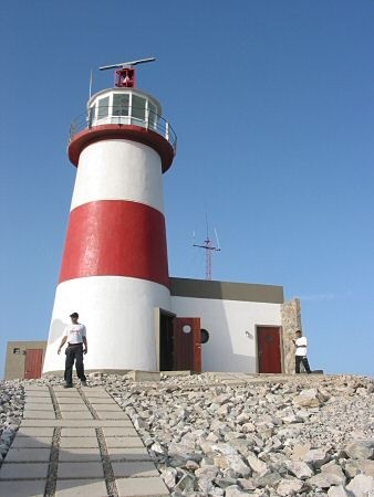
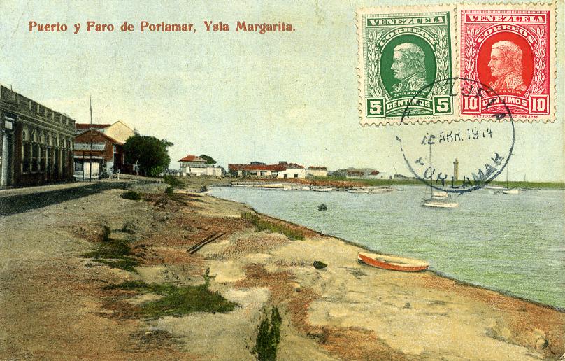
1896. Active; focal plane 20 m (66 ft); long (1.5 s) white flash every 10s. 15 m (49 ft) octagonal masonry tower with lantern and gallery, painted with pink and white horizontal bands. John Atehortua's 2023 photo is at the top of the page, Yeffersson Henriquez has a 2024 photo, Juan Salazar has a 2017 photo, Trabas has Köhler's 2012 photo, Nestor Rodriguez has a 2021 closeup, José Gutierrez has a 2016 photo, Huelse has a distant postcard view, and Google has a satellite view. The lighthouse is located east of Calle la Marina on the waterfront of Porlamar, the principal town of the Isla Margarita, on the south coast of the island. Site open, tower closed. ARLHS VEN-012; Admiralty J6503; NGA 17154.
Punta Mosquito (La Isleta)
Date unknown. Active; focal plane 30 m (98 ft); white flash every 6 s. Approx. 16 m (52 ft) round fiberglass tower with lantern and gallery, colored with orange and white horizontal bands. A 2025 photo by Yuan Picos is at right and but Google has a satellite view. Located on the southeastern point of Isla Margarita, about 12 km (7.5 mi) southwest of Porlamar. Site status unknown. ARLHS VEN-019; Admiralty J6508; NGA 17152.
* Punta La Piedra (2?)
Date unknown. Active; focal plane about 18 m (59 ft); white flash every 10 s. Approx. 15 m (49 ft) fiberglass tower with lantern and gallery, colored in red and white horizontal bands.. Francisco Marcano has a distant 2022 photo, Selmo Oliveira has a 2015 view from the sea, and Google has a satellite view. José Ilidio Spinola has a 2009 photo showing a different tower. Located on the waterfront at Punta La Piedra, the terminal for ferries bringing visitors to the island from the mainland. Site open, tower closed. Admiralty J6500.7.
Punta Manglillo (2?)
Date unknown. Active; focal plane unknown; white flash every 10 s. 12 m (39 ft) round fiberglass tower colored with red and white horizontal bands. Trabas has Rainer Arndt's distant 2012 view and Google has an indistinct satellite view. NGA lists the focal plane as 12 m (39 ft); this is either an error or the light has been moved uphill a considerable distance. Located on a high bluff near the southwestern corner of the island. Site status unknown. Admiralty J6500.6; NGA 17162.5.
* [Muelle de Robledal]
Date unknown. Active; focal plane 6 m (20 ft); white flash every 5 s. 3 m (10 ft) hexagonal fiberglass tower colored red with a white horizontal band. Jose Ortiz Guzman has a photo and Google has a distant satellite view. Located on the pier at Robedal, a town at the west end of the island. Site open, tower closed. Admiralty J6500.1; NGA 17163.
Morro de Robledal
Date unknown. Reactivated (inactive 2016-18); focal plane 80 m (262 ft); white flash every 8 s. 10 m (33 ft) octagonal fiberglass tower, colored with red and white horizontal bands. No photo available but Google has an indistinct satellite view. Located on a high promontory at the west end of the island. Site open, tower closed. ARLHS VEN-014; Admiralty J6500; NGA 17164.

Punta Mosquito Light, Porlamar, July 2025
Google Maps photo by Yuan Picos
Punta Tigre
Date unknown. Active; focal plane 12 m (39 ft); one long (1.2 s) white flash every 12 s. Approx. 8 m (26 ft) square skeletal tower painted with red and white horizontal bands. Trabas has Capt. Peter's 2017 photo but this lighthouse has not been located; it is not seen at the listed location, which seems too far inland. Located on a promontory on the northwest side of the island. Site status unknown. Admiralty J6499; NGA 17162.3.
* La Guardia (Ensenada La Guardia, Punta La Sabila)
Date unknown. Active; focal plane 12 m (39 ft); two white flashes every 12 s. Approx. 10 m (33 ft) hexagonal fiberglass tower, painted with red and white horizontal bands. Trabas has Köhler's 2012 photo, Javier Delgado has a closeup photo, Alvaro Fuentes Vasquez has a 2017 photo and Google has a satellite view. Located on a sharp point of land about 7 km (4.5 mi) north of La Guardia on the north coast of Isla Margarita. Site open, tower closed. Admiralty J6500.8; NGA 17162.1.
* Punta Faragoza (Punta Zaragoza)
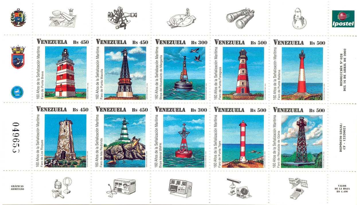
1997. Active; focal plane 85 m (279 ft); white flash every 10 s. 23 m (75 ft) hexagonal tower with lantern and gallery, painted with red and white horizontal bands. Yuri Koltsov's 2023 photo is at right, Vladimir Dorokhov has a 2021 photo, Trabas has Köhler's 2012 photo, José Ilidio Spinola has a photo, Luis Albert Molina has a 2019 photo, a 2002 postage stamp shows the lighthouse, and Google has a good satellite view. The lighthouse was formerly described in NGA as being "rubblework," indicating that the present tower replaced an older stone tower. Located on a promontory about 10 km (6 mi) southwest of the northeastern tip of Isla Margarita. Accessible by hiking trail from a popular beach on the east side of the promontory. Site open, tower closed. . ARLHS VEN-017; Admiralty J6501; NGA 17162.
Cabo Negro (Cabo de la Isla) (3)
Date unknown (station established 1929). Active; focal plane 70 m (230 ft); white flash every 5 s. 12 m (39 ft) hexagonal tapered fiberglass tower with lantern and gallery, painted red with a white horizontal band. Trabas has a Capt. Theo's distant 2009 view and Google has a distant satellite view. Located on the northeastern tip of Isla Margarita. Site status unknown. ARLHS VEN-004; Admiralty J6502; NGA 17160.
* El Tirano (Puerto Fermin) (2)
2018. Active; focal plane 15 m (49 ft); white flash every 6 s. 12 m (39 ft) round tower colored with red and white horizontal bands. Javier Calzavara has a 2023 photo and Google has a satellite view. This lighthouse replaced a 12 m (39 ft) square skeletal tower painted with red and white horizontal bands, located on the short breakwater of Puerto Fermin; Claudio Ceppi has a 2016 photo and Nicolas Lavalle has a distant 2017 view. Located on the beach north of the breakwater at Puerto Fermin. Site open, tower closed. Admiralty J6502.1; NGA 17161.

Punta Faragoza Light, Isla Margarita,February 2023
Google Maps photo by Yuri Koltsov
** Punta Ballena (Pampatar) (2)
2007 (station established 1999). Active; focal plane 76 m (249 ft); white flash every 10 s. 30 m (98 ft) tapered octagonal concrete tower with lantern and gallery, rising from a semicircular 1-story building. The tower is colored with dull orange and white vertical stripes. Andres Ramos has the 2021 photo at right, Vicente Guarache has a closeup 2008 photo, Trabas has Köhler's closeup 2012 photo, Fran Paredes has a good aerial photo, Juan Lunar has a street view, and Google has a satellite view. J.D. Volcan has a June 2007 photo of the lighthouse under construction and it was announced as operational in a September 4 notice to mariners. A skeletal tower close to the lighthouse probably carried the original light. Located high on a promontory at the easternmost point of the Isla Margarita near Pampatar. Site open; it appears that the tower is open for climbing, but more information is needed on this. . ARLHS VEN-040; Admiralty J6502.25; NGA 17155.5.
* Hilton Marina Landfall
Date unknown. Active; focal plane about 16 m (52 ft); white light, pattern unknown. Approx. 14 m (46 ft) round fiberglass tower with lantern and gallery, painted with orange and white horizontal bands. Gerswin Pineda has a 2007 closeup, Carlos Gabriel Alfonzo Gaskin has a 2012 photo of the lighthouse at night, Marinas.com has aerial photos (misidentified as Faro de la Puntilla), and Google has a satellite view. Located on the beach adjacent to the Hilton Marina. Site open, tower closed. Admiralty J6502.48.
* Hilton Marina Entrance
Date unknown. Active; focal plane about 13 m (43 ft); green flash every 3 s. 10 m (33 ft) hexagonal fiberglass tower, painted green with one white horizontal band. Yesenia Boica has a 2017 photo, Trabas has Köhler's 2012 photo, Rodolfo Sanchez has a closeup, and Google has a satellite view. Located on the west mole of the Hilton Marina west of Pampatar. Accessible by walking the pier. Site open, tower closed. Admiralty J6502.45.
Morro Valdez
Date unknown. Active; focal plane unknown; white light, pattern unknown. Approx. 16 m (52 ft) square skeletal tower painted with red and white horizontal bands. Guillermo Suarez has a distant 2023 street view and Google has a satellite view. Located atop a steep hill at El Morro. Site status unknown. Admiralty J6502.405.

Punta Ballena Light, Pampatar, December 2021
Google Maps photo
by Andres Ramos

Isla de Cubagua Lighthouses
Cubagua is an island about 9 km (5.5 mi) long located south of Isla Margarita. Though it is uninhabited, the island is a popular destination for scuba divers, and day trips are available from Punta La Piedra on Margarita.

Punta Palanquete (Punta Brasil) (2)
2004. Active; focal plane 15 m (49 ft); white flash every 8 s. 12 m (39 ft) round cylindrical fiberglass tower, painted with orange and white horizontal bands. The lighthouse replaced a 10 m (33 ft) concrete post light. Francisco Salazar has the 2023 photo at right, a view from the sea is available and Google has a satellite view. Located at the northwestern point of the Isla Cubagua, about 18 km (11 mi) southwest of Punta de Piedras on the Isla de Margarita. Accessible only by boat, but there is an excellent view from ferries between Cumana and Isla Margarita. Site open, tower closed. Admiralty J6492; NGA 17168.
Punta Charagato (2)
Around 2023. Active; focal plane 15 m (49 ft); white flash every 12 s. 10 m (33 ft) round fiberglass tower painted with red and white horizontal bands. Juber Alexander Zárate Cuervo has a 2018 photo and Google has a satellite view. The earlier lighthouse was similar but had a lanrern and gallery. Wikimedia has a 2014 photo and Jesus Carrillo had a 2021 photo (no longer online) of that tower lying on the ground. Located at the northeastern point of the Isla Cubagua, about 15 km (9 mi) south southwest of Punta de Piedras. Accessible only by boat. Site open, tower closed. ARLHS VEN-035; Admiralty J6494; NGA 17172.

Isla de Coche Lighthouse
Coche is an island about 11 km (7 mi) long located southeast of Isla Margarita and east of Isla de Cubagua. The island has a permanent population of about 8200.

#Isla de Coche Harbor
2009 (?). Inactive since 2014. This was a 12 m (39 ft) fiberglass tower, colored orange with a white vertical stripe. No photo available and the tower was never located in Google's satellite view. This light appeared in the 2009 NGA List, continued to be listed through the 2014 List, and is missing from the 2015 List. Apparently located on the waterfront of the island's principal settlement, on the west coast of the island. ex-Admiralty J6492.1; ex-NGA 17175.
Isla Coche
Date unknown. Active; focal plane unknown; white light, pattern unknown. Approx. 15 m (49 ft) round fiberglass tower with lantern, colored with red and white horizontal bands. Filippo Bilotti has a 2018 photo, Alex Passini has a 2017 photo and a street view, Diego Dominguez has a more distant 2023 view, and Google has a satellite view. Located on a hillside behind San Pedro de Coche, the island's principal settlement and port. Site open, tower closed. Admiralty J6491.

Punta Brasil Light, Isla Cubagua, January 2023
ex-Google Maps photo
by Francisco Salazar

Isla de Aves Lighthouses

Isla de Aves (Bird Island) is a small, isolated scrap of land in the eastern Caribbean about 225 km (140 mi) west of Dominica and 550 km (340 mi) north of Venezuela. Having no supply of fresh water other than rainfall, the island has never been inhabited. From 1878 to 1912 it was occupied intermittantly by a U.S. company under the U.S. Guano Islands Act. Venezuela asserted its claim to the island in 1895 (based on an 1865 arbitration agreement with the Netherlands), but it took no action on the claim until 1950 when a Venezuelan naval force took physical possession of the island. In 1978 a permanent scientific station was established, staffed by scientists and protected by naval personnel.

Venezuelan ownership was confirmed in treaties with the U.S. in 1978, with France in 1980, and with Dominica, the closest nation of the Lesser Antilles, in 2006. However, erosion has claimed much of the island in recent decades and there is a danger that rising sea levels will cause it to disappear completely.

Isla Aves (2)
2002 (station established 1981). Active; focal plane 19 m (62 ft); white flash every 5 s. Light mounted atop a 3-story scientific station building, which stands on a platform supported by concrete piles. The current structure was built by a 2002 expedition and is occupied by rotating naval crews and visiting scientists. Panter Khan's 2019 photo is at right, Roman Bruehwiler has a 2013 photo, Trabas has Capt. Peter's 2017 photo, and Google has a satellite view. Accessible only by boat; Venezuelan Navy permits are required to land on the island or visit the station. Site and tower closed. ARLHS AVE-001; Admiralty J5700; NGA 16851.

Base Científico Naval Simón Bolívar, Isla Aves, May 2019
Google Maps photo by Panter Khan

Information available on lost lighthouses:

Notable faux lighthouses:

Adjoining pages: Southeast: Eastern Venezuela | Southwest: Western Venezuela | West: Bonaire

Return to the Lighthouse Directory index

Posted July 7, 2003. Checked and revised August 11, 2026. Lighthouses: 33. Site copyright 2026 Russ Rowlett and the University of North Carolina at Chapel Hill.