Lighthouses of Mexico: Northwest Coast

This page lists of lighthouses of the west coast of mainland Mexico in the states of Jalisco, Nayarit, Sinaloa, and Sonora. Lighthouses of Baja California are on separate pages, and lighthouses south of Jalisco are listed on the South Coast page. This coast faces mostly on the Sea of Cortés (Gulf of California). From Mazatlán southward the coast is open to the Pacific Ocean.

There are very few tall lighthouses along this coast. Tall towers aren't needed because in most places the coastline is high, and navigational lights can be mounted high on the bluffs and headlands.

Tourism is a major industry on much of this coast, but only a few of the lighthouses are tourist attractions. As a result, photos and visitor information are rather scarce on the Internet. If you have information on any of the lighthouses of Mexico, or photos you would be willing to share, please let me know.

Mexico is a federal republic comprised of 31 states, and the lighthouses are listed below by state. Mexican lighthouses are managed by the merchant marine directorate (Dirección General de Marina Mercante) within the Secretaría de Comunicaciones y Transportes, the cabinet agency that also manages the country's airports and seaports. Many of the larger light stations are staffed by resident civilian keepers.

ARLHS numbers are from the ARLHS World List of Lights. CF numbers are from the Mexican Cuaderno de Faros (Handbook of Lighthouses). Admiralty numbers are from volume G of the Admiralty List of Lights & Fog Signals. U.S. NGA numbers are from Publication 111.

General sources
Online List of Lights - Mexico Pacific
Photos by various photographers posted by Alexander Trabas. The photos for this region are by Capt. Peter Mosselberger ("Capt. Peter"), Douglas Cameron and Hendrik Martin Porath.
Lighthouses in Mexico
Photos by various photographers available from Wikimedia.
World of Lighthouses - Mexico
Photos by various photographers available from Lightphotos.net.
Leuchttürme Mittelamerikas auf historischen Postkarten
Historic postcard images posted by Klaus Huelse.
Cuaderno de Faros
The Mexican light list can be downloaded in two volumes, Atlantic and Pacific.

Faro de Cabo Corrientes
Cabo Corrientes Light, Jalisco, November 2005
Wikipedia Creative Commons photo by Intersofia

Jalisco Lighthouses

Lago de Chapala Lighthouses
Note: The Lago de Chapala, Mexico's largest freshwater lake, is located on the southern border of Jalisco. The lake is 80 km (50 mi) long and as much as 18 km (11 mi) wide; its normal surface elevation is listed as 1524 m (5000 ft).
*Muelle de Chapala (2)
1950s (station established 1907). Active; green light, 1 s on, 1 s off. 6 m (20 ft) concrete post projecting through the end of a pier; at pier level the tower is surrounded by a round pavilion supported by six posts. Steven Miller has a good 2007 photo, a 2008 photo is available, and Google has a street view and a satellite view. This is Mexico's best known inland lighthouse. The lighthouse was restored in 2007. Located at the end of a long pier projecting into the lake at Chapala, a town on the north side of the lake about 40 km (25 mi) south of Guadalajara. Site open; the lighthouse is accessible by walking the pier. CF-14-100; ARLHS MEX-188.
* Roca Azul
Date unknown. Active; two white flashes every 10 s. 10 m (33 ft) round brick tower with gallery; the light is atop a sombrero-style roof over an open lantern. A photo is at right, the yacht club has a good photo and a closeup photo, and Google has a satellite view. Located in a yacht club at the west end of the lake about 2.5 km (1.5 mi) south of Jocotepec. Site open; the tower is closed in the photos but may be open sometimes. Owner/site manager: Club de Yates de Chapala. CF-14-105.1.
*San Cristóbal
Date unknown. Active (unofficial); white light, characteristic unknown. Approx. 9 m (30 ft) round tower with lantern and gallery, painted yellow; lantern dome painted gray. No photo available, but Google has a satellite view. Located on the south shore of the lake about 7 km (4 mi) east of San Pedro Tesistán. Site open, tower closed.

Roca Azul Light, Jocotepec, July 2009
Panoramio Creative Commons photo by Aislander

Pacific Coast Lighthouses
Punta Graham
Date unknown. Active; focal plane 200 m (656 ft); three white flashes every 12 s. 11 m (36 ft) square skeletal tower centered on a square 1-story concrete equipment building. Trabas has Capt. Peter's photo, and Google has an indistinct satellite view. Located on a precipitous headland about 4 km (2.5 mi) south of Barra de Navidad, at the extreme southern tip of Jalisco state. Site status unknown. CF-06-005(=14-840); Admiralty G3481; NGA 15092.
Punta Farallón
Date unknown. Active; focal plane 62 m (203 ft); two white flashes every 10 s. 22 m (72 ft) round cylindrical white concrete tower with lantern, gallery, and four ribs. Entire lighthouse is white, except the lantern roof is painted red. Two 1-story keeper's houses. Trabas has Capt. Peter's photo, an excellent aerial photo is available (a little over halfway down the page), and Google has a satellite view. Near the lighthouse, at the point of the cape, is a remarkable structure, the Copa del Sol (Cup of the Sun), built by landowner and developer Gian Franco Brignone. Punta Farallón is in southern Jalisco about 135 km (85 mi) southeast of Cabo Corrientes. Site status unknown. ARLHS MEX-124; CF-14-090; Admiralty G3481.4; NGA 15088.
Cabo Corrientes
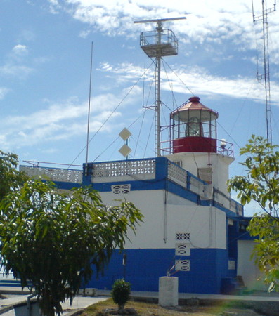
1903. Active; focal plane 93 m (305 ft); white flash every 6 s. Approx. 18 m (60 ft) octagonal cylindrical masonry tower with lantern and gallery, rising from 1-story keeper's house. Buildings painted white; lantern painted red. A photo is at the top of this page, Mario Alberto Morales Catalán has a closeup photo, Alfredo E. Lara has a photo, a 2008 view is available, and Google has a satellite view. Matt Faust visited the lighthouse in 2012 and reported the building to be in need of restoration. He found no keeper, although the station is normally staffed. The cape, about 65 km (40 mi) west of Puerto Vallarta, is one of the most important headlands of Mexico's Pacific coast. Accessible by hiking from Corrales. Site open, tower closed. ARLHS MEX-022; CF-14-065; Admiralty G3482; NGA 15080.

Puerto Vallarta Lighthouses
Note: Puerto Vallerta is a beach resort city with a metropolitan population of nearly 400,000. The marina lighthouse in Puerto Vallarta is well known and often photographed, but it is not an official aid to navigation.
* Puerto Vallarta Anterior (Range Front) (1)
1932. Inactive since 1970. 10 m (33 ft) square pyramidal tower with gallery painted with black and white horizontal bands. Aaron Anderer's closeup photo is at right, Javier Doren has a 2008 photo, another photo is available, and Google has a street view and a satellite view. The tower was repainted in 2010 with red and white bands; an October 2010 photo shows this pattern. By 2015 the bands were again black and white. The lights were deactivated when the harbor was rebuilt and the approach range shifted to the north. Located at the south end of the Malecón of downtown Puerto Vallarta, at the foot of Gaieana street, about 4 km (2.5 mi) south of the cruise ship harbor. Site open; tower closed, but visitors can climb to the gallery by an external ladder. ARLHS MEX-186.
* Puerto Vallarta Posterior (Range Rear) (1)
1932. Inactive since 1970. 12 m (39 ft) square pyramidal tower with gallery, painted with black and white horizontal bands. Lantern removed. Joost Keesing has contributed a photo, a 2008 photo is available, and Google has a street view and a satellite view. Located on Calle Matamoros just north of Calle Mina, four blocks southeast of the front light. Site open; tower closed, but visitors can climb to the gallery by an external ladder. ARLHS MEX-187.
* [Puerto Vallarta (Aramara) (Directional Light)]
2014. Active; focal plane 35 m (115 ft); white, red or green light depending on direction, 2 s on, 2 s off. 32 m (105 ft) steel mast painted with red and white horizontal bands. Google has a street view and a satellite view. Trabas has Cameron's photo of the former range front light at this location. Located beside the coastal highway at the cruise ship terminal of Puerto Vallarta. Site open, tower closed. Admiralty G3484; NGA 15064.
Puerto Vallarta Posterior
Puerto Vallarta Range Front Light, December 2009
Flickr Creative Commons photo by Aaron Anderer

Nayarit Lighthouses

Isla Marieta
Date unknown. Active; focal plane 23 m (75 ft); two white flashes every 10 s. 11 m (36 ft) square pyramidal skeletal tower, painted red; two sides of the tower carry a slatted daymark. Google has a sea view, and the shadow of the tower is seen in Google's satellite view. Located at the north end of Isla Marieta la Larga, the larger of two small islands about 40 km (25 mi) west of Puerto Vallarta. Accessible only by boat. Site open, tower closed. CF-18-145.1; Admiralty G3491; NGA 15060.
* Punta Mita (2)
Date unknown. Active; focal plane 21 m (69 ft); three white flashes every 12 s. 16 m (52 ft) triangular cylindrical concrete tower. No photo available, but Google has a satellite view. This light replaced a shorter skeletal tower. Punta Mita is a sharp cape at the northern entrance to the Bahía de Banderas; it is now the location of an upscale resort. Located in a traffic roundabout on the cape. Site open, tower closed. CF-18-100; Admiralty G3492; NGA 15056.
* San Blas Range Rear
Date unknown. Active; focal plane 19 m (62 ft); white light, 1 s on, 1 s off. 16 m (52 ft) square pyramidal skeletal tower, painted with red and white horizontal bands. Google has a street view and a satellite view. The front light is on a similar, shorter tower. Located on a street corner next to the port office, one block from the waterfront in downtown San Blas. Site open, tower closed. CF-18-030.1; Admiralty G3494.41; NGA 15015.
* San Blas (Isla del Rey)
Date unknown. Active; focal plane 44 m (144 ft); two white flashes every 10 s. 14 m (46 ft) round cylindrical concrete tower with gallery but no lantern, painted with red and white bands. The adjacent concrete keeper's house is in ruins. Emily Hoyer's photo is at right, a 2008 photo is available, Omar Silis has a 2018 closeup, and Google has a satellite view. San Blas is the principal port of Nayarit. The lighthouse is located on a peninsula (not actually an island) on the west side of the harbor entrance; boat rides are available from the town waterfront. Site open, tower closed. ARLHS MEX-095; CF-18-015; Admiralty G3494; NGA 15012.
Isla Isabela
Date unknown. Active; focal plane 55 m (180 ft); four white flashes every 16 s. 11 m (36 ft) square pyramidal skeletal tower covered with a daymark showing a red and white checkered pattern, mounted on a square concrete base. No photo available, and the light is not seen in Bing's satellite view. Isla Isabela is a small volcanic island about 30 km (19 mi) offshore and 80 km (50 mi) northwest of San Blas. The island is a national park protected for its bird nesting areas. Located above the landing area at the south end of the island. Site status unknown. CF-18-085; Admiralty G3502; NGA 15008.
Isla María Madre (Puerto Balleto)
Date unknown. Active; focal plane 62 m (200 ft); two white flashes every 10 s. 7 m (23 ft) round cylindrical concrete tower with gallery attached to a large 1-story keeper's house. Tower painted white; gallery painted with red and white vertical stripes. No photo available, but Google has a satellite view. Isla Madre is the largest of the Islas Marías, an archipelago of three large and several small islands in the entrance to the Sea of Cortés. The island is the site of a Mexican federal prison. Located on a ridge above Puerto Balleto, the only port on the island. Site status unknown. CF-18-125; Admiralty G3498; NGA 15028.
Faro de San Blas
San Blas Light, San Blas, January 2008
Flickr Creative Commons photo by Emily Hoyer

Sinaloa Lighthouses

Teacapán Lighthouse
Teacapán
Date unknown. Active; focal plane 16 m (52 ft); white flash every 6 s. 17 m (56 ft) skeletal tower, painted white. Google has a street view and a satellite view. Located on the north side of the inlet at the southern border of Sinaloa. Site open, tower closed. CF-25-380; Admiralty G3502.5; NGA 15006.

Mazatlán Area Lighthouses
* Mazatlan Fishing Harbor Range Front
Date unknown. Active; focal plane 17 m (56 ft); white flash every 3 s. 14 m (46 ft) square pyramidal skeletal tower with gallery, painted with red and white horizontal bands. Google has a street view and an aerial view. This range guides vessels into the fishing harbor on the northeast side of Mazatlán. Located on the waterfront of the harbor. Site open, tower closed. CF-25-255.
* Mazatlan Fishing Harbor Range Rear
Date unknown. Active; focal plane 22 m (62 ft); white flash every 3 s. 18 m (59 ft) square pyramidal skeletal tower with gallery, painted with red and white horizontal bands. No photo available, but Google has an aerial view. Located atop a 1-story administration building at the entrance to the harbor. Site open, tower closed. CF-25-255.1.
* Mazatlan Harbor Channel Range Front
Date unknown. Active; focal plane 19 m (62 ft); white flash every 3 s. 16 m (52 ft) square pyramidal skeletal tower with gallery, painted orange. Trabas has Cameron's photo, and Google has a street view and a satellite view. This is the harbor entrance range for Mazatlán. Located on the waterfront at the north end of the harbor. Site open, tower closed. CF-25-245; Admiralty G3504.4; NGA 14992.
* Mazatlan Harbor Channel Range Rear
Date unknown. Active; focal plane 26 m (85 ft); white light, 1 s on, 1 s off. 24 m (79 ft) square pyramidal skeletal tower with gallery, painted orange. Google has a street view and a satellite view. Located 500 m (0.3 mi) north northeast of the front light, in the middle of Altata Street (cars can actually be driven through the base of the tower). Site open, tower closed. CF-25-245.1; Admiralty G3504.41; NGA 14996.
* Mazatlan Entrance Channel Range Front
Date unknown. Active; focal plane 21 m (69 ft); white flash every 3 s. 20 m (66 ft) square pyramidal skeletal tower with gallery, painted orange. Google has a street view and a satellite view. Located on the waterfront at the northwest corner of the harbor. Site open, tower closed. CF-25-250; Admiralty G3505; NGA 14997.
* Mazatlan Entrance Channel Range Rear
Date unknown. Active; focal plane 55 m (180 ft); white light, 1 s on, 1 s off. 16 m (52 ft) square pyramidal skeletal tower with gallery, painted orange. No photo available, but Google has a satellite view. Located on heights above the city, in the Loma Atravesada neighborhood, 1.45 km (0.9 mi) north northeast of the front light. Site open, tower closed. CF-25-250.1; Admiralty G3505.1; NGA 14997.1.
Mazatlán West (Crestón) Breakwater (2)
Date unknown. Active; focal plane 21 m (69 ft); green flash every 5 s. 16 m (52 ft) square pyramidal skeletal tower. The top of the tower has a slatted white daymark in three horizontal bands. Trabas has Cameron's photo, Gregory Melle has another photo, and Google has a satellite view. The original light was on a 9 m (30 ft) concrete post. Located at the end of the breakwater, which extends eastward from the base of Isla Creston. Site and tower closed, but there's a good view from vessels entering or leaving the harbor. CF-25-235; Admiralty G3507; NGA 14976.
*** Isla Crestón (Mazatlán)
1879. Active; focal plane 157 m (515 ft); white flash every 7 s. 11 m (36 ft) square masonry tower with lantern and gallery, mounted on a 1-story service building; 2nd order Fresnel lens in use. Building painted with blue and white horizontal bands; lantern painted red. This is a staffed light station. In addition to Armando Lizarraga's photo at right, another closeup is available, Wikimedia has several photos, Trabas has Cameron's view from below, Huelse has a historic postcard view, and Google has a satellite view and Pollo Sato's street view. This is one of the best known lighthouses of Mexico, famous for its spectacular setting, high atop a gigantic rock often compared to the Rock of Gibraltar. The view is extraordinary. Navigational lights were displayed from this height as early as 1571. In Mazatlán the lighthouse is often said to be the second highest (or even highest) in the world, claims that unfortunately do not hold true even for Middle America (the lighthouses at Lovers Leap in Jamaica, Chacachacare in Trinidad, and Cap Moule-à-Chique in St. Lucia are all much higher). Located south of downtown Mazatlán at the summit of the rock, which is connected to the mainland by a causeway. Accessible by a climb (about 45 minutes each way) from the end of Paseo Centenario. Site and tower open. ARLHS MEX-027; CF-25-225; Admiralty G3504; NGA 14964.
Punta Piaxtla
Date unknown. Active; focal plane 30 m (98 ft); white flash every 5 s. 11 m (36 ft) round cylindrical concrete tower with lantern and gallery, painted with red and white horizontal bands. A 2008 closeup and a distant view are available, and Google has a satellite view. Located on a rocky headland about 50 km (30 mi) north of Mazatlán. Site status unknown. ARLHS MEX-126; CF-25-215; Admiralty G3512; NGA 14960.
Isla Crestón Light
Isla Crestón Light, Mazatlán, January 2007
Flickr Creative Commons photo by Armando Lizarraga

Culiacán and Altata Area Lighthouse
Río San Lorenzo
Date unknown. Active; focal plane 18 m (59 ft); four white flashes every 16 s. 16 m (52 ft) square skeletal tower with gallery, painted white. No photo available, but Google has a satellite view. Located on the beach about 8 km (5 mi) southwest of El Dorado. Accessible by 4WD. Site open, and nothing prevents visitors from climbing the ladder on the tower. CF-25-200; Admiralty G3513.2; NGA 14953.
Punta La Tonina (Bahía de Altata)
Date unknown. Active; focal plane 15 m (49 ft); two white flashes every 10 s. 15 m (49 ft) square skeletal tower, painted white. No photo available, but Google has a satellite view. Located on the east side of the entrance to the Altata lagoon, opposite the mouth of the Río Culiacán. Site open, tower closed. CF-25-175; Admiralty G3513.25; NGA 14952.2.
* Altata
Date unknown. Active; focal plane 18 m (59 ft); white flash every 6 s. 16 m (52 ft) square skeletal tower. The tower is in the left background of a photo by Javier Antonio Ocampo Gomez, but the tower is hard to see in Google's satellite view. Located one block off the waterfront of Altata, a town on the north side of the Bahía de Altata. Site open, tower closed. CF-25-170; Admiralty G3513.5; NGA 14944.
Punta Riscion
Date unknown. Active; focal plane 14 m (46 ft); white flash every 6 s. 15 m (49 ft) square skeletal tower, painted white. No photo available, but Google has a satellite view. Located at the north end of the Isla Altamura, marking the inlet to La Reforma. Accessible only by boat. Site status unknown (the barrier island is privately owned). CF-25-150; Admiralty G3514.4; NGA 14932.

Topolobampo Area Lighthouses
Boca de Macapule
Date unknown. Active; focal plane 17 m (56 ft); three white flashes every 12 s. 12 m (39 ft) square pyramidal white concrete tower. No photo available, but Bing has a satellite view. Located on the east side of the entrance to the Macapule lagoon, which leads to the port of Ahome. Accessible only by boat. Site open, tower closed. CF-25-135; Admiralty G3516; NGA 14924.
Cerro Partido
Date unknown. Active; focal plane 95 m (312 ft); white flash every 7 s. 5 m (17 ft) round cylindrical concrete tower with lantern and gallery. Entire lighthouse is white. A photo is at right, Jorge Lopez Rodriguez has a view from the lagoon below the light, and Google has a satellite view. Located atop a vertical cliff about 15 km (9 mi) southwest of Topolobampo. Site status unknown. CF-25-015; G3518; NGA 14920.
Punta Copas Range Rear
Date unknown. Active; focal plane 16 m (52 ft); white light, 1 s on, 1 s off. 14 m (46 ft) square skeletal tower, painted white. Luis Espero has a very distant view, and Google has a satellite view. This range guides vessels departing Topolobampo. The front light is on a shorter tower 420 m (1375 ft) northeast. Located on the point on the east side of the entrance to the Bahía de Ohuira and Topolobampo. Site status unknown. CF-25-120.1; Admiralty G3518.51; NGA 14916.
Las Animas Range Front
Date unknown. Active; focal plane 30 m (98 ft); white flash every 3 s. 12 m (39 ft) square skeletal tower, painted white. Below the tower, a strip of the hillside about 80 m (260 ft) long is paved in white concrete as a daymark. Google has a street view and a satellite view. This is the entrance range for Topolobampo, an important port of northern Sinaloa and the mainland terminal for ferries crossing the Sea of Cortés to La Paz in southern Baja California. Located on a ridge across the lagoon behind the beach town of Las Animas, about 7 km (4.5 mi) west of Topolobampo. Site status unknown, but easy to see from ferries arriving in Topolobampo. CF-25-110; Admiralty G3518.2; NGA 14909.
Las Animas Range Rear (Cerro Iturbe)
Date unknown. Active; focal plane 100 m (328 ft); white light, 1 s on, 1 s off. 8 m (26 ft) square skeletal tower, painted white. Behind the tower, a strip of the mountainside about 80 m (260 ft) long is paved in white concrete as a daymark. No photo available, but Bing has a satellite view. Located on a high ridge on the west side of Topolobampo, about 4.3 km (2.7 mi) northeast of the front light. Site status unknown. CF-25-110.1; Admiralty G3518.21; NGA 14910.
Faro de Cerro Partido
Cerro Partido Light, Topolobampo, September 2011
Panoramio photo copyright festiva88; permission requested
Farallón de San Ignacio
Date unknown. Active; focal plane 120 m (394 ft); two white flashes every 10 s. 12 m (39 ft) square skeletal tower, painted white. The Farallón de San Ignacio is massive rock emerging from the Pacific about 25 km (15 mi) southwest of Punta Copas and 16 km (10 mi) south of Punta San Ignacio. No photo available, but Bing has a satellite view. Located at the highest point of the rock. Practically inaccessible. ARLHS MEX-016; CF-25-010; Admiralty G3519; NGA 14904.

Sonora Lighthouses

Ciudad Obregón Area Lighthouses
* Yavaros (Bahía de Yavaros)
Date unknown. Active; focal plane 34 m (112 ft); white flash every 6 s. 12 m (39 ft) round concrete tower with gallery, painted with red and white horizontal bands. A distant photo shows the lighthouse in silhouette against the sunset, and Google has a street view and a satellite view. Yavaros is a small port in southern Sonora, about 12 km (7.5 mi) south of Huatabampo. Located on a sandy ridge on the west side of the entrance to the Bahía de Yavaros. Site open, tower closed. CF-26-240; Admiralty G3520; NGA 14896.
Isla Lobos
Date unknown. Active; focal plane 25 m (82 ft); white flash every 6 s. 22 m (72 ft) square pyramidal skeletal tower, painted white. No photo available, but Google has a satellite view. Located on Isla Lobos, a boomerang-shaped barrier island about 80 km (50 mi) southeast of Guaymas. Accessible only by boat. Site open, tower closed. CF-26-210; Admiralty G3526; NGA 14868.

Guaymas Area Lighthouses
Note: Guaymas is the principal port of Sonora and the mainland terminal for ferries crossing the Sea of Cortés (Gulf of California) to Santa Rosalia in Baja California.
Isla Pajaros (Guaymas)
Date unknown (station established 1913). Active; focal plane 25 m (82 ft); red flash every 5 s. 10 m (33 ft) hexagonal white concrete tower with gallery. A photo is at right, Trabas has Capt. Peter's photo, Luis Alejandro Peralta Rodriguez has a 2017 closeup, and Google has a satellite view. Isla Pajaros is a fishhook-shaped island lying across the entrance to the harbor of Guaymas. Huelse has a historic postcard view of an earlier Guaymas lighthouse. Located on the southwestern tip of the island, marking the entrance to the harbor. Accessible only by boat, but easy to see from ferries entering or leaving Guaymas. Site open, tower closed. ARLHS MEX-011; CF-26-165; Admiralty G3530; NGA 14828.
Faro Isla Pajaros
Isla Pajaros Light, Guaymas, June 2007
Flickr Creative Commons photo by dusted
Marina Guaymas
Date unknown. Active (unofficial); focal plane about 18 m (59 ft); white light, characteristic unknown. Approx. 18 m (59 ft) square stucco-covered tower with lantern, double gallery, and an observation room. Lighthouse painted white, lantern red. Deneb Salguero has a closeup photo, and Google has a street view and a satellite view. Located at the public marina in Guaymas harbor. Site open, tower closed. Owner/operator: unknown.
Punta Baja
Date unknown. Active; focal plane 10 m (33 ft); green flash every 5 s. 5 m (17 ft) square skeletal mast atop a 1-story square concrete equipment room. Equipment room painted white. Trabas has Capt. Peter's photo, and Google has a satellite view. Located on a headland on the south side of the entrance to Guaymas harbor. Site open, tower closed. CF-26-170; Admiralty G3531; NGA 14832.
Cabo Haro (2)
Date unknown (station established 1886). Active; focal plane 107 m (351 ft); three white flashes every 20 s. 7 m (23 ft) square concrete tower rising from a 1-story keeper's house. Entire lighthouse is white, except the lantern roof is red. Trabas has Capt. Peter's photo (also seen at right), Fausto Ramon has a distant view, Cap. Gómez has a second view from the sea, and Google has a satellite view. This historic light station is the landfall light for Guaymas. Located high on the point of the cape, which projects into the Sea of Cortés about 5 km (3 mi) south of Guaymas. The intervening territory is quite rugged, so reaching the site requires 4WD and a local guide. Site status unknown. ARLHS MEX-023; CF-26-145; Admiralty G3528; NGA 14824.

Cabo Haro Light, Guaymas
photo copyright Capt. Peter Mosselberger; used by permission

North Coast Lighthouses
#Isla Patos (1)
Date unknown. Demolished, but still listed with focal plane 71 m (233 ft); two white flashes every 10 s. This was a 6.5 m (21 ft) round cylindrical white concrete tower. A 2003 view from the sea is available, and Google has an indistinct satellite view. Sometime after 2003 (probably in 2011) this lighthouse was replaced by a light (focal plane 71 m (233 ft); two white flashes every 10 s) on an aluminum pole. The light marks the northern entrance to a narrow strait separating the mainland from the large Isla Tiburón. Located atop Isla Patos, a small island about 10 km (6 mi) southwest of Cabo Tepoca. Accessible only by boat. Site open, tower closed. CF-26-065.2; Admiralty G3538.5; NGA 14792.
Río San Ignacio
Date unknown. Inactive; listed by NGA with focal plane 16 m (52 ft); white flash every 6 s. 12 m (39 ft) square pyramidal skeletal tower mounted on a square concrete base. No photo available, and the light is not seen in Google's satellite view. This light has been missing from the Cuaderno de Faros since 2015 but it was not dropped by the Admiralty until 2018. Located on the south side of the mouth of the (usually dry) Río San Ignacio, about 4 km (2.5 mi) northwest of the village of El Desemboque. Accessible by a 4WD track. ex-Admiralty G3538.6; NGA 14790.
* Cabo Tepoca (Puerto Lobos) (2)
Date unknown (recent). Active; focal plane 39 m (128 ft); three white flashes every 12 s. Approx. 18 m (60 ft) square cylindrical concrete tower with lantern and gallery, painted with red and white horizontal bands. Will Heckman has contributed the photo at right, José Abelardo Nuñez Aguilar has a 2018 photo, Mario Ruiz Madrigal has a closeup street view, and Google has a satellite view. The earlier lighthouse was a round cylindrical concrete tower. The cape shelters the Bahía Tepoca, an anchorage about 130 km (80 mi) southeast of Puerto Peñasco and a few miles south of the village of Puerto Lobos. The site is a popular goal of 4WD expeditions. Located on a bluff at the point of the cape. Site open, tower closed. ARLHS MEX-104; CF-26-055; Admiralty G3539.2; NGA 14786.
* Puerto Peñasco (Rocky Point) (2)
Date unknown (around 2014). Active; focal plane 97 m (318 ft); white flash every 8 s. 18 m (59 ft) octagonal cylindrical concrete tower with lantern and double gallery. Entire lighthouse painted white. Yolanda B. Molina has a closeup street view, and Google has a street view and a satellite view. Sometime between 2012 and 2015 this lighthouse replaced a tower half as tall; the older tower is seen in a photo of the light in action. Puerto Peñasco is near the northern end of the Sea of Cortés, accessible by a 1-hour drive via paved road (hwy 8) from Sonoita at the U.S. border. The town is very popular with vacationers and retirees from the U.S. The lighthouse is featured on the town's coat of arms, but it doesn't seem to attract many visitors. Located on a hill above the harbor of Puerto Peñasco. Site open, tower closed. ARLHS MEX-046; CF-26-010; Admiralty G3540; NGA 14778.
* Puerto Peñasco Northeast Breakwater
Date unknown. Active; focal plane 10 m (33 ft); red flash every 5 s. 7 m (23 ft) square pyramidal skeletal tower with gallery, mounted on a square 1-story equipment building. Lighthouse painted white. A photo is available, Guezy Alatirre has an evening photo, and Google has a satellite view. Located at the end of the breakwater at the entrance to the marina of Puerto Peñasco. Accessible by walking the pier. Site open, tower closed. CF-26-035; Admiralty G3540.15; NGA 14779.
Cabo Tepoca Light
Cabo Tepoca Light, Puerto Lobos
photo copyright Will Heckman; used by permission
Punta Borrascosa
Date unknown. Inactive for many years but still listed by NGA. 11 m (36 ft) round cylindrical concrete tower, originally painted with red and white horizontal bands. The lighthouse is abandoned and endangered. No photo available, but Google has a distant satellite view. Located on the north shore of the Sea of Cortés about 50 km (30 mi) west northwest of Puerto Peñasco. Accessible by a lengthy 4WD expedition. Site open, tower closed. ex-Admiralty G3540.3; NGA 14772.
* Santa Clara (Punta Machorro) (1)
Date unknown. Inactive (listed as active as recently as 1997). 10 m (33 ft) round cylindrical white concrete tower, now covered with graffiti. Lantern removed. José Mendoza has a closeup photo, Johnny Casias has a 2018 photo, and Google has a satellite view. The active light (focal plane 15 m (49 ft); white flash every 6 s) has been placed on a nearby communications tower. This lighthouse stands at the extreme northern end of the Sea of Cortés, very close to the border of Baja California state. Located on a sandy hillside on the east side of the town of Golfo de Santa Clara. Accessible by a short walk from town. Site open, tower closed. ARLHS MEX-075; CF-26-005; Admiralty G3540.5; NGA 14765.

Information available on lost lighthouses:

Notable faux lighthouses:

Adjoining pages: South: South Coast | West: Southern Baja California | Northwest: Northern Baja California

Return to the Lighthouse Directory index | Ratings key

Posted 2003. Checked and revised September 13, 2018. Lighthouses: 47. Site copyright 2018 Russ Rowlett and the University of North Carolina at Chapel Hill.