Posted this update from Susan Dickson on last night’s school board vote.
UPDATE:
After more than three hours of public comment and discussion, the school board voted to revise plan 9D and remove all other plans from consideration. Board members Mike Kelley, Lisa Stuckey and Jean Hamilton will work with Steve Scroggs, superintendent for support services, to tweak plan 9D and address some of the issues raised by the public at the meeting.
The board will consider the revised plan 9D at their regular meeting on April 19.
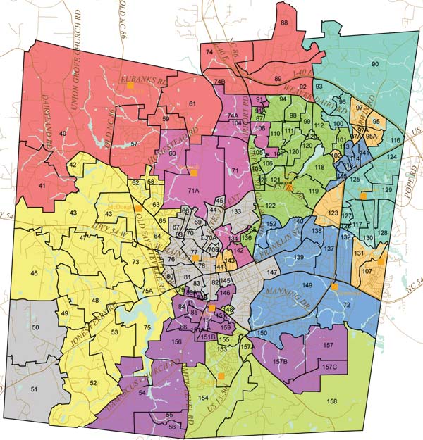
The full map and breakdown of what neighborhoods are going where under the proposal are in this week’s paper.
Here’s the link to the official redistricting site. There’s also a good bit of discussion going on over at Orange Politics.
Also, coverage in the DTH, N&O and Herald-Sun
Here’s the Map and breakdown as it stands now:

Segments moved under 9D include:
- Dairyland Road area, Crescent Ridge, Spring Vista, Union Grove Church Road, the west side of Old N.C. 86, Hickory Forest, Oxbow Crossing, Morris Grove Heights, Old N.C. 86 from Britton Drive to Hickory Forest and Eubanks Road from Rogers Road to Old N.C. 86, from McDougle to the new school;
- Rollingwood subdivision, Crestwood Mobile Home Park, Fairoaks duplexes and the neighborhoods around Bethel Hickory Grove Church Road, from McDougle to the new school;
- Neville Road area, from Frank Porter Graham to McDougle;
- Old Greensboro Highway from Jones Ferry Road to Sesame Road, Sturbridge, Salem Lane, PhilÕs Creek and Johnson’s Mobile Home Park, from Frank Porter Graham to McDougle;
- Sesame Road and Pineview Estates, from Frank Porter Graham to McDougle;
- Bowden Road area, McLennan’s farm, Quailview and Winningham, Frank Porter Graham to Carrboro;
- ones Ferry Road from Damascus Church Road to Bingham Township line, Nine Gates, Mel Oaks and Carolina Forest, from Frank Porter Graham to Carrboro;
- Damascus Church Road from Jones Ferry Road to Meacham Road, Ridgewood, Springhill Forest, Wolf’s Pond and Preston Springs, from Frank Porter Graham to McDougle;
- Jones Ferry Road from Old Fayetteville Road to Old School Road, Moon Ridge and Hairston Road, from Frank Porter Graham to McDougle;
- Hogan Farms, including the east side of Old N.C. 86 from Dairyland Road to Britton Drive, Drew Lane and Homestead Mobile Home Park, from Carrboro to the new school;
- Tally Ho Trail area, from Seawell to the new school;
- Rogers Road area, Meadow Run, Eubanks Road from Rogers Road to the railroad tracks, Homestead Road from Strafford Drive east to railroad tracks, Billabong Lane and Piney Mt. Mobile Home Park, from Seawell to the new school;
- Hilltop Mobile Home Park and N.C. 86 from Eubanks Road north to the school district boundary, from Seawell to the new school;
- Berryhill, Sterlingbrook and Poplar Place Apartments, from Carrboro to McDougle;
- South Greensboro Street from Main Street to Rocky Brook Mobile Home Park, Maple Avenue, Old Pittsboro Road and Roberson Place, from Frank Porter Graham to Carrboro;
- Prince Street/Barnes Street area, from Frank Porter Graham to Carrboro;
- BPW Club Road, The Bluffs, Highland Hills and The Villages Apartments, from Scroggs to Frank Porter Graham;
- Stoneridge and the north side of Whitfield Road from N.C. 86 to Sunrise Road, from Ephesus to the new school;
- Sedgefield and the south side of Whitfield Road, from N.C. 86 to Sunrise Road, North Hills and Creekwood, from Ephesus to the new school;
- North side of Weaver Dairy Road from N.C. 86 to Sunrise Road, including Kensington Trace, Weatherstone, Essex and Lakeview Mobile Home Park, from Ephesus to the new school;
- Chandlers Green, from Rashkis to Ephesus;
- Silver Creek, from Rashkis to Ephesus;
- Chesley Phase I and II, from Rashkis to Ephesus;
- Glen Lennox area, including Glen Lennox Apartments, from Rashkis to Glenwood;
- Colonial Heights, from Seawell to Carrboro;
- Umstead Drive area from Wesley Drive to Estes Drive Extension, Bolinwood Apartments and Village West, from Glenwood to Seawell;
- Church Street area, West Rosemary Street from North Columbia Street to Mitchell Lane, Caldwell Street and McMasters Street, from Glenwood to Seawell;
- Broad Street, Fowler Street, Hill Street, Lloyd Street and Starlite Drive, from Carrboro to Rashkis;
- West Cameron Street area, Westwood, Cameron Glen and McCauley Street, from Glenwood to Carrboro;
- Woodcrest Drive, Ray Road and Smith Level Road from Damascus Church Road to Rock Haven Apartments, from Scroggs to Frank Porter Graham;
- The Reserve, from Scroggs to Frank Porter Graham;
- Beechridge, Bayberry Drive, Arboretum Drive, Poinsett Drive and Grey Bluff, from Scroggs to Frank Porter Graham;
- Hunters’ Ridge and Edgewood Drive area, from Scroggs to Frank Porter Graham;
- the older section of Northwood and Eubanks Road from the UPS facility to N.C. 86, from Seawell to the new school; and
- Old Fayetteville Road, including Autumn Woods Apartments and Ram’s Gate Apartments, from Carrboro to McDougle.