Lighthouses of the United States: Delaware

The United States of America is a federal union of 50 states and a capital district. Delaware is a small state with a coastline about 125 mi (200 km) long. Most of the coast faces east on Delaware Bay and the estuary of the Delaware River leading to the ports of Wilmington, Delaware, and Philadelphia, Pennsylvania. The southernmost part of the state faces east on the Atlantic Ocean.

Delaware has suffered some painful lighthouse losses. The state's oldest lighthouse, at Cape Henlopen, was lost to erosion in 1924. The Bombay Hook Light was demolished in 1974, the New Castle Range Rear Light was destroyed in 1982, the Mahon River Light burned in 1984, just as a preservation group was being formed to save it, and the Mispillion Light burned in 2002 despite the efforts of a preservation group.

Note: the Ship John Shoal and Brandywine Shoal lighthouses in Delaware Bay are actually in New Jersey waters.

Navigational aids in the United States are operated by the U.S. Coast Guard but ownership (and sometimes operation) of historic lighthouses has been transferred to local authorities and preservation organizations in many cases. Delaware lights are the responsibility of the Coast Guard's Sector Delaware Bay with an Aids to Navigation Team at Philadelphia.

ARLHS numbers are from the ARLHS World List of Lights. Admiralty numbers are from volume J of the Admiralty List of Lights & Fog Signals. USCG numbers are from Vol. II of the U.S. Coast Guard Light List.

General Sources
Delaware Bay Lighthouse Keepers and Friends Association
An organization dedicated to saving Delaware Bay lighthouses in both Delaware and New Jersey.
Delaware Bay and River Beacons
Information and historic photos posted by the Lighthouse Keepers and Friends Association.
Delaware Lighthouses
Excellent photos and historical accounts posted by Kraig Anderson.
Online List of Lights - U.S. Atlantic Coast
Photos by various photographers posted by Alexander Trabas. Michael Boucher and Capt. Peter Mosselberger ("Capt. Peter") contributed many of the photos for Delaware.
Lighthouses in Delaware
Photos by various photographers available from Wikimedia.
Leuchttürme USA auf historischen Postkarten
Historic postcard images posted by Klaus Huelse.
U.S. Coast Guard Navigation Center: Light Lists
The USCG Light List can be downloaded in pdf format.
NOAA Nautical Chart Locator
Nautical charts for the coast can be viewed online.
Navionics Charts
Navigation chart for Delaware.


Fenwick Island Light, Fenwick Island, October 2008
Flickr photo copyright 2008 Michael Burton Roark
used by permission

New Castle County (Northern Delaware) Lighthouses

Bellefonte and Edgemoor Lighthouses
* Marcus Hook Range Rear (3)
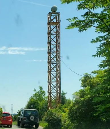
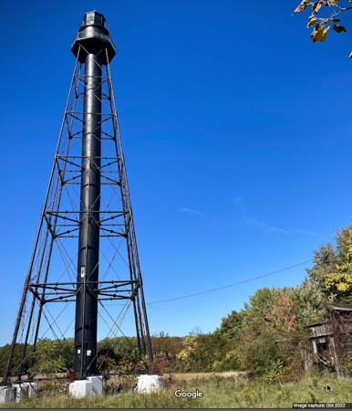
2019 (station established 1915). Active; focal plane 78 ft (24 m); light occulting once every 4 s, red at night and white in the daytime, visible only along the range line. 79 ft (24 m) skeletal tower mounted on a robust pile. Google has a street view and a satellite view of the new light. This range guides vessels downstream. The new rear light stands a few feet southwest of the location of the previous front range light, a 75 ft (23 m) square pyramidal tower with gallery, unpainted. Trabas has Capt. Peter's closeup photo of the old front light and C.W. Bash has a 2008 photo. The front light was moved to a shorter tower upriver with a new light (focal plane 26 ft (8 m); quick-flashing light, red at night and white in the daytime, visible only along the range line). Located in the Delaware River opposite the foot of Hilltop Road in Bellefonte; there's a good view from the north end of nearby Fox Point State Park. Site and tower closed. Owner/site manager: U.S. Coast Guard. ARLHS USA-1416. Admiralty J1314.1; USCG 2-3140.
* Cherry Island Range Rear (2)
About 1970 (station established 1880). Active; focal plane 120 ft (37 m); continuous red light, day and night, visible only along the range line. Approx. 35 ft (11 m) slender square skeletal tower, unpainted. The original brick oil house survives and has been renovated as an equipment room for the modern tower. C.W. Bash has a 2008 photo, Trabas has a photo by Boucher, and Google has a street view and a satellite view. The original lighthouse was demolished around 1970; as seen in a Coast Guard historic photo the light was shown from a square wood tower atop a 2-story wood keeper's house. This range guides vessels northbound toward Philadelphia. Located off Riverside Drive at the north end of River Road Park in Bellefonte. There is a parking area located adjacent to the light tower. Site open, tower closed. ARLHS USA-165; Admiralty J1309.1; USCG 2-2980.
* Marcus Hook Range Rear (2)
1920 (station established 1915). Inactive since 2019. 100 ft (30.5 m) square cylindrical reinforced concrete tower, unpainted; RL-24 aerobeacon. The original 4th order Fresnel range lens is on display at the Independence Seaport Museum in Philadelphia. The original 2-1/2 story brick keeper's house was used as Coast Guard housing until 2004. A 2021 photo is at right, Sreeram Chandrasekaran has a 2023 photo, Trabas has a photo, C.W. Bash has a 2008 photo, Lighthouse Digest has an article on longtime keeper Leslie Millar, and Google has a street view and satellite view. The Coast Guard made minor repairs to the rear range tower in 2000. In March 2005 the lighthouse was offered for transfer under NHLPA, but no preservation groups applied and the lighthouse was withdrawn from the program pending resolution of unspecified "environmental issues." In 2010 the Coast Guard sold the property outside the NHLPA process and it is now a private residence. It's not clear if the sale included the light tower. In June 2019 the Coast Guard deactivated the lighthouse and built new skeletal towers for the front and rear lights. The new rear light (see above) is built in the river near the location of the former front light. Located at 314 Lighthouse Road just south of Lore Avenue in Bellefonte, 1.75 mi (2.8 km) southwest of the front light. Site and tower closed. Owner/site manager: private. . ARLHS USA-474.
Cherry Island Range Front (3)
Date unknown (station established 1880). Active; focal plane 38 ft (12 m); red light, 1 s on, 1 s off. Approx. 33 ft (10 m) square cylindrical skeletal tower with gallery, mounted on a square 1-story equipment room. Tower painted black, equipment room white. Trabas has Capt. Peter's photo and Google has a satellite view. The original 21 ft (6.5 m) lighthouse was part of the Edgemoor Lighthouse Depot, a site now part of a Dupont chemical plant. The National Archives has a photo of the original light and Anderson has a photo of the second light, a pyramidal skeletal tower. Located next to the southern of two piers extending from the Dupont facility. Site and tower closed. Owner: U.S. Coast Guard. Site manager: Dupont Corporation. ARLHS USA-1149; Admiralty J1309; USCG 2-2975.

Marcus Hook Range Rear Light, Bellefonte, July 2021
Google Maps photo by JRACTK

Wilmington and New Castle Lighthouses
Bellevue Range Rear (2)
2000 (station established 1909). Active; focal plane 93 ft (28.5 m); continuous green light. 90 ft (27.5 m) triangular skeletal tower with a small gallery. Trabas has Capt. Peter s photo and Google has a satellite view. This is a range guiding vessels downstream. The front light is on a short skeletal tower. Located about 1 mile (1.6 km) northeast of the historic lighthouse (next entry). Site and tower closed. Owner/site manager: U.S. Coast Guard. Admiralty J1313.1; USCG 2-3085.
* Bellevue Range Rear (1)
1909. Inactive since 2000. 104 ft (32 m) square pyramidal skeletal tower with central cylinder. Entire lighthouse and lantern painted black. The keeper's house (the former Christiana lighthouse) was demolished in 1939. Ben Kranefeld's 2023 photo is at right, Luis Felipe Castro has a good photo, C.W. Bash has a distant 2008 photo, the Coast Guard has a historic photo, Google has a very distant street view from the I-495 expressway, and Google has a satellite view. The lighthouse sits adjacent to the Cherry Island Landfill and growth of the landfill required deactivating the historic light and building a new range tower (previous entry) in 2000. Endangered: in 2007 the lighthouse was listed for transfer under the National Historic Lighthouse Preservation Act (NHLPA), but when no preservation group was interested in applying for it the lighthouse was returned to Coast Guard ownership. It is abandoned and deteriorating; in 2018 it was added to the Lighthouse Digest Doomsday List. Located on the north side of the Christiana River about 600 m (0.4 mi) above the Delaware River in Wilmington; distantly visible downstream from the I-495 bridge over the Christiana River. Site restricted but visitors can obtain permission at the landfill gate to view the lighthouse; tower closed. Owner: U.S. Coast Guard. Site manager: Delaware Solid Waste Authority. ARLHS USA-050.
Deepwater Point Range Rear (2)
Date unknown (station established 1876). Active; focal plane 89 ft (27 m); continuous light, white by day and green by night, visible only on the range line. The tower also carries two passing lights: focal plane 41 ft (12.5 m); white flash every 4 s. 92 ft (28 m) square skeletal tower with gallery, mounted on a square platform supported by a robust pile. Trabas has Capt. Peter's photo, and Google has a good satellite view and a distant street view. This range guides vessels upstream. The original Deepwater range lights were built on the east side of the estuary in New Jersey. They became obsolete when the first Delaware Memorial Bridge was built in 1951. The rear light, a hexagonal skeletal tower essentially identical to the Liston Range Rear Light (see below), was demolished in 1956. The replacement range lights were built in the river, close to the New Jersey shore but in Delaware waters. Located about 600 ft (180 m) off the New Jersey shore and a similar distance south of the original (now the eastbound) span of the Delaware Memorial Bridge (I-295). Accessible only by boat although there must be a good view from the bridge. Site open, tower closed. ARLHS USA-219; Admiralty J1308.1; USCG 2-2910 (range light) and 2-2912 (passing lights).

1909 Bellevue Range Rear Light, Wilmington, May 2023
Google Maps photo by Ben Kranefeld
Deepwater Point Range Front (2)
Date unknown (station established 1876). Active; focal plane 41 ft (12.5 m); white light by day and green by night, with higher intensity on the range line, 1 s on, 1 s off. 33 ft (10 m) square skeletal tower with gallery, mounted on a square platform supported by a robust pile. Trabas has Capt. Peter's closeup photo and Google has a good satellite view. Located 1000 ft (305 m) southwest of the rear light and about 2200 ft (670 m) off the New Jersey shore. Accessible only by boat but there's a good view from the end of Church Landing Road in Pennsville, New Jersey. Site open, tower closed. ARLHS USA-218; Admiralty J1308; USCG 2-2895.
#Bulkhead Bar Range Rear (1)
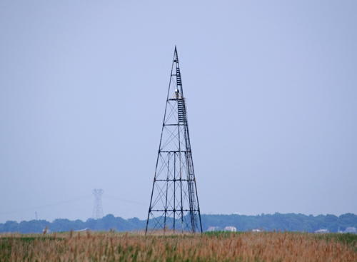
1929. Removed in late 2015 or early 2016. This was an approx. 39 ft (12 m) square pyramidal skeletal tower painted black. Michael Boucher's photo is at right but Google's 2016 street view confirms the removal of the light. Google has a satellite view of the location. This range guided northbound vessels as they turn from the New Castle Range to the Deepwater Point Range. The former front light, on a short skeletal tower at the water's edge, has been repurposed as the rear light of the range, and a new front light was placed in the water. Formerly located at the intersection of 8th Street and Young Street in New Castle. Site open. Current light (ex-Front Light): Admiralty J1306.1; USCG 2-2885.
New Castle Range Rear (2)
1953 (station established 1876). Active; focal plane 110 ft (33.5 m); continuous green light, day and night, visible only along the range line. Approx. 90 ft (27 m) square pyramidal steel tower. Trabas has a view from the estuary, Jesus Martinez has a 2010 photo (misidentified as the front light), and Google has a street view and a satellite view. This range guides vessels upstream. The original lighthouse, a square cylindrical wood tower rising from a front corner of a 2-1/2 story Victorian wood keeper's house, was burned intentionally in 1982 after years of vandalism and neglect. Located just west of DE 9 on Grantham Lane, about 2 mi (3 km) southwest of New Castle. Site and tower closed. Owner/site manager: U.S. Coast Guard. ARLHS USA-547 (original) and 1126 (current); Admiralty J1301.1; USCG 2-2735.
New Castle Range Front (2)
1964 (station established 1876). Active; focal plane 56 ft (17 m); green light, 1 s on, 1 s off, day and night, visible only along the range line. 60 ft (18 m) square cylindrical steel tower. The original keeper's house survives, though altered by modern additions, and the original brick oil house also survives. Trabas has Capt. Peter's photo, a 2021 photo is available, Jesus Martinez has a 2010 photo (misidentified as the rear light), and Google has a satellite view. The original lighthouse, a square cylindrical wood tower, was originally attached to the keeper's house, but in 1886 it was detached and moved about 30 ft (9 m) to adjust the range line. The tower was demolished in 1964. Located on the Delaware River bank at the east end of Grantham Road about 2 mi (3 km) southwest of New Castle and 800 yards (730 m) from the rear range. Site and tower closed. Owner/site manager: U.S. Coast Guard. ARLHS USA-546 (original) and 1125 (current); Admiralty J1301; USCG 2-2730.

Bulkhead Bar Range Rear Light (now lost), New Castle
photo copyright Michael Boucher; used by permission

Delaware City, Port Penn, and Odessa Area Lighthouses
Bulkhead Shoal Channel Range Rear
Date unknown. Active (privately maintained); focal plane 71 ft (22 m); continuous white light. Approx. 69 ft (21 m) square pyramidal skeletal tower. Trabas has a distant view from the estuary and Google has a satellite view. This range guides vessels arriving at the Delaware City Refinery. The front light is on a platform in the river. Located at the water's edge just north of the refinery and about 2 mi (3 km) northwest of Delaware City. Site and tower closed. Owner/site manager: PBF Energy. Admiralty J1304.1; USCG 2-2770.
Baker Range Rear (1)
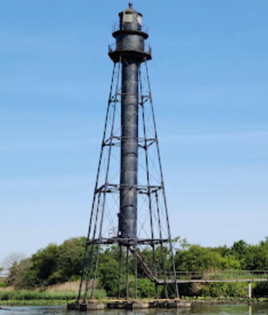
1896 (relocated in 1904). Inactive. 110 ft (33.5 m) triangular pyramidal cast iron skeletal tower, mounted at the end of a short pier projecting into the river. Tower painted black, and the tower also carries a black slatted daymark on its upper portion. James Hatcher's photo is at right, the Coast Guard has a historic photo and Google has a satellite view and a very distant street view from the DE 9 highway. The lighthouse was originally the Old Reedy Island Range Rear Light. This tower was originally equipped with a pulley system that allowed the light apparatus to be lowered into a small lamp house for maintenance. The lamp house and hoisting equipment has been removed. Only a few lights of this design were built and this is the only survivor of the class. Located on the edge of the Delaware River at St. George's Creek, about 1.8 mi (3 km) north of Port Penn. Site and tower closed but the tower can be seen from highway 9. Owner/site manager: U.S. Coast Guard. ARLHS USA-029
Baker Range Rear (2)
Date unknown. Active; focal plane 65 ft (20 m); white light, 3 s on, 3 s off, visible only along the range line. The tower also carries a passing light: focal plane 18 ft (5.5 m); white flash every 4 s. 65 ft (20 m) skeletal tower mounted on a square platform. Trabas has Capt. Peter's photo and Google has a satellite view. Located just offshore about 0.68 mi (1100 m) south of the historic light. Accessible only by boat. Site open, tower closed. Admiralty J1298.1; USCG 2-2510. Passing light: USCG 2-2511.
* [Old Reedy Island Range Rear (1)]
1896. Inactive. The lighthouse was relocated in 1904 as the Baker Range Rear Light (previous entry). The 1-story wood keeper's house and brick oil house survive. Google has a street view and a satellite view. The house remained in service until 1924 as the keeper's house for the Baker Range Lights; thereafter the property was sold as a private residence. Located at 7 South Congress Street in Port Penn. Site open, tower closed. Owner/site manager: private.

1896 Baker Range Rear Light, New Castle, June 2011
Flickr Creative Commons photo by James Hatcher
#Baker Range Front (3)
1924 (station established 1902). Replaced. This was a 36 ft (11 m) square skeletal tower with gallery, mounted on a square platform supported by piles. It has been replaced by a smaller light; Trabas has Capt. Peter's photo and Google has a satellite view. The original lighthouse was 1.3 mi (2 km) north of Port Penn. A temporary post light (1902) was replaced in 1904 by a 2-story wood keeper's house, with the light shone from an upstairs window. Located off the southwestern tip of Reedy Island and 1/2 mi (800 m) east of Port Penn. Accessible only by boat, but there should be a distant view from Port Penn. Site open, tower closed. Owner/site manager: U.S. Coast Guard. ARLHS USA-1146; Admiralty J1298; USCG 2-2505.
* Liston Range Rear
1877 (relocated; was Penn Range Rear Light 1877-1905). Active; focal plane 176 ft (54 m); continuous white light, day and night, visible only on the range line. 120 ft (36.5 m) hexagonal pyramidal cast iron skeletal tower with central cylinder, lantern and gallery; aerobeacon. The original and rare 2nd order Fresnel range lens remains in use. Entire lighthouse and lantern painted black. The 2-story wood keeper's house is a private residence. The original enameled brick oil house also survives. A 2018 photo by Ken Nichols is at right, Luiz Felipe de Castro has a good photo, Trabas has Boucher's photo, Christopher Lucas has a 2009 photo, Lighthouse Digest has Bob Trapani's April 2003 article on the history of the lighthouse, and Google has a street view and a satellite view. This lighthouse is a sibling of the Finns Point and Tinicum Island range lights in New Jersey. The Liston Range extends for 20 miles (32 km), making it the longest navigation range in the U.S. In May 2004 the Delaware River and Bay Lighthouse Foundation signed a 30-year lease of the light tower and oil house from the Coast Guard and in August volunteers began working on the lighthouse. These efforts lagged, however, and in September 2007 the group decided to surrender its lease. In 2012 the lighthouse became available for transfer under NHLPA. When no group qualified to receive it, it was placed on auction in April 2013 and sold for $22,003 to Bill Collins, an Ohio lighthouse fan. Collins later bought the Manistique Breakwater and Skillagalee Lighthouses in Michigan and he has started a preservation organization called Light Keepers Preservation . In 2020 Collins sold the lighthouse to Ken Spicer, the owner of the two keeper's houses. Located on Port Penn Road about 1/2 m (800 m) east of US 13. Site and tower closed. Owner/site manager (tower): private. . ARLHS USA-437; Admiralty J1292.1; USCG 2-2450.

Liston Range Rear Light, Port Penn, JMay 2018
Google Maps photo by Ken Nichols
Liston Range Front (1)
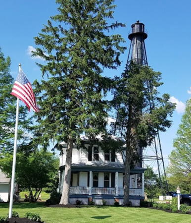
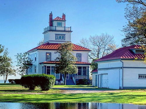
1908. Inactive since 1953. focal plane 45 ft (14 m); white light, 3 s on, 3 s off, day and night, visible only on the range line. 3-story wood keeper's house topped by a square wood cupola. Building painted white with red roofs. The active light (next entry) is on a square pyramidal skeletal tower, painted white, which stands in front of the original lighthouse. A 2020 photo is at right, Luiz Felipe de Castro has a good photo, Stuart McFarlane has a 2021 photo, and Google has a satellite view. The house is a private residence; the owner, for many years, Dr. William Duncan, was a grandson of the station's first keeper. Dr. Duncan maintained the lighthouse in excellent condition and in January 2004 the lighthouse was placed on the National Register of Historic Places. In April 2023 the lighthouse went on sale for $1.2 million and in June 2023 it sold for $950,000. The new owner is not known. Located on the Delaware River off DE 9 near the intersection of Bayview and St. Augustine Roads, about 2.5 mi (4 km) south of Port Penn. Site and tower closed (gated community), although the lighthouse can be seen from route 9. Owner/site manager: private. . ARLHS USA-436.
Liston Range Front (3)
Date unknown (station established 1908). Active; focal plane 45 ft (14 m) (?); white light, 3 s on, 3 s off. 40 ft (12 m) (?) square skeletal tower. Lighthouse painted white. Trabas has a photo. Although the light list data has not changed, it is clear from the photo that the light is now shown on a tower shorter than the previous (1953) tower, a square skeletal tower with an equipment shelter in the base. Located in front of the historic lighthouse. Site and tower closed. Admiralty J1292; USCG 2-2445.
 

Liston Range Front Light, Middletown, November 2020
Instagram photo by kavehko
 
* Reedy Island Range Rear (2)
1910 (station established 1896). Active; focal plane 134 ft (41 m); continuous red light, visible only on the range line. 110 ft (33.5 m) square pyramidal skeletal tower with central cylinder, lantern and gallery; DCB-224 aerobeacon. Entire lighthouse and lantern painted black. Lee Lilly's photo is at right, Trabas has a photo, Craig Siderio has a 2022 photo, another photo is available, and Google has a street view and a satellite view. The original 1-1/2 story wood keeper's house, privately owned for many years, was destroyed by fire on 6 April 2002. , as reported by Lighthouse Digest. This is an outbound (southbound) range; the front light is 2.8 mi (4.5 km) north on a 22 ft (7 m) skeletal tower. The Coast Guard painted the light tower in 2000 and in 2020. After the 2002 fire the property was sold and the new owner has cleared away all of the light station except for the light tower and a wood barn. George Fisher's October 2017 photo showed the barn to be in very poor condition and a few years later it collapsed from the weight of a heavy snowfall. Located at Taylor's Bridge, on DE 9 at the intersection of Taylor's Bridge and Fleming Landing Roads about 8 km (5 mi) southeast of Odessa. Site open (respect private property), tower closed. Owner (tower only): U.S. Coast Guard. Site manager: private. ARLHS USA-692; Admiralty J1299.1; USCG 2-2585.

Kent County (Central Delaware) Lighthouses

#Mahon River (4?)
Date unknown (station established 1831). Removed in 2016. This was a 37 ft (11 m) square skeletal tower mounted on a square platform supported by piles. Trabas has a closeup photo showing an osprey atop the tower and Google has a 2012 street view, but Google's satellite view and 2019 street view confirm the removal of the light. The second (1903) lighthouse, a 2-story wood keeper's house with a lantern centered on the roof, was deactivated in the 1950s and destroyed by fire in 1984. The 1903 lighthouse would be a good candidate for reconstruction. Located just offshore at Port Mahon, south of the mouth of the Mahon River estuary. Site open, tower closed. ARLHS USA-464; ex-Admiralty J1289; ex-USCG 2-2415.
Liston Range Rear Light
Reedy Island Range Rear Light, Odessa, September 2009
Flickr Creative Commons photo by Lee Lilly
* Murderkill River Range Rear
Date unknown (station established 1895). Active; focal plane 65 ft (20 m); continuous green light with higher intensity on the range line. Approx. 59 ft (18 m) square cylindrical skeletal tower. Trabas has a closeup photo and Google has a street view and a good satellite view. The front light is on a wood tripod offshore. The original light was on a wood post; a historic photo is available (the light is mistakenly identified as being in New Jersey). Located beside Bowers Beach Road about 1 mile (1.6 km ) southwest of the waterfront. Site open, tower closed. ARLHS USA-1418; Admiralty J1286.1; USCG 2-2310.
Fourteen Foot Bank
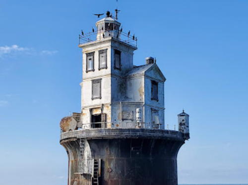
1888. Active; focal plane 59 ft (18 m); white flash every 9 s; red sector covers nearby shoal. 40 ft (12 m) square cylindrical tower with lantern and gallery, attached to a 2-story wood keeper's house, mounted on a round cast iron caisson; solar-powered lens (1997). Fog horn (3 s blast every 30 s). The original 4th order Fresnel lens is on display at the Cannonball House Maritime Museum in Lewes. A photo is at right, Trabas has Capt. Peter's photo, Diane Hamilton has a photo, another good photo is available, and Bing has a satellite view. An attractive and well preserved caisson lighthouse. The lighthouse carries an array of environmental monitoring equipment as part of the University of Delaware's Delaware Bay Observing System. In 2005 the light was offered for transfer under NHLPA. The American Lighthouse Foundation attempted to secure ownership of the lighthouse in partnership with the University but these plans fell through. In 2007 the lighthouse was sold at auction for $200,000 to Michael Gabriel, a Nevada lawyer. Gabriel had plans to renovate the lighthouse and work was to begin in 2009. He planned to use a room in the lighthouse as a brewery, selling the beer produced to help support renovation expenses. Gabriel also continued leasing space on the tower for the University's instrumentation. Located near the center of Delaware Bay, about 10 km (6 mi) east northeast of Big Stone Beach. Site open, tower closed. Owner/site manager: private. . ARLHS USA-305; Admiralty J1266; USCG 2-1575.

Fourteen Foot Bank Light, Delaware Bay, June 2017
Flickr Creative Commons photo by darlingtrk

Sussex County (Southern Delaware) Lighthouses

Mispillion Lighthouses
#Mispillion (2)
1873 (station established 1831). Inactive since 1929. The lighthouse was demolished in June 2002 after a fire on 2 May 2002 left it in ruins; it was a 65 ft (20 m) square cylindrical wood tower rising from one corner of a 2-story gothic style wood keeper's house. The Milford Museum has a historic photo. Formerly used as a restaurant and inn, the light station was listed for sale in 1997 at an asking price of $549,000 (including an adjacent restaurant building and docks). The building was badly deteriorated and critically endangered, with broken windows and visible holes in the roof. In August 2001 the Digest named this the "Most Endangered Lighthouse in the U.S.A." Bob Trapani has contributed some photos taken before and after the fire. A month after the fire the remains of the lighthouse were removed. In 2004 John and Sally Freeman identified themselves as the new owners and announced they were rebuilding the lighthouse as a private residence at Shipcarpenter Square in Lewes; Google has a satellite view and a street view from Burton Avenue. However, the rebuilding used much more new than original material and the house was considerably expanded in size. In February 2022 the lantern of the replica was removed by a crane for repairs and restoration. Meanwhile the state purchased the original site and built the DuPont Nature Center where the lighthouse once stood. Originally located at the mouth of the Mispillion River and the end of Lighthouse Road, off DE 36 about 8 km (5 mi) east of Milford. ARLHS USA-503.
#Mispillion (3)
1924 (relocated from Cape Henlopen in 1929). Inactive since 1984 and removed after 2008. This was a 60 ft (18 m) square pyramidal skeletal tower, painted black.The Coast Guard has a historic photo and Google has a 2008 street view, but Google's satellite view confirms the removal of the tower. Located at the mouth of the Mispillion River and the end of Lighthouse Road, off DE 36 about 8 km (5 mi) east of Milford. Site and tower closed. Owner: Delaware Division of Fish and Wildlife. Site manager: DuPont Nature Center. ARLHS USA-1224.

Lewes Lighthouses
Named for a town in the English county of Sussex, Lewes is pronounced as if it were spelled Lewis. The Delaware town has a permanent population of about 3000.

[Delaware Breakwater Range Rear (Greenhill)]
1881. Inactive since 1918. The tower, a square pyramidal skeletal tower with central cylinder, was relocated to Gasparilla Island in Florida in 1921. The original keeper's house (quite dilapidated) and oil house survive. Trees hide the ruins in Google's satellite view of the area. Huelse has a historic photo of the station. In 2002 the Lewes Greenways and Trails Committee planned to develop a trail to the site and perhaps restore the buildings or reconstuct the lighthouse. In April 2003 the Lewes Greenways and Trails Committee recommended creating a 15-acre park and nature preserve including restoration of the keeper's house and oil house. These plans were never implemented. Located in the Great Marsh at the end of Pilottown Road west of Lewes. Site open. Owner/site manager: City of Lewes. ARLHS USA-1013.
**** Lightship 118 (WLV-539) Overfalls
1938 (Rice Brothers, East Boothbay ME). Decommissioned 1972 (a decorative light is shown from the crow's nest). Single-masted steel lightship, length 116 ft (35.4 m), beam 25 ft (7.6 m). Michael Lore's photo is at right, Anderson has a page for the ship with good photos, Terry Fielden has a 2019 closeup, a good 2014 photo is available, C.W. Bash has an August 2008 photo, and Google has a street view and a satellite view. WLV-539 was the last lightship built in the U.S. Though named now for the former Overfalls Shoal lightship station off Lewes, the ship actually served all of its career off New England, the last ten years of it as the Boston. A local support group, revived in 1999, took ownership of the vessel in December 2001. Engineering studies of the ship in early 2000 revealed it was in bad shape and needed to be moved onshore for preservation. Lighthouse Digest has a November 2003 article on these efforts. In the winter of 2004-05 the ships's electrical system was rebuilt and running lights were installed, as well as the light in the crow's nest. In October 2005 restoration efforts got a big boost from a $275,000 federal grant. In October 2008 the ship was successfully towed 275 mi (440 km) to the Colonna Shipyard in Norfolk, Virginia, for essential repairs. These repairs were complete by March 2009. In March 2009 the Delaware Department of Transportation made $400,000 of federal stimulus funds available for construction of a permanent dock for the ship. Work on that project was underway early in 2010 and the ship was ready to receive visitors by summer. In 2014 the restored pilot house of the former fishing charterboat Stephanie Anne was opened as a museum for the lightship. In November 2017 the ship was towed across Delaware Bay to the Dorchester shipyard for maintenance and repainting of the hull. Located on the Lewes and Rehoboth Canal at the end of Shipcarpenter Street in Lewes. Site open, vessel open for guided tours Thursday through Sunday from Memorial Day weekend (late May) through Labor Day weekend (early September), and Friday through Sunday the rest of September and in early October; group tours can also be arranged out of season. Owner/site manager: Overfalls Maritime Museum Foundation . ARLHS USA-573.
Overfalls Lightship
Overfalls Lightship, Lewes, August 2010
Flickr Creative Commons photo by Michael Lore
[Delaware (Lewes) Breakwater West End (Delaware Breakwater Range Front) (3?)]
Date unknown (station established 1838). Active; focal plane 45 ft (14 m); green flash every 4 s. Approx. 41 ft (12.5 m) square skeletal tower. Trabas has Boucher's photo and Google has a satellite view. Anderson discusses this station on his page for the Delaware Breakwater Light (next entry), and he has a Coast Guard photo of the second (1849) lighthouse. From 1881 to 1903 this was the front light of a range with the Greenhill lighthouse (see above) as the rear light. The historic lighthouse was deactivated in 1903 but it stood until it was demolished sometime in the 1950s. Located at the west end of the detached breakwater sheltering Lewes harbor. Accessible only by boat but there's a good view from the Cape May-Lewes Ferry. Site open, tower closed. Owner/site manager: U.S. Coast Guard. ARLHS USA-1361; Admiralty J1281.2; USCG 2-2030.
** Delaware (Lewes) Breakwater
1885. Inactive since 1996 (a decorative white light is displayed toward the land). 65 ft (20 m) sparkplug style round tower with 3-story round keeper's quarters, lantern and gallery. The original 4th order Fresnel lens is still mounted in the lantern. Dewayne Buress has the 2022 closeup photo seen at right, a 2011 photo is available, Mike Gillispie has a distant street view, and Google has a satellite view. Until 1918 this lighthouse was the front light of a range, the Greenhill lighthouse (see above) being the rear light. The exterior was restored in 1999, when the lighthouse was transferred to the State of Delaware. The tower needed interior restoration. The Delaware River and Bay Authority leased the lighthouse in 2001 with the intention of restoring it and opening it to the public. In 2004 the Authority and the Delaware River and Bay Lighthouse Foundation formed a partnership to carry out these intentions, and the lighthouse was subleased to the Foundation. Volunteers began working to clean up the tower, and public tours began in June 2005. The state repainted the lighthouse in 2020. Located at the east end of a detached breakwater sheltering Lewes harbor. Accessible only by boat but there's a good view from the Cape May-Lewes Ferry. Public tours were suspended for several years due to a lack of state funding, but Cape Water Tours and Taxi now offers tours (reservations recommended) on Wednesday and Saturday June through September. Site open, tower open to guided tours. Owner: State of Delaware. Site manager: Division of Historical and Cultural Affairs. . ARLHS USA-222.


Delaware Breakwater Light, Lewes, June 2022
Google Maps photo by Dewayne Buress

Harbor of Refuge (2)
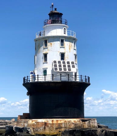
1926 (station established 1902). Active; focal plane 72 ft (22 m); white flash every 5 s; two red sectors cover nearby shoals. 76 ft (23 m) sparkplug style round cast iron lighthouse with 3-story round keeper's quarters, lantern and gallery, mounted on a caisson; solar-powered VRB-25 lens. The DCB-36 aerobeacon used from about 1945 to 1997 has been rebuilt for display on site. Lighthouse painted white, lantern and caisson black. Fog horn (two 2 s blasts every 20 s). A photo is at right, Anderson has an excellent page with good photos, a 2019 closeup photo is available, Bill Britten also has a nice photo, Trabas has Capt. Peter s photo, Marinas.com has aerial photos, and Bing has a satellite view. The present lighthouse replaced a beautiful 3-story octagonal lighthouse built on the same caisson. The exterior of the tower was restored by Coast Guard in 1999. Also in 1999 the Delaware River and Bay Lighthouse Foundation began working for its restoration. In 2001 the Coast Guard repaired the docking platform and ladders to improve safety of access to the building. In April 2002 the Coast Guard granted the Foundation a 20-year lease on the light station and in August the Foundation began preliminary restoration work. The biggest challenge was (and is) maintaining access. The lighthouse faces the open Atlantic and is highly vulnerable to storms; docks at the lighthouse have been destroyed repeatedly by storm waves. The first step was to restore the windows, which had been removed and boarded up by the Coast Guard. The station's dock landing was restored in March 2003 and the first tour was held in June. On September 30, 2004, ownership of the lighthouse was transferred to the Foundation. Damage by Hurricane Isabel in September was quickly repaired but there was concern that the lighthouse was endangered by the poor condition of the Harbor of Refuge Breakwater on which it is built. In late 2007 Congress appropriated $340,000 for repairs to the breakwater. In 2010 winter storms again damaged the station's dock and the lighthouse had to be closed pending repairs. Hurricane Sandy in 2012 caused more damage. Finally, thanks to a $1 million grant, a new dock custom designed to withstand harsh conditions was completed in late fall 2016. Volunteers repainted the tower and restored the interior in 2017 and tours resumed in 2018. In 2022 federal funds were secured to plan repairs to the crumbling breakwater that supports the lighthouse. Located at the end of a long breakwater extending off the tip of Cape Henlopen near Lewes; there's a good view from the Cape May-Lewes Ferry. Accessible only by boat. Site open, tower closed in 2023 pending an Army Corps of Engineers engineering report on the condition of the breakwater. Owner/site manager: Delaware River and Bay Lighthouse Foundation . ARLHS USA-366; Admiralty J1280; USCG 2-1530.

Harbor of Refuge Light, Lewes, July 2011
Flickr Creative Commons photo by kathy1006

Atlantic Coast Lighthouse
*** Fenwick Island
1859. Reactivated (inactive 1978-1982, now privately operated); focal plane 83 ft (25 m); white light, on 7.5 s, off 5.5 s. 84 ft (25.5 m) round brick tower with lantern and gallery. The original 3rd order Fresnel lens remains in use. Lighthouse painted white, lantern black. Original 2-story wood keeper's house and 1881 assistant keeper's house are privately owned. Small museum in lighthouse base. Michael Burton Roark's photo is at the top of this page, Kimi Kover has a 2019 photo, Britten has a good photo of the light station, Trabas has a foggy photo, and Google has a street view and a satellite view. After the Coast Guard deactivated and abandoned the lighthouse in 1978 public protests led the State of Delaware to take ownership in 1981. The resulting restoration in 1981-82 saved and relit the lighthouse and there was another significant renovation in 1997-98. In 2006 the exterior of the lighthouse was repaired and painted; Geoffrey Meyer-van Voorthuijsen has an April photo of the project in progress. In 2017 the state purchased the adjoining keeper's house and announced plans to restore the house and paint the lighthouse. Located on 146th Street at Lighthouse Avenue in Fenwick Island, a few feet from the Delaware-Maryland state line. Site open; keeper's house open Thursday through Monday mornings in July and August and Friday through Sunday in June and September; only the base of the tower is open to visitors. Owner: State of Delaware. Site manager: New Friends of the Fenwick Island Lighthouse. . ARLHS USA-283; Admiralty J1354; USCG 2-0205.

Information available on lost lighthouses:

Notable faux lighthouses:

Adjoining pages: North: Southeastern Pennsylvania | East: New Jersey | South: Virginia | West: Maryland Eastern Shore

Return to the Lighthouse Directory index | Ratings key

Posted 2001. Checked and revised July 4, 2023. Lighthouses: 25. Lightships: 1. Site copyright 2023 Russ Rowlett and the University of North Carolina at Chapel Hill.