Lighthouses of the United States: Florida Keys

The United States of America is a federal union of 50 states and a capital district. Most of the state of Florida occupies a long peninsula separating the Atlantic Ocean from the Gulf of Mexico; the state's western "panhandle" extends westward along the Gulf coast. As a result Florida has by far the longest coastline of any state of the eastern United States. Nearly all of the coast is low and sandy, broken occasionally by narrow inlets leading to shallow lagoons. For visibility at a distance the Florida coast requires tall lighthouses.

The Florida Keys are a chain of some 1700 islands, islets, and sandbars extending in a long arc southwest and south from Miami. Key West, the westernmost inhabited island, is connected to Miami by the 125 miles (200 km) of the Overseas Highway (US 1). Beyond Key West, the last islands in the chain are the uninhabited Dry Tortugas, which are now protected as a national park. Monroe County includes all of the Florida Keys.

Florida has about three dozen traditional lighthouses including several of the country's most famous light towers. The Florida Lighthouse Association (FLA) works for preservation of all the light stations. Nearly all the onshore stations are now supported by local lighthouse societies and FLA helped organize a Reef Lights Association to work for preservation of the offshore lights. Efforts of FLA and local associations have led to restoration projects undertaken or planned at most of the onshore lighthouses. Few states have worked as hard on lighthouse preservation as Florida in recent years.

The word key for an island, used throughout Florida, comes from the Spanish cayo, which in turn was derived from cairi, the word for an island in the language of the indigenous Taíno people, the original inhabitants of Cuba and the Bahamas.

Navigational aids in the United States are operated by the U.S. Coast Guard, but ownership (and sometimes operation) of historic lighthouses has been transferred to local authorities and preservation organizations in many cases. Florida Keys lights are the responsibility of the Coast Guard's Sector Key West.

ARLHS numbers are from the ARLHS World List of Lights. Admiralty numbers are from volume J of the Admiralty List of Lights & Fog Signals. USCG numbers are from Volume III of the U.S. Coast Guard Light List.


Key West Light, Key West, March 2019
Google Maps street view

General Sources
Florida Lighthouse Association
The association works hard for the preservation of lighthouses throughout the state and has encouraged the formation of a number of local preservation societies.
Florida Lighthouses
Excellent photos and visitor accounts for most of the lighthouses, posted by Kraig Anderson.
Lighthouses in Florida
Photos by various photographers available from Wikimedia.
Florida, United States Lighthouses
Aerial photos posted by Marinas.com.
Online List of Lights - U.S. - Atlantic Coast
Photos by various photographers posted by Alexander Trabas.
Lighthouses of Florida
Photos and information from Stephen Wilmoth's "Beach Bum" web site.
Florida Maritime Heritage Trail - Lighthouses
A site posted by the Florida Division of Historical Resources; it has photos and brief accounts for all the lighthouses of the state, with visitor information.
Florida Lighthouses
This site by Bill Britten of the University of Tennesee has some outstanding photos.
Lighthouses of Florida
A site by Bryan Penberthy with photos of many of the lighthouses including some of the offshore lights.
Unmanned Reef Lights of the Florida Keys
A Wikopedia article discusses these poorly known lights.
Leuchttürme USA auf historischen Postkarten
Historic postcard images posted by Klaus Huelse.
U.S. Coast Guard Navigation Center: Light Lists
The USCG Light List can be downloaded in pdf format.
NOAA Nautical Charts
Nautical charts for the coast can be viewed online.
Navionics Charts
Navigation chart for the Keys.
 

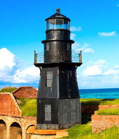
Garden Key Light, Dry Tortugas, November 2012
Wikimedia Creative Commons photo by Acroterion
Key Largo Area Lighthouses
As its name suggests Key Largo is the largest island of the Florida Keys, 33 mi (53 km) long. The permanent population of the island is about 14,000.

Pacific Reef (2)
2000 (station established 1921). Active; focal plane 44 ft (13.5 m); white flash every 4 s. 44 ft (13.5 m) 2-stage square steel skeletal tower with gallery. Anderson has an aerial photo and Google has a satellite view. Wikipedia has the Coast Guard's historic photo of the original light, which was removed in 2000; the lantern room was relocated to Islamorada (see below). Located about 3 miles (5 km) southeast of Elliott Key in Biscayne National Park. Site open; tower closed. Owner/site manager: U.S. Coast Guard. ARLHS USA-576; Admiralty J2968; USCG 3-0935.
Carysfort Reef (2)
2014 (station established 1852). Active; focal plane 40 ft (12 m); three white flashes every 60 s, flashes separated by 10 s. 40 ft (12 m) square skeletal tower mounted on a square platform supported by piles. No photo available but Google has a satellite view. Located about 1500 ft (460 m) north northeast of the historic lighthouse (next entry). Admiralty J2974; USCG 3-0945.1.
Carysfort Reef (1)
1852 (George G. Meade; I.W.P. Lewis, designer). Inactive since 2014. 112 ft (31 m ) octagonal pyramidal wrought iron screwpile tower with an octagonal 2-story keeper's house on a central platform. Lighthouse painted a deep red, except the lantern roof and keeper's house roof are painted white. The original 1st order Fresnel lens is on display at the HistoryMiami museum in Miami. Mario Elaluf's photo is at right, Carol Harrison has a 2008 photo, a third photo is available, Geoffrey Green has a 2023 drone view, and Google has a satellite view. This lighthouse, a historic landmark of civil engineering, is the oldest of the offshore lighthouses of the Florida Keys and the oldest surviving screwpile lighthouse in the nation. Endangered. The Coast Guard refurbished the tower in 1996 but it is currently in poor condition. In 2014 it abandoned the tower, describing it as "unstable and considered unsafe." The active light was moved to a new tower a short distance northeast (previous entry). In 2015 the historic lighthouse was added to the Lighthouse Digest Doomsday List. In 2019 the lighthouse became available for transfer under NHLPA. When no suitable proposals were received the lighthouse was placed on auction sale in February 2022; it sold in May for $415,000. The area is protected as part of the Florida Keys National Marine Sanctuary. Located on the reef in John Pennecamp Coral Reef State Park. Accessible only by boat. Site open, tower closed. Owner/site manager: U.S. Coast Guard. . ARLHS USA-143; ex-Admiralty J2974; ex-USCG 3-0945.

Carysfort Reef Light, June 2022
Google Maps photo by Mario Elaluf
Key Largo [Rebecca Shoal (1) (lantern)]
1886 lantern on 1959 faux lighthouse. Active (privately maintained and unofficial; charted as a landmark). Approx. 33 ft (10 m) square pyramidal tower with lantern and gallery, painted in a red and white checkerboard pattern. The original Rebecca Shoal lighthouse, a 2-1/2 story square wood cottage screwpile, was located 43 miles (69 km) west of Key West (see below). When the lighthouse was demolished in 1953 the lantern was sold for scrap. Saved by a junk dealer in Ocala, it was purchased in 1959 and placed on the faux tower in Key Largo, at the entrance to a short canal. The present owner, David McGraw, renovated the lighthouse for use as private guest house, and it is available for weddings and overnight accommodations. Roberto Matheu has a view from the sea, Lighthouse Digest has an article on the lighthouse and Google has a satellite view. Located on Oleander Circle at the end of Ocean Way in Key Largo. Site and tower closed (private property); the lantern can be seen from the water. Owner/site manager: Key Largo Lighthouse Beach Weddings.
[Harborage Yacht Club]
Date unknown. Active; focal plane about 6 m (20 ft); red flash every 4 s. Approx. 5 m (16 ft) octagonal tower painted with blue and white vertical stripes. Trabas has a photo and Google has a satellite view. Located on a short breakwater at the yacht club entrance. Site open, tower closed. Admiralty J2981; USCG 3-11915.
Mosquito Bank
Date unknown. Active; focal plane 37 ft (11 m); green flash every 4 s. 37 ft (11 m) triangular pyramidal skeletal tower supported by piles. Trabas has a distant view and Google has an indistinct satellite view. Located on the inside (landward side) of an extensive area of coral reefs southeast of Key Largo. Accessible only by boat. Site open, tower closed. Owner/site manager: U.S. Coast Guard. Admiralty J2980; USCG 3-11890.
Molasses Reef
1921. Active; focal plane 45 ft (14 m); red flash every 10 s. 45 ft (14 m) square pyramidal skeletal steel tower on a screwpile foundation, originally with an enclosed lantern. Trabas has a distant view by Klaus Potschien, John Paul Witt has a 2017 photo, and Google has a satellite view. The lantern has been replaced by a daymarker and a small navigation beacon; in addition, the tower now carries an automatic National Weather Service station. Located about 8 miles (13 km) southeast of Key Largo at the southern end of the John Pennecamp Coral Reef State Park. Accessible only by boat (popular scuba diving site). Site open, tower closed. Owner: U.S. Coast Guard. Site manager: NOAA National Data Buoy Center. ARLHS USA-507; Admiralty J2982; USCG 3-0960.

Molasses Reef Light
NOAA National Buoy Data Center photo

Islamorada Area Lighthouses
Islamorada, which calls itself the "Village of Islands," is an incorporated town stretching across five closely-spaced keys: Plantation Key, Windley Key, Upper and Lower Matecumbe Keys, and Tea Table Key. The town has a population approaching 7,000.

* Faro Blanco (2)
2014 (station established in the 1950s). Active (privately maintained and unofficial but charted by Navionics); focal plane about 69 ft (21 m); continuous (?) white light. 65 ft (20 m) octagonal tower with lantern and gallery. First floor of the tower painted red and the rest white with a narrow red band at the top, lantern black. Tom Emmerling has a 2019 photo, Neal Doan has a page with photos, Jeff Wenzlick has a closeup 2017 street view, and Google has a satellite view. Alan Johnson has a 2002 photo of the original lighthouse; it had to be replaced after being heavily damaged by Hurricane Wilma in 2005. Located on the Faro Blanco Pier on the northwest side of Vaca Key. Site open, tower status unknown. Owner/site manager: Faro Blanco Resort .
Hen and Chickens Shoal
Date unknown. Active; focal plane 35 ft (10.5 m); red flash every 2.5 s. 35 ft (10.5 m) triangular pyramidal skeletal steel tower on a screwpile foundation, originally with an enclosed lantern. A closeup photo is available, Anderson has an aerial photo, Trabas has a photo, and Google has a satellite view. The area is protected as part of the Florida Keys National Marine Sanctuary. Located south of Plantation Key. Accessible only by boat. Site open, tower closed. Owner/site manager: U.S. Coast Guard. ARLHS USA-1227; Admiralty J2986; USCG 3-12195.
* Pacific Reef (1) (lantern room)
1921. The lighthouse, a square pyramidal skeletal steel tower on a screwpile foundation, is located about 3 miles (5 km) southeast of Elliott Key (see above). In 2000 the lantern room was relocated to Founders Park in Islamorada, where it is displayed on a square stone pedestal. A closeup photo is available and Google has a satellite view. and a distant street view. Located off US 1 at mile marker 86.5 near the southern end of Plantation Key in Islamorada. Site open (entry fee for non-residents). Owner/site manager: Village of Islamorada (Founders Park).
Alligator Reef (1)
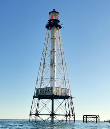
1873. Reactivated (inactive 2013-2023); focal plane 136 ft (41.5 m); white light, pattern unknown. 136 ft (41.5 m) octagonal pyramidal wrought iron screwpile tower with a square 1-story keeper's house on a central platform. Pyramidal tower painted white; lantern, watch room, and pile foundations painted black. The original 1st order Fresnel lens was destroyed by gigantic waves in the Labor Day Hurricane of 1935 (one of the strongest tropical cyclones ever recorded). Gerhard Baumgartner's 2017 closeup photo is at right, a 2023 photo is available, Sean Nash has a 2010 photo, a 2008 photo is available, Lighthouse Digest has an article on life at the station, and Google has a satellite view. Endangered: in 2015 the historic lighthouse was added to the Lighthouse Digest Doomsday List. In 2019 the lighthouse became available for transfer under NHLPA. In 2021 the Friends of the Pool, an Islamorada group that has sponsored swimming races to the lighthouse, was named as its new owner. In 2022 a foundation grant supported an engineeering report; engineers estimated a cost of up to $6 million for a complete restoration and laid out the work in three phases. A solar-powered light was installed in October 2023. Located about 3 miles (5 km) southeast of Lower Matecumbe Key. Accessible only by boat. Site open, tower closed. Visible from ocean beaches in Islamorada. Owner/site manager: Save Alligator Lighthouse ). ARLHS USA-006; ex-USCG 3-0980.
[Alligator Reef (2)]
2015. Active; focal plane 16 ft (5 m); four white flashes every 60 s. 16 ft (5 m) post supporting a small platform. In Anthony Faen's 2018 photo the post light is to the left of the lighthouse. Google has a satellite view. Located a short distance southeast of the historic lighthouse. Site open, tower closed. Owner/site manager: U.S. Coast Guard. Admiralty J2988; USCG 3-0981.

Alligator Reef Light, Islamorada, February 2017
Google Maps photo by Gerhard Baumgartne
Tennessee Reef
1933. Active; focal plane 49 ft (15 m); white flash every 4 s. 50 ft (15 m) hexagonal pyramidal skeletal steel tower with lantern and gallery, mounted on a screwpile foundation. Anderson has a photo, Greg Robinson has a 2022 photo, a 2008 photo (misidentified as Alligator Reef) is available, Wikipedia has the Coast Guard's historic photo, and Google has a satellite view. A popular diving site; mooring buoy available. Located southeast of Long Key. Owner/site manager: U.S. Coast Guard. ARLHS USA-841; Admiralty J2990; USCG 3-0990.

Marathon Area Lighthouses
Marathon is a city occupying most of the Middle Keys, the islands between mileposts 47 and 57 of the Overseas Highway. The city has a population of about 10,000.

East Washerwoman Shoal
Date unknown. Active; focal plane 36 ft (11 m); green flash every 4 s. 36 ft (11 m) triangular pyramidal skeletal tower supported by piles. Trabas has Darlene Chisholm's photo and Google has a satellite view. Located on the inside (landward side) of an extensive area of coral reefs about 1.25 mi (2 km) south of Boot Key in Marathon. Accessible only by boat. Site open, tower closed. Owner/site manager: U.S. Coast Guard. Admiralty J2996; USCG 3-13720.
Sombrero Key (Dry Banks) (1)
1858 (George G. Meade). Inactive since 2015. 160 ft (49 m) octagonal pyramidal wrought iron straightpile tower with a square 1-story keeper's house on a central platform, solar-powered VRB-25 aerobeacon (1997). Lighthouse painted brown. The original 1st order Fresnel lens is on display at the Key West Lighthouse Museum. A 2021 photo is at right, Amber Bost has a 2018 photo, Robert Ryan has a good photo, Luke Sharrett has a 2007 photo, the Coast Guard has a historic photo, and Google has a satellite view. In 2014 the City of Marathon requested that the lens be moved from Key West to Marathon's new city hall; this idea was abandoned when estimates of the cost of a move were much higher than expected. Endangered: in 2015 the lighthouse was added to the Lighthouse Digest Doomsday List. In 2019 the lighthouse became available for transfer under NHLPA. When no suitable proposals were received the lighthouse was placed on auction sale in February 2022; it sold in May for $575,000. Located south of Boot Key on the former Sombrero Key (originally dry land, but the key is now barely awash at low tide). Accessible only by boat. Site open, tower closed. Distantly visible from the Seven Mile Bridge on US 1 and from Sombrero Beach in Marathon. Owner/site manager: U.S. Coast Guard. . ARLHS USA-768; ex-USCG 3-1000.

Sombrero Key Light, Marathon, October 2021
Wikimedia Creative Commons photo by Haligator987
[Sombrero Key (2)]
2015. Active; focal plane 6 m (20 ft); five white flashes every 60 s. 6 m (20 ft) post supporting a small platform. Trabas has Darlene Chisholm's photo, Brandon Deakes has a 2017 photo, and Google has a satellite view. Located about 300 m (0.2 mi) east of the historic lighthouse. Site open, tower closed. Owner/site manager: U.S. Coast Guard. Admiralty J2998; USCG 3-1001.

Key West Area Lighthouses
Key West is a city of about 27,000 residents, the southernmost city of the contiguous United States, and the county seat of Monroe County.
American Shoal
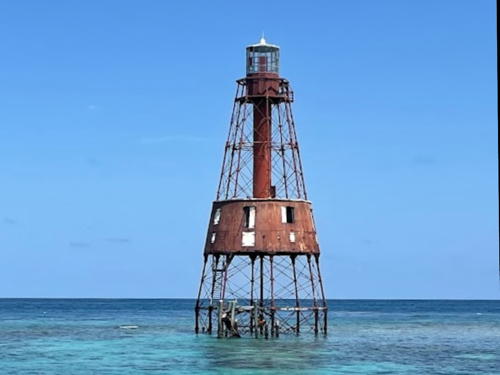
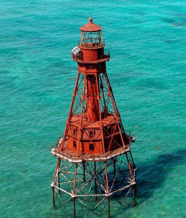
1880. Inactive since 2015. 110 ft (33.5 m) octagonal pyramidal wrought iron straightpile tower with octagonal 2-story keeper's house on central platform, solar-powered VRB-25 aerobeacon. Lighthouse painted red. A photo is at right, Eric Wilsey has a 2018 photo, Lisa Crowther has a 2015 photo, the Coast Guard has a historic photo, Huelse has a historic postcard view, and Google has a satellite view. Sibling of Fowey Rocks. Endangered: the lighthouse was repainted and repaired in 2003, but in 2015 it was added to the Lighthouse Digest Doomsday List. In May 2016 the Coast Guard rescued 20 Cuban migrants clinging to the lighthouse. In 2019 the lighthouse became available for transfer under NHLPA. When no suitable proposals were received the lighthouse was placed on auction sale in February 2022; it sold in May for $860,000. Located southeast of Key West (barely visible from the beach). Accessible only by boat; tower closed. Owner/site manager: U.S. Coast Guard. . ARLHS USA-011; ex-USCG 3-1015.
[American Shoal (2)]
2015. Active; focal plane 6 m (20 ft); four white flashes every 60 s. 6 m (20 ft) post supporting a small platform. Trabas has Darlene Chisholm's photo and Google has a satellite view. Located a short distance east northeast of the historic lighthouse. Site open, tower closed. Owner/site manager: U.S. Coast Guard. Admiralty J3002; USCG 3-1016.
**** Key West (2)
1847 (station established 1825). Inactive since 1969; charted as a landmark. 86 ft (26 m) round old-style brick tower (raised from 66 ft (20 m) in 1894), 175 watt M57 lens. A 3rd order Fresnel lens (1858) is still in the lantern though not in use. The 1825 lighthouse was destroyed by the great hurricane of 1846. The 1-story wood West Indian style keeper's house (1887) is a museum, fully restored with period furnishings. The 1st order Fresnel lens from Sombrero Key Light is on display. Part of Google's 2019 street view is at the top of this page, Patricia Robbins has a 2021 photo, Cindy Lane has a good 2017 photo, Matt Price has a photo, Lighthouse Digest has an August 2006 feature article by Steve Mirsky, Marinas.com has aerial photos, Huelse has a historic postcard view, and Google has a satellite view. The height of the lighthouse was raised 20 ft (6 m) in 1895. The Florida archives has an 1890 photo showing the original appearance of the tower. The Coast Guard has a historic photo taken in 1966. The light station was restored in 1987-90 to its appearance about 1900. In 2015-16 a $665,800 project restored and renovated the lighthouse and keeper's house. Located at Whitehead Street and Truman Avenue in Key West. Site open; tower open daily (admission fee). Owner: Monroe County. Site manager: Key West Art and Historical Society (Lighthouse and Keeper's Quarters) . ARLHS USA-420.

American Shoal Light, Key West
NOAA photo
* Key West Main Channel Range Rear
1969(?). Active; focal plane 75 ft (23 m); green light, 3 s on, 3 s off, visible only on the range line. Approx. 70 ft (21 m) square skeletal tower. The tower carries a rectangular slatted daymark painted red with a white vertical stripe. Trabas has Tom Chisholm's photo and Google has a street view and a good satellite view. Replacing the lighthouse, this range guides vessels approaching Key West from the south. The front light is a 9 m (30 ft) skeletal mast on a platform supported by piles. Located about 1000 ft (300 m) northeast of Fort Zachary Taylor on the Key West waterfront. Site open, tower closed. Admiralty J3014.1; USCG 3-14820.
Key West Cut A Range Rear (2)
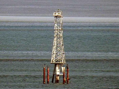
Date unknown. Active; focal plane 70 ft (21 m); white light, 3 s on, 3 s off, visible only on the range line. Approx. 72 ft (22 m) square skeletal tower. Trabas has Michael Boucher's photo (seen at right) and Google's satellite view also shows the foundation pilings of the earlier light. This range guides vessels on a northwest reach following the main channel range. The front light is a 10 m (33 ft) skeletal tower on a platform supported by piles. Located about 1.5 mi (2.5 km) west of the Key West waterfront. Accessible only by boat. Site open, tower closed. Admiralty J3016.1; USCG 3-14850.
[Northwest Passage]
1879. Inactive since 1921; charted as an obstruction. The lighthouse, a 2-story square cottage screwpile, burned in 1971. Foundation pilings remain; the Vintage Key West blog has a page with a photo of the ruins and Google has a satellite view. The legend that author Ernest Hemingway formerly owned the house is certainly incorrect, but he (and many others) may have fished from the platform. There is a painting of Hemingway's boat Pilar at the lighthouse. Located on the south side of the Northwest Channel entrance about 7 miles (11 km) northwest of Key West. Accessible only by boat. Site open. ARLHS USA-557.
Smith Shoal (2)
Date unknown (station established 1933). Active; focal plane 54 ft (16.5 m); white flash every 6 s. 54 ft (16.5 m) triangular skeletal steel tower with a square gallery. The tower carries a NOAA tide gauge. The light is not shown in Google's satellite view. This modern light replaced one of the 1930s skeletal towers; the same thing happened at Pulaski Shoal and Cosgrove Shoal (see below). Located in the Gulf about 5 miles (8 km) north of Northwest Passage Light, that is, about 11 miles (17.5 km) north northwest of Key West. Site manager: U.S. Coast Guard and NOAA National Ocean Service. ARLHS USA-1056; Admiralty J3064; USCG 3-1200.
 

Cut A Range Rear Light, Key West
photo copyright Michael Boucher; used by permission
 
Sand Key (2)
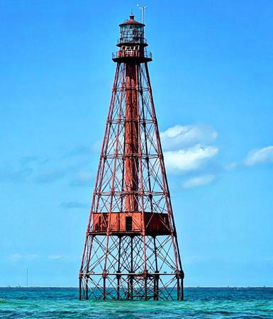
1853 (George G. Meade; I.W.P. Lewis, designer). Station established 1827. Inactive 1989-1998 and since 2014,. 120 ft (36.5 m) square pyramidal wrought iron screwpile tower; solar-powered VRB-25 aerobeacon (1998). Lighthouse painted black; lantern painted white. The original 1st order Fresnel lens is on display at the Coast Guard Academy in Groton, Connecticut. Ali Basye-Featherston's 2022 photo is at right, Tami Harmon has a 2017 photo, Wikimedia has a U.S. Navy 2005 photo by James Brooks, the Coast Guard has a historic photo, Huelse has a historic postcard view, and Google has a satellite view. This lighthouse replaced an old-style brick tower washed away, along with the island on which it stood, by the great hurricane of 1846. The keeper's house and central cylinder, gutted by fire in 1989, were removed in 1996 while the tower was being refurbished. Endangered: needs thorough restoration and repair. In 2014 the Coast Guard abandoned the tower, describing it as "unstable and considered unsafe." The active light was moved to a new tower a short distance north (next entry). In 2015 the historic lighthouse was added to the Lighthouse Digest Doomsday List. In June 2017 the lighthouse became available for transfer under NHLPA. The Reef Lights Foundation applied for ownership but their application was not accepted, and in April 2019 the lighthouse was placed on auction sale. The sale was delayed due to an issue concerning the submerged land under the lighthouse, but it finally ended with a sale for $83,000 in November 2020. Located 7 miles (11 km) southwest of Key West on a small sandbar. Accessible only by boat; tower closed. Owner/site manager: private. . ARLHS USA-724; ex-Admiralty J3006; ex-USCG 3-1055.
Sand Key (3)
2014. Active; focal plane 40 ft (12 m); two white flashes every 15 s. 40 ft (12 m) square skeletal tower mounted on a square platform supported by piles. Trabas has Darlene Chisholm's photo, Brian Guillory has a photo showing both lights, the light is also seen in lowerv right of the photo at right, and Google has a satellite view. Located about 500 ft (150 m) north of the historic lighthouse. Accessible only by boat. Site open, tower closed. Admiralty J3006; USCG 3-1055.1.
Cosgrove Shoal (2)
Date unknown (station established 1935). Active; focal plane 54 ft (16.5 m); white flash every 6 s. 54 ft (16.5 m) triangular skeletal steel tower with a square gallery. Trabas has Darlene Chisholm's distant view and Google has a satellite view. Located south of the Marquesas Keys, about 20 miles (32 km) west southwest of Key West. Site manager: U.S. Coast Guard. ARLHS USA-1055; Admiralty J3052; USCG 3-1070.

Sand Key Light, Key West, May 2022
Google Maps photo by Ali Basye-Featherston

Dry Tortugas Area Lighthouses

The Dry Tortugas are a small group of uninhabited islands and sandbars located far out in the Gulf of Mexico, about 70 miles (113 km) west of Key West. Garden Key, one of the highest islands, is almost completely covered by Fort Jefferson, a mid-19th century fort that also served as a prison. The islands are now included with the surrounding waters in the Dry Tortugas National Park.

#Twenty-eight Foot Shoal
Date uncertain. Demolished. This was a 53 ft (16 m) hexagonal pyramidal skeletal steel tower, probably with enclosed lantern originally. In 2009 the light was replaced by a buoy (USCG 3-1080). Located in the Gulf about 25 mi (40 km) southeast of the Tortugas. Site manager: U.S. Coast Guard. ARLHS USA-1058; ex-Admiralty J3052.5; ex-USCG 3-1080.
#Rebecca Shoal (2)
1985 (station established 1886). Inactive since 2014 and mostly destroyed in 2016. 68 ft (21 m) square pyramidal skeletal tower, mounted on a square platform supported by four straight piles. The Coast Guard has a historic photo of the former lighthouse (1886-1985), a square 1-1/2 story wood keeper's house with a round lantern centered on the roof. The 1886 lantern, rescued from a scrap metal dealer in Ocala, is mounted on a private lighthouse at Key Largo (see above). The Coast Guard abandoned the tower in 2014, describing it as "unstable and considered unsafe." The light was moved to a buoy (USCG 3-1090.1). The tower was largely destroyed by a storm in 2016; only the pile foundation remains. Located on a shoal in the Gulf of Mexico 43 miles (69 km) west of Key West. Accessible only by boat; tower closed. Site manager: U.S. Coast Guard. ARLHS USA-690; ex-Admiralty J3056; ex-USCG 3-1090.
Pulaski Shoal (2)
Date unknown (station established 1933). Active; focal plane 56 ft (17 m); white flash every 6 s. 56 ft (17 m) triangular skeletal steel tower with a square gallery. Google has a satellite view. Wikipedia has the Coast Guard's historic photo of the original light, a hexagonal skeletal tower with lantern and gallery. Located in the Gulf west of Smith Shoal and about 30 miles (50 km) northwest of Key West. Site manager: U.S. Coast Guard. ARLHS USA-676; Admiralty J3058; USCG 3-1185.
Tortugas Harbor (Garden Key, Fort Jefferson) (2)
1876. Inactive since 1921 (a decorative light is displayed and charted). Station established 1826. 82 ft (25 m) hexagonal cast iron tower mounted on the walls of Fort Jefferson, the bastion of the Dry Tortugas. A photo is at the top of this page, Jess Mathis has a 2022 photo, Claudia Dominig has a 2007 closeup photo, Robert Parker wrote a Lighthouse Digest article on the light station, and Google has a street view and a satellite view. The keeper's house (and part of the fort) was destroyed by fire in 1912. This lighthouse replaced an 1825 lighthouse damaged by a hurricane in 1873; the foundation of the older lighthouse survives inside Fort Jefferson. The Coast Guard has a historic photo of the original lighthouse. In September 2017 the Park Service launched a $3 million project to restore the lighthouse. After several years of planning, work by Jablonski Building Conservation began in October 2020; the lighthouse was disassembled and the iron pieces were restored by Robinson Iron in Alexander City, Alabama. The lighthouse was reassemled at its original site by September 2021. Located at the southeastern angle of the hexagonal fort. Accessible by seaplane, passenger ferry or catamaran from Key West. Site open, tower closed. Site manager: Dry Tortugas National Park. . ARLHS USA-316.
Dry Tortugas (Loggerhead Key)
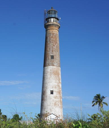
1858 (George G. Meade?). Inactive since 2015. 157 ft (48 m) round early classic brick tower, solar-powered VRB-25 aerobeacon. Lower half of tower painted white, upper half and lantern black. 1-story brick keeper's house (1922), original kitchen, and other outbuildings preserved. The 2nd order bivalve Fresnel lens (1909) is on display at the Coast Guard Training Center in Yorktown, Virginia. The keeper's house is used as housing for park service personnel. Don Sampson's photo is at right, a 2015 photo is available, the Coast Guard has a 2005 photo and an aerial photo taken in 1951, and Google has a street view and a satellite view. Located on Loggerhead Key at the far western end of the Dry Tortugas. Accessible only by boat. Site open, tower closed. Site manager: Dry Tortugas National Park. . ARLHS USA-236; ex-Admiralty J3060; ex-USCG 3-1095.

Dry Tortugas Light, April 2008
Flickr Creative Commons photo by Don Sampson

Information available on lost lighthouses:

Notable faux lighthouses:

Adjoining pages: North: Western Florida | Northeast: Eastern Florida | South: Western Cuba

Return to the Lighthouse Directory index | Ratings key

Posted 2000. Checked and revised August 29, 2023. Lighthouses: 26. Site copyright 2023 Russ Rowlett and the University of North Carolina at Chapel Hill.