Lighthouses of the United States: Missouri

The United States of America is a federal union of 50 states and a capital district. The state of Missouri is in the center of the country on the west bank of the Mississippi River, with Iowa immediately to the north and Arkansas to the south. The state has two important waterways: the Mississippi River flows along its eastern edge, and the Missouri River follows the northwestern border before crossing the state from Kansas City to join the Mississippi at St. Louis. The U.S. Coast Guard Sector Upper Mississippi River, based in St. Louis is responsible for navigation aids on the two rivers but very few of them qualify as lighthouses.

The territory of Missouri was acquired by the U.S. from France in the Louisiana Purchase of 1803. Missouri was admitted to the Union as the 24th state in 1821.

To be listed in the Directory, a lighthouse must actually serve as an aid to navigation. This means it must be located on a navigable lake or river and must be lit as a navigational aid at least during the local boating season.

ARLHS numbers are from the ARLHS World List of Lights. USCG numbers are from volume 5 of the U.S. Coast Guard List of Lights.

General Sources
U.S. Coast Guard Navigation Center: Light Lists
The USCG Light List can be downloaded in pdf format.
GPSNavigationCharts
Navigational chart information for the rivers.
Navionics Charts
Navigation chart for Missouri.

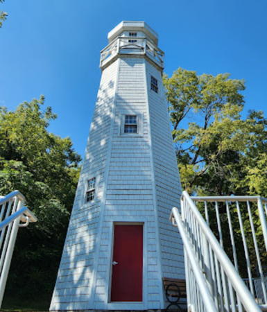
Mark Twain Light, Hannibal, September 2022
Google Maps photo by Michael Hammock

Mississippi River Lighthouses
* [Mark Twain (3)]
2019 (original built in 1935). Active (charted as a landmark by Navionics; a continuous white light is displayed. Approx. 30 ft (9 m) octagonal wood tower with lantern and gallery, painted white. Michael Hammock's 2022 photo is above, Masato Asahara has a 2021 photo, Bryan Hepburn has a photo of the light in action, Jon Loehr has a 2020 street view, and Google has a satellite view. David OBrien has a photo and a more distant view of the 1963 edition of the lighthouse and Warren Dale has a 2017 closeup street view. This is probably the best-known lighthouse of the interior U.S., although it has little if any navigational value. It was built originally to commemorate the 100th anniversary of the birth of the author and humorist Samuel Clemens, better known by his pseudonym Mark Twain. The lighthouse had to be replaced after being heavily damaged by a storm in 1960. The first lighthouse was lit by remote control by President Franklin Roosevelt; the 1963 replacement was lit similarly by President John Kennedy, and when the lighthouse was renovated in 1994 there was another remote relighting by President Bill Clinton. In 2018 the city announced that an engineering study found the tower too deteriorated to be repaired, so it was demolished and built a third time in spring 2019. Located atop Cardiff Hill, a steep bluff above the river in Hannibal, Twain's home town. Site open, tower closed. Owner/site manager: City of Hannibal. . ARLHS USA-915.
* Louisiana
Date unknown. Active; focal plane about 30 ft (9 m); green flash every 4 s. Approx. 30 ft (9 m) rectangular concrete or masonry tower with the light mounted on a front corner of the roof. Google has a street view and a satellite view. The nature of the tower is not known; we need information. Located on the Louisiana Riverfront at the foot of Georgia Street in Louisiana. Site open, tower closed. Site manager: City of Louisiana. USCG 5-15940.
* Duck Club Yacht Club
1991. Active (unofficial but charted by Navionics); focal plane about 40 ft (12 m); continuous white light. 38 ft (11.5 m) round bottle-shaped brick tower with lantern, painted white with red trim. Missouri Life magazine has a photo and a brief history of the lighthouse. Steve Schulte has an excellent photo, a 2012 photo is available (first photo on the page), and Google has a satellite view. The lighthouse marks the entrance to the marina, located on the Mississippi River at the end of Highway V (Blase Station Road) about 13 mi (20 km) north of St. Charles. This location is actually on the southeast side of the river, which twists to the north as it approaches its junction with the Illinois River. Site open, tower closed. Owner/site manager: Duck Club Yacht Club.
St. Louis Water Intake #1
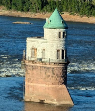
1894. Inactive; not charted by Navionics. Approx. 50 ft (15 mi) stone water intake tower topped by a round tower with a conical roof. The tower is unpainted; the conical roof is green. Erin and Lance Willett's photo is at right, the City of St. Louis has photos of the two towers, Mark Cameron has a street view from the Chain of Rocks Bridge, and Google has a satellite view. This is the older of two historic water intake towers; the younger tower is across the state line in Illinois. The towers are built in the rapids of the Mississippi River, known as the Chain of Rocks. Since 1953 the the rapids have been bypassed by the Chain of Rocks Lock and Canal. However, during the late 1800s and early 1900s the navigation channel passed between the two intake towers, so both were lit; for many years they were also staffed. Located about 1400 ft (425 m) off the west bank of the river and 2500 ft (760 m) south of the I-270 bridge. Accessible only by boat; there is an excellent view from the old Chain of Rocks Bridge (1929), which has been renovated for use by walkers and bicyclists. Site open, tower closed.
* Cape Girardeau Water Intake
Date unknown. Active; focal plane about 45 ft (14 m); green flash every 6 s. Approx. 45 ft (14 m) square cylindrical masonry tower. Upper section of the tower is red; lower portion painted white. Google has a street view and a satellite view. Located on East Cape Rock Road north of Cape Rock Park, on the north side of Cape Girardeau. Site open, tower closed. Owner/site manager: City of Cape Girardeau. USCG 5-17317.

Missouri River Lighthouse
St. Louis County Water Intake (2)
Date unknown (2016?). Active; focal plane about 50 ft (15 m); green flash every 6 s. Light mounted on the west corner of a rectangular white concrete water intake building. Massman Construction, builder of the structure, has a good photo, and Google has a satellite view. Located on the south side of the river off Olive Boulevard in Chesterfield. Site and tower closed. Owner/site manager: Missouri American Water. USCG 5-21285.
St. Louis Water Intake Light
St. Louis Water Intake #1 Light, Chain of Rocks, September 2009
Flickr Creative Commons photo by Erin and Lance Willett

Lake of the Ozarks Lighthouses
* Lake of the Ozarks Lighthouse Pointe (2)
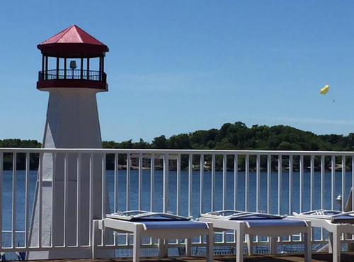
Date unknown. Active (not charted by Navionics); focal plane 40 ft (12 m); flashing white light. 22 ft (7 m) octagonal wood tower, painted white with red trim; lantern painted red. A photo is at right, another photo and a 2017 closeup are available, and Google has a satellite view. Lake of the Ozarks is a large reservoir formed by damming the Osage River in south central Missouri. The lake is surrounded by numerous residential and recreational developments. The first Lighthouse Pointe lighthouse was built as part of a hotel, the Lighthouse Lodge. The lodge has been replaced by Lighthouse Pointe, a large condo development. Located at the end of Lighthouse Road in Lake Ozark. Owner/site manager: Lighthouse Pointe Condominiums. Site open, tower closed.
Mile 38
Date unknown. Active (not charted by Navionics); focal plane about 25 ft (7.5 m); continuous white light. Approx. 20 ft (6 m) round brick tower topped by a small lantern. Google has a satellite view. This lighthouse was built by landowner Dick Morris to warn boaters rounding a 180° bend in the lake. Located on a grassy breakwater at the end of the John Hill Peninsula on the south side of the upper lake. Site and tower closed (private property) but the light is a familiar sight to boaters on the lake. Owner/site manager: private.

Information available on lost lighthouses:

  • Pla-Port (?-?), Lake of the Ozarks. Missouri Life magazine has a historic photo (1/4 the way down the page). This lighthouse was part of a resort active before World War II. It is long gone, but interestingly there is a resort by the same name today at Table Rock Lake.

Lake of the Ozarks Light, Lake Ozark, August 2018
ex-Google Plus photo by Lighthouse Pointe Condominiums

Notable faux lighthouse:

Adjoining pages: North: Iowa | East: Illinois | South: Arkansas | West: Kansas | Northwest: Nebraska

Return to the Lighthouse Directory index | Ratings key

Posted July 15, 2003. Checked and revised October 11, 2023. Lighthouses: 7. Site copyright 2023 Russ Rowlett and the University of North Carolina at Chapel Hill.