Lighthouses of the United States: North Carolina

The United States of America is a federal union of 50 states and a capital district. The state of North Carolina is located on the central east coast of the country. The coast of North Carolina is a chain of sandy barrier islands, called banks, enclosing shallow lagoons called sounds. From Cape Lookout northward the banks are widely separated from the mainland and are called the Outer Banks. The state's three great capes, Cape Hatteras, Cape Lookout, and Cape Fear, extend underwater as dangerous shoals, and the area around these capes earned its name as the Graveyard of the Atlantic. Several of America's tallest and best known lighthouses were built to warn ships away from this dangerous coast.

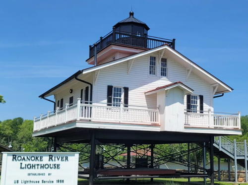
All but one of the cottage screwpile lighthouses of the North Carolina sounds have been lost but two replicas have been built: the town of Plymouth rebuilt the 1866 Roanoke River lighthouse and the town of Manteo rebuilt the 1857 Roanoke Marshes Light. The 1887 Roanoke River lighthouse, the only original screwpile lighthouse surviving, has been saved and restored at Edenton.

Preservation efforts in North Carolina got a huge boost in 1999 through the well-publicized relocation of the Cape Hatteras Light, and the Outer Banks Lighthouse Society has worked hard to raise interest in the work needed at the other lighthouses.

Navigational aids in the United States are operated by the U.S. Coast Guard, and North Carolina aids to navigation are the responsibility of the Coast Guard's Sector North Carolina based at Wilmington with Aids to Navigation Teams at Wanchese for the northern coast, Fort Macon for the central coast and Oak Island for the southern coast. Ownership (and sometimes operation) of historic lighthouses has been transferred to local authorities and preservation organizations in many cases. All the historic Outer Banks lighthouses are now in National Park Service or local ownership.

ARLHS numbers are from the ARLHS World List of Lights, Admiralty numbers are from volume J of the Admiralty List of Lights & Fog Signals, and USCG numbers are from Vol. II of the U.S. Coast Guard Light List.

General Sources
Outer Banks Lighthouse Society
OBLS is an advocate for all of North Carolina's lighthouses.
North Carolina Lighthouses
Great photos and historical accounts by Kraig Anderson.
Online List of Lights - North Carolina
Photos by various photographers posted by Alexander Trabas.
Lighthouses of North Carolina
Photos and accounts by Stephen Wilmoth, the "Beach Bum."
Screwpile Lighthouses of Pamlico Sound
Historical information posted by the Neuse River Sailors Assocation.
Lighthouses in North Carolina
Photos by various photographers available from Wikimedia.
North Carolina, United States Lighthouses
Aerial photos posted by Marinas.com.
Leuchttürme USA auf historischen Postkarten
Historic postcard images posted by Klaus Huelse.
U.S. Coast Guard Navigation Center: Light Lists
The USCG Light List can be downloaded in pdf format.
NOAA Nautical Charts
Nautical charts for the coast can be viewed online.
Navionics Charts
Navigation chart for North Carolina.

Bodie Island Light
Bodie Island Light, Nags Head, May 2012
Wikimedia Creative Commons photo by Ryan Rodgers

Albemarle Sound and Pamlico Sound Lighthouses

Albemarle Sound is the broad estuary of the Chowan and Roanoke Rivers, extending west to east in northeastern North Carolina. It is blocked at its eastern end by the Outer Banks, with its outflow diverted southward to Pamlico Sound and Oregon Inlet. Trapped behind the Outer Banks, Pamlico Sound is the largest lagoon of eastern North America, 80 mi (130 km) long and 15 to 20 miles (24 to 32 km) wide. It is connected to Albemarle Sound by passages around Roanoke Island, Croatan Sound on the west and Roanoke Sound on the east. It is connected to the Atlantic by several narrow passes through the Outer Banks, the largest being Oregon Inlet in the north and Hatteras Inlet in the south. The Tar and Neuse Rivers flow into the western end of Pamlico Sound.

Chowan County Lighthouse
**** Roanoke River (2) (relocated to Edenton)
1887. Inactive since 1941. 35 ft (11 m) square cylindrical wood tower with lantern and gallery, rising from a 2-story wood keeper's house, originally mounted on a screwpile foundation. The original 4th order Fresnel lens was mounted in the tower until recently; it is now in storage for later restoration and display. The lighthouse was built near the western end of Albemarle Sound off the mouth of the Roanoke River, about 6 miles (10 km) northeast of Plymouth. It was relocated in 1955 to downtown Edenton (on the other side of Albemarle Sound) and used first as a rental property and then, from 1960, as the private residence of Emmett Wiggins. After the death of Mr. Wiggins in 1995 the house remained vacant and deteriorating, as seen in the photos on Anderson's page. In May 2005 the Lighthouse Preservation Society of Newburyport, Massachusetts, secured an option to purchase the lighthouse, but nothing came of this effort. Lighthouse Digest placed the lighthouse on the Doomsday List and printed Tim Harrison's September 2006 article on the deteriorated lighthouse. In early 2007 the lighthouse was purchased by the Edenton Historical Commission for $225,000 and in May it was relocated by barge to Colonial Park on the Edenton waterfront. A December 2007 photo by Jean Davis Olecki, an April 2009 photo by Patsy Wooters, and Tom Wicker's January 2010 photo show the lighthouse resting on its moving dolly. In 2009 $1.2 million in federal stimulus money was allocated to permanently site the lighthouse on pilings and restore its exterior. Work began in the spring of 2010 but in June contractors discovered that the soil under the site was contaminated by petroleum. Exterior restoration was completed in October with the building still on its dolly. It was decided to locate the lighthouse on pilings in the harbor and this move took place on 1 May 2012. Hilari Seery's photo at right shows the result of this restoration and relocation. John Martin has a 2022 photo, a 2017 photo is available, J. Dolezal has a street view and Google has a satellite view. Restoration of the interior of the lighthouse began early in 2014 with furnishings loaned by the Edenton Historical Commission, and the building opened in August. Settlers from Virginia founded what is now Edenton in 1658, and it was the residence of the North Carolina governor from 1722 to 1743. Located on the waterfront at the foot of Broad Street in Edenton. Site open, lighthouse open 10 am to 4 pm Tuesday through Saturday. Owner/site manager: N.C. Department of Cultural Resources (Edenton State Historic Site). . ARLHS USA-694M.
Roanoke River Light
1887 Roanoke River Light, Edenton, May 2012
contributed photo copyright Hilari Seery; used by permission

Washington County Lighthouses
*** Roanoke River (1) (replica)
2003 (replica of 1866 lighthouse). Active (unofficial); focal plane about 12 m (39 ft); continuous white light. 1-1/2 story wood keeper's house with lantern centered on the roof, mounted on steel pilings reproducing the original foundation. Lighthouse painted white with black trim; lantern painted black; roof is red. The original, destroyed by ice in 1885, was located near the western end of Albemarle Sound off the mouth of the Roanoke River, about 6 miles (10 km) northeast of Plymouth. Susan Sharpless Smith's photo is at right, Anderson has an excellent page for the lighthouse, Judith Dawson has a 2022 photo, Wilmoth has a good account and photos from a March 2004 visit, Wikimedia has a photo by Julie Kertesz, and Google has a street view and a satellite view. The Washington County Waterways Commission decided to build the replica in 2001 as part of its mission to preserve and interpret the maritime history of the county. Located on the Roanoke River waterfront off US 64 in downtown Plymouth. Parking available. Site open, lighthouse open 11 am through 3 pm Tuesday through Saturday and for group tours by appointment (small admission fee). Owner: Town of Plymouth. Site manager: Roanoke River Lighthouse and Maritime Museum. . ARLHS USA-694H.
Laurel Point (3?)
1880. Active; focal plane 48 ft (15 m); green flash every 4 s. 48 ft (15 m) skeletal tower carrying a square green daymark and mounted on the platform of the original lighthouse. The original hexagonal screwpile lighthouse marked the beginning of the western, narrower section of Albemarle Sound. It was demolished in the 1950s. No photo of the modern light is available but Google has a satellite view. The present light is listed and marked as Light 5AS. Located about 3/4 mi (1.2 km) off Laurel Point in eastern Washington County. Accessible only by boat. Site open, tower closed. ARLHS USA-430; USCG 2-31635.
Roanoke River Light
Roanoke River Light, Plymouth, May 2008
Flickr Creative Commons photo by Susan Sharpless Smith

Hyde County Lighthouses
Gull Shoal (3?)
Date unknown (station established 1891). Active; focal plane 45 ft (13.5 m); white flash every 4 s. 45 ft (13.5 m) square skeletal tower carrying a black daymark and mounted on a square platform supported by piles. No photo of the modern light is available but Google has a satellite view. The original square screwpile cottage lighthouse was demolished in the 1950s. It was replaced by a skeletal tower on the screwpile platform, but that structure has been replaced. Located at the end of a long shoal north of the Pamlico River estuary. Accessible only by boat. Site open, tower closed. ARLHS USA-1029; USCG 2-32145.
Royal Shoal (Light 5RS) (3?)
Date unknown (station established 1867). Active; focal plane 40 ft (12.5 m); quick-flashing green light. 40 ft (12.5 m) square skeletal tower carrying a square green daymark and mounted on a square platform supported by piles. No photo of the modern light is available but Google has a satellite view. The original square screwpile cottage lighthouse has completely disappeared; it may not have been at the exact location of the modern light. Located in the middle of Pamlico Sound marking the northwestern edge of a large shoal area extending from Ocracoke Inlet. Accessible only by boat. Site open, tower closed. ARLHS USA-1161; ex-Admiralty J2425; USCG 2-32375.

Beaufort County Lighthouse
** Washington Docks
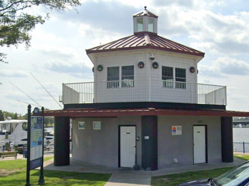
2014. Active (unofficial); focal plane about 35 ft (11 m); white flash every 3 s. 2 story wood building, upper story octagonal, with an octagonal lantern centered on the roof. Upper story and lantern painted white with red roofs. Larry Zicherman's photo is at right, a view from the water is available, Zicherman also has a photo of the lighthouse in action, Peter Wolfgang's photo shows the lighthouse decorated for Christnas 2019, and Google has a street view and a satellite view. Designed to resemble the historic Pamlico Point lighthouse, this building has public restrooms and shower and laundry facilities for boaters on the first floor; the second floor has the city dockmaster's office. Located on Stewart Parkway on the waterfront of Washington, a historic town on the Pamlico River estuary. Site and building open daily. Owner: City of Washington. Site manager: Washington Waterfront Docks.

Pamlico County Lighthouses
[Pamlico Point (2)]
1891 (station established 1828). Demolished in the 1950s; portions of the pilings and supports survive. The wreckage is marked by a warning beacon (white flash every 6 s) on a 15 ft (4.5 m) post. No photo available but Google has a satellite view. This hexagonal cottage screwpile lighthouse replaced an 1828 brick lighthouse that was built on land, although its location is now underwater. Google also has a satellite view of the modern Pamlico Point Light, 0.85 mi (1.4 km) to the east; it is a short skeletal tower on piles (focal plane 25 ft (7.5 m); white flash every 4 s). Located off the point, marking the south side of the entrance to the Pamlico River estuary. Accessible only by boat. Site open. ARLHS USA-579; warning light: USCG 2-32813; modern light: USCG 2-32810.
Washington Dockmaster Office
Washington Docks Light, Washington, July 2014
photo copyright Larry Zicherman; used by permission
Brant Island Shoal (3?)
Date unknown (station established 1864). Active; focal plane 40 ft (12.5 m); white flash every 6 s. 40 ft (12.5 m) square skeletal tower carrying a red daymark and mounted on a square platform supported by piles. No photo of the modern light is available but Google has a satellite view. The original square screwpile cottage lighthouse was demolished and "submerged pilings" are noted on the chart. It was replaced by a skeletal tower on the screwpile platform, but that structure has been replaced. Located in the middle of Pamlico Sound at the end of a long shoal between the mouths of the Pamlico and Neuse River estuaries. Accessible only by boat. Site open, tower closed. ARLHS USA-077; USCG 2-32650.

Outer Banks Lighthouses

The Outer Banks are a string of narrow barrier islands extending about 320 km (200 mi) from the southeastern corner of Virginia to Cape Lookout in North Carolina, interrupted by several passes known in North Carolina as inlets although they function as outlets for runoff from North Carolina's rivers. The northern half of the Banks includes a series of popular seaside resorts extending from Corolla to Nags Head. South of Nags Head most of the islands are included in the Cape Hatteras and Cape Lookout National Seashores. North Carolina Highway 12 traverses the central sections of the Banks from Corolla in the north to Ocracoke in the south, crossing Oregon Inlet by bridge and Hatteras Inlet by ferry. The northern resorts are accessible from the mainland by bridges on US 158 to Kittly Hawk and US 64 to Nags Head; the southern resorts are accessible by Highway 12 and by ferries from Swanquarter and Cedar Island.

Currituck County Lighthouse
**** Currituck Beach (Corolla)
1875 (Dexter Stetson). Active (privately maintained); focal plane 158 ft (48 m); white flash every 20 s. 162 ft (49 m) unpainted round red brick tower with lantern and gallery, attached to a 1-story brick oil house; the original 1st order Fresnel lens is still in use. Sibling of Bodie Island Light (see below). Original 2-1/2 story wood principal keeper's quarters. The visitor center is in the assistant keeper's quarters, a house moved to the light station in 1920 from the former Long Point Light on the west side of Currituck Sound. An original storage building is used for staff offices. A photo is at right, Anderson has a fine page for the lighthouse, Wikipedia's page has a good photo, Wikimedia has additional photos, Trabas has a fine photo by Michael Boucher, Michael Temme-Soifer has a street view, and Google has a satellite view. This was the third great Outer Banks lighthouse built by Dexter Stetson (1815-1899). Like the others it was built on an unusual "floating" foundation, a platform of heavy wood timbers supported by piles. The historic light station was badly deteriorated in 1980 when the Outer Banks Conservationists (OBC) signed a lease to restore the buildings. Four decades of work have restored the station to its original appearance. The lighthouse lantern and gallery were restored in winter 1999-2000. In August 2001 the Coast Guard announced plans to transfer the light station under NHLPA, and a controversy quickly arose when Currituck County sought ownership in opposition to OBC. In early 2003 the National Park Service awarded the lighthouse to OBC and the Secretary of the Interior confirmed the award in July. Despite the fierce opposition of local Congressman Walter Jones, the deed was finally transferred on October 17. This bitter struggle reached ridiculous heights with the County Commission suing OBC for violation of local zoning ordinances. The dispute threatened to upset the entire NHLPA lighthouse transfer process. Finally three of the five commissioners reached an agreement with OBC in April 2006 to accept OBC ownership and cease all litigation. Fortunately the lighthouse is now much better integrated with the community as a unit of the Currituck Heritage Park; the park also includes the Whalehead Club Historic House Museum and the Outer Banks Center for Wildlife Education, both within walking distance of the lighthouse. In March 2020 ICC Commonwealth disassembled and repaired the lantern roof, but with ticket receipts cut off by the Covid-19 pandemic the second phase of the restoration project had to be suspended. Located on the west side of NC 12 in Corolla. Site and tower open daily from one week before Easter through Thanksgiving weekend (site free; there's a fee to climb the tower). Owner/site manager: Outer Banks Conservationists (Currituck Beach Lighthouse) . ARLHS USA-212; Admiralty J2384; USCG 2-0555.
Currituck Beach Light
Currituck Beach Light, Corolla, October 2012
Flickr Creative Commons photo by ctj71081

Dare County Lighthouses
**** Roanoke Marshes (3) (replica)
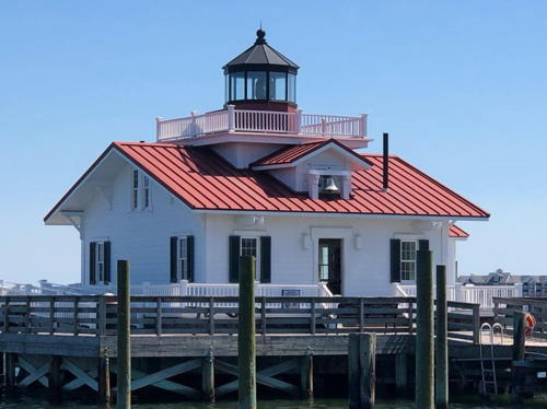
2004 (replica of 1877 lighthouse). Active (unofficial; focal plane about 11 m (36 ft); continuous white light). 1-1/2 story wood keeper's house with lantern and gallery centered on the roof, mounted on a concrete pier. Lighthouse painted white with red trim; lantern painted black. The lantern houses a 4th order Henri LePaute Fresnel lens on loan from the Coast Guard. A 2023 photo is at right, Wikimedia has Morgan Riley's photo (also seen at right), Dani Jace has a photo, Carol Huffman has a photo of the lighthouse in action, Curt Werline has a street view, and Google has a satellite view. This lighthouse is similar to the 1866 Roanoke River Light in Plymouth (see above). The Coast Guard has a photo of the original lighthouse, which was located in Croatan Sound southwest of Roanoke Island. When it was deactivated in 1955 an attempt was made to move the lighthouse on shore, but it collapsed into the sound during the operation. There is a small beacon on the shoal today (ex-Admiralty J2392, USCG 2-31975). In 1995 the town of Manteo decided to build a replica of the lighthouse on an unused concrete pier in Shallowbag Bay just off the town's waterfront. Manteo, the seat of Dare County, is on the east side of Roanoke Island, sheltered by the Outer Banks to the east. The original intention was for the lighthouse to be a centerpiece of the town's centennial celebration in 1999. After long delays to raise funds and obtain necessary permits, construction finally began in 2003 and was completed in September 2004. The building houses a small lighthouse museum. A maritime museum and a fully-restored coastal warning display tower are located onshore near the lighthouse. Located off NC 400, the tourist route winding through historic Manteo. Accessible by walking the short pier. Site open, lighthouse open Monday through Friday (free). Owner: Town of Manteo. Operator/site manager: Roanoke Island Maritime Museum. . ARLHS USA-1032.

Roanoke Marshes Light, Manteo, April 2023
Instagram photo by nccarrieb
**** Bodie Island (3)
1872 (station established 1848) (Dexter Stetson). Active (maintained by the National Park Service); focal plane 156 ft (47.5 m); two white flashes (separated by 2.5 s) every 30 s. 160 ft (49 m) round brick tower with lantern and gallery, attached to a 1-story brick oil house. The original 1st order Fresnel lens is in use. Tower painted with horizontal black and white bands; lantern black. The original 2-story brick duplex keeper's quarters is a ranger office and visitor center with a small museum and gift shop. Two 1-story wood outbuildings are modern additions. Ryan Rodgers's photo appears at the top of this page, Anderson has a great page with wonderful photos, Chris Morris has a 2011 photo, Jim Liestman has a good 2009 photo, Wikimedia has numerous photos, Trabas has Michael Boucher's photo, and Google has a street view and a satellite view. Note: the name of the island and lighthouse is pronounced "Body." This is a classic lighthouse with authentic surroundings little changed in more than a century. It was the second of the three great Outer Banks lighthouse built by Dexter Stetson (1815-1899). There were some repairs to the tower in 1997-98 but extensive renovation was deferred. Ownership of the tower was transferred to the National Park Service in July 2000 and the lighthouse was added to the Lighthouse Digest Doomsday List in September 2000. The Park Service received a $200,000 appropriation for emergency repairs in 2000-01. Matching federal and state grants of $200,000 each in 2001 advanced planning of a full restoration. In spring 2002 work began with removal of lead-based paint from the oil house and tower base. In March 2003 the Coast Guard announced plans to replace the Fresnel lens with a modern plastic lens; preservationists and the park service sharply protested this decision and in the summer of 2004 the Coast Guard agreed to transfer the lens and the responsibility for its restoration and operation to the Park Service. The tower was repainted in April 2004. In August 2004 two large chunks of iron fell from the gallery and a fence was built around the building to protect visitors. Ownership of the 1st order Fresnel lens was transferred to the park service on 25 April 2005. Additional emergency repairs were made in 2007. Plans called for restoration to begin in 2008 but in December 2007 the U.S. Senate dropped the necessary funding from the fiscal 2008 budget. Finally Congress appropriated $3 million for the restoration in March 2009. Work began in September 2009 and continued through March 2011. The lighthouse was restored inside and out; the lens was disassembled, restored, and placed in storage. In January 2011 the Park Service announced that the gallery would need additional work, for which $1.6 million in additional funding was needed, before the tower could be opened for climbing. With the help of North Carolina's two senators the additional funding was secured. Work resumed in March and was completed by spring 2013. The light was reactivated as a private navigational aid on 19 April 2013. Its 150th anniversary was celebrated 1 October 2022. Located on the west side of NC 12 between Nags Head and Oregon Inlet. Site and visitor center open all year (free); tower open for tours Wednesday through Saturday late April through mid October; tower climb tickets must be purchased online in advance. Owner: U.S. National Park Service. Site manager: Cape Hatteras National Seashore (Bodie Island Light Station) . ARLHS USA-067; Admiralty J2386; USCG 2-0590.
* [North River (relocated to Rodanthe)]
1866. Inactive since 1917. Originally this was a rectangular cottage screwpile lighthouse located in the North River (an arm of Albemarle Sound) near Coinjock. On New Year's Eve 1917 shifting ice broke all the legs of of the platform and the lighthouse was abandoned. In 1920 the surviving structure was sold to Dare County. The light tower was removed and the building was moved to Rodanthe on Hatteras Island, where it was used as a school until 1951. The building has since been renovated and reopened as the Rodanthe-Waves-Salvo Community Center. The origin of the building was forgotten until it was rediscovered in 2006 by several citizens researching the history of North River Light at the Outer Banks History Center in Manteo. The building was expanded several times while it served as a school and it no longer resembles the original lighthouse very much. Google has a street view and a satellite view. Located directly across NC 12 from the Chicamacomico Lifesaving Station, a popular tourist destination in Rodanthe. Site open, building open for scheduled activities. Owner/site manager: Dare County. ARLHS USA-1171.
**** Cape Hatteras (2)
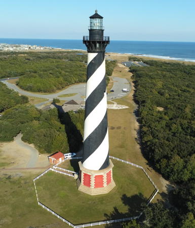
1870 (station established 1803) (Dexter Stetson). Reactivated (inactive 1936-1950) (maintained by the National Park Service); focal plane 192 ft (58.5 m); white flash every 7.5 s. 200 ft (61 m) round brick tower with lantern and gallery, mounted on an octagonal brick base; rotating DCB-224 aerobeacon (1950). The tower is painted with a distinctive black and white spiral pattern; the octagonal base is unpainted red brick; the lantern is painted black. 2-story wood principal keeper's house (1871) and 2-story wood duplex assistant keeper's house (1854). The original 1st order Fresnel lens was mostly dismantled by souvenir hunters while the lighthouse was inactive; most of the remaining portions of the lens are on display at the Graveyard of the Atlantic Museum in Hatteras. In 2006 the original pedestal was removed from the lighthouse and reunited with the lens. For many years there were reports of a Cape Hatteras lens lost during the Civil War but Kevin Duffus has proved that this lens is indeed the one installed in the older tower in 1854. Duffus summarized his research in two Lighthouse Digest articles in October and November 2002. Brick oil house also preserved. Steve Conger's photo is at right, Anderson has a great page for the lighthouse, Wikimedia has many photos, Trabas has a 2012 photo, Marinas.com has aerial photos, Marco Vigogna has a street view, and Google has an excellent satellite view. This lighthouse replaced a 95 ft (29 m) octagonal brick tower, the tallest of the early federal towers, that had been extended to 150 ft (48 m) in 1854. The present tower is the tallest U.S. lighthouse and one of the tallest brick lighthouses in the world. It is one of the most famous of all U.S. lighthouses and it is probably the best-known building in North Carolina. The lighthouse has been recognized as a National Historic Landmark. In 1999 a $12 million relocation and restoration project moved the entire light station 2900 ft (885 m) southwest to escape beach erosion. We have closeup photos of this amazing move. Huelse has a historic postcard view of the lighthouse at its original location, and Wikipedia has an aerial view taken a few months before the move in 1999. In June 2001 a small segment of the spiral stairway fell, causing the park service to close the light tower for repairs. After $545,000 in repairs and renovations the tower reopened on 18 April 2003. In June 2003 a new visitor center opened; this allowed interior restoration of the keeper's houses formerly used for this purpose. A celebration of the 200th anniversary of the light station was held in October 2003, even though Hurricane Isabel had blown out several windows and heavily damaged other areas of Hatteras Island in September. In 2011 Hurricane Irene damaged the roofs of the keepers' houses; the roofs were replaced in March 2012. When the lighthouse was moved, a circle of foundation stones, engraved with the names of keepers, were left at the original location. In 2014, fifteen years after the lighthouse was moved, the sea was threatening this spot and the Park Service moved the stones to the new location outside the visitor center of the station. In 2021 a major repair and restoration project began with preliminary work to remove many layers of paint from the interior of the tower. In 2023 bids were requested for the main part of the project. The Park Service has suggested replacing the modern lens with a replica of the 1st order original. Located south of NC 12 in the village of Buxton. Site open all year, visitor center open daily (free), tower closed during the restoration. Owner: U.S. National Park Service. Site manager: Cape Hatteras National Seashore (Cape Hatteras Light Station). . ARLHS USA-119; Admiralty J2396; USCG 2-0625.
Cape Hatteras Light
Cape Hatteras Light, Buxton, August 2013
Flickr Creative Commons photo by Steve Conger
Diamond Shoals
1967. Inactive since 2001. Texas platform with a square cylindrical light tower, with lantern and gallery, at one corner. A photo is at right, Anderson has a good page for the station, and the Coast Guard has a historic photo, but the tower is not shown in Google's satellite view. The automated light failed in December 2001, and the structure had become too shaky for it to be repaired safely. The Coast Guard replaced the light with a buoy (quick-flashing red light; USCG 2-0640), and NOAA relocated its C-MAN automatic weather station from the platform to a buoy. In October 2012 the abandoned station was sold for $20,000 to Dave Schneider of Richfield, Minnesota. The president of Zap Water Technology, a government supplies and logistics contractor, Schneider has worked to repair the lighthouse and use it as a platform for engineering research. Located 12 miles (19 km) southeast of Cape Hatteras at the end of the infamous Diamond Shoals, a.k.a. the Graveyard of the Atlantic. Accessible only by boat. Owner: Zap Water Technology. Site manager: Diamond Shoals Light Station . ARLHS USA-230; ex-Admiralty J2400; ex-USCG 2-0640.
* Hatteras Inlet
Date unknown. Active; focal plane 48 ft (14.5 m); white light, 3 s on, 3 s off. 45 ft (13.5 m) square skeletal tower built on or over a concrete equipment shelter. Trabas has a photo and Google has a satellite view. Located near the southwest end of Hatteras Island, about 1.1 mi (1.8 km) east of the inlet and 5 km (3 mi) west of Hatteras village. Accessible by an unpaved road (4WD recommended). Site open, tower closed. Site manager: Cape Hatteras National Seashore. Admiralty J2401; USCG 2-0645.

Diamond Shoals Light, June 2012
Wikimedia Creative Commons photo by Qbx101
[Oliver Reef (3) (Hatteras Inlet)]
Date unknown (station established 1874). Active; focal plane 30 ft (9 m); white flash every 6 s. 40 ft (12 m) post, standing next to the pilings of the original lighthouse. No photo available but Google has a satellite view. The original square cottage lighthouse was removed in the 1950s and replaced by a light on the original platform. The platform has now been removed as well, leaving only the pilings. Located in Pamlico Sound about 6 mi (10 km) north of Hatteras Inlet. Accessible only by boat. Site open, tower closed. ARLHS USA-1031; ex-Admiralty J2404; USCG 2-32340.

Hyde County Lighthouse
** Ocracoke
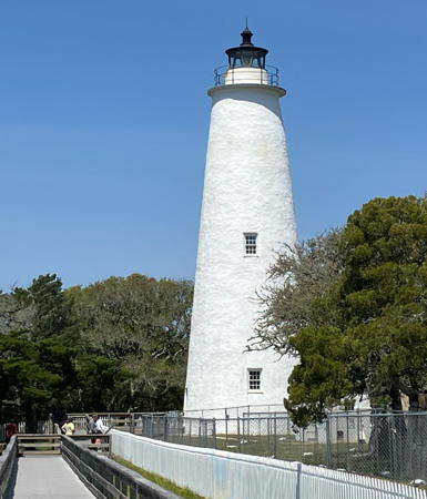
1823 (Noah Porter). Active (maintained by the National Park Service); focal plane 75 ft (23 m); continuous white light. 65 ft (20 m) round tower with lantern and gallery, built of brick with cement veneer; 4th order Fresnel lens (1899). Lighthouse painted white, lantern black. The 2-story brick keeper's house, formerly used a residence for park rangers, is now occupied by volunteer caretakers. This is one of the best built and best preserved examples of an old-style brick lighthouse. The oil house and two storage buildings are also preserved. Shanyne Hiles's photo is at right, Anderson has a fine page with excellent photos, the Town of Ocracoke has a nice page for the lighthouse, Trabas has a good closeup photo, Kevin Adams has a 2021 photo, Marinas.com has aerial photos, Stefen Howard has a street view, and Google has a satellite view. Part of the keeper's house is original, but the building was expanded with a second story in 1897 and a duplex section in 1929. In 2002 the park service moved a fence to provide more parking at the site. In the fall and winter of 2009-10 the lighthouse was closed four months for replacement of the glass in the lantern, repairs to metalwork, and installation of lightning protection. Following several episodes of damage from ocean overwash, the Park Service in 2022 was planning a restoration of the tower; the tower and oil house won't be moved but the keeper's house and othet station buildings will be elevated 2-4 feet. The $3.6 million project began with groundbreaking in December 2023. Located on Lighthouse Road just off NC 12 in the town of Ocracoke. Ocracoke Island is accessible by state ferries from Hatteras (free), Swanquarter (toll), or Cedar Island (toll). Site open (free); limited parking provided; tower closed to climbing but the base is open during the summer season whenever volunteers are available to staff it. Owner: U.S. National Park Service. Site manager: Cape Hatteras National Seashore (Ocracoke Light Station ). ARLHS USA-561; Admiralty J2408; USCG 2-0660.
Ocracoke Light
Ocracoke Light, Ocracoke, September 2008
Flickr Creative Commons photo by Shayne Hiles

Cartaret County Lighthouses
[Harbor Island Bar]
1867. Demolished, probably in the 1950s. The original square platform survives and carries a warning daybeacon. No photo available but Google has a satellite view. Located on King Fish Shoal, the west side of the entrance to Core Sound from Pamlico Sound. This entrance is almost completely shoaled and open only to small craft. Accessible only by boat. Site open, tower closed. ARLHS USA-1160; USCG 2-34320.
* Cape Lookout (2)
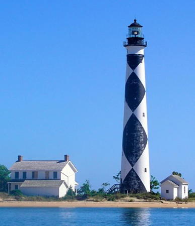
1859 (station established 1812) (W.H.C. Whiting). Active (maintained by the National Park Service); focal plane 150 ft (46 m); white flash every 15 s. 163 ft (49.5 m) round brick tower with lantern and gallery; solar-powered LED lens. The tower is painted in a black-and-white diamond pattern unique in the U.S. The original 1st order Fresnel lens (1856, transferred from the earlier tower) was removed in 1972 and transferred in 1994 to Block Island Southeast Light, Rhode Island. The 2-story brick assistant keeper's house (1873) includes lodging for volunteer caretakers in season; in 2006 the lower story was renovated as a museum. The principal keeper's house (1907) was sold in 1958 and relocated south closer to the point of the Cape. The brick oil house and other buildings are also preserved but in September 2003 Hurricane Isabel swept away the station's coal shed. A photo is at right, Anderson has an excellent page for the lighthouse, Trabas has a postcard photo, Jeff Hrdlicka has a 2018 photo, Marinas.com has aerial photos, Huelse has a historic postcard view, Joella Morris has a street view, and Google has a good satellite view. The lighthouse is somewhat endangered by beach erosion from the west (Barden's Inlet) side of the cape; in the spring of 2006 sand was pumped into the area to protect the keeper's house from the erosion. A Coast Guard project in 1999-2000 provided much-needed interior renovation of the tower. The lighthouse was transferred to the National Park Service in 2003, paving the way to a more complete restoration. Volunteers from the Friends of Cape Lookout helped NPS paint the lighthouse in fall 2004. A new visitor center opened in the spring of 2006. In the fall the DCB-24 aerobeacon (1972) was replaced by a more modern aerobeacon after the rotating mechanism of the older lamps failed. In February 2008 engineers found significant deterioration of the iron stairway and the tower was closed to climbing. Engineering studies were made during the summer of 2008 to plan repairs, and in October 2009 the federal government granted $500,000 to carry them out. The tower reopened in ceremonies on 7 July 2010. In 2017 the aerobeacon was replaced with a solar-powered LED light, reducing the range of the light to 14 mi (22.5 km) from 24 mi (38.6 km). The aerobeacon is to be displayed at the national seashore visitor center. The lighthouse was closed to climbing in 2021 due to concerns about the safety of the stairway. These problems should be resolved during a major restortion getting underway in late 2022, lasting probably several years. In August 2022 the park superintendent said that $8 million was vailable for the restoration, but more will be needed. Meanwhile the Save Cape Lookout Foundation is pushing for beach nourishment along the inlet beside the light station. Located on the South Core Banks, an uninhabited barrier island. The lighthouse is accessible by passenger ferries (toll) from the national seashore's visitor center at Harker's Island year round (limited service December through February) and from a waterfront visitor center in Beaufort, mid April through October. Site open all year, visitor center open daily April through October, tower closed pending restoration of the building. Owner: U.S. National Park Service. Site manager: Cape Lookout National Seashore (Cape Lookout Light Station ). ARLHS USA-126; Admiralty J2430; USCG 2-0670.

Cape Lookout Light, Core Banks, January 2004
Flickr Creative Commons photo by greenkayak73
#Morehead City Channel Range Rear
Date unknown. Removed, probably in 2019. This was a 43 ft (13 m) square cylindrical tower mounted on a square platform supported by piles. Trabas has a photo but in June 2019 this light was missing from its listed location in Google's satellite view. The range has been discontinued. Located at the west end of the Shackleford Banks on the east side of the Inlet. Site open, tower closed. Admiralty J2438.1; ex-USCG 2-29435.
Beaufort Inlet Channel Range Rear
Date unknown. Active; focal plane 57 ft (17.5 m); continuous light, green by night and white by day; also a passing light (white flash every 2.5 s) at a focal plane of 20 ft (6 m). 59 ft (18 m) square cylindrical tower mounted on a square platform supported by piles. Trabas has a photo and Google has a street view and a satellite view. This is the approach range for Beaufort Inlet, which leads to the harbors of Morehead City and Beaufort. The front light is on tripod piles. Located in Taylor Creek (Beaufort harbor) opposite the end of Live Oak Street. Accessible only by boat but easily seen from the Front Street waterfront. Site open, tower closed. Admiralty J2436.1; USCG 2-29379.
Fort Macon Danger B (ex-Range Rear)
Date unknown. Active; focal plane 15 ft (4.5 m); white flash every 4 s. 34 ft (11 m) square cylindrical tower mounted on a square platform supported by piles. Trabas has a photo and Google has a satellite view. The tower formerly carried the rear light of the Fort Macon Reach Range. The range guided arriving vessels as they made the turn into the inlet. The former front light (now Danger Light A) was on a shorter tower. Located in Beaufort Inlet off the east end of the Bogue Banks. Accessible only by boat. Site open, tower closed. Admiralty J2437.1; USCG 2-29402.

Cape Fear Lighthouses

The Cape Fear region occupies the southeastern corner of North Carolina surrounding the city of Wilmington, the state's largest port. Founded in the 1730s and now with a population of about 115,000, Wilmington is located on the east bank of the Cape Fear River about 25 mi (40 km) from the sea. The actual headland of Cape Fear, southernmost of the three North Carolina capes, is the southern tip of Bald Head Island about 3 mi (5 km) southeast of the river's mouth.

Brunswick County Lighthouses
[Cape Fear (Captain Charlie's Station)]
1903. Inactive since 1958, when the light tower, a 150 ft (46 m) pyramidal skeletal lighthouse, was demolished. The concrete foundation pad of the lighthouse remains. Three 1-1/2 story wood keeper's houses have been fully restored and are available for vacation rental. WHQR public radio has a photo of the three houses, Greg Stull has a closeup of one of them, and Google has a satellite view of the station. This former light station is nicknamed for its long-time keeper Charlie Swan. The foundation stones of the lighthouse are located in a roundabout near the headquarters of the Bald Head Island Conservancy (David Jones has a street view), and the light station's brick generator building is the Conservancy's visitor information center. The Old Baldy Foundation is retrieving as much as possible of the original 1st order lens for display at Old Baldy (next entry). Located at the point of Cape Fear on Bald Head Island. The island is accessible by passenger ferry (toll; reservations advised) from Southport. Site open. Owner/site manager: Bald Head Island Conservancy. . ARLHS USA-1028.
** Bald Head Island (Old Baldy) (2)
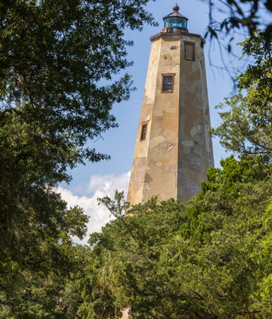
1818 (station established 1794) (Daniel Way). Inactive 1861-1879 and since 1930 (charted as a landmark; a weak decorative light has been displayed since 1988). 100 ft (30.5 m) octagonal round brick tower with mottled stucco veneer, lantern and gallery. The original keeper's houses have been destroyed but a replica of the 1850s principal keeper's house was built in 2000 and serves as a historical museum for the island. Oil house preserved. Tim Engleman's photo is at right, Anderson has a good page for the lighthouse, Jim Dollar has a good photo, J.T. Roberson has a 2022 photo, Marinas.com has aerial photos, Sean Stallings has a street view of the keeper's house museum (rotate the view to see the lighthouse), David Jones has a closeup street view, and Google has a satellite view. This is the oldest brick lighthouse in the U.S. and the last built of the early federal octagonals. It was restored by a local foundation beginning in 1985. Lighthouse Digest has John Hairr's article on the earlier (1794) tower. In 2005 an engineering study by International Chimney Corp. recommended that the mottled and damaged stucco should be removed and replaced with new material, but the actual restoration so far has not followed this advice. About $1 million had to be raised before a full restoration could begin. In the winter of 2016-17 International Chimney carried out necessary repairs, stopping water leaks and replacing corroded iron work and the lantern glass. In 2021 the foundation received a $750,000 grant to carry out a thorough restoration including replacement of the stucco veneer and repairs to the foundation and interior. Located near the ferry landing on Bald Head Island, a private residential development at Cape Fear. Accessible by passenger ferry (toll; reservations advised) from Southport; tours are available that include this site as well as Captain Charlie's Station. Site open (free); museum and tower open daily except Sundays and Mondays March through December. Owner/site manager: Old Baldy Foundation . ARLHS USA-032.
Bald Head Shoal Channel Range Rear/Southport Channel Leading (2)
Date unknown. Active; focal plane 46 ft (14 m); range light: white light, 3 s on, 3 s off, visible only on the range line; passing light: two white flashes every 4 s at a focal plane of 15 ft (5 m). There is also a "precision" leading light displayed on demand: continuous white light on the approach line and red or green light, 1 s on, 1 s off, along the sides of the approach line. 46 ft (14 m) square cylindrical skeletal tower with gallery, mounted on a concrete platform. In 2020 the range light was relocated 2.2 km southwest so it could also carry the leading light for the outbound Southport Range. Google has a satellite view of the new location. Trabas has a photo by Capt. Theo Hinrichs of the light at the old location. The modern range light serves the function for which Old Baldy was built, to guide ships past the Bald Head shoal. The front light is on a short tower 442 yd (400 m) southwest. Located about 3/8 mile (600 m) north of Old Baldy; visible from the lighthouse and (distantly) from the Southport waterfront. Site open, tower closed. Owner/site manager: U.S. Coast Guard. ARLHS USA-1225. Admiralty J2472.1; USCG 2-30335 (standard range light), 30336 (passing light), and 30338 (precision leading light).
Bald Head Island Light
Bald Head Island Light, Bald Head Island, May 2012
Flickr Creative Commons photo by Tim Engleman
Sunny Point Terminal Entrance Range Front
Date unknown. Active; focal plane 90 ft (27.5 m); green flash every 2.5 s, visible only on the range line. Approx. 82 ft (25 m) triangular cylindrical skeletal tower. Trabas has a photo by Capt. Theo Hinrichs and Google has a satellite view. Operated by the U.S. Army, the Sunny Point Terminal is a major port for shipment of supplies (including munitions) to U.S. forces overseas. Located on the waterfront of the terminal, on the Cape Fear River about 8 mi (13 km) north of Southport. Site and tower closed. Owner: U.S. Coast Guard. Site manager: Military Ocean Terminal Sunny Point. Admiralty J2495.17; USCG 2-30562.
Sunny Point Terminal Entrance Range Rear
Date unknown. Active; focal plane 110 ft (33.5 m); green light, 3 s on, 3 s off, visible only on the range line. Approx. 95 ft (29 m) triangular cylindrical skeletal tower. Trabas has a photo by Capt. Theo Hinrichs and Google has a satellite view. Located 417 yd (381 m) north northwest of the front light. Site and tower closed. Owner: U.S. Coast Guard. Site manager: Military Ocean Terminal Sunny Point. Admiralty J2495.171; USCG 2-30563.
Price's Creek Range Front
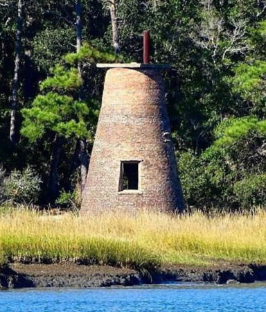
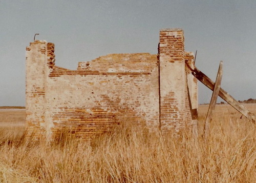
1849. Inactive since 1861. 20 ft (6 m) old-style round brick tower with no lantern. A 2023 photo bySeth Mattern is at right, Heather Knitz has a photo, a June 1996 Lighthouse Digest story profiles the light, Wilmoth has a report with photos from an OBLHS visit in spring 2005, the Southport Times has posted a rare 1939 postcard view, and Google has a satellite view. Long forgotten, this little lighthouse was rediscovered by lighthouse fans during the 1980s. It is on the Lighthouse Digest Doomsday List. The OBLHS visit discovered that the owners, probably concerned about liability issues, have replaced the original stairs in the lighthouse and repaired some of the crumbling brickwork. In April 2001 the Southport Board of Aldermen appointed a committee to consider preservation of the lighthouse and possibly relocating it to Southport, but nothing came of this effort. An August 2016 article confirmed there were no restoration efforts at that time, but in 2023 the owners hired a preservation consultant and reached out to state and area preservation groups, raising hopes that some restoration may be possible. The Southport Times has also acquired a 1908 postcard view of the former rear light, which was mounted on the keeper's house. Located on the west side of the Cape Fear River a short distance north of the Southport-Fort Fisher Ferry terminal. The lighthouse is on private property and is not accessible without special permission. Visible from the Southport-Fort Fisher ferry (toll). Site open, tower closed. Owner/site manager: Archer Daniels Midland, Inc. ARLHS USA-672.
* Cape Fear River Entrance Range Rear
Date unknown. Active; focal plane 101 ft (31 m); white light, 3 s on, 3 s off, visible only on the range line; also a passing light (white flash every 4 s) at a focal plane of 20 ft (6 m). 101 ft (31 m) triangular skeletal tower mounted on a large square platform supported by a robust steel post. Post and platform painted yellow. Michael Miller has a photo, Trabas has a photo by Capt. Theo Hinrichs, and Google has a satellite view. Located just off the beach on the west side of the entrance to the estuary. The adjoining land is the North Carolina Baptist Assembly's Fort Caswell Retreat and Conference Center. Site open to conference center visitors (ask at the gate about access); tower closed. Admiralty J2472.91; USCG 2-30312.

Price's Creek Range Front Light, Southport, July 2023
Google Maps photo by Seth Mattern
** Oak Island
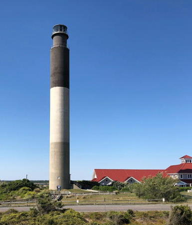
1958. Active (privately maintained); focal plane 169 ft (51.5 m); four quick white flashes every 10 s. 155 ft (47 m) round cylindrical reinforced concrete tower with lantern and gallery; rotating aerobeacon. The upper third of the tower is black, the center third white, and lowest third gray; these colors are in the concrete, not painted. Reynolds Sheldon's photo is at right, Anderson has a good page with photos and historical information, Trabas has a closeup photo by Michael Boucher, Natalie Sharp has a 2022 photo, Marinas.com has aerial photos, and Google has a street view and a satellite view. This is the next-to-last lighthouse built by the Coast Guard and the second tallest concrete light tower in the U.S. Built at an active Coast Guard station, the lighthouse was unharmed when the main station building next door was destroyed by fire in February 2002. In 2003 the Coast Guard announced it would transfer ownership of the lighthouse to the town of Caswell Beach; the transfer ceremony was held on 20 October 2004. The Friends of Oak Island Lighthouse was formed to manage and support the lighthouse. In May 2016 the town loaned the friends group $50,000 to pay half the cost of repairing cracks in the concrete; these repairs were completed by International Chimney Corp. in October 2016. The Coast Guard installed a rotating LED beacon in December 2020. Located on Caswell Beach Road (extension of NC 133), marking the west side of the entrance to the Cape Fear River. Site open, tower open to the second floor level 10 am to 2 pm Wednesdays and Saturdays from Memorial Day (late May) to Labor Day (early September); tours to the top of the tower are available by advance reservation (it's a challenging and vertiginous climb: the tower has ladders, not stairs). Owner/site manager: Town of Caswell Beach. . ARLHS USA-558; Admiralty J2470; USCG 2-0810.
Frying Pan Shoals
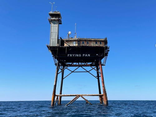
1966. Inactive since 2003. Texas-style platform with a square cylindrical light tower, with lantern and gallery, at one corner. Anderson has a good page for the station and Erin Burge has a 2020 closeup photo, but the platform is not shown in Google's satellite view. The Coast Guard has a historic photo showing the tower on the day of its inauguration, with the departing lightship Frying Pan. (The lightship, WLV-115, is now moored at New York.) The light tower was replaced in November 2003 by a large floating buoy (red flash every 2.5 s) that includes a NOAA C-MAN automatic weather station. In 2009 the structure was offered at auction by the General Services Administration and the high bid of $515,000 was submitted by Shipwrecks, Inc., a South Carolina firm specializing in underwater archaeology. However, the firm failed to carry through to closing. Placed back on the market, the platform was sold for $85,000 to Richard Neal, a real estate developer from Charlotte, North Carolina. Neal restored the structure and opened it for overnight accommodations billed as Eco-Tourism Adventure Weekends. In 2018 Neal announced it was time for a new owner and announced an auction sale of the structure; later he converted the auction to a fractional ownership scheme. Located 32.5 miles (52 km) southeast of Cape Fear at the end of Frying Pan Shoals. Accessible only by boat. Owner/site manager: Frying Pan Tower . ARLHS USA-313; ex-Admiralty J2466; ex-USCG 2-0820. Buoy: USCG 2-0835.

Oak Island Light, Caswell Beach, November 2021
Instagram photo by Reynolds Sheldon

Information available on lost lighthouses:

Notable faux lighthouses:

Adjoining pages: North: Virginia | South: South Carolina

Return to the Lighthouse Directory index | Ratings key

Posted in September 1999, this is the original Lighthouse Directory page. Checked and revised August 1, 2023. Lighthouses: 25. Site copyright 2023 Russ Rowlett and the University of North Carolina at Chapel Hill.